Narrow Results By
- Ernest C. W Lamarque (1879 – 1970, Canadian) 26
- George Weber (1907 – 2002, Canadian) 25
- John Hartman (1950 – , Canadian) 6
- James (Sr.) Simpson (1877 – 1972, Canadian) 3
- Alfred Crocker Leighton, R. C. A. (1901 – 1965, Canadian) 2
- C. Firth 2
- Walter Joseph Phillips, R. C. A. (1884 – 1963, Canadian) 2
- Catherine Perehudoff Fowler (1958 – , Canadian) 1
- Charles Jones Way (1835 – 1919, British) 1
- Dorothy Elsie Knowles Perehudoff (1927 – 2023, Canadian) 1
- MacKay, B.R. 1
- Marmaduke Matthews (1837 – 1913, British) 1
Mather family fonds
https://archives.whyte.org/en/permalink/descriptions269
- Part Of
- Mather family fonds
- Scope & Content
- Fonds consists of three series: I. Mather family; II. Bow River Boat House Ltd.; III. Other material. I. Mather family, 1895-1945, 2.5 cm of textual records, ca.900 photographs (negatives, prints), 3 photograph albums (486 prints), 4 cartographic records. Textual records consist of marriage and b…
- Date Range
- 1895-1953
- Reference Code
- M87 / V397
- Description Level
- 1 / Fonds
- GMD
- Photograph
- Album
- Negative
- Photograph print
- Textual record
- Corporate record
- Map
- Private record
- Published record
- Part Of
- Mather family fonds
- Description Level
- 1 / Fonds
- Fonds Number
- M 87
- V 397
- Sous-Fonds
- M 87
- V 397
- Accession Number
- 309, 594, 1788, 2153, 2788, 3121, 3264
- Reference Code
- M87 / V397
- GMD
- Photograph
- Album
- Negative
- Photograph print
- Textual record
- Corporate record
- Map
- Private record
- Published record
- Date Range
- 1895-1953
- Physical Description
- 13 cm of textual records. -- ca.900 photographs : negatives, prints. -- 3 photograph albums (486 prints)
- History / Biographical
- The Mather family were boat house operators at Banff, Alberta, Canada. William Mather, 1868-1927, emigrated to Ontario from Scotland in 1880 and came west ca.1888 to work for the Eau Claire Lumber Company on the Spray River near Banff. He worked for Raymond M. Rooper's boat house business on the Bow River and, in 1899, purchased the business. The Mather business included steamer tours in the summer and also involved winter sports on the Bow River. William Mather and Margaret McRavey Mather had four children, Jennie, Leslie, Allan and Hazel. With William Mather's death in 1927, the family incorporated its interests as the Bow River Boat House Limited, with Allan Mather as manager. The operation expanded to Lake Minnewanka in 1939. After Allan Mather's death in 1951, the business was sold to Ed Mader
- Scope & Content
- Fonds consists of three series: I. Mather family; II. Bow River Boat House Ltd.; III. Other material.
- I. Mather family, 1895-1945, 2.5 cm of textual records, ca.900 photographs (negatives, prints), 3 photograph albums (486 prints), 4 cartographic records. Textual records consist of marriage and birth certificates, 1896-1900; boathouse and property records, 1895-1917; estate papers, 1928-1943; agreements, 1929, 1931; and, stock certificates, 1929-1945. Photographs consist of: Mather family negatives, [before ca.1945?]; Jennie Mather photographs, [ca.1910-ca.1930]; Leslie Mather photographs, ca.1910-ca.1940; Other photographs, ca.1910-ca.1930. Photographs pertain to Mather family, activities, friends; Mather home and properties; boats and boating on Lake Minnewanka and the Bow River; winter sports, including skating, hockey and skiing; hiking, floods, Banff area mountain views and Rocky Mountain scenic views
- II. Bow River Boat House Ltd., 1929-1951, 7.5 cm of textual records. Series consists of agreements and certificates, 1938-1950; correspondence re Minnewanka bungalow camp, 1941-1942; financial statements, 1937-1951. Maps show locations of Mather and Bow River Boat House Ltd. leaseholds.
- III. Other material, [192-]-1953, 3 cm of textual records.
- Name Access
- Mather, Allan
- Mather, Jennie
- Mather, Leslie
- Mather, William
- Subject Access
- Bow River Boat House
- Family and personal life
- Minnewanka, Lake
- Sports, recreation and leisure
- Access Restrictions
- No restrictions on access
- Photographs are in the public domain (other restrictions may apply)
- Copyright, privacy, commercial use and other restrictions may apply
- Language
- Language is English
- Finding Aid
- Finding aids and reference tools: arrangement outline
- series and file description
- electronic finding aid
- Creator
- Mather, William
- Mather, Allan
- Title Source
- Title based on contents of fonds
- Processing Status
- Processed
This material is presented as originally created; it may contain outdated cultural descriptions and
potentially offensive content.
Read more.
Peace River, Dunvagan, Alberta
https://archives.whyte.org/en/permalink/artifactwbg.04.017
- Date
- 1973
- Medium
- ink on paper
- Catalogue Number
- WbG.04.017
- Description
- A bridge stretches across the Peace River at the centre of the print. The Peace River runs from the centre left side of the print into the distance on the right side of it. From the bottom right corner a road runs into and then is lost on the close side of the river valley. The immediate foregro…
- Title
- Peace River, Dunvagan, Alberta
- Date
- 1973
- Medium
- ink on paper
- Description
- A bridge stretches across the Peace River at the centre of the print. The Peace River runs from the centre left side of the print into the distance on the right side of it. From the bottom right corner a road runs into and then is lost on the close side of the river valley. The immediate foreground is a brown, grassy, shrubby area which gradually turns to green as it crosses the road and descends into the river valley. The opposite side of the river valley is mainly grey. The sky is a heather pink colour with a few tan coloured clouds in it.
- Credit
- Gift of George Weber, 1973
- Catalogue Number
- WbG.04.017
This material is presented as originally created; it may contain outdated cultural descriptions and
potentially offensive content.
Read more.
Geology and structure cross section: Fording River, British Columbia
https://archives.whyte.org/en/permalink/catalogue24712
- Medium
- Library - Book (including soft-cover and pamphlets)
- Map
- Published Date
- 1992
- Author
- Price, R.A.
- Publisher
- Ottawa : Calgary : Geological Survey of Canada
- Call Number
- C7-1.24
- Author
- Price, R.A.
- Responsibility
- R.A. Price [et al.]
- Publisher
- Ottawa : Calgary : Geological Survey of Canada
- Published Date
- 1992
- Physical Description
- 1 map : col
- Scale
- 1:50,000
- Notes
- (Map 1824A)
- Accession Number
- 26,000
- Call Number
- C7-1.24
- Collection
- Archives Library
This material is presented as originally created; it may contain outdated cultural descriptions and
potentially offensive content.
Read more.
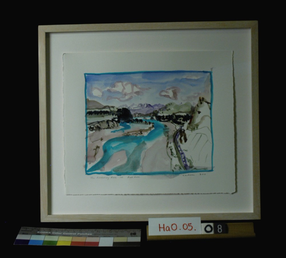
The Kootenay River at the Bull River
https://archives.whyte.org/en/permalink/artifacthao.05.08
- Date
- 2010
- Medium
- watercolour on paper
- Catalogue Number
- HaO.05.08
- Description
- Watercolour of Kootenay and Bull Rivers, small mountains in background, trees on either side of river.
1 image
- Title
- The Kootenay River at the Bull River
- Date
- 2010
- Medium
- watercolour on paper
- Dimensions
- 24.5 x 29 cm
- Description
- Watercolour of Kootenay and Bull Rivers, small mountains in background, trees on either side of river.
- Credit
- Gift of John Hartman, Tiny, 2014
- Catalogue Number
- HaO.05.08
Images
This material is presented as originally created; it may contain outdated cultural descriptions and
potentially offensive content.
Read more.
Preliminary map : Bighorn River, Alberta
https://archives.whyte.org/en/permalink/catalogue24728
- Medium
- Library - Book (including soft-cover and pamphlets)
- Map
- Published Date
- 1941
- Author
- MacKay, B.R.
- Publisher
- Ottawa: Geological Survey of Canada
- Call Number
- C7-2.12, C7-2.12a
- Author
- MacKay, B.R.
- Publisher
- Ottawa: Geological Survey of Canada
- Published Date
- 1941
- Physical Description
- 2 maps
- Scale
- Sccale: 2 inches = 1 mile
- Notes
- Map 41-9
- Accession Number
- 5000
- Call Number
- C7-2.12, C7-2.12a
- Collection
- Archives Library
This material is presented as originally created; it may contain outdated cultural descriptions and
potentially offensive content.
Read more.
The Three Sisters, Canmore, Alberta
https://archives.whyte.org/en/permalink/artifactwbg.04.007
- Date
- 1971
- Medium
- ink on paper
- Catalogue Number
- WbG.04.007
- Description
- In the lower foreground of the print, the Bow River is visible and meanders away into the distance. Dark trees are visible on either side of the print and are reflected in the river. In the distance and in the centre of the print are the Three Sisters, covered in snow. Green hills lead up to the…
- Title
- The Three Sisters, Canmore, Alberta
- Date
- 1971
- Medium
- ink on paper
- Description
- In the lower foreground of the print, the Bow River is visible and meanders away into the distance. Dark trees are visible on either side of the print and are reflected in the river. In the distance and in the centre of the print are the Three Sisters, covered in snow. Green hills lead up to the peaks.
- Credit
- Gift of George Weber, 1973
- Catalogue Number
- WbG.04.007
This material is presented as originally created; it may contain outdated cultural descriptions and
potentially offensive content.
Read more.
AAF aeronautical chart : North Saskatchewan River / compiled for the U.S. Army Air Forces by the U.S. Coast and Geodetic Survey
https://archives.whyte.org/en/permalink/catalogue24364
- Medium
- Library - Maps and blueprints (unannotated; published)
- Map
- Published Date
- 1943
- Publisher
- Washington, D.C.
- Call Number
- C6-12.1
- Publisher
- Washington, D.C.
- Published Date
- 1943
- Physical Description
- 1 map : col
- Scale
- 1 : 1,000,000
- Subjects
- Saskatchewan River, North
- Aviation
- Accession Number
- 4008
- Call Number
- C6-12.1
- Collection
- Archives Library
This material is presented as originally created; it may contain outdated cultural descriptions and
potentially offensive content.
Read more.
[Adams River 82M/11 East, B.C.]
https://archives.whyte.org/en/permalink/catalogue23443
- Medium
- Library - Maps and blueprints (unannotated; published)
- Map
- Published Date
- 1961
- Publisher
- Dept. of Mines and Technical Surveys
- Call Number
- NTS
- 82M/11E
- Publisher
- Dept. of Mines and Technical Surveys
- Published Date
- 1961
- Physical Description
- 1 map : col
- Scale
- Scale: 1:50,000
- Relief: Contour interval 100 ft.
- Subjects
- Adams River
- British Columbia
- Notes
- National Topographic System
- Accession Number
- 3000
- Call Number
- NTS
- 82M/11E
- Collection
- Archives Library
This material is presented as originally created; it may contain outdated cultural descriptions and
potentially offensive content.
Read more.
[Adams River 82M/11 West, B.C.]
https://archives.whyte.org/en/permalink/catalogue23444
- Medium
- Library - Maps and blueprints (unannotated; published)
- Map
- Published Date
- 1961
- Publisher
- Dept. of Mines and Technical Surveys
- Call Number
- NTS
- 82M/11W
- Publisher
- Dept. of Mines and Technical Surveys
- Published Date
- 1961
- Physical Description
- 1 map : col
- Scale
- Scale: 1:50,000
- Relief: Contour interval 100 ft.
- Subjects
- Adams River
- British Columbia
- Notes
- National Topographic System
- Accession Number
- 3000
- Call Number
- NTS
- 82M/11W
- Collection
- Archives Library
This material is presented as originally created; it may contain outdated cultural descriptions and
potentially offensive content.
Read more.
Alberta : Athabaska sheet
https://archives.whyte.org/en/permalink/catalogue24415
- Medium
- Library - Maps and blueprints (unannotated; published)
- Map
- Published Date
- 1914
- Publisher
- Ottawa: Office of the Surveyor General
- Edition
- 2d ed.
- Call Number
- C9-2.4
- Edition
- 2d ed.
- Publisher
- Ottawa: Office of the Surveyor General
- Published Date
- 1914
- Physical Description
- 1 map
- Scale
- Scale: 1:190,080
- Subjects
- Athabaska River
- Notes
- Sectional map
- Accession Number
- 5576
- 4008
- Call Number
- C9-2.4
- Collection
- Archives Library
This material is presented as originally created; it may contain outdated cultural descriptions and
potentially offensive content.
Read more.