Narrow Results By
Margaret Oliver fonds
https://archives.whyte.org/en/permalink/descriptions55186
- Part Of
- Margaret Oliver fonds
- Scope & Content
- Fonds consists of transparency slides, maps, handwritten notes and club records, song books, and scrapbooks pertaining to Margaret Ruth Oliver and the Tuesday Hikers club.
- Date Range
- 1971-2010
- Reference Code
- M569 / V793
- Description Level
- 1 / Fonds
- GMD
- Textual record
- Photograph
- Transparency
- Published record
- Private record
- Scrapbook
- Map
- Organization record
- Part Of
- Margaret Oliver fonds
- Description Level
- 1 / Fonds
- Fonds Number
- M569 / V793
- Sous-Fonds
- M569
- V793
- Accession Number
- 2017.8656
- Reference Code
- M569 / V793
- GMD
- Textual record
- Photograph
- Transparency
- Published record
- Private record
- Scrapbook
- Map
- Organization record
- Date Range
- 1971-2010
- Physical Description
- 28 photographs : col. slides -- 1.5 m of textual records (3 binders -- 1 record book -- 10 song books -- maps, annotated -- 11 scrapbooks)
- History / Biographical
- Margaret Ruth Oliver was born on December 19, 1927 to parents Edgar and Gladys (Brazier) Hammett in Winnipeg, Manitoba. Margaret's siblings include Dorothy (1922), Muriel "Miv" (1923), John (1929), and Jean (1933). Margaret graduated from United College (Winnipeg) in 1949 with a B.Sc. degree, and worked as an Assistant Librarian at the University of Manitoba afterwards. Margaret later enrolled in a Laboratory Technician program at the University of Manitoba Medical College. Margaret married Thomas Albert Oliver, a fellow University of Manitoba alumnus, on September 25, 1954. The couple moved to Calgary for work (Thomas taught at the University of Calgary, and Margaret worked for a geophysical company). Margaret travelled extensively following the death of her husband in 1997, visiting places such as Nepal, Cambodia, Russia, Egypt and Greenland. In 1971, Margaret formed a hiking group within the University Faculty Women's Club (F.W.C.) through the University of Calgary. In 1976, this group became a private club called the Tuesday Hikers, which no longer held any affiliation to the F.W.C. Trips included weekly hikes and/or ski trips, as well as longer backpacking excursions.The club is still active as of 2022.
- Scope & Content
- Fonds consists of transparency slides, maps, handwritten notes and club records, song books, and scrapbooks pertaining to Margaret Ruth Oliver and the Tuesday Hikers club.
- Notes
- Materials are unprocessed and stored in three boxes: Box 1: 1 envelope "T. Hikers' Slides" - 28 film transparencies and printed notes; various maps with handwritten notes Box 2: 1 record book "T.H. Record Book" - handwritten lists and statistics of trips, attendance, miles; 2 binders with handwritten notes, titled "National Parks - Banff and Assiniboine" and "Nat'l Parks - Glacier + Jasper" Box 3: 1 binder titled "Tues. Hikers- Past Members and Guests"; 10 song books; trail, park and road maps; 11 scrapbooks, 1971-2010
- Name Access
- Oliver, Margaret
- Subject Access
- Hiking
- Travel
- Recreation
- Club
- Map
- Trails
- Music
- Entertainment
- Geography
- Geographic Access
- Canada
- Alberta
- Banff National Park
- Jasper National Park
- Assiniboine
- British Columbia
- Glacier National Park
- Language
- English
- Biographical Source Notes
- https://biblio.uottawa.ca/en/node/16056
- Title Source
- Title based on content in fonds
- Processing Status
- Unprocessed
This material is presented as originally created; it may contain outdated cultural descriptions and
potentially offensive content.
Read more.
Auyuittuq National Park
https://archives.whyte.org/en/permalink/descriptions54979
- Part Of
- Murray Hay fonds
- Scope & Content
- File consists of 1 painting : landscape ; 50.5 x 39.5 cm. File pertains to a map Murray Hay created of Auyuittuq National Park in Nunavut, Canada. File includes 1 colour painting of the park and surrounding area (Nunavut, Baffin Island) and one sheet of tracing paper that is annotated and taped wit…
- Date Range
- ca.1980-ca.1989
- Reference Code
- V795 / II / C / vi / 1
- Description Level
- 5 / File
- GMD
- Map
- Painting
- Private record
- Part Of
- Murray Hay fonds
- Description Level
- 5 / File
- Fonds Number
- M570 / V795
- Series
- V795 / II : Unpublished Material
- Sous-Fonds
- V795
- Sub-Series
- V795 / II / C : Canada [general] / vi : Auyuittuq National Park
- Accession Number
- 2020.03
- Reference Code
- V795 / II / C / vi / 1
- Date Range
- ca.1980-ca.1989
- Physical Description
- 1 painting : landscape ; 50.5 x 39.5 cm
- Scope & Content
- File consists of 1 painting : landscape ; 50.5 x 39.5 cm. File pertains to a map Murray Hay created of Auyuittuq National Park in Nunavut, Canada. File includes 1 colour painting of the park and surrounding area (Nunavut, Baffin Island) and one sheet of tracing paper that is annotated and taped with masking tape over the painting.
- Name Access
- Hay, Murray
- Subject Access
- Advertising
- Artist
- Map
- Cartography
- Painting
- Geography
- Tourism
- Tourist information
- Travel
- National parks and reserves
- Auyuittuq National Park
- Geographic Access
- Auyuittuq National Park
- Nunavut
- Canada
- Language
- English
- Conservation
- Masking tape should be removed and alternative preservation methods should be considered at a reasonable time to do so.
- Creator
- Hay, Murray
- Title Source
- Title based on contents of file
- Processing Status
- Processed
This material is presented as originally created; it may contain outdated cultural descriptions and
potentially offensive content.
Read more.
Compass, Banff fun, Jasper malls
https://archives.whyte.org/en/permalink/descriptions55988
- Part Of
- Ben Gadd fonds
- Scope & Content
- File consists of printed photographs compiled by Ben Gadd pertaining to his book, Handbook of the Canadian Rockies. Images depict mountain views and geological formations in the Canadian Rockies; a compass and a map of Banff National Park; Ben Gadd working as a naturalist/interpreter; artist Matthe…
- Date Range
- [ca.1990-1995]
- Reference Code
- V810 / II / A / PA - 1 to 39
- Description Level
- 5 / File
- GMD
- Photograph
- Part Of
- Ben Gadd fonds
- Description Level
- 5 / File
- Fonds Number
- M590
- V810
- S61
- Series
- V810 / II : Research and publication records
- Sous-Fonds
- V810
- Sub-Series
- V810 / II / B : Handbook of the Canadian Rockies
- Accession Number
- 2021.20
- Reference Code
- V810 / II / A / PA - 1 to 39
- GMD
- Photograph
- Responsibility
- Produced by Ben Gadd
- Date Range
- [ca.1990-1995]
- Physical Description
- 39 photographs : col. prints ; 15 x 10 cm
- Scope & Content
- File consists of printed photographs compiled by Ben Gadd pertaining to his book, Handbook of the Canadian Rockies. Images depict mountain views and geological formations in the Canadian Rockies; a compass and a map of Banff National Park; Ben Gadd working as a naturalist/interpreter; artist Matthew Wheeler creating illustrations for the book; the construction of commercial buildings in Jasper; Cia Gadd comparing colour swatches; and deer grazing, possibly outside of the Gadd family home in Jasper.
- Material Details
- Photographs were originally stored in Tekarra Color Lab envelope
- Name Access
- Gadd, Ben
- Gadd, Cia
- Wheeler, Matthew
- Subject Access
- Publication
- Map
- Landscapes
- Wildlife
- Deer
- Mountains
- Construction
- Townsite development
- Geology
- Environment
- Natural history
- Science and technology
- Geographic Access
- Canada
- Alberta
- Banff National Park
- Jasper
- Reproduction Restrictions
- Restrictions may apply
- Language
- English
- Related Material
- Corresponding negatives in file V810 / II / A / NA - 1 to 51
- Category
- Environment
- Science and technology
- Title Source
- Original title used
- Processing Status
- Processed
This material is presented as originally created; it may contain outdated cultural descriptions and
potentially offensive content.
Read more.
Compass, Banff fun, Jasper malls
https://archives.whyte.org/en/permalink/descriptions55989
- Part Of
- Ben Gadd fonds
- Scope & Content
- File consists of negative photographs compiled by Ben Gadd pertaining to his book, Handbook of the Canadian Rockies. Images depict mountain views and geological formations in the Canadian Rockies; a compass and a map of Banff National Park; Ben Gadd working as a naturalist/interpreter; artist Matth…
- Date Range
- [ca.1990-1995]
- Reference Code
- V810 / II / A / NA - 1 to 15
- Description Level
- 5 / File
- GMD
- Photograph
- Part Of
- Ben Gadd fonds
- Description Level
- 5 / File
- Fonds Number
- M590
- V810
- S61
- Series
- V810 / II : Research and publication records
- Sous-Fonds
- V810
- Sub-Series
- V810 / II / B : Handbook of the Canadian Rockies
- Accession Number
- 2021.20
- Reference Code
- V810 / II / A / NA - 1 to 15
- GMD
- Photograph
- Responsibility
- Produced by Ben Gadd
- Date Range
- [ca.1990-1995]
- Physical Description
- 51 photographs : b&w negatives ; 35 mm
- Scope & Content
- File consists of negative photographs compiled by Ben Gadd pertaining to his book, Handbook of the Canadian Rockies. Images depict mountain views and geological formations in the Canadian Rockies; a compass and a map of Banff National Park; Ben Gadd working as a naturalist/interpreter; artist Matthew Wheeler creating illustrations for the book; the construction of commercial buildings in Jasper; Cia Gadd comparing colour swatches; and deer grazing, possibly outside of the Gadd family home in Jasper.
- Material Details
- Photographs were originally stored in Tekarra Color Lab envelope
- Name Access
- Gadd, Ben
- Gadd, Cia
- Wheeler, Matthew
- Subject Access
- Publication
- Map
- Landscapes
- Wildlife
- Deer
- Mountains
- Construction
- Townsite development
- Geology
- Environment
- Natural history
- Science and technology
- Geographic Access
- Canada
- Alberta
- Banff National Park
- Jasper
- Reproduction Restrictions
- Restrictions may apply
- Language
- English
- Related Material
- Corresponding prints in file V810 / II / A / PA - 1 to 39
- Category
- Environment
- Science and technology
- Title Source
- Original title used
- Processing Status
- Processed
This material is presented as originally created; it may contain outdated cultural descriptions and
potentially offensive content.
Read more.
Invermere Area
https://archives.whyte.org/en/permalink/descriptions54889
- Part Of
- Murray Hay fonds
- Scope & Content
- File consists of 1 map (1 base, 1 overlay) : ms., col., annotations, on tracing paper. File pertains to Murray Hay's rendering of the Invermere area (including the town, key local areas, and Radium). File includes one original painting on a piece of white board.
- Date Range
- ca.1980-ca.1989
- Reference Code
- V795 / II / A / vii / 2
- Description Level
- 5 / File
- GMD
- Map
- Painting
- Part Of
- Murray Hay fonds
- Description Level
- 5 / File
- Fonds Number
- M570 / V795
- Series
- V795 / II : Unpublished Material
- Sous-Fonds
- V795
- Sub-Series
- V795 / II / A : British Columbia / vii : Invermere
- Accession Number
- 2020.03
- Reference Code
- V795 / II / A / vii / 2
- Date Range
- ca.1980-ca.1989
- Physical Description
- 1 map (1 base, 1 overlay) : ms., col., annotations, on tracing paper
- Scope & Content
- File consists of 1 map (1 base, 1 overlay) : ms., col., annotations, on tracing paper. File pertains to Murray Hay's rendering of the Invermere area (including the town, key local areas, and Radium). File includes one original painting on a piece of white board.
- Notes
- Copyright Key West Publishers on the bottom right corner.
- Name Access
- Hay, Murray
- Subject Access
- Advertising
- Art
- Artist
- Painting
- Tourism
- Tourist information
- Travel
- Map
- Cartography
- Geographic Access
- British Columbia
- Canada
- Canadian Rocky Mountains
- Invermere
- Language
- English
- Creator
- Hay, Murray
- Title Source
- Title based on contents of file
- Processing Status
- Processed
This material is presented as originally created; it may contain outdated cultural descriptions and
potentially offensive content.
Read more.
James Bay Area
https://archives.whyte.org/en/permalink/descriptions54978
- Part Of
- Murray Hay fonds
- Scope & Content
- File consists 1 painting : landscape ; 73.5 x 59 cm. File includes one original, hand-painted map created by Murray Hay of the James Bay region. File includes the painting on a piece of white board and a layer of tracing paper that is annotated and taped with masking tape over the map.
- Date Range
- ca.1980-ca.1999
- Reference Code
- V795 / II / C / v / 1
- Description Level
- 5 / File
- GMD
- Map
- Painting
- Private record
- Part Of
- Murray Hay fonds
- Description Level
- 5 / File
- Fonds Number
- M570 / V795
- Series
- V795 / II : Unpublished Material
- Sous-Fonds
- V795
- Sub-Series
- V795 / II / C : Canada [general] / v : James Bay
- Accession Number
- 2020.03
- Reference Code
- V795 / II / C / v / 1
- Date Range
- ca.1980-ca.1999
- Physical Description
- 1 painting : landscape ; 73.5 x 59 cm
- Scope & Content
- File consists 1 painting : landscape ; 73.5 x 59 cm. File includes one original, hand-painted map created by Murray Hay of the James Bay region. File includes the painting on a piece of white board and a layer of tracing paper that is annotated and taped with masking tape over the map.
- Name Access
- Hay, Murray
- Subject Access
- Painting
- Landscapes
- Map
- Cartography
- Artist
- Geographic Access
- Ontario
- Quebec
- Nunavut
- Canada
- James Bay
- Language
- English
- Conservation
- Masking tape should be removed and alternate preservation methods should be used when it is reasonable to do this.
- Creator
- Hay, Murray
- Title Source
- Title based on contents of file
- Processing Status
- Processed
This material is presented as originally created; it may contain outdated cultural descriptions and
potentially offensive content.
Read more.
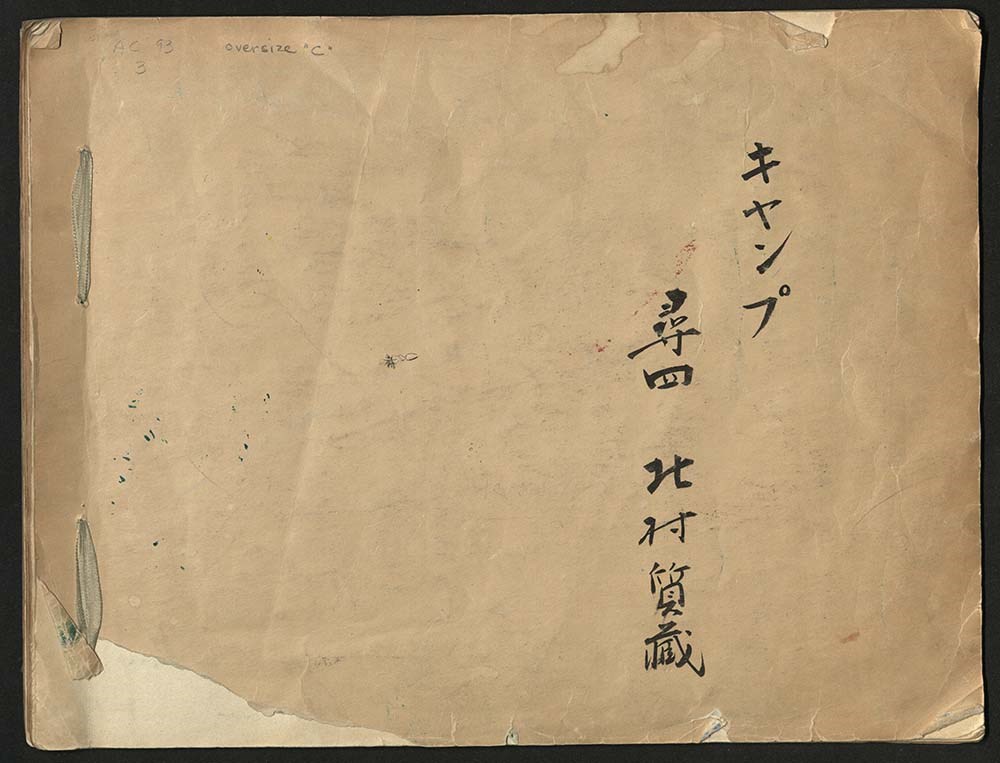
Japanese Sketchbook
https://archives.whyte.org/en/permalink/descriptions54789
- Part Of
- Alpine Club of Canada fonds
- Scope & Content
- File consists of a sketchbook containing Japanese writing, hand-drawn maps, and illustrations. Many of the illustrations are done in either watercolour paint or crayon.
- Date Range
- [ca. 1950-1960]
- Reference Code
- M200 / AC 093M / 2
- Description Level
- 5 / File
- GMD
- Scrapbook
- Painting
1 image
1 Electronic Resource
- Part Of
- Alpine Club of Canada fonds
- Description Level
- 5 / File
- Fonds Number
- M200 / S6 / V14
- Series
- I.A.1.b. Administration: general
- Sous-Fonds
- AC 093M
- Accession Number
- .
- Reference Code
- M200 / AC 093M / 2
- Date Range
- [ca. 1950-1960]
- Physical Description
- 0.5 cm of textual records (30 pages ; 37.5 x 28.5 cm)
- History / Biographical
- See fonds level description.
- Scope & Content
- File consists of a sketchbook containing Japanese writing, hand-drawn maps, and illustrations. Many of the illustrations are done in either watercolour paint or crayon.
- Name Access
- Alpine Club of Canada
- Subject Access
- Art
- Arts and crafts
- Backpacking
- Calligraphy
- Climbing
- Club
- Environment and Nature
- Painting
- Map
- Mountaineering
- Mountaineers
- Language
- Japanese
- Title Source
- Title based on material
- Processing Status
- Processed
Electronic Resources
Images
This material is presented as originally created; it may contain outdated cultural descriptions and
potentially offensive content.
Read more.
Jasper Trails Project - clippings
https://archives.whyte.org/en/permalink/descriptions56155
- Part Of
- Ben Gadd fonds
- Scope & Content
- File consists of eight newspaper articles from the Jasper Booster, pertaining to the Jasper Trails Project.
- Date Range
- 1997
- Reference Code
- M590 / III / D / 108
- Description Level
- 5 / File
- GMD
- Textual record
- Newspaper clipping
- Published record
- Part Of
- Ben Gadd fonds
- Description Level
- 5 / File
- Fonds Number
- M590
- V810
- S61
- Series
- M590 / III : Published records
- Sous-Fonds
- M590
- Sub-Series
- M590 / III / D : Other contracts and projects
- Accession Number
- 2021.20
- Reference Code
- M590 / III / D / 108
- Date Range
- 1997
- Physical Description
- 0.1 cm of textual records
- Scope & Content
- File consists of eight newspaper articles from the Jasper Booster, pertaining to the Jasper Trails Project.
- Name Access
- Gadd, Ben
- Subject Access
- Organization
- Trails
- Research
- Map
- Environment
- Hiking
- Recreation
- Parks Canada
- Government
- Newspaper
- Publication
- Geographic Access
- Canada
- Alberta
- Jasper
- Jasper National Park
- Reproduction Restrictions
- Restrictions may apply
- Language
- English
- Title Source
- Title based on contents of file
- Processing Status
- Processed
This material is presented as originally created; it may contain outdated cultural descriptions and
potentially offensive content.
Read more.
- Part Of
- Malcolm Geddes fonds
- Scope & Content
- File consists of two lantern slide photographs of western and eastern Canadian national parks maps.
- Date Range
- [ca.1925]
- Reference Code
- V756 / III / A / PS - 231 and 232
- Description Level
- 5 / File
- GMD
- Photograph
- Lantern slide
- Map
- Part Of
- Malcolm Geddes fonds
- Description Level
- 5 / File
- Fonds Number
- M39
- V756
- Series
- V756 / III : Personal and family records
- Sous-Fonds
- V756
- Sub-Series
- V756 / III / A : Travel and mountain expeditions
- Accession Number
- 6504
- Reference Code
- V756 / III / A / PS - 231 and 232
- Date Range
- [ca.1925]
- Physical Description
- 2 photographs : lantern slides
- Scope & Content
- File consists of two lantern slide photographs of western and eastern Canadian national parks maps.
- Material Details
- Lantern slides are hand-coloured
- Subject Access
- Map
- Geography
- National parks and reserves
- Travel
- Geographic Access
- Canada
- Access Restrictions
- Fragile - restrictions may apply
- Language
- N/A
- Category
- Exploration, discovery and travel
- Title Source
- Title based on contents of file
- Processing Status
- Processed
This material is presented as originally created; it may contain outdated cultural descriptions and
potentially offensive content.
Read more.
- Part Of
- Murray Hay fonds
- Scope & Content
- File consists of 4 maps, 2 prints, and 3 paintings, 60 x 30 cm or smaller. File pertains to a variety of maps Murray Hay created for Equinox Magazine in the 1980s. File includes original paintings (Middle East, Jamaica, North Atlantic Ocean/Europe area), two reproduced prints (South Korea Olympic a…
- Date Range
- ca.1980-ca.1989
- Reference Code
- V795 / II / D / ii / 4-6
- Description Level
- 5 / File
- GMD
- Painting
- Private record
- Map
- Part Of
- Murray Hay fonds
- Description Level
- 5 / File
- Fonds Number
- M570 / V795
- Series
- V795 / II : Unpublished Material
- Sous-Fonds
- V795
- Sub-Series
- V795 / II / D : International / ii : Miscellaneous
- Accession Number
- 2019.41
- 2020.03
- Reference Code
- V795 / II / D / ii / 4-6
- Date Range
- ca.1980-ca.1989
- Physical Description
- 4 maps (4 overlays) : col., annotations
- 2 prints : col. ; 36 x 28 cm
- 3 paintings ; 60 x 30 cm or smaller
- Scope & Content
- File consists of 4 maps, 2 prints, and 3 paintings, 60 x 30 cm or smaller. File pertains to a variety of maps Murray Hay created for Equinox Magazine in the 1980s. File includes original paintings (Middle East, Jamaica, North Atlantic Ocean/Europe area), two reproduced prints (South Korea Olympic area), and other maps (coloured red) with overlays (Nepal and the Caribbean).
- Notes
- Items not in oversize stored in downstairs vault.
- Name Access
- Hay, Murray
- Subject Access
- Advertising
- Artist
- Map
- Cartography
- Tourism
- Tourist information
- Travel
- Geography
- Olympic Games (Winter)
- Geographic Access
- South Korea
- Nepal
- Caribbean
- Mexico
- Belize
- Jamaica
- Europe
- Canada
- Middle East
- India
- Russia
- Language
- English
- Creator
- Hay, Murray
- Category
- Arts
- Exploration, discovery and travel
- Title Source
- Title based on contents of file
- Processing Status
- Processed
This material is presented as originally created; it may contain outdated cultural descriptions and
potentially offensive content.
Read more.