Narrow Results By
Trail Riders of the Canadian Rockies fonds
https://archives.whyte.org/en/permalink/descriptions14160
- Scope & Content
- Fonds consists of organizational records including photographs, brochures, correspondence and other documents which are divided into five series [see Content Details]. Content pertains to the Trail Riders of the Canadian Rockies, including the organization's history, members and staff, trail rides …
- Date Range
- [ca.1924]-2013
- Reference Code
- M545 / V635
- Description Level
- 1 / Fonds
- GMD
- Photograph
- Album
- Negative
- Photograph print
- Transparency
- Film
- Motion picture
- Textual record
- Organization record
- Published record
- Description Level
- 1 / Fonds
- Fonds Number
- M545 / V635
- Sous-Fonds
- M545
- V635
- Accession Number
- 5757
- 5939
- 8235
- 2014.8277
- 2022.22
- Reference Code
- M545 / V635
- GMD
- Photograph
- Album
- Negative
- Photograph print
- Transparency
- Film
- Motion picture
- Textual record
- Organization record
- Published record
- Responsibility
- Trail Riders of the Canadian Rockies
- Date Range
- [ca.1924]-2013
- Physical Description
- ca.340 cm of textual records -- 1191 photographs (691 prints, 312 transparencies, 188 negatives) -- 11 photograph albums -- 4 motion pictures -- 7 discs (1,214 digital images, 1 slideshow)
- History / Biographical
- The Trail Riders of the Canadian Rockies is a trail riding organization based in Calgary, Alberta. The organization was established in 1923 with the support of the Canadian Pacific Railway. The first ride was held in 1924, and annual summer trail rides and pow-wows attracted fifteen hundred members by 1929. Many notable residents of the Bow Valley, including members of the Brewster and Moore families, Catherine Robb and Peter Whyte, and Carl Rungius have participated in trail rides. Support from the Canadian Pacific Railway ended in 1961. As of 2020, the Trail Riders of the Canadian Rockies remains an active organization. LISTING OF TRAIL RIDE LOCATIONS: 1924 : Yoho Valley 1925 : Marble Canyon, Wolverine Plateau, Goodsir Plateau, Lake O'Hara, Lake Wapta, Sun Dance Lodge 1926 : Baker Lake, Shaki, Molar Peak, Bow Lake, Mosquito Creek, Ptarmigan Valley 1927 : Mountain Assiniboine, Brewster Creek, Magag Lake, Sunshine Camp, Simpson Pass; Jasper, Portal Creek, Maccarib Pass, Tonquin Valley, Meadow Creek, Calendone River 1928 : Lake of Hanging Glaciers; Horse Thief Creek, Windermere 1929 : Egypt Lake, Shadow Lake, Twin Lake; Lake Louise, Columbia Icefields 1930 : Red Earth Creek, Hawk Creek, Floe Lake, Wolverine Pass, Marble Canyon 1931 : Bankhead, Cascade River, Stewart Canyon, Stoney Creek, Baker Creek, Sawback Lake 1932 : Mount Assiniboine and Banff Springs Hotel terrace (Pow-wow) 1933 : Mosquito Creek, Bow Lake, Isabella Lake, Pipestone River, Lake Louise 1934 : Leanchoil, Shining Beauty camp, Goodsir mountain, Wolverine Plateau, Marble Canyon 1935 : Windy Camp, Snow Creek Pass, Scotch Cabin, Baker Lake, Ptarmigan Valley, Lake Louise Station (pow-wow) 1936 : Johnston Canyon, Pulsatilla Mountain, Badger Pass, Forty Mile Creek, Hillsdale Meadows 1937 : Mount Assiniboine, Lake Magog, Valley of the Rocks, Simpson Pass, Healy Creek 1938 : Carrot Creek, Lake Minnewanka, Middle Lake, Devil Gap, Ghost River, Mount Aylmer, Aylmer Pass 1939 : Healy Creek, Egypt Lake, Scarab Lake, Shadow Lakes, Twin Lakes, Taylor Lake, Moraine Lake 1940 : Marble Canyon, Helmet Creek, Ottertail River, Lake McArthur, Chateau Lake Louise 1941 : Mount Assiniboine, Canmore, spray Lakes, Valley of Rocks, Simpson Summit, Rock Isle Lake, Healy Creek 1942 : Larix Lake, Egypt Lake, Twin Lakes, Storm Mountain 1943 : Healy Creek warden's cabin, Brewater Creek, Fatigue Pass, Quartz hill, Simpson Summit, Sunshine Lodge, Eohippus lake, Mount Assiniboine 1944 : Healy Creek, Brewster Creek, Quartz Hill, Lake Eohippus, Red Earth Creek 1945 : Baker Lake 1946 : Panther River (Windy Camp), Snow Creek, Harrison Lake, Panther Falls 1947 : Monard Mountain, Healy Creek, Redearth Creek 1948 : Sunshine and Simpson River 1949 : Molar Mountain area 1950 : Palliser Pass 1951 : Goodsirs 1952 : Harvey Pass, Healy Creek, Egypt Lake 1953 : Baker Lakes 1954 : Mount Assiniboine, Magog Lake 1955 : Pulsatilla Pass area 1956 : Pipestone area 1957 : Panther River, Windy Camp, Dormer Pass, Snow Creek 1958 : Mount Assiniboine 1959 : Palliser Pass area [Bunny Robinson paints new teepee designs] 1960 : Pipestone area, north of Lake Louise 1961 : Goodsirs Mountains, McArthur Creek, Wolverine Pass [Volume 102, CPR publication last issue - CPR pulls sponsorship of association] 1962 : Pipestone and Skoki Valley areas 1963 : Simpson Summit, Healy Creek, Harvey Pass, Egypt Lake 1964 : Bryant Creek Meadows, Mount Assiniboine 1965 : Palliser Pass 1966 : Ptarmigan Valley, north of Lake Louise 1967 : Palliser Pass 1968 : Bryant Creek Meadows, Mount Assiniboine 1969 : Pulsatilla Pass 1970 : Egypt Lake area 1971 : Pipestone region 1972 : Shadow Lakes 1973 : Palliser Pass [50th anniversary] 1974 : Pulsatilla Pass area, Johnson Creek Meadows 1975 : Pipestone River area : Molar Glacier, Skoki Lakes, Merlin Lakes, hector Plateau, Fish Lakes 1976 : Cascade Valley region : Elk Lake summit, Stoney Creek, Dormer Pass 1977 : Mount Assiniboine 1978 : Palliser Pass area : Upper Spray River 1979 : Pulsatilla Pass area : Indian Paint Pots, Johnston Creek Meadows 1980 : Panther River region 1981 : Red Deer River region : Divide Creek, Tyrell Creek, Horseshoe Lake, Panther Ridge 1982 : Bryant Creek, Og Pass, Owl and Marvel Lakes, Allenby Pass, Assiniboine Pass, Lake Magog 1983 : Upper Pipestone River region: Red Deer Lake, Skoki Lakes, Hector Plateau, Singing Meadows [60th Anniversary] 1984 : Panther River region 1985 : Palliser Pass : Goat Ridge, Tumble Creek Falls, Spray Lakes, Birdwood Mountain, Leman Lake, White Man Pass 1986 : Johnston Creek, Badger Pass and Pulsatilla Pass; Safari expeditions: Kananaskis Country, Pipestone River , Front Range, Clearwater, Kootenay Plains 1987 : Red Deer River 1988 : Pipestone River 1989 : Panther River 1990 : Palliser Pass 1991 : Red Deer River 1992 : Bryant Creek 1993 : Pipestone River 1994 : Johnston Creek 1995 : Palliser Pass 1996 : Red Deer River 1997 : Bryant Creek 1998 : Panther River 1999 : Pipestone River 2000 : Johnston Creek 2001 : Palliser Pass 2002 : Yamnuska and Ghost Mountain 2003 : Bryant Creek 2004 : Cascade Valley and Mystic Lake 2005 : Sundance and Halfway Lodge 2006 : Waterton Park 2007 : Clearwater River 2008 : Kananaskis 2009 : Johnston Creek 2010 : Stoney Creek and Flint's Valley 2011 : Rock Lake and Solomon Creek 2012 : Kananaskis 2013 : Bryant Creek
- Scope & Content
- Fonds consists of organizational records including photographs, brochures, correspondence and other documents which are divided into five series [see Content Details]. Content pertains to the Trail Riders of the Canadian Rockies, including the organization's history, members and staff, trail rides and other events, publications and advertising, finances, and administration.
- Notes
- Fonds has been reorganized by Processing Archivist Kate Skelton and content from all accessions prior to 2019 has been integrated into new series. Content from accessions 5757 and 5939 have been renumbered; storage of files adjusted to accommodate most recent donations [accn. 8235 & accn. 2014.8277]
- Some files contain personal contact information including full names, home addresses, email addresses and phone numbers [see file-level entries under M545/V635 for specific contents and restrictions]
- Material Details
- Textual records include oversize items
- Name Access
- Trail Riders of the Canadian Rockies
- Subject Access
- Exploration, discovery and travel
- Sports, recreation and leisure
- Administration
- Advertising
- Organizations
- Membership
- Businesses
- Pack trips
- Tourism
- Travel
- Legal and Financial
- Geographic Access
- Canada
- Alberta
- Banff
- Calgary
- Edmonton
- Canadian Rocky Mountains
- Access Restrictions
- Copyright and privacy restrictions may apply
- Reproduction Restrictions
- Copyright and privacy restrictions may apply
- Language
- English
- Finding Aid
- Arrangement outline, series description and file descriptions available. Online file inventory available
- Related Material
- Fonds was accompanied by non-annotated print material (transferred to library)
- Category
- Sports, recreation and leisure
- Exploration, discovery and travel
- Communications
- Government
- Natural resources
- Transportation
- Biographical Source Notes
- http://trailridevacations.com/history/?gclid=Cj0KCQjw0pfzBRCOARIsANi0g0sZ6TMtMbL992rp2rhrDrJ-NkaD8zp5ceBIf_LJGHjYk3_lg_l4zrIaAs3oEALw_wcB
- Title Source
- Title based on contents of fonds
- Content Details
- Series I - Events and Activities: Records include ride notes and summaries [1968-2009], songs and poems performed during trail rides, documents and images pertaining to the Townsend Trophy photograph competition, and materials related to other events including trail ride anniversary events and round-ups. Series II - Members, Staff, Personal Content : Records include lists of trail ride participants, documents from camp coordinators and other trail ride staff, personal photographs, committee notes, personal correspondence and trail ride surveys from 1958-2009 Series III - Published Records : Records include newsletters, brochures, promotional material, news articles and other published content Series IV - Financial Records : Records include tax records, income statements, expense notes, receipts, payment information for members, budgets, price lists and funding applications Series V - Administrative Records : Records include administrative notes, inventories and checklists, meeting minutes and agendas, legal and administrative forms, and agreements with outfitting and supply companies
- Processing Status
- Processed
This material is presented as originally created; it may contain outdated cultural descriptions and
potentially offensive content.
Read more.
1964 ski trip, skiing with friends
https://archives.whyte.org/en/permalink/descriptions55310
- Part Of
- Chic Scott fonds
- Scope & Content
- File consists of photographs pertaining to Hans Gmoser skiing with friends. Most photographs are from a 1964 ski trip between Toby Creek and the Bugaboos mountain range in British Columbia.
- Date Range
- 1964
- [1980 - 1990]
- Reference Code
- V40 / V / PA - 1 to 24
- Description Level
- 5 / File
- Part Of
- Chic Scott fonds
- Description Level
- 5 / File
- Fonds Number
- M57
- S47
- V40
- Series
- V40 / V : Deep Powder and Steep Rock
- Sous-Fonds
- V40
- Accession Number
- 2015.8559
- Reference Code
- V40 / V / PA - 1 to 24
- Date Range
- 1964
- [1980 - 1990]
- Physical Description
- 24 photographs : b&w and col. prints; 25 x 20 cm or smaller
- Scope & Content
- File consists of photographs pertaining to Hans Gmoser skiing with friends. Most photographs are from a 1964 ski trip between Toby Creek and the Bugaboos mountain range in British Columbia.
- Notes
- Photographs in file are accompanied by one page of handwritten notes pertaining to details of images from 1964 ski trip [PA - 1 to 21] and one copy of an Eaton's newspaper ad featuring an illustration of a ski jumper
- Name Access
- Gmoser, Hans
- McConkey, Jim
- Wiegele, Mike
- Grillmair, Leo
- Gertsch, Rudy
- Gmoser, Margaret
- Lemire, Pierre
- Subject Access
- Sports
- Recreation
- Skiing
- Ski jumping
- Mountains
- Landscapes
- Family and personal life
- Exploration
- Travel
- Winter
- Winter sports
- Geographic Access
- Canada
- British Columbia
- Toby Creek
- Bugaboos
- Canadian Rocky Mountains
- Reproduction Restrictions
- Restrictions may apply
- Language
- English
- Title Source
- Title based on contents of file
- Processing Status
- Processed
This material is presented as originally created; it may contain outdated cultural descriptions and
potentially offensive content.
Read more.
Abbot Pass and Mount Geikie ascent
https://archives.whyte.org/en/permalink/descriptions55238
- Part Of
- Malcolm Geddes fonds
- Scope & Content
- File consists of 5 b&w photographs pertaining to the 1924 ascent of Mount Geikie and a hike through Abbot Pass. Includes group images of Malcolm Geddes, Harry Pollard, T.B. Moffat, Alvin Geddes, and various unidentified members of the Alpine Club of Canada.
- Date Range
- [1922 - 1927]
- 1924
- Reference Code
- V756 / III / A / PA - 20 to 24
- Description Level
- 5 / File
- GMD
- Photograph
- Photograph print
- Part Of
- Malcolm Geddes fonds
- Description Level
- 5 / File
- Fonds Number
- M39
- V756
- Series
- V756 / III : Personal and family records
- Sous-Fonds
- V756
- Sub-Series
- V756 / III / A : Travel and mountain expeditions
- Accession Number
- 2015.8558
- Reference Code
- V756 / III / A / PA - 20 to 24
- Date Range
- [1922 - 1927]
- 1924
- Physical Description
- 5 photographs : b&w prints ; 18 x 24 cm or smaller
- Scope & Content
- File consists of 5 b&w photographs pertaining to the 1924 ascent of Mount Geikie and a hike through Abbot Pass. Includes group images of Malcolm Geddes, Harry Pollard, T.B. Moffat, Alvin Geddes, and various unidentified members of the Alpine Club of Canada.
- Notes
- Items are annotated on back
- Material Details
- One print is attached to a partial sheet of graph paper
- Name Access
- Geddes, Malcolm
- Pollard, Harry
- Moffat, Thomas B.
- Geddes, Alvin
- Subject Access
- Climbing
- Exploration
- Hiking
- Mountaineering
- Mountains
- Recreation
- Sports
- Summit
- Geographic Access
- Canada
- Alberta
- Abbot Pass
- British Columbia
- Mount Geikie
- Reproduction Restrictions
- Restrictions may apply
- Language
- English
- Conservation
- Items are stored in mylar
- Title Source
- Title based on contents of file
- Processing Status
- Processed
This material is presented as originally created; it may contain outdated cultural descriptions and
potentially offensive content.
Read more.
Auyuittuq National Park
https://archives.whyte.org/en/permalink/descriptions54979
- Part Of
- Murray Hay fonds
- Scope & Content
- File consists of 1 painting : landscape ; 50.5 x 39.5 cm. File pertains to a map Murray Hay created of Auyuittuq National Park in Nunavut, Canada. File includes 1 colour painting of the park and surrounding area (Nunavut, Baffin Island) and one sheet of tracing paper that is annotated and taped wit…
- Date Range
- ca.1980-ca.1989
- Reference Code
- V795 / II / C / vi / 1
- Description Level
- 5 / File
- GMD
- Map
- Painting
- Private record
- Part Of
- Murray Hay fonds
- Description Level
- 5 / File
- Fonds Number
- M570 / V795
- Series
- V795 / II : Unpublished Material
- Sous-Fonds
- V795
- Sub-Series
- V795 / II / C : Canada [general] / vi : Auyuittuq National Park
- Accession Number
- 2020.03
- Reference Code
- V795 / II / C / vi / 1
- Date Range
- ca.1980-ca.1989
- Physical Description
- 1 painting : landscape ; 50.5 x 39.5 cm
- Scope & Content
- File consists of 1 painting : landscape ; 50.5 x 39.5 cm. File pertains to a map Murray Hay created of Auyuittuq National Park in Nunavut, Canada. File includes 1 colour painting of the park and surrounding area (Nunavut, Baffin Island) and one sheet of tracing paper that is annotated and taped with masking tape over the painting.
- Name Access
- Hay, Murray
- Subject Access
- Advertising
- Artist
- Map
- Cartography
- Painting
- Geography
- Tourism
- Tourist information
- Travel
- National parks and reserves
- Auyuittuq National Park
- Geographic Access
- Auyuittuq National Park
- Nunavut
- Canada
- Language
- English
- Conservation
- Masking tape should be removed and alternative preservation methods should be considered at a reasonable time to do so.
- Creator
- Hay, Murray
- Title Source
- Title based on contents of file
- Processing Status
- Processed
This material is presented as originally created; it may contain outdated cultural descriptions and
potentially offensive content.
Read more.
Banff National Park (general)
https://archives.whyte.org/en/permalink/descriptions55338
- Part Of
- Murray Hay fonds
- Scope & Content
- File consists of 4 prings : col. 35.1 x 24.8 cm or smaller and 4 maps (2 paper, 2 overlays) : col., on mylar ; 60.4 x 30. cm or smaller. File pertains to aerial views of Banff National Park, showing the towns of Banff and Lake Louise, ski hills (Norqay Ski Hill, Sunshine Village, and Lake Louise Sk…
- Date Range
- ca.1976-ca.2000
- Reference Code
- V795 / II / B / v / 1-2
- Description Level
- 5 / File
- GMD
- Map
- Private record
- Part Of
- Murray Hay fonds
- Description Level
- 5 / File
- Fonds Number
- M570 / V795
- Series
- V795 / II : Unpublished Material
- Sous-Fonds
- V795
- Sub-Series
- V795 / II / B : Alberta / v : Banff National Park
- Accession Number
- 2019.41
- Reference Code
- V795 / II / B / v / 1-2
- GMD
- Map
- Private record
- Date Range
- ca.1976-ca.2000
- Physical Description
- 4 prints : col. 35.1 x 24.8 cm or smaller
- 4 maps (2 paper, 2 overlays) : col., annotations, on mylar ; 60.4 x 30. cm or smaller
- Scope & Content
- File consists of 4 prings : col. 35.1 x 24.8 cm or smaller and 4 maps (2 paper, 2 overlays) : col., on mylar ; 60.4 x 30. cm or smaller. File pertains to aerial views of Banff National Park, showing the towns of Banff and Lake Louise, ski hills (Norqay Ski Hill, Sunshine Village, and Lake Louise Ski Resort), as well as other georgraphic features. The mylar overlays contain various amounts of detail and annotations - one consists of a dark red sheet overlayed with place names in negative.
- Notes
- Items not in oversize stored in downstairs vault.
- Name Access
- Hay, Murray
- Subject Access
- Advertising
- Artist
- Ski Maps
- Map
- Cartography
- Sports and recreation
- Tourism
- Tourist information
- Winter
- Winter sports
- Ski area
- Sunshine Village
- Norquay Ski Hill
- Lake Louise Ski Area
- Geographic Access
- Banff
- Lake Louise
- Banff National Park
- Alberta
- Canada
- Canadian Rocky Mountains
- Language
- English
- Creator
- Hay, Murray
- Title Source
- Title based on contents of file
- Processing Status
- Processed
This material is presented as originally created; it may contain outdated cultural descriptions and
potentially offensive content.
Read more.
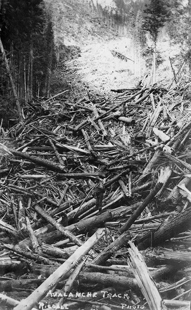
Bert Riggall's 1000 Mile Pack trip
https://archives.whyte.org/en/permalink/descriptions23454
- Part Of
- Bert Riggall fonds
- Scope & Content
- File consists of 43 b&w photographs, some captioned. Photographs pertain to Riggall's 1911 1000 mile pack trip undertaken to seek out areas for hunting and outfitting following the enlargement of Waterton National Park and the reduction of available hunting area for Riggall's clients. The prints do…
- Date Range
- 1911
- Reference Code
- V26 / II / A7 / PA - 119 to 161
- Description Level
- 5 / File
- GMD
- Photograph
- Photograph print
1 image
- Part Of
- Bert Riggall fonds
- Description Level
- 5 / File
- Fonds Number
- M376 / V26
- Series
- II.Business and Financial: Bert Riggall's 1000 Mile Pack trip, 1911
- Sous-Fonds
- V26
- Accession Number
- 7201
- Reference Code
- V26 / II / A7 / PA - 119 to 161
- Date Range
- 1911
- Physical Description
- 43 photographs: b&w prints
- Scope & Content
- File consists of 43 b&w photographs, some captioned. Photographs pertain to Riggall's 1911 1000 mile pack trip undertaken to seek out areas for hunting and outfitting following the enlargement of Waterton National Park and the reduction of available hunting area for Riggall's clients. The prints document this pack trip from stops in Banff, AB and Cranbrook, BC, and the extent of his mountain exploration from Fort Steele to Edson. On this trip, approximately 150 miles of new trail was cut including portions of Roger's Pass.
- Subject Access
- Pack trips
- Exploration
- Trails
- Trail making
- Recreation
- Hunting
- Outfitters, trail guides and packers
- Geographic Access
- Canada
- Alberta
- Banff National Park
- Waterton National Park
- British Columbia
- Cranbrook
- Rogers Pass
- Language
- English
- Title Source
- Title based on contents of file
- Processing Status
- Processed
Images

This material is presented as originally created; it may contain outdated cultural descriptions and
potentially offensive content.
Read more.
Bert Riggall's 1000 Mile Pack trip
https://archives.whyte.org/en/permalink/descriptions23455
- Part Of
- Bert Riggall fonds
- Scope & Content
- File consists of 20 b&w photographs, some captioned. Photographs pertain to Riggall's 1911 1000 mile pack trip undertaken to seek out areas for hunting and outfitting following the enlargement of Waterton National Park and the reduction of available hunting area for Riggall's clients. The prints do…
- Date Range
- 1911
- Reference Code
- V26 / II / A7 / PA - 162 to 181
- Description Level
- 5 / File
- GMD
- Photograph
- Photograph print
1 image
- Part Of
- Bert Riggall fonds
- Description Level
- 5 / File
- Fonds Number
- M376 / V26
- Series
- II.Business and Financial: Bert Riggall's 1000 Mile Pack trip, 1911
- Sous-Fonds
- V26
- Accession Number
- 7201
- Reference Code
- V26 / II / A7 / PA - 162 to 181
- Date Range
- 1911
- Physical Description
- Photographs: 20 prints, b&w
- Scope & Content
- File consists of 20 b&w photographs, some captioned. Photographs pertain to Riggall's 1911 1000 mile pack trip undertaken to seek out areas for hunting and outfitting following the enlargement of Waterton National Park and the reduction of available hunting area for Riggall's clients. The prints document this pack trip from stops in Banff, AB and Cranbrook, BC, and the extent of his mountain exploration from Fort Steele to Edson. On this trip, approximately 150 miles of new trail was cut including portions of Roger's Pass.
- Subject Access
- Pack trips
- Exploration
- Trails
- Trail making
- Recreation
- Hunting
- Outfitters, trail guides and packers
- Geographic Access
- Canada
- Alberta
- Banff National Park
- Waterton National Park
- British Columbia
- Cranbrook
- Rogers Pass
- Language
- English
- Title Source
- Title based on contents of file
- Processing Status
- Processed
Images
This material is presented as originally created; it may contain outdated cultural descriptions and
potentially offensive content.
Read more.
Big White Ski Village
https://archives.whyte.org/en/permalink/descriptions54801
- Part Of
- Murray Hay fonds
- Scope & Content
- File consists of 0.5 cm of textual records, 90 x 60.5 cm. File pertains to ski trail maps of Big White Ski Village and Area created by Murray Hay. File includes one oversized published reproduction of a Big White trail map in poster format.
- Date Range
- ca.1980 - ca.2000
- Reference Code
- M570 / III / A / v / 1
- Description Level
- 5 / File
- GMD
- Map
- Poster
- Published record
- Textual record
- Part Of
- Murray Hay fonds
- Description Level
- 5 / File
- Fonds Number
- M570 / V795
- Series
- M570 / III : Murray Hay portfolio (published material)
- Sous-Fonds
- M570
- Sub-Series
- M570 / III / A : British Columbia / v : Big White
- Accession Number
- 2019.41
- Reference Code
- M570 / III / A / v / 1
- Date Range
- ca.1980 - ca.2000
- Physical Description
- 0.5 cm of textual records (90 x 60.5 cm)
- Scope & Content
- File consists of 0.5 cm of textual records, 90 x 60.5 cm. File pertains to ski trail maps of Big White Ski Village and Area created by Murray Hay. File includes one oversized published reproduction of a Big White trail map in poster format.
- Name Access
- Hay, Murray
- Subject Access
- Ski Maps
- Map
- Ski area
- Skiing
- Tourism
- Travel
- Winter
- Winter sports
- Sports and recreation
- Big White Ski Area
- Tourist information
- Artist
- Advertising
- Geographic Access
- Kelowna
- British Columbia
- Canada
- Language
- English
- Related Material
- V795 / II / A / iv / 5
- Title Source
- Title based on contents of file
- Processing Status
- Processed
This material is presented as originally created; it may contain outdated cultural descriptions and
potentially offensive content.
Read more.
Bow Valley area, mountain ranges and views
https://archives.whyte.org/en/permalink/descriptions55530
- Part Of
- Luxton family fonds
- Scope & Content
- File consists of 34 photographs depicting views of the Bow Valley and surrounding areas, and Quebec. Depicted locations include Chinaman's Peak (now Ha Ling), End Mountain, Fairholme Range, Mount McDougall, Mount Chester, Mount Galatea, Fisher Range in Kananaskis, Mount Lougheed and Mount Sparrowha…
- Date Range
- 1938-1939
- Reference Code
- LUX / III / D / PA - 171 to 204
- Description Level
- 5 / File
- GMD
- Photograph
- Part Of
- Luxton family fonds
- Description Level
- 5 / File
- Fonds Number
- LUX
- Series
- LUX / III / D : Other material
- Sous-Fonds
- LUX / III : Luxton family sous-fonds
- Accession Number
- LUX
- Reference Code
- LUX / III / D / PA - 171 to 204
- GMD
- Photograph
- Date Range
- 1938-1939
- Physical Description
- 34 photographs : b&w prints ; 11 x 7 cm
- Scope & Content
- File consists of 34 photographs depicting views of the Bow Valley and surrounding areas, and Quebec. Depicted locations include Chinaman's Peak (now Ha Ling), End Mountain, Fairholme Range, Mount McDougall, Mount Chester, Mount Galatea, Fisher Range in Kananaskis, Mount Lougheed and Mount Sparrowhawk in Alberta; and the Laurentian Mountains and St Adele (Quebec).
- Notes
- Some photographs are individually captioned with locations, dates and other related information
- Subject Access
- Exploration
- Travel
- Mountains
- Landscapes
- Environment
- Hiking
- Recreation
- Summit
- Geographic Access
- Canada
- Alberta
- Bow Valley
- Kananaskis
- Quebec
- Reproduction Restrictions
- Copyright status unknown
- Language
- English
- Conservation
- Items stored in mylar
- Title Source
- Title based on contents of file
- Processing Status
- Processed
This material is presented as originally created; it may contain outdated cultural descriptions and
potentially offensive content.
Read more.
Brochure production
https://archives.whyte.org/en/permalink/descriptions54929
- Scope & Content
- File consists of notes, clippings and drafts of brochures to be published by the Trail Riders of the Canadian Rockies. File also includes several illustrations of trail maps to be included in brochures, correspondence pertaining to brochure production, model release forms and three duplicate b&w pr…
- Date Range
- 1980-1985
- Reference Code
- M545 / V / 29 & 30
- Description Level
- 5 / File
- GMD
- Textual record
- Published record
- Organization record
- Description Level
- 5 / File
- Fonds Number
- M545 / V635
- Series
- M545 / V : Administrative records
- Sous-Fonds
- M545
- Accession Number
- 5939
- Reference Code
- M545 / V / 29 & 30
- Date Range
- 1980-1985
- Physical Description
- 2.5 cm of textual records (21.5 x 28 cm or smaller) -- 3 photographs : b&w prints ; 9 x 9 cm
- Scope & Content
- File consists of notes, clippings and drafts of brochures to be published by the Trail Riders of the Canadian Rockies. File also includes several illustrations of trail maps to be included in brochures, correspondence pertaining to brochure production, model release forms and three duplicate b&w prints depicting several trail riders on horseback [image used in 1980 brochure].
- Notes
- Six "Holiday on Horseback" brochures removed from file. Items are duplicates of brochures processed in series M545 / II and will be offered for return to Trail Riders of the Canadian Rockies.
- File contents organized by date and stored in two folders [see "Content Details"]
- Subject Access
- Administration
- Advertising
- Tourism
- Travel
- Organizations
- Membership
- Businesses
- Geography
- Horse packing
- Horseback riding
- Trails
- Hotels
- Geographic Access
- Canada
- Alberta
- Calgary
- Banff
- Language
- English
- Conservation
- Prints placed in mylar and stored in folder with related textual material to preserve context
- Category
- Exploration, discovery and travel
- Sports, recreation and leisure
- Communications
- Commerce and industry
- Title Source
- Title based on contents of file
- Processing Status
- Processed
This material is presented as originally created; it may contain outdated cultural descriptions and
potentially offensive content.
Read more.