Narrow Results By
Comparison of sedimentation regimes in four glacier-fed lakes of Western Alberta
https://archives.whyte.org/en/permalink/catalogue7273
- Medium
- Library - Book (including soft-cover and pamphlets)
- Author
- Smith, Norman D
- Call Number
- 03.5 Sm6cs Pam
- Author
- Smith, Norman D
- Responsibility
- Norman D. Smith, Mark A. Vendl and Stephen K. Kennedy
- Physical Description
- p.203-237 : maps
- Subjects
- Bow Lake
- Hector Lake
- Peyto Lake
- Waterfowl Lakes
- Notes
- From Research in Glacial, Glaciofluvial, and Glacio-lacustrine Systems : Proceedings of the 6th Guelph Symposium on Geomorphology, 1980
- Bibliography
- Accession Number
- 3726
- Call Number
- 03.5 Sm6cs Pam
- Collection
- Archives Library
This material is presented as originally created; it may contain outdated cultural descriptions and
potentially offensive content.
Read more.
Geological map of Hector Lake area, east half
https://archives.whyte.org/en/permalink/catalogue24702
- Medium
- Library - Book (including soft-cover and pamphlets)
- Map
- Published Date
- 1978
- Publisher
- Geological Survey of Canada
- Call Number
- C7-1.12(b)
- Publisher
- Geological Survey of Canada
- Published Date
- 1978
- Scale
- 1:50,000
- Subjects
- Hector Lake
- B.N.P.
- Notes
- Map 1463A
- Accession Number
- 11,000
- Call Number
- C7-1.12(b)
- Collection
- Archives Library
This material is presented as originally created; it may contain outdated cultural descriptions and
potentially offensive content.
Read more.
Geological map of Hector Lake area, west half
https://archives.whyte.org/en/permalink/catalogue24703
- Medium
- Library - Book (including soft-cover and pamphlets)
- Map
- Published Date
- 1978
- Publisher
- Geological Survey of Canada
- Call Number
- C7-1.12(c)
- Publisher
- Geological Survey of Canada
- Published Date
- 1978
- Scale
- 1:50,000
- Subjects
- Hector Lake
- B.N.P.
- Notes
- Map 1464A
- Accession Number
- 11,000
- Call Number
- C7-1.12(c)
- Collection
- Archives Library
This material is presented as originally created; it may contain outdated cultural descriptions and
potentially offensive content.
Read more.
Glaciolacustrine sedimentation and holocene glacial history, Northern Banff National Park, Alberta
https://archives.whyte.org/en/permalink/catalogue5556
- Medium
- Library - Book (including soft-cover and pamphlets)
- Published Date
- 1983
- Author
- Leonard, Eric Michael
- Publisher
- Ann Arbor (MI) : University Microfilms
- Call Number
- 03.4 L55
- Author
- Leonard, Eric Michael
- Publisher
- Ann Arbor (MI) : University Microfilms
- Published Date
- 1983
- Physical Description
- xiv, 271p. : ill., maps
- Subjects
- Bow Lake
- Crowfoot Lake
- Hector Lake
- Notes
- Thesis (Ph.D.),University of Colorado, 1981
- Bibliography
- Accession Number
- 16000
- Call Number
- 03.4 L55
- Collection
- Archives Library
This material is presented as originally created; it may contain outdated cultural descriptions and
potentially offensive content.
Read more.
[Hector Lake]
https://archives.whyte.org/en/permalink/catalogue21455
- Medium
- Library - Book (including soft-cover and pamphlets)
- Map
- Published Date
- 1978
- Publisher
- Geological Survey of Canada
- Call Number
- C7-1.12(a)
- Publisher
- Geological Survey of Canada
- Published Date
- 1978
- Subjects
- Hector Lake
- B.N.P.
- Notes
- Diagrammatic structure of geological maps of the Hector Lake area, east half (Map 1463A) and west half (Map 1464A)
- Accession Number
- 11,000
- Call Number
- C7-1.12(a)
- Collection
- Archives Library
This material is presented as originally created; it may contain outdated cultural descriptions and
potentially offensive content.
Read more.
[Hector Lake 82 N/9 East - Alberta-B.C.]
https://archives.whyte.org/en/permalink/catalogue23655
- Medium
- Library - Maps and blueprints (unannotated; published)
- Map
- Published Date
- 1961
- Publisher
- Dept. of Mines and Technical Surveys
- Call Number
- NTS
- 82N/9E
- Publisher
- Dept. of Mines and Technical Surveys
- Published Date
- 1961
- Physical Description
- Colour
- Scale
- Scale: 1:50,000
- Relief: Contour interval 100'
- Notes
- National Topographic System
- Accession Number
- 6283 (duplicate)
- Call Number
- NTS
- 82N/9E
- Collection
- Archives Library
This material is presented as originally created; it may contain outdated cultural descriptions and
potentially offensive content.
Read more.
[Hector Lake 82 N/9 West - Alberta-B.C.]
https://archives.whyte.org/en/permalink/catalogue23656
- Medium
- Library - Maps and blueprints (unannotated; published)
- Map
- Published Date
- 1961
- Publisher
- Dept. of Mines and Technical Surveys
- Call Number
- NTS
- 82N/9W
- Publisher
- Dept. of Mines and Technical Surveys
- Published Date
- 1961
- Physical Description
- Colour
- Scale
- Scale: 1:50,000
- Relief: Contour interval 100'
- Notes
- National Topographic System
- Accession Number
- 6283 (duplicate)
- Call Number
- NTS
- 82N/9W
- Collection
- Archives Library
This material is presented as originally created; it may contain outdated cultural descriptions and
potentially offensive content.
Read more.
Hector Lake, Alberta-British Columbia
https://archives.whyte.org/en/permalink/catalogue23654
- Medium
- Library - Maps and blueprints (unannotated; published)
- Map
- Published Date
- 1979
- Publisher
- [Ottawa] : Surveys and Mapping Branch, Dept. of Energy, Mines and Resources
- Edition
- 2d ed.
- Call Number
- NTS
- 82N/9
- Edition
- 2d ed.
- Publisher
- [Ottawa] : Surveys and Mapping Branch, Dept. of Energy, Mines and Resources
- Published Date
- 1979
- Physical Description
- 1 map : col
- Scale
- 1:50,000
- Subjects
- Hector Lake (Alta./B.C.)
- Accession Number
- 27,000
- Call Number
- NTS
- 82N/9
- Collection
- Archives Library
This material is presented as originally created; it may contain outdated cultural descriptions and
potentially offensive content.
Read more.
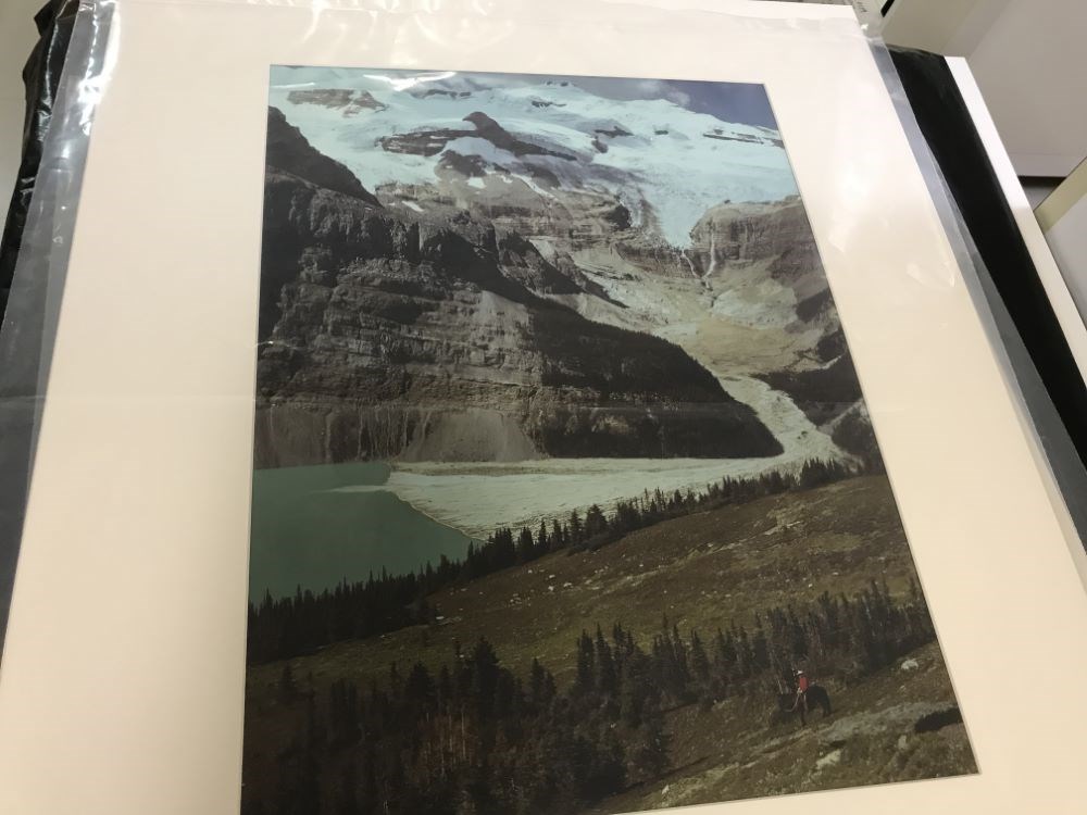
Mount Balfour and Hector Lake
https://archives.whyte.org/en/permalink/artifactmon.18.03
- Date
- 1947
- Medium
- cibachrome on paper
- Catalogue Number
- MoN.18.03
- Description
- A colour photograph, the snow and glacier covered Mount Burgess dominates the picture, the lake is a green colour at the left centre, in the foreground the valley floor is green and angles down from the right centre to the left, a horseback rider with a red shirt is in the lower right of the picture
1 image
- Title
- Mount Balfour and Hector Lake
- Date
- 1947
- Medium
- cibachrome on paper
- Dimensions
- 57.7 x 42.0 cm
- Description
- A colour photograph, the snow and glacier covered Mount Burgess dominates the picture, the lake is a green colour at the left centre, in the foreground the valley floor is green and angles down from the right centre to the left, a horseback rider with a red shirt is in the lower right of the picture
- Credit
- Purchased from Nicholas Morant, Banff, 1985
- Catalogue Number
- MoN.18.03
Images
This material is presented as originally created; it may contain outdated cultural descriptions and
potentially offensive content.
Read more.
The relationship between carbonate mineralogy and grain size in two alpine lakes
https://archives.whyte.org/en/permalink/catalogue7214
- Medium
- Library - Book (including soft-cover and pamphlets)
- Author
- Kennedy, Stephen K
- Call Number
- 03.5 K38 Pam
- Author
- Kennedy, Stephen K
- Responsibility
- by Stephen K. Kennedy and Norman D. Smith
- Physical Description
- p.411-418 : map
- Subjects
- Bow Lake
- Hector Lake
- Limnology
- Notes
- From Journal of Sedimentary Petrology, vol.47, no.1, March 1977
- Accession Number
- 2482
- 3051
- Call Number
- 03.5 K38 Pam
- Collection
- Archives Library
This material is presented as originally created; it may contain outdated cultural descriptions and
potentially offensive content.
Read more.