Narrow Results By
- Belmore Browne (1880 – 1954, American) 2
- Department of the Interior: Dominion of Canada 2
- Monachello, Placido 2
- Ambrosi, Joey 1
- Bennett, Miriam F 1
- Bern Smith (1928 – 2009, Canadian) 1
- Cameron, Donald 1
- Charles Morrise Brousson ( – 1941) 1
- Colclough, Albert 1
- Corbett, Beatrice 1
- Ferguson, H. L 1
- George Weber (1907 – 2002, Canadian) 1
Geology and structure cross-section : Ovington Creek, British Columbia (93/12)
https://archives.whyte.org/en/permalink/catalogue24753
- Medium
- Library - Book (including soft-cover and pamphlets)
- Map
- Published Date
- 1995
- Author
- McMechan, M.E.
- Publisher
- Ottawa : Geological Survey of Canada
- Call Number
- C7-3.24
- Author
- McMechan, M.E.
- Responsibility
- M.E. McMechan and R.I. Thompson
- Publisher
- Ottawa : Geological Survey of Canada
- Published Date
- 1995
- Physical Description
- 1 map : col
- Scale
- 1:50,000
- Notes
- (Map 1873A)
- Accession Number
- 29,000
- Call Number
- C7-3.24
- Collection
- Archives Library
This material is presented as originally created; it may contain outdated cultural descriptions and
potentially offensive content.
Read more.
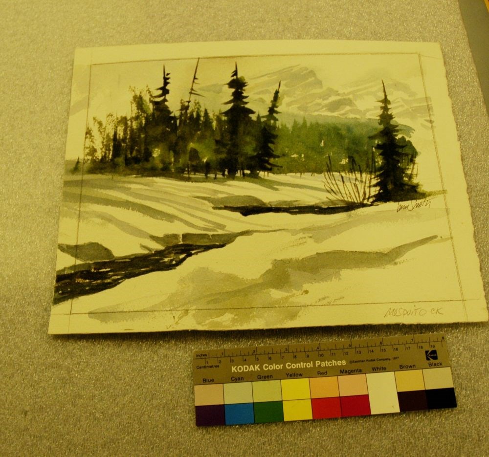
Mosquito Creek
https://archives.whyte.org/en/permalink/artifactsmb.05.04
- Date
- 2009
- Medium
- watercolour on paper
- Catalogue Number
- SmB.05.04
- Description
- A winter scene with dominant colours of white, green, blue, grey, and black. The foreground, which is more than half the painting, is comprised of snow, ice, shadows, two sections of the creek starting from viewer’s left, with one bush and one coniferous tree to viewer’s far middle right. The dark …
1 image
- Title
- Mosquito Creek
- Date
- 2009
- Medium
- watercolour on paper
- Dimensions
- 30.0 x 36.7 cm
- Description
- A winter scene with dominant colours of white, green, blue, grey, and black. The foreground, which is more than half the painting, is comprised of snow, ice, shadows, two sections of the creek starting from viewer’s left, with one bush and one coniferous tree to viewer’s far middle right. The dark water of the creek is visible from the bush at the right, flows under the ice and snow, and then reappears at the left-hand centre of the painting and flows to the viewer’s left hand corner of the painting. The top-third of the painting is a bank of coniferous trees, sparsely painted on the left, becoming larger and darker towards middle and then lighter on the right as the trees further back rise to the mountain range in the background. Snow and clouds obscure the mountain tops. The sky is light grey and white.
- Credit
- Purchased from Brett Smith, 108 Mile Ranch, 2009
- Catalogue Number
- SmB.05.04
Images
This material is presented as originally created; it may contain outdated cultural descriptions and
potentially offensive content.
Read more.
Preliminary map: George Creek, Alberta
https://archives.whyte.org/en/permalink/catalogue24729
- Medium
- Library - Book (including soft-cover and pamphlets)
- Map
- Published Date
- 1940
- Author
- MacKay, B.R.
- Publisher
- Ottawa: Mines and Geological Branch
- Call Number
- C7-2.13, C7-2.13a
- Author
- MacKay, B.R.
- Publisher
- Ottawa: Mines and Geological Branch
- Published Date
- 1940
- Physical Description
- 2 maps
- Scale
- Scale: 1 inch = 1/2 mile
- Notes
- Paper 40-17
- Accession Number
- 5000
- Call Number
- C7-2.13, C7-2.13a
- Collection
- Archives Library
This material is presented as originally created; it may contain outdated cultural descriptions and
potentially offensive content.
Read more.
Ptarmigan Creek : west half : British Columbia
https://archives.whyte.org/en/permalink/catalogue24748
- Medium
- Library - Book (including soft-cover and pamphlets)
- Map
- Published Date
- 1990
- Author
- McDonough, M.R.
- Publisher
- Ottawa: Geological Survey of Canada
- Call Number
- C7-3.19
- Author
- McDonough, M.R.
- Publisher
- Ottawa: Geological Survey of Canada
- Published Date
- 1990
- Scale
- Scale: ca. 1:50,000
- Notes
- 83D10
- Accession Number
- 24,000
- Call Number
- C7-3.19
- Collection
- Archives Library
This material is presented as originally created; it may contain outdated cultural descriptions and
potentially offensive content.
Read more.
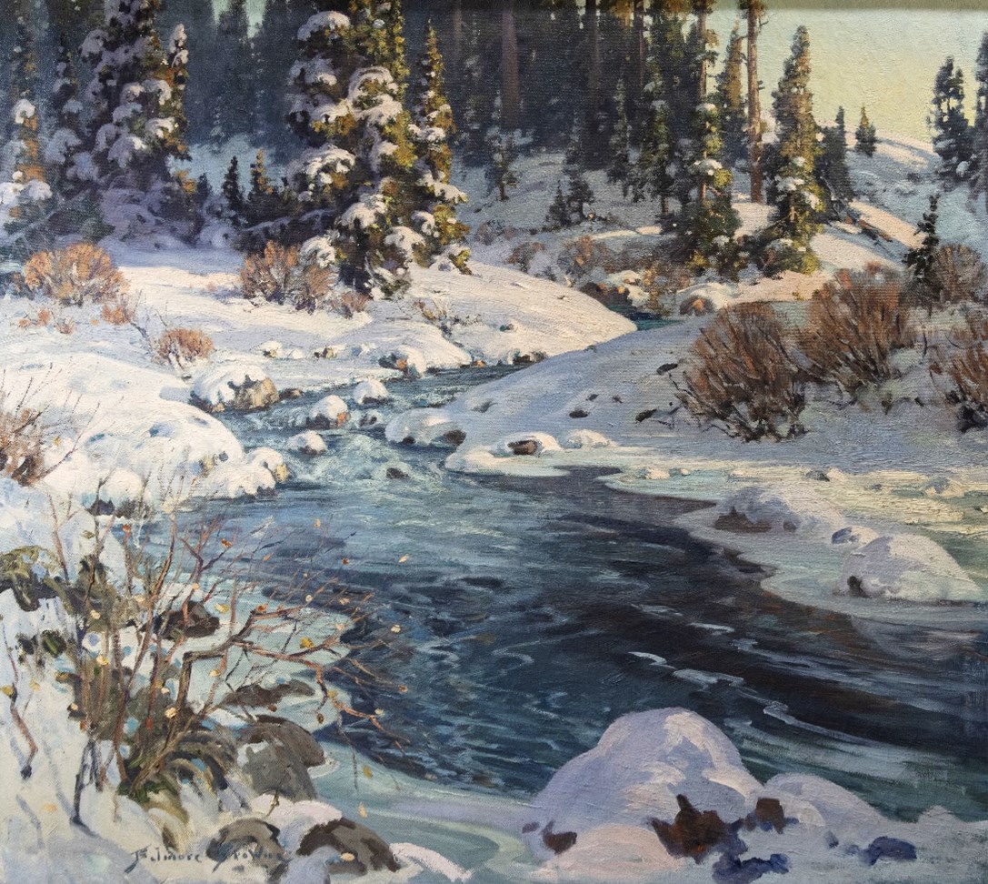
- Date
- c. 1930
- Medium
- oil on canvas
- Catalogue Number
- BwB.02.01
- Description
- General colour: blue, purple, green. Creek is surrounded on all sides by snow covered rocks and shrubs. The water comes down from the upper right of center to the lower center and of right near the bottom. In the lower left corner is a bare branched bush. Across the top is snow covered evergreens. …
1 image
- Title
- Baker Creek
- Date
- c. 1930
- Medium
- oil on canvas
- Dimensions
- 90.2 x 100.2 cm
- Description
- General colour: blue, purple, green. Creek is surrounded on all sides by snow covered rocks and shrubs. The water comes down from the upper right of center to the lower center and of right near the bottom. In the lower left corner is a bare branched bush. Across the top is snow covered evergreens. Clear sky and a distant hill in the upper right corner.
- Subject
- landscape
- Canadian Rockies
- winter
- Baker Creek
- Credit
- Gift of Evelyn Browne, Durham, USA, 1968
- Catalogue Number
- BwB.02.01
Images
This material is presented as originally created; it may contain outdated cultural descriptions and
potentially offensive content.
Read more.
[Blue Creek 83E/7 East, Alta.]
https://archives.whyte.org/en/permalink/catalogue23503
- Medium
- Library - Maps and blueprints (unannotated; published)
- Map
- Published Date
- 1960
- Publisher
- Dept. of Mines and Techinical Surveys
- Call Number
- NTS
- 83E/7E
- Publisher
- Dept. of Mines and Techinical Surveys
- Published Date
- 1960
- Physical Description
- 1 map : col
- Scale
- Scale: 1: 50,000
- Relief: Contour Interval 100 feet
- Subjects
- Blue Creek
- Eastern Alberta
- Notes
- National Topographic System
- Accession Number
- 3000
- Call Number
- NTS
- 83E/7E
- Collection
- Archives Library
This material is presented as originally created; it may contain outdated cultural descriptions and
potentially offensive content.
Read more.
[Blue Creek 83E/7 West, Alta.]
https://archives.whyte.org/en/permalink/catalogue23504
- Medium
- Library - Maps and blueprints (unannotated; published)
- Map
- Published Date
- 1960
- Publisher
- Dept. of Mines and Techinical Surveys
- Call Number
- NTS
- 83E/7W
- Publisher
- Dept. of Mines and Techinical Surveys
- Published Date
- 1960
- Physical Description
- 1 map : col
- Scale
- Scale: 1:50,000
- Relief: Contour Interval 100 ft.
- Subjects
- Blue Creek
- Western Alberta
- Notes
- National Topographic System
- Accession Number
- 3000
- Call Number
- NTS
- 83E/7W
- Collection
- Archives Library
This material is presented as originally created; it may contain outdated cultural descriptions and
potentially offensive content.
Read more.
[Bluewater Creek, B.C.]
https://archives.whyte.org/en/permalink/catalogue23509
- Medium
- Library - Maps and blueprints (unannotated; published)
- Map
- Published Date
- 1980
- Publisher
- Dept. of Energy, Mines and Resources
- Edition
- Edition 2
- Call Number
- NTS
- 82N/11
- Edition
- Edition 2
- Publisher
- Dept. of Energy, Mines and Resources
- Published Date
- 1980
- Physical Description
- 1 map : col
- Scale
- Scale: 1:50,000
- Relief: Contour Interval 100 ft.
- Subjects
- Bluewater Creek
- British Columbia
- Notes
- National Topographic System
- Accession Number
- 12,000
- 7030
- Call Number
- NTS
- 82N/11
- Collection
- Archives Library
This material is presented as originally created; it may contain outdated cultural descriptions and
potentially offensive content.
Read more.
Bluewater Creek, Kootenay Land District, British Columbia
https://archives.whyte.org/en/permalink/catalogue23508
- Medium
- Library - Maps and blueprints (unannotated; published)
- Map
- Publisher
- Nepean (Ont.) : Canada Map Office, 1996
- Edition
- 3d ed.
- Call Number
- NTS
- 82N/11
- Edition
- 3d ed.
- Publisher
- Nepean (Ont.) : Canada Map Office, 1996
- Physical Description
- 1 map : col
- Scale
- Scale: 1:50,000
- Subjects
- Bluewater Creek
- British Columbia
- Notes
- Information current as of 1994
- Accession Number
- 29,000
- Call Number
- NTS
- 82N/11
- Collection
- Archives Library
This material is presented as originally created; it may contain outdated cultural descriptions and
potentially offensive content.
Read more.
[Bolton Creek, Alberta]
https://archives.whyte.org/en/permalink/catalogue23511
- Medium
- Library - Maps and blueprints (unannotated; published)
- Map
- Publisher
- Dept. of Mines & Technical Survey
- Call Number
- NTS
- 83L/2E
- Publisher
- Dept. of Mines & Technical Survey
- Scale
- Scale: 1:50,000
- Subjects
- Bolton Creek
- Alberta
- Notes
- National Topographic System
- Accession Number
- 12000
- Call Number
- NTS
- 83L/2E
- Collection
- Archives Library
This material is presented as originally created; it may contain outdated cultural descriptions and
potentially offensive content.
Read more.