Narrow Results By
- McIntyre, David 5
- Geological Survey of Canada 4
- Alberta. Environment Conservation Authority 3
- Lampard, Robert 3
- Alberta Tourism and Small Business 2
- Anderson, Frank 2
- Field, Dorothy 2
- O'Hagan, Howard 2
- Seager, Allen 2
- Alberta Society of Petroleum Geologists 1
- Alberta Society of Petroleum Geologists. Annual Field Conference, 12th (Calgary?) 1962 1
- Ambrosi, Joey 1
The Crow and the Kettle
https://archives.whyte.org/en/permalink/catalogue13159
- Medium
- Library - Book (including soft-cover and pamphlets)
- Author
- Garden, John F
- Publisher
- Cowley (Alberta) : Footprint Publishing
- Call Number
- 08.5 G16c
- Author
- Garden, John F
- Publisher
- Cowley (Alberta) : Footprint Publishing
- Physical Description
- 312 p. : ill., maps
- Subjects
- Canadian Pacific Railway
- Crowsnest Pass
- Notes
- Pertains to the CPR in southern British Columbia and Alberta 1950-1969 : Lethbridge, Kootenay and Kettle Valley divisions and the change from steam to diesel power
- ISBN
- 0-9691621-8-9
- Accession Number
- 39000
- Call Number
- 08.5 G16c
- Collection
- Archives Library
This material is presented as originally created; it may contain outdated cultural descriptions and
potentially offensive content.
Read more.

The Crows Nest Railway
https://archives.whyte.org/en/permalink/catalogue12584
- Author
- Harvey, R.G
- Physical Description
- p.17-22 : ill., map
- Medium
- Library - Periodical
- Notes
- In British Columbia Historical News, vol. 37, no.3 (Summer 2004)
- Call Number
- P
- Collection
- Archives Library
This material is presented as originally created; it may contain outdated cultural descriptions and
potentially offensive content.
Read more.
[Crowsnest 82G/10 East, B.C.-Alberta]
https://archives.whyte.org/en/permalink/catalogue23570
- Medium
- Library - Maps and blueprints (unannotated; published)
- Map
- Published Date
- 1961
- Publisher
- Dept. of Mines and Technical Surveys
- Call Number
- NTS
- 82G/10E
- Publisher
- Dept. of Mines and Technical Surveys
- Published Date
- 1961
- Physical Description
- 1 map : col
- Scale
- Scale: 1:50,000
- Relief: Contour interval 100'
- Subjects
- Crowsnest
- British Columbia/Alberta
- Notes
- National Topographic System
- Call Number
- NTS
- 82G/10E
- Collection
- Archives Library
This material is presented as originally created; it may contain outdated cultural descriptions and
potentially offensive content.
Read more.
[Crowsnest 82G/10 West, B.C.-Alberta]
https://archives.whyte.org/en/permalink/catalogue23571
- Medium
- Library - Maps and blueprints (unannotated; published)
- Map
- Published Date
- 1961
- Publisher
- Dept. of Mines and Technical Surveys
- Call Number
- NTS
- 82G/10W
- Publisher
- Dept. of Mines and Technical Surveys
- Published Date
- 1961
- Physical Description
- 1 map : col
- Scale
- Scale: 1:50,000
- Relief: Contour interval 100'
- Subjects
- Crowsnest
- British Columbia/Alberta
- Notes
- National Topographic System
- Call Number
- NTS
- 82G/10W
- Collection
- Archives Library
This material is presented as originally created; it may contain outdated cultural descriptions and
potentially offensive content.
Read more.
Crowsnest, British Columbia-Alberta
https://archives.whyte.org/en/permalink/catalogue23569
- Medium
- Library - Maps and blueprints (unannotated; published)
- Map
- Published Date
- 1980
- Publisher
- Ottawa : Surveys and Mapping Branch, Dept. of Energy, Mines and Resources
- Edition
- 3d ed.
- Call Number
- NTS
- 82G/10
- Edition
- 3d ed.
- Publisher
- Ottawa : Surveys and Mapping Branch, Dept. of Energy, Mines and Resources
- Published Date
- 1980
- Physical Description
- 1 map : col
- Scale
- Scale: 1:50,000
- Subjects
- Crowsnest
- British Columbia-Alberta
- Accession Number
- 27000
- Call Number
- NTS
- 82G/10
- Collection
- Archives Library
This material is presented as originally created; it may contain outdated cultural descriptions and
potentially offensive content.
Read more.
[Crowsnest Forest Reserve]
https://archives.whyte.org/en/permalink/catalogue23241
- Medium
- Library - Maps and blueprints (unannotated; published)
- Map
- Published Date
- 1962 (Revised 1968)
- Publisher
- Dept. of Lands and Forests
- Call Number
- C2-11.3
- Publisher
- Dept. of Lands and Forests
- Published Date
- 1962 (Revised 1968)
- Physical Description
- 1 map : col
- Scale
- Scale: 1 inch : 3 miles
- Altitude tints
- Subjects
- Crowsnest Forest Reserve
- Accession Number
- 3000
- Call Number
- C2-11.3
- Collection
- Archives Library
This material is presented as originally created; it may contain outdated cultural descriptions and
potentially offensive content.
Read more.
Crowsnest Lake: last gem of the Canadian Rockies
https://archives.whyte.org/en/permalink/catalogue12915
- Author
- Janusz, Barbara
- Physical Description
- p.20-22 : ill
- Medium
- Library - Periodical
- Subjects
- Crowsnest Pass
- Development
- Notes
- In Wild Lands Advocate, vol.14, no.1 (February 2006)
- Call Number
- P
- Collection
- Archives Library
This material is presented as originally created; it may contain outdated cultural descriptions and
potentially offensive content.
Read more.
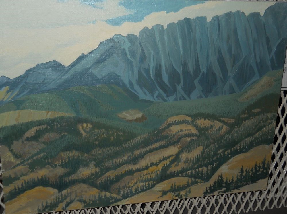
Crowsnest Pass
https://archives.whyte.org/en/permalink/artifactagg.02.01
- Date
- c. 1984
- Medium
- oil on linen
- Catalogue Number
- AgG.02.01
- Description
- Off in the distance is wall of blue mountains. Darker blue areas on the mountains represent the tree line. In the middle and foreground are rolling areas of yellow land separated by rows and lines of dark green trees. The sky is covered in white clouds with bits of blue showing through.
1 image
- Title
- Crowsnest Pass
- Date
- c. 1984
- Medium
- oil on linen
- Dimensions
- 46.0 x 61.0 cm
- Description
- Off in the distance is wall of blue mountains. Darker blue areas on the mountains represent the tree line. In the middle and foreground are rolling areas of yellow land separated by rows and lines of dark green trees. The sky is covered in white clouds with bits of blue showing through.
- Subject
- landscape
- Canadian Rockies
- Crowsnest Pass
- Credit
- Gift of Kay Angliss, Penticton, 1998
- Catalogue Number
- AgG.02.01
Images
This material is presented as originally created; it may contain outdated cultural descriptions and
potentially offensive content.
Read more.
Cumulative effects study fills gap in South Eastern Slopes planning
https://archives.whyte.org/en/permalink/catalogue13184
- Author
- Douglas, Nigel
- Physical Description
- p.13-14 : ill., map
- Medium
- Library - Periodical
- Subjects
- Crowsnest Pass
- Oldman River
- Notes
- In Wild Lands Advocate, vol.14, no.5 (October 2006)
- Call Number
- P
- Collection
- Archives Library
This material is presented as originally created; it may contain outdated cultural descriptions and
potentially offensive content.
Read more.
- Date
- 1960 – 1985
- Material
- ceramic
- Catalogue Number
- 104.20.1061 a,b
- Description
- A matched cup and sauder that each have gold trim along the edges. Both are decorated with a picture of Crowsnest Mountain and “CROWSNEST MT. 9138 FT.” and the cup also has a picture of two crows atop a post marked “Crowsnest Pass” alongside the sign for the town of Blairmore, Alberta. The botto…
1 image
- Title
- Cup And Saucer
- Date
- 1960 – 1985
- Material
- ceramic
- Description
- A matched cup and sauder that each have gold trim along the edges. Both are decorated with a picture of Crowsnest Mountain and “CROWSNEST MT. 9138 FT.” and the cup also has a picture of two crows atop a post marked “Crowsnest Pass” alongside the sign for the town of Blairmore, Alberta. The bottom of the cup is marked with a crown and “Royal Ascot Bone China 43 MADE IN ENGLAND EXCLUSIVELY FOR R. M. Crabb.”
- Subject
- households
- souvenirs
- Crowsnest Pass
- mountains
- birds
- crows
- Credit
- Gift of Jon Whyte, Banff, 1985
- Catalogue Number
- 104.20.1061 a,b
Images

This material is presented as originally created; it may contain outdated cultural descriptions and
potentially offensive content.
Read more.