Narrow Results By
Hand drawn map of Windermere region, poem
https://archives.whyte.org/en/permalink/descriptions57577
- Part Of
- Archives General File Collection
- Scope & Content
- File consists of one hand-drawn map by Roger Ruck (1915-1953) depicting Windermere and surrounding regions. A poem pertaining to Roger's early life in England is written on the back.
- Date Range
- [ca.1935 - 1940]
- Reference Code
- M8 / accn. 2023.48
- Description Level
- 5 / File
- GMD
- Textual record
- Map
- Part Of
- Archives General File Collection
- Description Level
- 5 / File
- Fonds Number
- M8
- V8
- S8
- Sous-Fonds
- M8
- Accession Number
- 2023.48
- Reference Code
- M8 / accn. 2023.48
- GMD
- Textual record
- Map
- Responsibility
- Produced by Roger Ruck
- Date Range
- [ca.1935 - 1940]
- Physical Description
- 1 map : hand-drawn black ink ; 11 x 21 cm
- History / Biographical
- See V8 / accn. 2023.48 / PA - 1 to 5
- See accession record
- Scope & Content
- File consists of one hand-drawn map by Roger Ruck (1915-1953) depicting Windermere and surrounding regions. A poem pertaining to Roger's early life in England is written on the back.
- Material Details
- Map and poem drawn/written in black ink
- Name Access
- Ruck, Roger
- Subject Access
- Geography
- Map
- Poetry
- Exploration
- Travel
- Geographic Access
- Canada
- British Columbia
- Windermere
- Access Restrictions
- No restrictions
- Reproduction Restrictions
- No restrictions
- Language
- English
- Related Material
- V8 / accn. 2023.48 / PA - 1 to 5
- Category
- Exploration and travel
- Title Source
- Title based on contents of file
- Processing Status
- Processed
This material is presented as originally created; it may contain outdated cultural descriptions and
potentially offensive content.
Read more.
Topographical maps
https://archives.whyte.org/en/permalink/descriptions56805
- Part Of
- Ben Gadd fonds
- Scope & Content
- Sub-sub series consists of topographical maps depicting various regions in Canada and the United States, which were collected by Ben Gadd. Includes ca.13 maps of regions in the United States (including Eagletail National Park in Arizona, Colorado Springs, and Montana); and ca.213 maps of regions in…
- Date Range
- [ca.1960-2005]
- Reference Code
- M590 / I / A / ii
- Description Level
- 4.1 / Sub-sub-series
- GMD
- Map
- Part Of
- Ben Gadd fonds
- Description Level
- 4.1 / Sub-sub-series
- Fonds Number
- M590
- V810
- S61
- Series
- M590 / I : Personal records
- Sous-Fonds
- M590
- Sub-Series
- M590 / I / A / ii : Travel guides and maps : Topographical maps
- Accession Number
- 2021.20
- Reference Code
- M590 / I / A / ii
- GMD
- Map
- Date Range
- [ca.1960-2005]
- Physical Description
- ca.226 topographical maps
- Scope & Content
- Sub-sub series consists of topographical maps depicting various regions in Canada and the United States, which were collected by Ben Gadd. Includes ca.13 maps of regions in the United States (including Eagletail National Park in Arizona, Colorado Springs, and Montana); and ca.213 maps of regions in Northern Canada, Western Canada and the Canadian Rockies (predominantly Alberta and British Columbia, as well as the Yukon).
- Notes
- Some maps include annotations by Ben Gadd
- Name Access
- Gadd, Ben
- Geographic Access
- Canada
- Alberta
- British Columbia
- Yukon
- Canadian Rocky Mountains
- Rocky Mountains
- Reproduction Restrictions
- Restrictions may apply
- Language
- English
- Category
- Exploration and travel
- Title Source
- Title based on contents of file
- Processing Status
- Processed
This material is presented as originally created; it may contain outdated cultural descriptions and
potentially offensive content.
Read more.
Travel guides and pocket maps
https://archives.whyte.org/en/permalink/descriptions56806
- Part Of
- Ben Gadd fonds
- Scope & Content
- Sub-sub-series consists of ca.30 travel maps and guides collected by Ben Gadd, primarily pertaining to regions in the United States. Includes regions in Colorado, Arizona, British Columbia, Alberta and Saskatchewan.
- Date Range
- [ca.1970-2005]
- Reference Code
- M590 / I / A / i
- Description Level
- 4.1 / Sub-sub-series
- GMD
- Map
- Part Of
- Ben Gadd fonds
- Description Level
- 4.1 / Sub-sub-series
- Fonds Number
- M590
- V810
- S61
- Series
- M590 / I : Personal records
- Sous-Fonds
- M590
- Sub-Series
- M590 / I / A / i : Travel guides and pocket maps
- Accession Number
- 2021.20
- Reference Code
- M590 / I / A / i
- GMD
- Map
- Date Range
- [ca.1970-2005]
- Physical Description
- ca.30 travel guides and maps
- Scope & Content
- Sub-sub-series consists of ca.30 travel maps and guides collected by Ben Gadd, primarily pertaining to regions in the United States. Includes regions in Colorado, Arizona, British Columbia, Alberta and Saskatchewan.
- Name Access
- Gadd, Ben
- Geographic Access
- Canada
- Alberta
- British Columbia
- Saskatchewan
- Canadian Rocky Mountains
- United States of America
- Colorado
- Arizona
- Reproduction Restrictions
- Restrictions may apply
- Language
- English
- Title Source
- Title based on contents of file
- Processing Status
- Processed
This material is presented as originally created; it may contain outdated cultural descriptions and
potentially offensive content.
Read more.
- Part Of
- Ben Gadd fonds
- Scope & Content
- Sub-sub-series consists of ca.50 maps of various regions in Western Canada and Alaska which were collected by Ben Gadd. Maps are arranged according to associated highways which the mapped regions depict.
- Date Range
- [ca.1970-2005]
- Reference Code
- M590 / I / A / iv
- Description Level
- 4.1 / Sub-sub-series
- GMD
- Map
- Part Of
- Ben Gadd fonds
- Description Level
- 4.1 / Sub-sub-series
- Fonds Number
- M590
- V810
- S61
- Series
- M590 / I : Personal records
- Sous-Fonds
- M590
- Sub-Series
- M590 / I / A / iv : Travel guides and maps : Highway maps
- Accession Number
- 2021.20
- Reference Code
- M590 / I / A / iv
- GMD
- Map
- Date Range
- [ca.1970-2005]
- Physical Description
- ca.50 maps -- 4 paper scans of maps
- Scope & Content
- Sub-sub-series consists of ca.50 maps of various regions in Western Canada and Alaska which were collected by Ben Gadd. Maps are arranged according to associated highways which the mapped regions depict.
- Notes
- Regions included in file: Highway 3 Highway 6 Highway 11 Highway 16 Highway 22 & 40 Highway 93 [To Jasper] Highway 93 [To Radium] Highway 97 [Pine Pass] Highway 97 [Alaska Highway]
- Name Access
- Gadd, Ben
- Geographic Access
- Canada
- Alberta
- British Columbia
- Canadian Rocky Mountains
- Alaska
- Reproduction Restrictions
- Restrictions may apply
- Language
- English
- Title Source
- Title based on contents of file
- Processing Status
- Processed
This material is presented as originally created; it may contain outdated cultural descriptions and
potentially offensive content.
Read more.
Travel guides and maps
https://archives.whyte.org/en/permalink/descriptions56361
- Part Of
- Ben Gadd fonds
- Scope & Content
- Sub-series consists of travel brochures and maps which were collected and used by Ben Gadd. Sub-series contains five sub-sub series: M590 / I / A / i : Travel guides and pocket maps M590 / I / A / ii : Topographical maps M590 / I / A / iii : Geological maps M590 / I / A / iv : Highway maps M590 / …
- Date Range
- [ca.1920-2010]
- Reference Code
- M590 / I / A
- Description Level
- 4 / Sub-series
- GMD
- Map
- Textual record
- Part Of
- Ben Gadd fonds
- Description Level
- 4 / Sub-series
- Fonds Number
- M590
- V810
- S61
- Series
- M590 / I : Personal records
- Sous-Fonds
- M590
- Sub-Series
- M590 / I / A : Travel guides and maps
- Accession Number
- 2021.20
- Reference Code
- M590 / I / A
- GMD
- Map
- Textual record
- Date Range
- [ca.1920-2010]
- Physical Description
- ca. 274 maps -- ca. 61 travel guides, brochures
- Scope & Content
- Sub-series consists of travel brochures and maps which were collected and used by Ben Gadd. Sub-series contains five sub-sub series: M590 / I / A / i : Travel guides and pocket maps M590 / I / A / ii : Topographical maps M590 / I / A / iii : Geological maps M590 / I / A / iv : Highway maps M590 / I / A / v : Index maps, other
- Notes
- Some materials in sub-series are annotated with notes by Ben Gadd
- Name Access
- Gadd, Ben
- Subject Access
- Geography
- Geology
- Environment
- Map
- Tourism
- Tourist information
- Travel
- Trails
- Roads
- Transportation
- Natural history
- National parks and reserves
- Provincial parks and reserves
- Government
- Sports
- Recreation
- Hiking
- Geographic Access
- Canada
- Alberta
- British Columbia
- Banff National Park
- Jasper National Park
- Kootenay National Park
- Yoho National Park
- Waterton Lakes National Park
- Columbia Icefields
- United States of America
- Colorado
- Montana
- Yellowstone National Park
- Access Restrictions
- Restrictions may apply - some materials are fragile
- Reproduction Restrictions
- Restrictions may apply
- Language
- English
- Conservation
- Some fragile/torn materials stored in mylar
- Category
- Environment
- Exploration, discovery and travel
- Government
- Sports, recreation and leisure
- Transportation
- Tourism
- Title Source
- Title based on contents of sub-series
- Processing Status
- Processed
This material is presented as originally created; it may contain outdated cultural descriptions and
potentially offensive content.
Read more.
University of Lethbridge geological map, colloquium study
https://archives.whyte.org/en/permalink/descriptions56330
- Part Of
- Ben Gadd fonds
- Scope & Content
- File consists of 12 copies of a geological map produced by Ben Gadd while completing a Colloquium Study program at the University of Lethbridge between 1970 and 1972. Map depicts a small region of the Canadian Rockies. File includes three clear [plastic?] copies; six paper copies; one negative prin…
- Date Range
- 1970-1972
- Reference Code
- M590 / I / B / 21
- Description Level
- 5 / File
- GMD
- Map
- Blueprint
- Part Of
- Ben Gadd fonds
- Description Level
- 5 / File
- Fonds Number
- M590
- V810
- S61
- Series
- M590 / I : Personal records
- Sous-Fonds
- M590
- Sub-Series
- M590 / I / B : Education and early writing
- Accession Number
- 2021.20
- Reference Code
- M590 / I / B / 21
- Responsibility
- Produced by Ben Gadd
- Date Range
- 1970-1972
- Physical Description
- 12 maps : 79 x 90 cm or smaller
- Scope & Content
- File consists of 12 copies of a geological map produced by Ben Gadd while completing a Colloquium Study program at the University of Lethbridge between 1970 and 1972. Map depicts a small region of the Canadian Rockies. File includes three clear [plastic?] copies; six paper copies; one negative print copy; and two blueprint copies.
- Name Access
- Gadd, Ben
- Subject Access
- Geography
- Geology
- Natural history
- Map
- Research
- Education
- University
- Geographic Access
- Canada
- Alberta
- Lethbridge
- Canadian Rocky Mountains
- Access Restrictions
- Restrictions may apply - request assistance from archival staff
- Reproduction Restrictions
- Restrictions may apply - request assistance from archival staff
- Language
- English
- Conservation
- Material transferred to archival map tube
- Related Material
- M590/I/B/17 to 20
- Category
- Education
- Title Source
- Title based on contents of file
- Processing Status
- Processed
This material is presented as originally created; it may contain outdated cultural descriptions and
potentially offensive content.
Read more.
Operation Bow-Athabasca exhibit
https://archives.whyte.org/en/permalink/descriptions56253
- Part Of
- Ben Gadd fonds
- Scope & Content
- File consists of correspondence, maps and other documents pertaining to the Operation Bow-Athabasca exhibit, which was displayed at the Canmore Museum and Geoscience Centre in 2012. File includes a programme for the opening of the exhibition; geological maps and other research materials; a quote fo…
- Date Range
- 1973
- 2010-2012
- Reference Code
- M590 / III / D / 117
- Description Level
- 5 / File
- GMD
- Textual record
- Published record
- Map
- Part Of
- Ben Gadd fonds
- Description Level
- 5 / File
- Fonds Number
- M590
- V810
- S61
- Series
- M590 / III : Professional records
- Sous-Fonds
- M590
- Sub-Series
- M590 / III / D : Other contracts and projects
- Accession Number
- 2021.20
- Reference Code
- M590 / III / D / 117
- Date Range
- 1973
- 2010-2012
- Physical Description
- 1.5 cm of textual records -- 4 maps
- Scope & Content
- File consists of correspondence, maps and other documents pertaining to the Operation Bow-Athabasca exhibit, which was displayed at the Canmore Museum and Geoscience Centre in 2012. File includes a programme for the opening of the exhibition; geological maps and other research materials; a quote for the production of display signs for the exhibit; Ben Gadd's personal notes pertaining to the exhibit; and other related materials.
- Name Access
- Gadd, Ben
- Subject Access
- Natural history
- Geology
- Environment
- Research
- Public events
- Community events
- Publication
- Museums
- Geographic Access
- Canada
- Alberta
- Canmore
- Reproduction Restrictions
- Restrictions may apply
- Language
- English
- Category
- Environment
- Title Source
- Title based on contents of file
- Processing Status
- Processed
This material is presented as originally created; it may contain outdated cultural descriptions and
potentially offensive content.
Read more.
Jasper Trails Project - map publishers
https://archives.whyte.org/en/permalink/descriptions56241
- Part Of
- Ben Gadd fonds
- Scope & Content
- File consists of correspondence sent between Ben Gadd and various map publishing companies, and samples of previously published maps and travel guides. Correspondence pertains to the production of trail maps which were designed by the Friends of Jasper National Park and Parks Canada as part of the …
- Date Range
- 1994
- 1996-1997
- Reference Code
- M590 / III / D / 114
- Description Level
- 5 / File
- GMD
- Textual record
- Published record
- Map
- Part Of
- Ben Gadd fonds
- Description Level
- 5 / File
- Fonds Number
- M590
- V810
- S61
- Series
- M590 / III : Published records
- Sous-Fonds
- M590
- Sub-Series
- M590 / III / D : Other contracts and projects
- Accession Number
- 2021.20
- Reference Code
- M590 / III / D / 114
- Date Range
- 1994
- 1996-1997
- Physical Description
- 0.5 cm of textual records
- Scope & Content
- File consists of correspondence sent between Ben Gadd and various map publishing companies, and samples of previously published maps and travel guides. Correspondence pertains to the production of trail maps which were designed by the Friends of Jasper National Park and Parks Canada as part of the Jasper Trails Project.
- Name Access
- Gadd, Ben
- Subject Access
- Organization
- Trails
- Map
- Environment
- Geography
- Parks Canada
- Government
- Tourist information
- Publication
- Businesses
- Geographic Access
- Canada
- Alberta
- Jasper
- Jasper National Park
- Reproduction Restrictions
- Restrictions may apply
- Language
- English
- Category
- Environment
- Government
- Title Source
- Title based on contents of file
- Processing Status
- Processed
This material is presented as originally created; it may contain outdated cultural descriptions and
potentially offensive content.
Read more.
Jasper Trails Project - printed trail maps
https://archives.whyte.org/en/permalink/descriptions56152
- Part Of
- Ben Gadd fonds
- Scope & Content
- File consists of printed drafts of trail maps depicting regions near Pyramid Bench, Maligne Canyon, Wabasso Lake and Miette River; and quotes from three printing companies in Alberta. Materials pertain to the updating of trail signage and interpretive information through the Jasper Trails Project.
- Date Range
- 1997-1998
- Reference Code
- M590 / III / D / 106
- Description Level
- 5 / File
- GMD
- Textual record
- Map
- Part Of
- Ben Gadd fonds
- Description Level
- 5 / File
- Fonds Number
- M590
- V810
- S61
- Series
- M590 / III : Published records
- Sous-Fonds
- M590
- Sub-Series
- M590 / III / D : Other contracts and projects
- Accession Number
- 2021.20
- Reference Code
- M590 / III / D / 106
- GMD
- Textual record
- Map
- Date Range
- 1997-1998
- Physical Description
- 0.2 cm of textual records
- Scope & Content
- File consists of printed drafts of trail maps depicting regions near Pyramid Bench, Maligne Canyon, Wabasso Lake and Miette River; and quotes from three printing companies in Alberta. Materials pertain to the updating of trail signage and interpretive information through the Jasper Trails Project.
- Subject Access
- Organization
- Trails
- Research
- Map
- Environment
- Hiking
- Recreation
- Geography
- Parks Canada
- Government
- Geographic Access
- Canada
- Alberta
- Jasper
- Jasper National Park
- Edmonton
- Reproduction Restrictions
- Restrictions may apply
- Language
- English
- Title Source
- Title based on contents of file
- Processing Status
- Processed
This material is presented as originally created; it may contain outdated cultural descriptions and
potentially offensive content.
Read more.
Jasper Trails Project - sign location maps
https://archives.whyte.org/en/permalink/descriptions56154
- Part Of
- Ben Gadd fonds
- Scope & Content
- File consists of maps showing the locations of interpretive signs which were updated and installed as part of the Jasper Trails Project. File includes film positive copies of maps, and related notes and correspondence.
- Date Range
- 1995
- 1997
- Reference Code
- M590 / III / D / 107
- Description Level
- 5 / File
- GMD
- Textual record
- Map
- Part Of
- Ben Gadd fonds
- Description Level
- 5 / File
- Fonds Number
- M590
- V810
- S61
- Series
- M590 / III : Published records
- Sous-Fonds
- M590
- Sub-Series
- M590 / III / D : Other contracts and projects
- Accession Number
- 2021.20
- Reference Code
- M590 / III / D / 107
- GMD
- Textual record
- Map
- Date Range
- 1995
- 1997
- Physical Description
- 1 cm of textual records
- Scope & Content
- File consists of maps showing the locations of interpretive signs which were updated and installed as part of the Jasper Trails Project. File includes film positive copies of maps, and related notes and correspondence.
- Subject Access
- Organization
- Trails
- Research
- Map
- Environment
- Hiking
- Recreation
- Geography
- Parks Canada
- Government
- Geographic Access
- Canada
- Alberta
- Jasper
- Jasper National Park
- Reproduction Restrictions
- Restrictions may apply
- Language
- English
- Title Source
- Title based on contents of file
- Processing Status
- Processed
This material is presented as originally created; it may contain outdated cultural descriptions and
potentially offensive content.
Read more.
Maligne Lake fact sheet
https://archives.whyte.org/en/permalink/descriptions56072
- Part Of
- Ben Gadd fonds
- Scope & Content
- File consists of documents pertaining to a fact sheet about Maligne Lake which Ben Gadd produced for Parks Canada while working as a Seasonal Naturalist in Jasper. File includes cropped sections of a map depicting Maligne Lake and surrounding areas; research and planning notes written by Ben; a pro…
- Date Range
- [ca.1980-1984]
- Reference Code
- M590 / III / A / 9
- Description Level
- 5 / File
- GMD
- Textual record
- Map
- Part Of
- Ben Gadd fonds
- Description Level
- 5 / File
- Fonds Number
- M590
- V810
- S61
- Series
- M590 / III : Professional records
- Sous-Fonds
- M590
- Sub-Series
- M590 / III / A : Parks Canada records
- Accession Number
- 2021.20
- Reference Code
- M590 / III / A / 9
- GMD
- Textual record
- Map
- Responsibility
- Produced by Ben Gadd
- Date Range
- [ca.1980-1984]
- Physical Description
- 0.2 cm of textual records
- Scope & Content
- File consists of documents pertaining to a fact sheet about Maligne Lake which Ben Gadd produced for Parks Canada while working as a Seasonal Naturalist in Jasper. File includes cropped sections of a map depicting Maligne Lake and surrounding areas; research and planning notes written by Ben; a prospectus/summary of the project; and a scanned paper copy of film strips depicting images of Maligne Lake.
- Name Access
- Gadd, Ben
- Subject Access
- Parks Canada
- Government
- Environment
- Landscape
- Geography
- Geological formation
- Geology
- Natural history
- Geographic Access
- Canada
- Alberta
- Maligne Lake
- Jasper National Park
- Reproduction Restrictions
- Restrictions may apply
- Language
- English
- Category
- Environment
- Government
- Title Source
- Title based on contents of file
- Processing Status
- Processed
This material is presented as originally created; it may contain outdated cultural descriptions and
potentially offensive content.
Read more.
Maligne Lake tear-off map
https://archives.whyte.org/en/permalink/descriptions56073
- Part Of
- Ben Gadd fonds
- Scope & Content
- File consists of documents pertaining to the creation of a tear-off map of Maligne Lake, which Ben Gadd produced for Parks Canada while working as a Seasonal Naturalist in Jasper. File includes a project proposal, textual drafts, visual layout samples, correspondence, invoices and other related mat…
- Date Range
- [ca.1980-1984]
- Reference Code
- M590 / III / A / 10
- Description Level
- 5 / File
- GMD
- Textual record
- Map
- Part Of
- Ben Gadd fonds
- Description Level
- 5 / File
- Fonds Number
- M590
- V810
- S61
- Series
- M590 / III : Professional records
- Sous-Fonds
- M590
- Sub-Series
- M590 / III / A : Parks Canada records
- Accession Number
- 2021.20
- Reference Code
- M590 / III / A / 10
- GMD
- Textual record
- Map
- Responsibility
- Produced by Ben Gadd
- Date Range
- [ca.1980-1984]
- Physical Description
- 1 cm of textual records
- Scope & Content
- File consists of documents pertaining to the creation of a tear-off map of Maligne Lake, which Ben Gadd produced for Parks Canada while working as a Seasonal Naturalist in Jasper. File includes a project proposal, textual drafts, visual layout samples, correspondence, invoices and other related materials.
- Name Access
- Gadd, Ben
- Subject Access
- Parks Canada
- Government
- Environment
- Geography
- Geology
- Natural history
- Map
- Geographic Access
- Canada
- Alberta
- Maligne Lake
- Jasper National Park
- Reproduction Restrictions
- Restrictions may apply
- Language
- English
- Category
- Environment
- Government
- Title Source
- Title based on contents of file
- Processing Status
- Processed
This material is presented as originally created; it may contain outdated cultural descriptions and
potentially offensive content.
Read more.
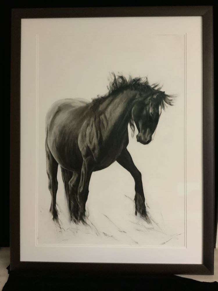
The Diva Takes a Bow
https://archives.whyte.org/en/permalink/artifactenm.03.02
- Date
- 2009
- Medium
- charcoal on primed paper
- Catalogue Number
- EnM.03.02
- Description
- A charcoal drawing of a black horse with head down is drawn in 3/4 view emerging from the left side of the paper. It’s hooves are left unfinished and dissolve into loose wisps. It’s mane is loose and flowing.
1 image
- Title
- The Diva Takes a Bow
- Date
- 2009
- Medium
- charcoal on primed paper
- Dimensions
- 101.6 x 76.2 cm
- Description
- A charcoal drawing of a black horse with head down is drawn in 3/4 view emerging from the left side of the paper. It’s hooves are left unfinished and dissolve into loose wisps. It’s mane is loose and flowing.
- Subject
- horse
- Credit
- Purchased from Maureen Enns, Cochrane, 2022
- Catalogue Number
- EnM.03.02
Images
This material is presented as originally created; it may contain outdated cultural descriptions and
potentially offensive content.
Read more.
Travel guides - British Columbia
https://archives.whyte.org/en/permalink/descriptions55926
- Part Of
- Ben Gadd fonds
- Scope & Content
- File consists of travel guides collected by Ben Gadd pertaining to various locations in British Columbia, including Rogers Pass, Berg Lake Trail, Victoria and Vancouver.
- Date Range
- [ca.2000]
- 2003
- Reference Code
- M590 / I / A / i / 11
- Description Level
- 5 / File
- GMD
- Published record
- Textual record
- Map
- Part Of
- Ben Gadd fonds
- Description Level
- 5 / File
- Fonds Number
- M590
- V810
- S61
- Series
- M590 / I : Personal records
- Sous-Fonds
- M590
- Sub-Series
- M590 / I / A : Travel guides and maps
- Accession Number
- 2021.20
- Reference Code
- M590 / I / A / i / 11
- Date Range
- [ca.2000]
- 2003
- Physical Description
- 2 cm of textual records
- Scope & Content
- File consists of travel guides collected by Ben Gadd pertaining to various locations in British Columbia, including Rogers Pass, Berg Lake Trail, Victoria and Vancouver.
- Subject Access
- Geography
- Travel
- Tourism
- Tourist information
- Geographic Access
- Canada
- British Columbia
- Victoria
- Vancouver
- Rogers Pass
- Berg Lake
- Reproduction Restrictions
- Copyright restrictions may apply
- Language
- English
- Category
- Exploration, discovery and travel
- Title Source
- Title based on contents of file
- Processing Status
- Processed
This material is presented as originally created; it may contain outdated cultural descriptions and
potentially offensive content.
Read more.
Travel guides - Canadian Rockies, Montana
https://archives.whyte.org/en/permalink/descriptions55927
- Part Of
- Ben Gadd fonds
- Scope & Content
- File consists of travel guides collected by Ben Gadd pertaining to the Canadian Rockies, as well as regions in Montana.
- Date Range
- [ca.2000]
- 2009
- Reference Code
- M590 / I / A / i / 13
- Description Level
- 5 / File
- GMD
- Published record
- Textual record
- Map
- Part Of
- Ben Gadd fonds
- Description Level
- 5 / File
- Fonds Number
- M590
- V810
- S61
- Series
- M590 / I : Personal records
- Sous-Fonds
- M590
- Sub-Series
- M590 / I / A : Travel guides and maps
- Accession Number
- 2021.20
- Reference Code
- M590 / I / A / i / 13
- Date Range
- [ca.2000]
- 2009
- Physical Description
- 1 cm of textual records
- Scope & Content
- File consists of travel guides collected by Ben Gadd pertaining to the Canadian Rockies, as well as regions in Montana.
- Notes
- Some items in file are annotated
- Subject Access
- Geography
- Travel
- Tourism
- Tourist information
- Geographic Access
- Canada
- Alberta
- British Columbia
- Canadian Rocky Mountains
- United States of America
- Montana
- Reproduction Restrictions
- Copyright restrictions may apply
- Language
- English
- Category
- Exploration, discovery and travel
- Title Source
- Title based on contents of file
- Processing Status
- Processed
This material is presented as originally created; it may contain outdated cultural descriptions and
potentially offensive content.
Read more.
Travel guides - United States, Italy
https://archives.whyte.org/en/permalink/descriptions55928
- Part Of
- Ben Gadd fonds
- Scope & Content
- File consists of travel guides collected by Ben Gadd pertaining to Olympic National Park and other destinations in the United States and Italy.
- Date Range
- [ca.1990-2010]
- Reference Code
- M590 / I / A / i / 14
- Description Level
- 5 / File
- GMD
- Published record
- Textual record
- Map
- Part Of
- Ben Gadd fonds
- Description Level
- 5 / File
- Fonds Number
- M590
- V810
- S61
- Series
- M590 / I : Personal records
- Sous-Fonds
- M590
- Sub-Series
- M590 / I / A : Travel guides and maps
- Accession Number
- 2021.20
- Reference Code
- M590 / I / A / i / 14
- Date Range
- [ca.1990-2010]
- Physical Description
- 2 cm of textual records
- Scope & Content
- File consists of travel guides collected by Ben Gadd pertaining to Olympic National Park and other destinations in the United States and Italy.
- Subject Access
- Geography
- Travel
- Tourism
- Tourist information
- National parks and reserves
- Geographic Access
- United States of America
- Washington
- Hawaii
- Italy
- Reproduction Restrictions
- Copyright restrictions may apply
- Language
- English
- Category
- Exploration, discovery and travel
- Title Source
- Title based on contents of file
- Processing Status
- Processed
This material is presented as originally created; it may contain outdated cultural descriptions and
potentially offensive content.
Read more.
Travel guides - Icefields
https://archives.whyte.org/en/permalink/descriptions55917
- Part Of
- Ben Gadd fonds
- Scope & Content
- File consists of travel guides collected by Ben Gadd pertaining to Columbia Icefield, Icefields Parkway and the Wapta Icefields.
- Date Range
- 1994
- [ca.2000]
- Reference Code
- M590 / I / A / i / 7
- Description Level
- 5 / File
- GMD
- Published record
- Textual record
- Map
- Part Of
- Ben Gadd fonds
- Description Level
- 5 / File
- Fonds Number
- M590
- V810
- S61
- Series
- M590 / I : Personal records
- Sous-Fonds
- M590
- Sub-Series
- M590 / I / A : Travel guides and maps
- Accession Number
- 2021.20
- Reference Code
- M590 / I / A / i / 7
- Date Range
- 1994
- [ca.2000]
- Physical Description
- 1 cm of textual records
- Scope & Content
- File consists of travel guides collected by Ben Gadd pertaining to Columbia Icefield, Icefields Parkway and the Wapta Icefields.
- Notes
- Travel guide of Wapta Icefields includes annotations on cover by Ben Gadd.
- Subject Access
- Geography
- Travel
- Tourism
- Tourist information
- Geographic Access
- Canada
- Alberta
- Jasper National Park
- Columbia Icefield
- Icefields Parkway
- British Columbia
- Wapta Icefields
- Reproduction Restrictions
- Copyright restrictions may apply
- Language
- English
- Category
- Exploration, discovery and travel
- Title Source
- Title based on contents of file
- Processing Status
- Processed
This material is presented as originally created; it may contain outdated cultural descriptions and
potentially offensive content.
Read more.
Travel guides - Waterton Lakes
https://archives.whyte.org/en/permalink/descriptions55918
- Part Of
- Ben Gadd fonds
- Scope & Content
- File consists of travel guides collected by Ben Gadd pertaining to Waterton Lakes National Park.
- Date Range
- [ca.1995-2000]
- Reference Code
- M590 / I / A / i / 8
- Description Level
- 5 / File
- GMD
- Published record
- Textual record
- Map
- Part Of
- Ben Gadd fonds
- Description Level
- 5 / File
- Fonds Number
- M590
- V810
- S61
- Series
- M590 / I : Personal records
- Sous-Fonds
- M590
- Sub-Series
- M590 / I / A : Travel guides and maps
- Accession Number
- 2021.20
- Reference Code
- M590 / I / A / i / 8
- Date Range
- [ca.1995-2000]
- Physical Description
- 1.5 cm of textual records
- Scope & Content
- File consists of travel guides collected by Ben Gadd pertaining to Waterton Lakes National Park.
- Notes
- One guide includes annotations on cover by Ben Gadd.
- Subject Access
- Geography
- Travel
- Tourism
- Tourist information
- Geographic Access
- Canada
- Alberta
- Waterton
- Waterton Lakes National Park
- Reproduction Restrictions
- Copyright restrictions may apply
- Language
- English
- Category
- Exploration, discovery and travel
- Title Source
- Title based on contents of file
- Processing Status
- Processed
This material is presented as originally created; it may contain outdated cultural descriptions and
potentially offensive content.
Read more.
Travel guides - Calgary, Bragg Creek, Edmonton
https://archives.whyte.org/en/permalink/descriptions55919
- Part Of
- Ben Gadd fonds
- Scope & Content
- File consists of travel guides collected by Ben Gadd pertaining to Calgary, Bragg Creek, Edmonton and surrounding areas.
- Date Range
- 1999
- 2003
- 2004
- Reference Code
- M590 / I / A / i / 9
- Description Level
- 5 / File
- GMD
- Published record
- Textual record
- Map
- Part Of
- Ben Gadd fonds
- Description Level
- 5 / File
- Fonds Number
- M590
- V810
- S61
- Series
- M590 / I : Personal records
- Sous-Fonds
- M590
- Sub-Series
- M590 / I / A : Travel guides and maps
- Accession Number
- 2021.20
- Reference Code
- M590 / I / A / i / 9
- Date Range
- 1999
- 2003
- 2004
- Physical Description
- 2 cm of textual records
- Scope & Content
- File consists of travel guides collected by Ben Gadd pertaining to Calgary, Bragg Creek, Edmonton and surrounding areas.
- Notes
- Some items in file are annotated
- Subject Access
- Geography
- Travel
- Tourism
- Tourist information
- Geographic Access
- Canada
- Alberta
- Calgary
- Bragg Creek
- Edmonton
- Reproduction Restrictions
- Copyright restrictions may apply
- Language
- English
- Category
- Exploration, discovery and travel
- Title Source
- Title based on contents of file
- Processing Status
- Processed
This material is presented as originally created; it may contain outdated cultural descriptions and
potentially offensive content.
Read more.
Travel guides - Alberta, British Columbia
https://archives.whyte.org/en/permalink/descriptions55920
- Part Of
- Ben Gadd fonds
- Scope & Content
- File consists of travel guides collected by Ben Gadd pertaining to various regions of Alberta and British Columbia.
- Date Range
- [ca.2000]
- 2008
- Reference Code
- M590 / I / A / i / 12
- Description Level
- 5 / File
- GMD
- Published record
- Textual record
- Map
- Part Of
- Ben Gadd fonds
- Description Level
- 5 / File
- Fonds Number
- M590
- V810
- S61
- Series
- M590 / I : Personal records
- Sous-Fonds
- M590
- Sub-Series
- M590 / I / A : Travel guides and maps
- Accession Number
- 2021.20
- Reference Code
- M590 / I / A / i / 12
- Date Range
- [ca.2000]
- 2008
- Physical Description
- 2 cm of textual records
- Scope & Content
- File consists of travel guides collected by Ben Gadd pertaining to various regions of Alberta and British Columbia.
- Notes
- Some items in file are annotated
- Subject Access
- Geography
- Travel
- Tourism
- Tourist information
- Geographic Access
- Canada
- Alberta
- British Columbia
- Reproduction Restrictions
- Copyright restrictions may apply
- Language
- English
- Category
- Exploration, discovery and travel
- Title Source
- Title based on contents of file
- Processing Status
- Processed
This material is presented as originally created; it may contain outdated cultural descriptions and
potentially offensive content.
Read more.