Narrow Results By
- Peter and Catharine Whyte fonds 49
- Luxton family fonds 12
- Pat Brewster fonds 4
- Vaux family fonds 3
- Alice Fulmer fonds 2
- Bert Riggall fonds 2
- Clifford Jackson White fonds 2
- David McDougall fonds 2
- Helen and George Shandruk fonds 2
- J. Norman Collie fonds 2
- Jim and Dorothy Boyce fonds 2
- Mary (Molly) Wright Adams fonds 2
- 1930s 12671
- 1920s 12216
- 1940s 11945
- 1910s 8186
- 1900s 6662
- 1950s 6340
- 1970s 6239
- 1960s 6021
- 1980s 3920
- 1990s 2534
- 2000s 1761
- 1890s 1619
- 2010s 1195
- 1880s 1007
- 1870s 753
- 2020s 237
- 1850s 235
- 1860s
- 1800s 104
- 1840s
- 1820s 66
- 1830s 66
- 1810s 39
- 1780s 34
- 1790s 17
- 1750s
- 1770s 10
- 1700s 6
- 1720s 3
- 1740s 3
- 1760s 3
- 1570s 2
- 1600s 2
- 1080s 1
- 1300s 1
- 1500s 1
- 1530s 1
- 1550s 1
- 1560s 1
- 1610s 1
- 1620s 1
- 1680s 1
- 1690s 1
- 1710s 1
- 1730s 1
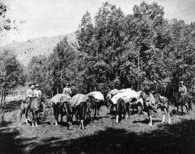
[Hunting party preparing to depart from Banff Indian Grounds or Brewster Corrals, Banff]
https://archives.whyte.org/en/permalink/descriptions49289
- Part Of
- Pat Brewster fonds
- Scope & Content
- Image of five people on horseback with five pack horses
- Date Range
- 1850-1910
- Reference Code
- v91 / 12 / a / na66 - 1716
- Description Level
- 6 / Item
- GMD
- Photograph
- Negative, copy
- Photograph, print
1 image
- Part Of
- Pat Brewster fonds
- Description Level
- 6 / Item
- Fonds Number
- M2 / V91 / S21
- Sous-Fonds
- V91
- Reference Code
- v91 / 12 / a / na66 - 1716
- Date Range
- 1850-1910
- Physical Description
- 1 photograph : negative : copy negative
- Scope & Content
- Image of five people on horseback with five pack horses
- Subject Access
- Discovery and Exploration
- Environment and Nature
- Sports and Recreation
- Transportation
- Geographic Access
- Alberta
- British Columbia
- Title Source
- Title based on contents of file
- Processing Status
- Processed
Images
This material is presented as originally created; it may contain outdated cultural descriptions and
potentially offensive content.
Read more.
- Part Of
- Moore family fonds
- Scope & Content
- Letters, certificates, scrapbook pages, ration book, notebook and publication pertaining to Julie Moore Raymond, James W. Brown and Brown family geneaology. Also includes a restaurant menu for 1812 House, Farmingham, Mass., the former Brown family residence.
- Date Range
- 1838-1950
- Reference Code
- M307 / V / 71
- Description Level
- 5 / File
- GMD
- Textual record
- Part Of
- Moore family fonds
- Description Level
- 5 / File
- Fonds Number
- M307 / V439
- Series
- V. Moore and Browne families series
- Sous-Fonds
- M307
- Accession Number
- .
- Reference Code
- M307 / V / 71
- GMD
- Textual record
- Date Range
- 1838-1950
- Physical Description
- 2 cm of textual records
- Scope & Content
- Letters, certificates, scrapbook pages, ration book, notebook and publication pertaining to Julie Moore Raymond, James W. Brown and Brown family geneaology. Also includes a restaurant menu for 1812 House, Farmingham, Mass., the former Brown family residence.
- Notes
- Bond issued by the Confederate States of America for 500 dollars, 1863, 1 item.
- Discharge document of James W. Brown, from the Commonwealth of Massachusetts, Boston, 1849, 1 item. Military commission certificate of James W. Brown, Commonwealth of Massachusetts, 1948 Held in oversize "B"
- Language
- English
- Title Source
- Title based on contents of file
- Processing Status
- Processed
This material is presented as originally created; it may contain outdated cultural descriptions and
potentially offensive content.
Read more.
[British North America]
https://archives.whyte.org/en/permalink/catalogue21421
- Medium
- Library - Maps and blueprints (unannotated; published)
- Map
- Published Date
- 1754-1761
- Publisher
- Canadian Geographic Journal (Public Archives of Canada)
- Call Number
- C11-1.2
- Publisher
- Canadian Geographic Journal (Public Archives of Canada)
- Published Date
- 1754-1761
- Subjects
- British North America
- Accession Number
- 495
- Call Number
- C11-1.2
- Collection
- Archives Library
This material is presented as originally created; it may contain outdated cultural descriptions and
potentially offensive content.
Read more.
[British North America]
https://archives.whyte.org/en/permalink/catalogue21422
- Medium
- Library - Maps and blueprints (unannotated; published)
- Map
- Published Date
- 1863
- Publisher
- John Arrowsmith. Republished by the Royal Canadian Geographical Society in 1967 in recognition of Canada's Centennial
- Call Number
- C11-1.3
- Publisher
- John Arrowsmith. Republished by the Royal Canadian Geographical Society in 1967 in recognition of Canada's Centennial
- Published Date
- 1863
- Subjects
- British North America
- Accession Number
- 495
- Call Number
- C11-1.3
- Collection
- Archives Library
This material is presented as originally created; it may contain outdated cultural descriptions and
potentially offensive content.
Read more.
Route of Lieut. Warre and Lieut. Vavasour from Red River to the Pacific Ocean
https://archives.whyte.org/en/permalink/catalogue21476
- Medium
- Library - Maps and blueprints (unannotated; published)
- Map
- Published Date
- 1845
- Call Number
- C12-1.3
- Published Date
- 1845
- Subjects
- Western Canada
- Notes
- Photostatic copy from Public Archives
- Accession Number
- 675
- Call Number
- C12-1.3
- Collection
- Archives Library
This material is presented as originally created; it may contain outdated cultural descriptions and
potentially offensive content.
Read more.
French map showing various districts
https://archives.whyte.org/en/permalink/catalogue21477
- Medium
- Library - Maps and blueprints (unannotated; published)
- Map
- Published Date
- 1869
- Call Number
- C12-1.4
- Published Date
- 1869
- Subjects
- Western Canada
- Notes
- Photostatic copy from Public Archives
- Accession Number
- 675
- Call Number
- C12-1.4
- Collection
- Archives Library
This material is presented as originally created; it may contain outdated cultural descriptions and
potentially offensive content.
Read more.
Outline of slave-holding States
https://archives.whyte.org/en/permalink/catalogue21512
- Medium
- Library - Maps and blueprints (unannotated; published)
- Map
- Published Date
- 1862
- Call Number
- C13-1.1
- Published Date
- 1862
- Subjects
- United States
- Accession Number
- 400
- Call Number
- C13-1.1
- Collection
- Archives Library
This material is presented as originally created; it may contain outdated cultural descriptions and
potentially offensive content.
Read more.
- Medium
- Library - Maps and blueprints (unannotated; published)
- Map
- Published Date
- 1864
- Publisher
- Bacon and Co.
- Call Number
- C13-1.10
- Publisher
- Bacon and Co.
- Published Date
- 1864
- Subjects
- Virginia/Maryland, United States
- Notes
- "Bacon's New Shilling War Map"
- Accession Number
- 400
- Call Number
- C13-1.10
- Collection
- Archives Library
This material is presented as originally created; it may contain outdated cultural descriptions and
potentially offensive content.
Read more.
- Medium
- Library - Book (including soft-cover and pamphlets)
- Published Date
- 1861
- Publisher
- London : British and Foreign Bible Society
- Call Number
- 07.2 B47
- Publisher
- London : British and Foreign Bible Society
- Published Date
- 1861
- Physical Description
- 855, 292p
- Notes
- Inscribed: This Bible was presented to Rev. Robert Terrill Rundle by the British & Foreign Bible Society, being the first copy printed in the Cree language
- Accession Number
- 2873
- Call Number
- 07.2 B47
- Collection
- Archives Library
This material is presented as originally created; it may contain outdated cultural descriptions and
potentially offensive content.
Read more.
A general map of the routes in British North America explored by the expedition under Captain Palliser, 1857-1860
https://archives.whyte.org/en/permalink/catalogue24301
- Medium
- Library - Maps and blueprints (unannotated; published)
- Map
- Published Date
- 1865
- Publisher
- Stanford's, London, England
- Call Number
- C6-3.4
- Publisher
- Stanford's, London, England
- Published Date
- 1865
- Scale
- 1' - 28 miles
- Subjects
- Palliser Route
- Notes
- Bench marks
- Accession Number
- 956
- Call Number
- C6-3.4
- Collection
- Archives Library
This material is presented as originally created; it may contain outdated cultural descriptions and
potentially offensive content.
Read more.


