Narrow Results By
- Murray Hay fonds 18
- Nicholas Morant fonds 7
- Ben Gadd fonds 6
- Luxton family fonds 3
- George K. K. (Tommy) Link fonds 2
- Trail Riders of the Canadian Rockies fonds 2
- Arnold Wexler fonds 1
- Arthur Oliver Wheeler fonds 1
- Bert Riggall fonds 1
- Bob Hind fonds 1
- Bob Smith fonds 1
- Brewster Transport Company Ltd. fonds 1
- Peter Whyte (1905 – 1966, Canadian) 345
- Charles John Collings (1848 – 1931, British) 203
- Catharine Robb Whyte, O. C. (1906 – 1979, Canadian) 35
- Hay, Murray 18
- Gadd, Ben 6
- Henry George Glyde (1906 – 1998, Canadian) 2
- Morant, Nicholas 2
- Nicholas Morant 2
- Schaffer, Mary 2
- Adams, Molly 1
- Alberta/British Columbia Boundary Survey 1
- Alexander Young Jackson (1882 – 1974, Canadian) 1
- Date
- 1972
- Medium
- graphite on paper
- Catalogue Number
- GyH.03.31
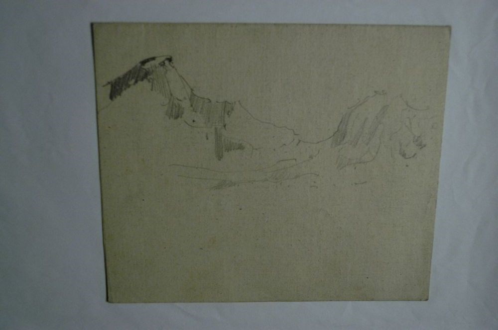
- Description
- A mountain landscape sketch. Two peaks rise on the left, a rounded peak with tree coverage sits in the bottom right. Bottom left “5 Mile Banff July ‘72”, bottom right “Glyde.”
1 image
- Title
- 5 Mile Banff
- Date
- 1972
- Medium
- graphite on paper
- Description
- A mountain landscape sketch. Two peaks rise on the left, a rounded peak with tree coverage sits in the bottom right. Bottom left “5 Mile Banff July ‘72”, bottom right “Glyde.”
- Credit
- Gift of Henry George Glyde, Victoria, 1997
- Catalogue Number
- GyH.03.31
Images

This material is presented as originally created; it may contain outdated cultural descriptions and
potentially offensive content.
Read more.
12:30 Bow River
https://archives.whyte.org/en/permalink/artifactcoj.03.431
- Date
- c. 1920
- Medium
- graphite on paper
- Catalogue Number
- CoJ.03.431
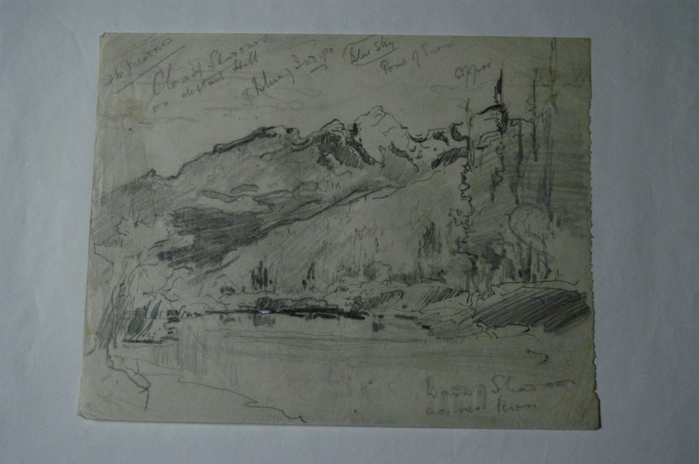
- Description
- Pencil sketch on CPR card paper of mountains.Extensive description on inside and back of card denoting colour scheme, time of day and other details.
1 image
- Title
- 12:30 Bow River
- Date
- c. 1920
- Medium
- graphite on paper
- Dimensions
- 14.5 x 17.5 cm
- Description
- Pencil sketch on CPR card paper of mountains.Extensive description on inside and back of card denoting colour scheme, time of day and other details.
- Subject
- landscape
- Credit
- Gift of John Rivette, Seymour Arm, 1997
- Catalogue Number
- CoJ.03.431
Images
This material is presented as originally created; it may contain outdated cultural descriptions and
potentially offensive content.
Read more.
1978 map of Mount Assiniboine Provincial Park
https://archives.whyte.org/en/permalink/catalogue21315
- Medium
- Library - Maps and blueprints (unannotated; published)
- Map
- Published Date
- 1978 (transfered to manuscrpits Oct. 1994)
- Publisher
- Ministry of Recreation and Conservation
- Call Number
- C2-10.1 (e)
- Publisher
- Ministry of Recreation and Conservation
- Published Date
- 1978 (transfered to manuscrpits Oct. 1994)
- Subjects
- Mount Assiniboine Provincial Park
- Notes
- Descriptive Legend on back of map re: History Winter Activity, Access, Avalanche Safety, Equipment, Trail and Camping Information etc.
- Accession Number
- 11000
- Call Number
- C2-10.1 (e)
- Collection
- Archives Library
This material is presented as originally created; it may contain outdated cultural descriptions and
potentially offensive content.
Read more.
Abruzzi, Mount
https://archives.whyte.org/en/permalink/catalogue23436
- Medium
- Library - Maps and blueprints (unannotated; published)
- Map
- Published Date
- Updated from aerial photographs, taken in 1972. Culture check, 1975. Info current as of 1975.
- Publisher
- Surveys and Mapping Branch, Dept. of Energy, Mines and Resources
- Edition
- Edition 2
- Call Number
- NTS
- 82J/6
- Edition
- Edition 2
- Publisher
- Surveys and Mapping Branch, Dept. of Energy, Mines and Resources
- Published Date
- Updated from aerial photographs, taken in 1972. Culture check, 1975. Info current as of 1975.
- Scale
- Scale: 1:50,000
- Subjects
- Mount Abruzzi
- Notes
- National Topographic System
- Complete reference/reverse side of map
- Accession Number
- 9500
- Call Number
- NTS
- 82J/6
- Collection
- Archives Library
This material is presented as originally created; it may contain outdated cultural descriptions and
potentially offensive content.
Read more.
Across the River
https://archives.whyte.org/en/permalink/artifactcoj.03.419
- Date
- c. 1920
- Medium
- graphite on paper
- Catalogue Number
- CoJ.03.419
- Description
- Pencil drawing of landscape with water in foreground and mountains in background.brc: Band of shadows across riverOther cursive writing denotes details and colour scheme.
1 image
- Title
- Across the River
- Date
- c. 1920
- Medium
- graphite on paper
- Dimensions
- 20.0 x 26.0 cm
- Description
- Pencil drawing of landscape with water in foreground and mountains in background.brc: Band of shadows across riverOther cursive writing denotes details and colour scheme.
- Subject
- landscape
- Credit
- Gift of John Rivette, Seymour Arm, 1997
- Catalogue Number
- CoJ.03.419
Images
This material is presented as originally created; it may contain outdated cultural descriptions and
potentially offensive content.
Read more.
Aerochrome Infrared photograph of Banff and surrounding area
https://archives.whyte.org/en/permalink/catalogue24805
- Medium
- Library - Maps and blueprints (unannotated; published)
- Map
- Published Date
- August 1972
- Call Number
- C12-4.22
- Published Date
- August 1972
- Scale
- 1:17,000
- Subjects
- Banff - Aerial Photo
- Notes
- Legend: 12 designated townsite areas
- See: Fig. 1, 2, 3 on reverse side of map
- Call Number
- C12-4.22
- Collection
- Archives Library
This material is presented as originally created; it may contain outdated cultural descriptions and
potentially offensive content.
Read more.
Agassiz, Yale District
https://archives.whyte.org/en/permalink/artifactcoj.03.422
- Date
- c. 1920
- Medium
- graphite on paper
- Catalogue Number
- CoJ.03.422
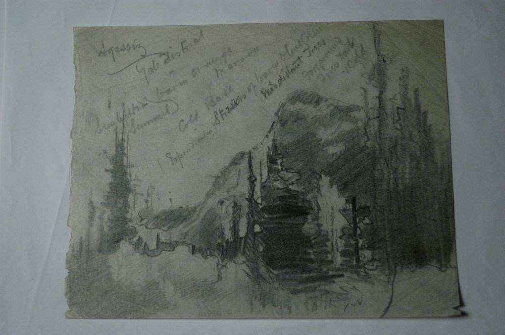
- Description
- A drawing of a mountain stream by trees in foreground. Heavy shading/pencil use.Cursive writing denotes details and colour scheme.
1 image
- Title
- Agassiz, Yale District
- Date
- c. 1920
- Medium
- graphite on paper
- Dimensions
- 20.0 x 26.0 cm
- Description
- A drawing of a mountain stream by trees in foreground. Heavy shading/pencil use.Cursive writing denotes details and colour scheme.
- Subject
- landscape
- Credit
- Gift of John Rivette, Seymour Arm, 1997
- Catalogue Number
- CoJ.03.422
Images
This material is presented as originally created; it may contain outdated cultural descriptions and
potentially offensive content.
Read more.
[Aishihik Lake 115H, Yukon]
https://archives.whyte.org/en/permalink/catalogue24002
- Medium
- Library - Maps and blueprints (unannotated; published)
- Map
- Published Date
- 1971
- Publisher
- Dept. of Energy, Mines and Resources
- Call Number
- NTS
- 115H
- Publisher
- Dept. of Energy, Mines and Resources
- Published Date
- 1971
- Physical Description
- 1 map : col
- Scale
- Scale: 1:250,000
- Relief: Contour interval 500 ft.
- Subjects
- Aishihik Lake
- Yukon Territory
- Notes
- National Topographic System
- Accession Number
- 3000
- Call Number
- NTS
- 115H
- Collection
- Archives Library
This material is presented as originally created; it may contain outdated cultural descriptions and
potentially offensive content.
Read more.
Alberta : Athabaska sheet
https://archives.whyte.org/en/permalink/catalogue24415
- Medium
- Library - Maps and blueprints (unannotated; published)
- Map
- Published Date
- 1914
- Publisher
- Ottawa: Office of the Surveyor General
- Edition
- 2d ed.
- Call Number
- C9-2.4
- Edition
- 2d ed.
- Publisher
- Ottawa: Office of the Surveyor General
- Published Date
- 1914
- Physical Description
- 1 map
- Scale
- Scale: 1:190,080
- Subjects
- Athabaska River
- Notes
- Sectional map
- Accession Number
- 5576
- 4008
- Call Number
- C9-2.4
- Collection
- Archives Library
This material is presented as originally created; it may contain outdated cultural descriptions and
potentially offensive content.
Read more.
[Alberta] 2 sections
https://archives.whyte.org/en/permalink/catalogue24384
- Medium
- Library - Maps and blueprints (unannotated; published)
- Map
- Published Date
- 1974
- Publisher
- Surveys Branch, Department of Highways and Transport
- Call Number
- C9-1.3(c)
- Publisher
- Surveys Branch, Department of Highways and Transport
- Published Date
- 1974
- Physical Description
- 1 map : col
- Scale
- Scale: 12 miles: 1 inch
- Subjects
- Alberta
- Accession Number
- SG7500
- Call Number
- C9-1.3(c)
- Collection
- Archives Library
This material is presented as originally created; it may contain outdated cultural descriptions and
potentially offensive content.
Read more.