Narrow Results By
Canadian Irrigation Surveys; A preliminary map of a portion of the foothills region from photographic and micrometer surveys by Division B; A.O. Wheeler in charge.
https://archives.whyte.org/en/permalink/catalogue23360
- Medium
- Library - Maps and blueprints (unannotated; published)
- Map
- Published Date
- 1895-6
- Publisher
- Department of the Interior
- Call Number
- C5-6.26(c)
- Publisher
- Department of the Interior
- Published Date
- 1895-6
- Physical Description
- Black and white
- Scale
- 1 1/4 miles - 1"
- Subjects
- Alberta-Irrigation
- Notes
- xerox copy
- Accession Number
- 6000
- Call Number
- C5-6.26(c)
- Collection
- Archives Library
This material is presented as originally created; it may contain outdated cultural descriptions and
potentially offensive content.
Read more.
Cart trail from Calgary to Edmonton
https://archives.whyte.org/en/permalink/catalogue24486
- Medium
- Library - Maps and blueprints (unannotated; published)
- Map
- Published Date
- 1890
- Publisher
- Dept. of the Interior
- Call Number
- C9-7.31
- Publisher
- Dept. of the Interior
- Published Date
- 1890
- Scale
- 1 mile: 2 inches
- Notes
- photostatic copy from Public Archives
- Accession Number
- 675
- Call Number
- C9-7.31
- Collection
- Archives Library
This material is presented as originally created; it may contain outdated cultural descriptions and
potentially offensive content.
Read more.
(Castle Mtn. area)
https://archives.whyte.org/en/permalink/catalogue24472
- Medium
- Library - Maps and blueprints (unannotated; published)
- Map
- Published Date
- April 26th, 1890
- Publisher
- Dominion Lands Office
- Call Number
- C9-7.25
- Publisher
- Dominion Lands Office
- Published Date
- April 26th, 1890
- Physical Description
- 1 map : col
- Scale
- 40 chains: 1 "
- Accession Number
- SG7500
- Call Number
- C9-7.25
- Collection
- Archives Library
This material is presented as originally created; it may contain outdated cultural descriptions and
potentially offensive content.
Read more.
Dominion of Canada and Newfoundland
https://archives.whyte.org/en/permalink/catalogue24550
- Medium
- Library - Maps and blueprints (unannotated; published)
- Map
- Published Date
- 1898
- Publisher
- Rand McNally and Co. Republished by the Royal Canadian Geographical Society in 1967 in recognition of Canada's Centennial
- Call Number
- C11-2.3
- Publisher
- Rand McNally and Co. Republished by the Royal Canadian Geographical Society in 1967 in recognition of Canada's Centennial
- Published Date
- 1898
- Scale
- Scale: 180 miles - 1 inch
- Subjects
- Canada
- Notes
- Duplicate in map room/Accn: 400)
- Accession Number
- 400
- 673
- Call Number
- C11-2.3
- Collection
- Archives Library
This material is presented as originally created; it may contain outdated cultural descriptions and
potentially offensive content.
Read more.
(edge of Lake Louise Forest Park)
https://archives.whyte.org/en/permalink/catalogue24485
- Medium
- Library - Maps and blueprints (unannotated; published)
- Map
- Published Date
- January 7th, 1896
- Publisher
- Department of the Interior
- Call Number
- C9-7.29
- Publisher
- Department of the Interior
- Published Date
- January 7th, 1896
- Physical Description
- 1 map : black and white
- Scale
- 40 chains: 1 inch
- Notes
- xerox copy
- Accession Number
- SG7500
- Call Number
- C9-7.29
- Collection
- Archives Library
This material is presented as originally created; it may contain outdated cultural descriptions and
potentially offensive content.
Read more.
- Medium
- Library - Maps and blueprints (unannotated; published)
- Map
- Published Date
- 1898
- Call Number
- C12-1.13
- Published Date
- 1898
- Scale
- 50 miles to 1 inch
- Subjects
- Northwestern Canada
- Notes
- four sections
- Photostatic copy from Public Archives
- Accession Number
- 675
- Call Number
- C12-1.13
- Collection
- Archives Library
This material is presented as originally created; it may contain outdated cultural descriptions and
potentially offensive content.
Read more.
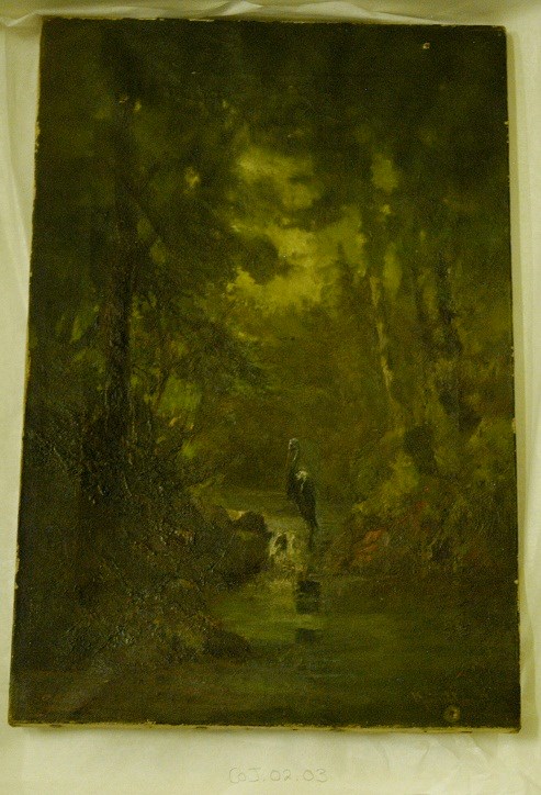
- Date
- 1893
- Medium
- oil on canvas
- Catalogue Number
- CoJ.02.03
- Description
- Scene in a forest with a stream. Overall green value of the painting, - there is a herring standing in the steam just below center at the narrowest part where the stream seems to drop to a lower level. - dark green shadows across the top of the trees where they appear to canopy the scene. - dark br…
1 image
- Title
- His Haunt
- Date
- 1893
- Medium
- oil on canvas
- Dimensions
- 45.5 x 30.5 cm
- Description
- Scene in a forest with a stream. Overall green value of the painting, - there is a herring standing in the steam just below center at the narrowest part where the stream seems to drop to a lower level. - dark green shadows across the top of the trees where they appear to canopy the scene. - dark brown bank to the left of the steam, and a dark green/yellow to the right of the stream.
- Subject
- landscape
- Canadian Rockies
- heron
- stream
- Credit
- Gift of John Rivette, Seymour Arm, 1982
- Catalogue Number
- CoJ.02.03
Images
This material is presented as originally created; it may contain outdated cultural descriptions and
potentially offensive content.
Read more.
(Lake Louise Forest Park)
https://archives.whyte.org/en/permalink/catalogue24484
- Medium
- Library - Maps and blueprints (unannotated; published)
- Map
- Published Date
- February 10, 1896
- Publisher
- Department of the Interior
- Call Number
- C9-7.28
- Publisher
- Department of the Interior
- Published Date
- February 10, 1896
- Physical Description
- 1 map : black and white
- Scale
- 40 chains: 1 inch
- Notes
- xerox copy
- Accession Number
- SG7500
- Call Number
- C9-7.28
- Collection
- Archives Library
This material is presented as originally created; it may contain outdated cultural descriptions and
potentially offensive content.
Read more.
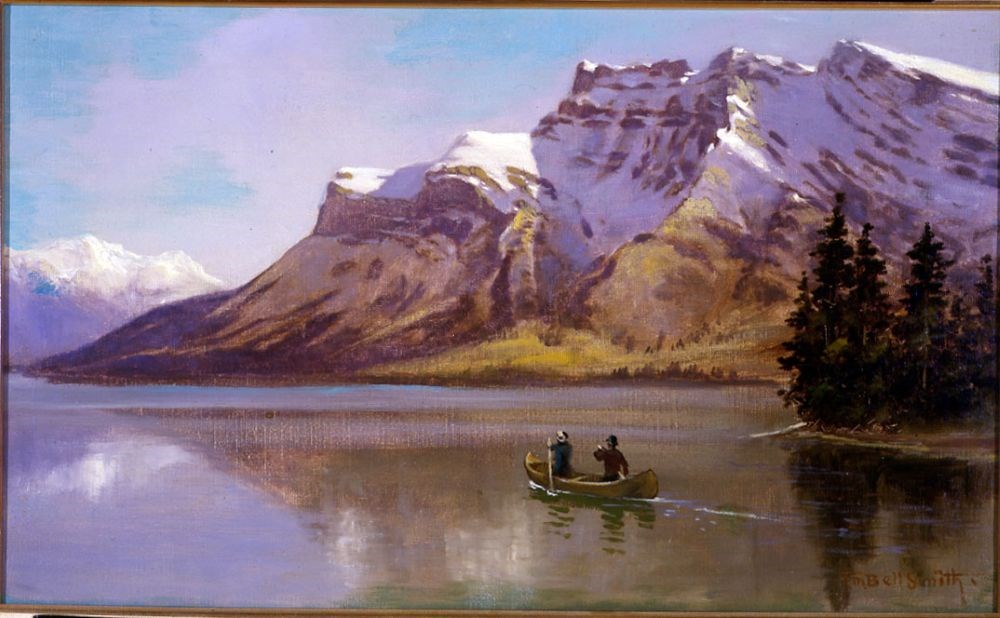
Lake Minnewanka and Mount Inglismaldie
https://archives.whyte.org/en/permalink/artifactbes.02.01
- Date
- 1890
- Medium
- oil on canvas
- Catalogue Number
- BeS.02.01
- Description
- Colour: blue, green. The lower half is a lake with two people in a canoe right of center. A piece of land with evergreens comes out at the right side. The upper half is a mountain range. At the left side in the distance is another range. Above is clear blue sky.This painting was lent to the Winnipe…
1 image
- Title
- Lake Minnewanka and Mount Inglismaldie
- Date
- 1890
- Medium
- oil on canvas
- Dimensions
- 34.0 x 57.0 cm
- Description
- Colour: blue, green. The lower half is a lake with two people in a canoe right of center. A piece of land with evergreens comes out at the right side. The upper half is a mountain range. At the left side in the distance is another range. Above is clear blue sky.This painting was lent to the Winnipeg Art Gallery in 1975 to be included in the exhibition The Railway: A Patron of the Arts in Canada. The exhibition was circulated accross the country for two years.
- Credit
- Purchased from Red River Books, 1968
- Catalogue Number
- BeS.02.01
Images
This material is presented as originally created; it may contain outdated cultural descriptions and
potentially offensive content.
Read more.
Map of the Kootenay District - A mining recording divisions map
https://archives.whyte.org/en/permalink/catalogue24533
- Medium
- Library - Maps and blueprints (unannotated; published)
- Map
- Published Date
- 1897
- Publisher
- Dept. of Lands and Works, Victoria
- Call Number
- C10-6.3
- Publisher
- Dept. of Lands and Works, Victoria
- Published Date
- 1897
- Scale
- Scale: 12 miles - 1 inch
- Subjects
- Central British Columbia
- Notes
- Photostatic copy from Public Archives
- Accession Number
- 675
- Call Number
- C10-6.3
- Collection
- Archives Library
This material is presented as originally created; it may contain outdated cultural descriptions and
potentially offensive content.
Read more.