Narrow Results By
- Catharine Robb Whyte, O. C. (1906 – 1979, Canadian) 57
- Les Graff (1936 – , Canadian) 46
- Sitting Wind (1925 – 2002, Canadian) 6
- Michael Cameron (1955 – , Canadian) 4
- Robert Francis Michael McInnis (1942 – , Canadian) 4
- Earl F. Spencer 3
- Henry George Glyde (1906 – 1998, Canadian) 2
- Herbert C. Hahn (1907 – , American) 2
- Alfred Crocker Leighton, R. C. A. (1901 – 1965, Canadian) 1
- Charles Fraser Comfort (1900 – 1994, Canadian) 1
- David More (1947 – , Canadian) 1
- Donald Curran (1955 – ) 1
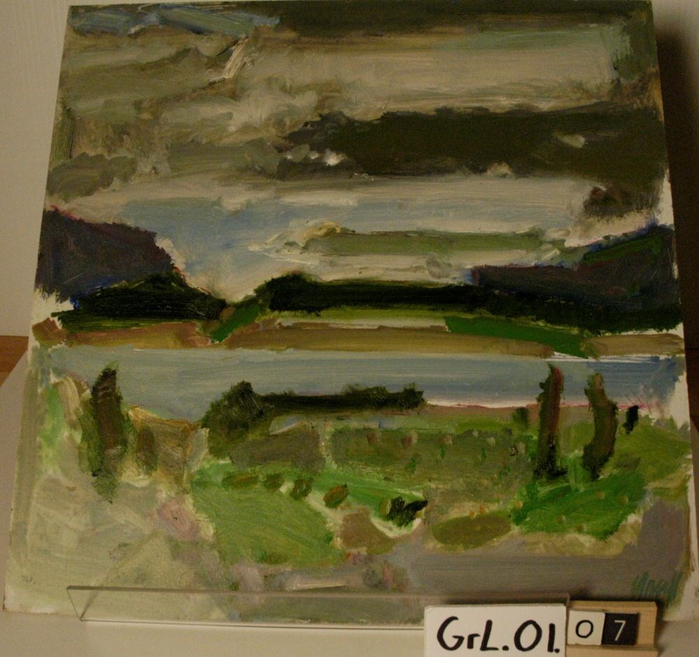
Abraham Lake #3
https://archives.whyte.org/en/permalink/artifactgrl.01.07
- Date
- 2000 – 2000
- Medium
- oil on masonite board
- Catalogue Number
- Grl.01.07
- Description
- An oil sketch of a lake landscape. The primary colours used are green, grey, blue and brown. The sky is dominated with thick grey strokes of colour. Surrounding the water at the top and bottom are thick strokes of green. The blue of the water is a streak across the middle of the work. The artist’s …
1 image
- Title
- Abraham Lake #3
- Date
- 2000 – 2000
- Medium
- oil on masonite board
- Dimensions
- 40.5 x 40.5 cm
- Description
- An oil sketch of a lake landscape. The primary colours used are green, grey, blue and brown. The sky is dominated with thick grey strokes of colour. Surrounding the water at the top and bottom are thick strokes of green. The blue of the water is a streak across the middle of the work. The artist’s signature is in the brhc in green paint.
- Credit
- Gift of Les Graff, Bashaw, 2006
- Catalogue Number
- Grl.01.07
Images
This material is presented as originally created; it may contain outdated cultural descriptions and
potentially offensive content.
Read more.
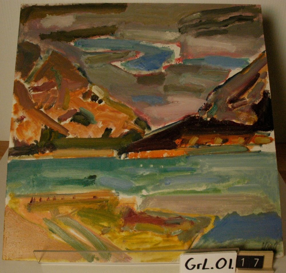
Abraham Lake/East
https://archives.whyte.org/en/permalink/artifactgrl.01.17
- Date
- 2001 – 2001
- Medium
- oil on masonite board
- Catalogue Number
- GrL.01.17
- Description
- An oil sketch of a mountain landscape. The primary colours used are blue, orange, red and brown. The image is composed of a mountain range in the background, with a body of water and a segment of land in the foreground. The artist’s signature is in the brhc in grey paint. Au verso, written in black…
1 image
- Title
- Abraham Lake/East
- Date
- 2001 – 2001
- Medium
- oil on masonite board
- Dimensions
- 40 x 40.5 cm
- Description
- An oil sketch of a mountain landscape. The primary colours used are blue, orange, red and brown. The image is composed of a mountain range in the background, with a body of water and a segment of land in the foreground. The artist’s signature is in the brhc in grey paint. Au verso, written in black ink in the trhc, “45/W”.
- Credit
- Gift of Les Graff, Bashaw, 2006
- Catalogue Number
- GrL.01.17
Images
This material is presented as originally created; it may contain outdated cultural descriptions and
potentially offensive content.
Read more.
[Abruzzi, Mount 82J/6 East, B.C.]
https://archives.whyte.org/en/permalink/catalogue23438
- Medium
- Library - Maps and blueprints (unannotated; published)
- Map
- Published Date
- 1966
- Publisher
- Dept. of Mines and Technical Surveys
- Call Number
- NTS
- 82J/6E
- Publisher
- Dept. of Mines and Technical Surveys
- Published Date
- 1966
- Physical Description
- 1 map : col
- Scale
- Scale: 1:50,000
- Relief: Contour interval 100'
- Subjects
- Mount Abruzzi
- British Columbia
- Notes
- National Topographic System
- Accession Number
- 718
- Call Number
- NTS
- 82J/6E
- Collection
- Archives Library
This material is presented as originally created; it may contain outdated cultural descriptions and
potentially offensive content.
Read more.
[Abruzzi, Mount 82J/6 West, B.C.]
https://archives.whyte.org/en/permalink/catalogue23437
- Medium
- Library - Maps and blueprints (unannotated; published)
- Map
- Published Date
- 1966
- Publisher
- Dept. of Mines and Technical Surveys
- Call Number
- NTS
- 82J/6W
- Publisher
- Dept. of Mines and Technical Surveys
- Published Date
- 1966
- Physical Description
- 1 map : col
- Scale
- Scale: 1:50,000
- Relief: Contour interval 100'
- Subjects
- Mount Abruzzi
- British Columbia
- Notes
- National Topographic System
- Accession Number
- 718
- Call Number
- NTS
- 82J/6W
- Collection
- Archives Library
This material is presented as originally created; it may contain outdated cultural descriptions and
potentially offensive content.
Read more.
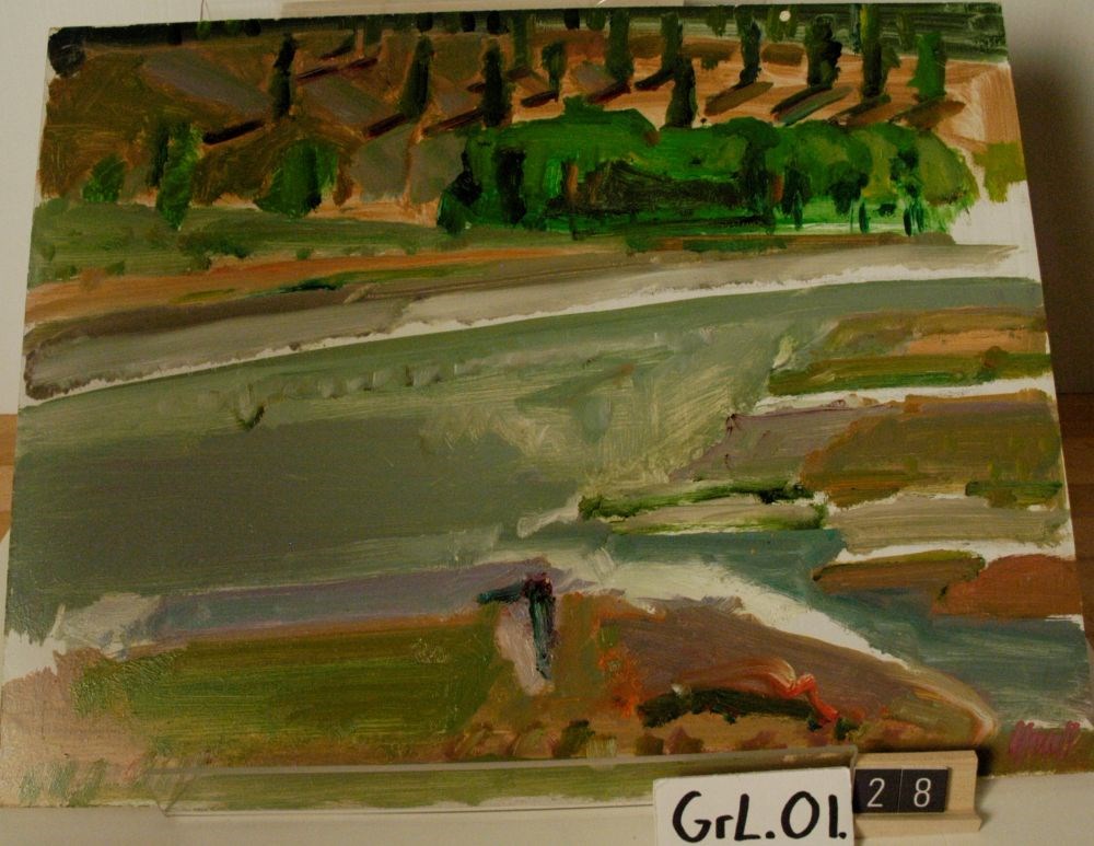
Across the North Saskatchewan River/Shadows
https://archives.whyte.org/en/permalink/artifactgrl.01.28
- Date
- 2003 – 2003
- Medium
- oil on masonite board
- Catalogue Number
- GrL.01.28
- Description
- An oil sketch of a landscape. The primary colours used are green, grey, purple and beige. The upper third of the piece is in green, red and beige, with the shadows of the trees depicted as red lines. The majority of the canvas centre is grey, with a variety of colours on the right centre. The artis…
1 image
- Title
- Across the North Saskatchewan River/Shadows
- Date
- 2003 – 2003
- Medium
- oil on masonite board
- Dimensions
- 35.6 x 40.7 cm
- Description
- An oil sketch of a landscape. The primary colours used are green, grey, purple and beige. The upper third of the piece is in green, red and beige, with the shadows of the trees depicted as red lines. The majority of the canvas centre is grey, with a variety of colours on the right centre. The artist’s signature is in the blhc in purple paint. Au verso, written in black ink in the tlhc, “47/R”.
- Credit
- Gift of Les Graff, Bashaw, 2007
- Catalogue Number
- GrL.01.28
Images
This material is presented as originally created; it may contain outdated cultural descriptions and
potentially offensive content.
Read more.
[Adams Lookout, Alberta]
https://archives.whyte.org/en/permalink/catalogue23439
- Medium
- Library - Maps and blueprints (unannotated; published)
- Map
- Published Date
- 1962
- Publisher
- Dept. of Mines & Technical Surveys
- Call Number
- NTS
- 83E/10E
- Publisher
- Dept. of Mines & Technical Surveys
- Published Date
- 1962
- Scale
- Scale: 1:50,000
- Subjects
- Adams Lookout
- Alberta
- Notes
- National Topographic System
- Accession Number
- 12000
- Call Number
- NTS
- 83E/10E
- Collection
- Archives Library
This material is presented as originally created; it may contain outdated cultural descriptions and
potentially offensive content.
Read more.
[Adams Lookout, Alberta]
https://archives.whyte.org/en/permalink/catalogue23440
- Medium
- Library - Maps and blueprints (unannotated; published)
- Map
- Published Date
- 1962
- Publisher
- Dept. of Mines and Technical Surveys
- Call Number
- NTS
- 83W/10W
- Publisher
- Dept. of Mines and Technical Surveys
- Published Date
- 1962
- Scale
- Scale: 1:50,000
- Subjects
- Adams Lookout
- Alberta
- Notes
- National Topographic System
- Accession Number
- 12000
- Call Number
- NTS
- 83W/10W
- Collection
- Archives Library
This material is presented as originally created; it may contain outdated cultural descriptions and
potentially offensive content.
Read more.
[Adams Plateau 82M/4 East, B.C.]
https://archives.whyte.org/en/permalink/catalogue23441
- Medium
- Library - Maps and blueprints (unannotated; published)
- Map
- Published Date
- 1961
- Publisher
- Department of Mines and Technical Surveys
- Call Number
- NTS
- 82M/4E
- Publisher
- Department of Mines and Technical Surveys
- Published Date
- 1961
- Physical Description
- 1 map : col
- Scale
- Scale: 1:50,000
- Relief: Contour interval 100 ft.
- Subjects
- Adams Plateau
- British Columbia
- Notes
- National Topographic System
- Accession Number
- 7000
- Call Number
- NTS
- 82M/4E
- Collection
- Archives Library
This material is presented as originally created; it may contain outdated cultural descriptions and
potentially offensive content.
Read more.
[Adams Plateau 82M/4 West, B.C.]
https://archives.whyte.org/en/permalink/catalogue23442
- Medium
- Library - Maps and blueprints (unannotated; published)
- Map
- Published Date
- 1961
- Publisher
- Department of Mines and Technical Surveys
- Call Number
- NTS
- 82M/4W
- Publisher
- Department of Mines and Technical Surveys
- Published Date
- 1961
- Physical Description
- 1 map : col
- Scale
- Scale: 1:50,000
- Relief: Contour interval 100 ft.
- Subjects
- Adams Plateau
- British Columbia
- Notes
- National Topographic System
- Accession Number
- 7000
- Call Number
- NTS
- 82M/4W
- Collection
- Archives Library
This material is presented as originally created; it may contain outdated cultural descriptions and
potentially offensive content.
Read more.
[Adams River 82M/11 East, B.C.]
https://archives.whyte.org/en/permalink/catalogue23443
- Medium
- Library - Maps and blueprints (unannotated; published)
- Map
- Published Date
- 1961
- Publisher
- Dept. of Mines and Technical Surveys
- Call Number
- NTS
- 82M/11E
- Publisher
- Dept. of Mines and Technical Surveys
- Published Date
- 1961
- Physical Description
- 1 map : col
- Scale
- Scale: 1:50,000
- Relief: Contour interval 100 ft.
- Subjects
- Adams River
- British Columbia
- Notes
- National Topographic System
- Accession Number
- 3000
- Call Number
- NTS
- 82M/11E
- Collection
- Archives Library
This material is presented as originally created; it may contain outdated cultural descriptions and
potentially offensive content.
Read more.