Narrow Results By
[100 YR SWISS CENTENNIAL CLIMB 1999: Faye Summit notes. Bow Hut OCT - DEC 1998]
https://archives.whyte.org/en/permalink/descriptions57743
- Part Of
- Alpine Club of Canada fonds
- Scope & Content
- File consists of summit notes from Mount Fay produced by the Alpine Club of Canada between 1998 and 1999. Summit record includes entries from visitors to the various summits which pertain to individuals' hiking and climbing trips; details of specific events which occurred while at the summit, wildl…
- Date Range
- 1998-1999
- Reference Code
- M200 / V / A / 156
- Description Level
- 5 / File
- GMD
- Textual record
- Organization record
- Part Of
- Alpine Club of Canada fonds
- Description Level
- 5 / File
- Fonds Number
- M200
- V14
- S6
- Series
- M200 / V: Summit Records
- Sous-Fonds
- M200
- Sub-Series
- M200 / V / A: Identified Summit Records
- Accession Number
- accn. 2023.06
- Reference Code
- M200 / V / A / 156
- Responsibility
- Summit Registers and Notes produced by Alpine Club of Canada
- Date Range
- 1998-1999
- Physical Description
- 0.5 cm of textual records
- History / Biographical
- Mount Fay is located along the Continental/Great Divide, along the Alberta and British Columbia border. Mount Fay is part of the Canadian Rockies.
- Scope & Content
- File consists of summit notes from Mount Fay produced by the Alpine Club of Canada between 1998 and 1999. Summit record includes entries from visitors to the various summits which pertain to individuals' hiking and climbing trips; details of specific events which occurred while at the summit, wildlife sightings, trail updates, and related topics. File: M200 / V / A / 156: [100 YR SWISS CENTENNIAL CLIMB 1999: Faye Summit notes. Bow Hut OCT - DEC 1998]
- Notes
- For Bow Hut Register, see M200 / IV / F / 31
- Name Access
- Alpine Club of Canada
- Subject Access
- Alberta
- Alpine Club of Canada
- Backpacking
- British Columbia
- Climbing
- Club
- Description and travel
- Environment
- Environment and Nature
- Great Divide
- Hiking
- Mountain
- Mountaineering
- Mountaineers
- Mountains
- Record keeping
- Ski mountaineering
- Sports and leisure
- Sports and recreation
- Summit
- Trails
- Geographic Access
- Canada
- Canadian Rocky Mountains
- Great Divide
- Continental Divide
- Alberta
- British Columbia
- Mount Fay
- Access Restrictions
- Restrictions may apply
- Language
- English
- Related Material
- M235
- M200 / IV / F / 31
- Title Source
- Title based on contents of file
- Processing Status
- Processed
This material is presented as originally created; it may contain outdated cultural descriptions and
potentially offensive content.
Read more.
1964 ski trip, skiing with friends
https://archives.whyte.org/en/permalink/descriptions55310
- Part Of
- Chic Scott fonds
- Scope & Content
- File consists of photographs pertaining to Hans Gmoser skiing with friends. Most photographs are from a 1964 ski trip between Toby Creek and the Bugaboos mountain range in British Columbia.
- Date Range
- 1964
- [1980 - 1990]
- Reference Code
- V40 / V / PA - 1 to 24
- Description Level
- 5 / File
- Part Of
- Chic Scott fonds
- Description Level
- 5 / File
- Fonds Number
- M57
- S47
- V40
- Series
- V40 / V : Deep Powder and Steep Rock
- Sous-Fonds
- V40
- Accession Number
- 2015.8559
- Reference Code
- V40 / V / PA - 1 to 24
- Date Range
- 1964
- [1980 - 1990]
- Physical Description
- 24 photographs : b&w and col. prints; 25 x 20 cm or smaller
- Scope & Content
- File consists of photographs pertaining to Hans Gmoser skiing with friends. Most photographs are from a 1964 ski trip between Toby Creek and the Bugaboos mountain range in British Columbia.
- Notes
- Photographs in file are accompanied by one page of handwritten notes pertaining to details of images from 1964 ski trip [PA - 1 to 21] and one copy of an Eaton's newspaper ad featuring an illustration of a ski jumper
- Name Access
- Gmoser, Hans
- McConkey, Jim
- Wiegele, Mike
- Grillmair, Leo
- Gertsch, Rudy
- Gmoser, Margaret
- Lemire, Pierre
- Subject Access
- Sports
- Recreation
- Skiing
- Ski jumping
- Mountains
- Landscapes
- Family and personal life
- Exploration
- Travel
- Winter
- Winter sports
- Geographic Access
- Canada
- British Columbia
- Toby Creek
- Bugaboos
- Canadian Rocky Mountains
- Reproduction Restrictions
- Restrictions may apply
- Language
- English
- Title Source
- Title based on contents of file
- Processing Status
- Processed
This material is presented as originally created; it may contain outdated cultural descriptions and
potentially offensive content.
Read more.
Abbot Pass Hut Registers
https://archives.whyte.org/en/permalink/descriptions57635
- Part Of
- Alpine Club of Canada fonds
- Scope & Content
- Sub-series of hut registers from Abbot Hut produced by the Alpine Club of Canada between 1954 and 2017. Registers include entries from visitors to the huts which pertain to individuals' hiking and climbing trips; details of specific events which occurred while staying at the hut, wildlife sightings…
- Date Range
- 1954 - 1970
- 1972 - 1983
- 1987 - 2009
- 2011 - 2018
- Reference Code
- M200 / IV / A
- Description Level
- 4 / Sub-series
- GMD
- Organization record
- Textual record
- Part Of
- Alpine Club of Canada fonds
- Description Level
- 4 / Sub-series
- Fonds Number
- M200
- V14
- S6
- Series
- M200 / IV: Hut Registers
- Sous-Fonds
- M200
- Sub-Series
- M200 / IV / A: Abbot Pass Hut Registers
- Accession Number
- accn. 2023.19
- accn. 8002
- accn. 2023.20
- accn. 2023.32
- accn. 1299
- accn. 1040
- accn. 2141
- accn. 3298
- accn. 3757
- accn. 6376
- accn. 6465
- accn. 6623
- accn. 7779
- accn. 2023.10
- accn. 2024.20
- Reference Code
- M200 / IV / A
- Responsibility
- Registers produced by Alpine Club of Canada
- Date Range
- 1954 - 1970
- 1972 - 1983
- 1987 - 2009
- 2011 - 2018
- Physical Description
- 53 cm of textual records (26 volumes)
- History / Biographical
- Abbot Pass Hut was built in 1922 and sits at an elevation of 2,926 meters. It is one of the highest structures in Canada. The hut was named after Philip Stanley Abbot who had died from a fall during the first known attempt to reach the summit of Mount Lefroy. The hut was a national historic site, but the hut was closed to visitors in 2018 due to the erosion of the slope beneath the hut. On June 30, 2022 Parks Canada officially removed Abbot Pass Hut, due to those environmental factors.
- Scope & Content
- Sub-series of hut registers from Abbot Hut produced by the Alpine Club of Canada between 1954 and 2017. Registers include entries from visitors to the huts which pertain to individuals' hiking and climbing trips; details of specific events which occurred while staying at the hut, wildlife sightings, custodial issues and updates, and related topics. The sub-series is separated into individual hut registers, arranged by date:
- M200 / IV / A / 1: Abbot Pass Hut register [1954 - 1960]
- M200 / IV / A / 2: [Abbot Pass Hut Register 1954 - 1970]
- M200 / IV / A / 3: [Abbot Pass Hut? loose register 1972 - 1974]
- M200 / IV / A / 4: [Abbot] Pass Hut [register 1974 - 1978]
- M200 / IV / A / 5: Abbot Hut [register 1979 - 1980]
- M200 / IV / A / 6: [Abbot]'s Hut Registry [1980 - 1982]
- M200 / IV / A / 7: [Abbot Pass Hut Register 1982 - 1983]
- M200 / IV / A / 8: [Abbot Pass register 1983]
- M200 / IV / A / 9: [Abbot Hut Register 1987]
- M200 / IV / A / 10: Abbot's Hut Bible [register, 1988 - 1992]
- M200 / IV / A / 11: Abbot Pass Hut 1992 - 93
- M200 / IV / A / 12: "Abbot Pass Hut Log Book" Aug. 24, 1993 - July 20, 1995
- M200 / IV / A / 13: Abbot Pass hut register Aug. 11, 1995 - July 30, 1996.
- M200 / IV / A / 14: [Abbot Pass] hut register July 30, 1996 - May 4, 1997
- M200 / IV / A / 15: "Abbot Pass Hut Register" June 26, 1997 - September 3, 1998
- M200 / IV / A / 16: Abbot Pass Hut [1998- 2000]
- M200 / IV / A / 17: Abbot Pass Sep 6, 2000 - July 26, 2002
- M200 / IV / A / 18: Abbot Hut Register 2002 - 2003
- M200 / IV / A / 19: Abbot Pass Aug 31, 2003 - Aug 20, 2005
- M200 / IV / A / 20: Abbot Pass Register 2004 - 2007
- M200 / IV / A / 21: Abbot Hut Register 2007 - 2009
- M200 / IV / A / 22: [2011 Abbot Hut Register]
- M200 / IV / A / 23: Abbot Hut Register [2012 - 2014]
- M200 / IV / A / 24: Abbot Pass Hut Register [2014 - 2016]
- M200 / IV / A / 25: Abbot Pass Hut Register, 2016 - 2017
- M200 / IV / A / 26: [Abbot Pass Hut Register: 2017-2018]
- Name Access
- Alpine Club of Canada
- Subject Access
- Abbot Pass Hut
- Cabins
- Cabins and shelters
- Climbing
- Environment
- Exploration
- Huts
- Mountains
- Geographic Access
- Canada
- Alberta
- British Columbia
- Canadian Rocky Mountains
- Access Restrictions
- Restrictions may apply
- Reproduction Restrictions
- Contains personal information
- Language
- English
- French
- Spanish
- Japanese
- German
- Conservation
- Some registers have been placed in mylar
- Biographical Source Notes
- The Alpine Club of Canada website: https://www.alpineclubofcanada.ca/abbot-pass-hut/ The Government of Canada website: https://parks.canada.ca/pn-np/bc/yoho/culture/abbot
- Title Source
- Title based on contents of sub-series
- Processing Status
- Processed
This material is presented as originally created; it may contain outdated cultural descriptions and
potentially offensive content.
Read more.
Aileen Harmon fonds
https://archives.whyte.org/en/permalink/descriptions206
- Part Of
- Aileen Harmon fonds
- Scope & Content
- Fonds consists of textual records and photographs by and about Aileen Harmon, as well as collected items. Textual records include: letter from Harmon to the Director of Alberta's provincial parks re addition of Yamnuska area to Bow Valley Provincial Park, 1973; brief, from Harvie Heights and Bow Va…
- Date Range
- [ca. 1924] - 2015
- Reference Code
- M287 / V262
- Description Level
- 1 / Fonds
- GMD
- Photograph
- Negative
- Photograph print
- Textual record
- Private record
- Transparency
- Part Of
- Aileen Harmon fonds
- Description Level
- 1 / Fonds
- Fonds Number
- M287 / V262
- Sous-Fonds
- M287
- V262
- Accession Number
- 1876
- 1915
- 1916
- 2302
- 2932
- 3082
- 3380
- 3383
- 3411
- 7753
- 2016.8596
- Reference Code
- M287 / V262
- Date Range
- [ca. 1924] - 2015
- Physical Description
- 26.5 cm of textual records. -- 33 photographs (26 prints : b&w and col. ; 20.5 x 30 cm or smaller -- 6 negatives : b&w nitrate negatives ; 12.5 x 10 cm -- 1 transparency : col. slide ; 35 mm)
- History / Biographical
- Aileen Harmon (1912 - 2015), daughter of Byron Harmon, worked as a government naturalist at Banff, Alberta, Canada and was involved in local natural history groups and activities. Aileen was a founding member, alongside Bruce Gordon, of the Bow Valley Naturalists, and was also on the Board of The Canadian Wildlife Federation and The Society of Alberta Naturalists. Aileen moved to Mill Bay on Vancouver Island, B.C. in 1981 following the end of a lengthy career with Parks Canada. During her retirement years, Aileen travelled extensively, reaching all seven continents. She also authored an autobiographical book, titled "Tales of My Mountain Life", in 2004. Aileen passed away on January 9, 2015 at the age of 102.
- Scope & Content
- Fonds consists of textual records and photographs by and about Aileen Harmon, as well as collected items. Textual records include: letter from Harmon to the Director of Alberta's provincial parks re addition of Yamnuska area to Bow Valley Provincial Park, 1973; brief, from Harvie Heights and Bow Valley subdivision residents to public hearings on land use and resource development in the eastern slopes, 1973; letter re James Hector, 1979; notes on career, 2003; notes on Catharine Whyte for CBC recording, 2004; Christmas cards and collected articles, ca.1960. Photographs, made by and collected by Aileen Harmon, pertain to Aileen Harmon and friends, skiing, Skoki area, Mount Yamnuska, Banff Indian Days. Includes photographs by Byron Harmon. Added content from accession 2016.8596 : ca. 25 cm of textual records including personal correspondence, guest book, original writing and notes by Aileen Harmon, personal travel journals from a 1931 packing trip and 1933 ski trip to Skoki, drafts of autobiographical book "Tales of My Mountain Life", articles pertaining to or written by Aileen Harmon, Christmas cards, and letters of condolence to Carole Harmon following Aileen's passing. Also 26 print photographs, 6 negative photographs from a 1937 hiking trip, and one transparency. Fonds consists of one series : Series I - Personal records
- Name Access
- Harmon, Aileen
- Harmon, Carole
- Subject Access
- Environment
- Family and personal life
- Memorial
- Parks Canada
- Hiking
- Mountains
- Travel
- Geographic Access
- Canada
- Alberta
- British Columbia
- Access Restrictions
- Copyright, privacy, commercial use and other restrictions may apply
- Reproduction Restrictions
- Restrictions may apply
- Language
- English
- Finding Aid
- Basic description only
- Category
- Environment
- Family and personal life
- Title Source
- Title based on contents of fonds
- Processing Status
- Processed
This material is presented as originally created; it may contain outdated cultural descriptions and
potentially offensive content.
Read more.
ARÊTE [ca. 1994-2016]
https://archives.whyte.org/en/permalink/descriptions57729
- Part Of
- Alpine Club of Canada fonds
- Scope & Content
- File consists of a summit record from Arête Peak produced by the Alpine Club of Canada between around 1994 and 2016. Summit record includes entries from visitors to the various summits which pertain to individuals' hiking and climbing trips; details of specific events which occurred while at the su…
- Date Range
- ca. 1994-2016
- Reference Code
- M200 / V / A / 137
- Description Level
- 5 / File
- GMD
- Textual record
- Organization record
- Part Of
- Alpine Club of Canada fonds
- Description Level
- 5 / File
- Fonds Number
- M200
- V14
- S6
- Series
- M200 / V: Summit Records
- Sous-Fonds
- M200
- Sub-Series
- M200 / V / A: Identified Summit Records
- Accession Number
- accn. 2023.20
- Reference Code
- M200 / V / A / 137
- Responsibility
- Summit Registers and Notes produced by Alpine Club of Canada
- Date Range
- ca. 1994-2016
- Physical Description
- 0.5 cm of textual record 1 volume
- History / Biographical
- Arête Peak is located in Yoho National Park, British Columbia. Nearby are Mount des Poilus and Isolated Peak.
- Scope & Content
- File consists of a summit record from Arête Peak produced by the Alpine Club of Canada between around 1994 and 2016. Summit record includes entries from visitors to the various summits which pertain to individuals' hiking and climbing trips; details of specific events which occurred while at the summit, wildlife sightings, trail updates, and related topics. File: M200 / V / A / 137: ARÊTE [ca. 1994-2016]
- Name Access
- Alpine Club of Canada
- Subject Access
- Alpine Club of Canada
- Backpacking
- British Columbia
- Climbing
- Club
- Description and travel
- Environment
- Environment and Nature
- Hiking
- Mountain
- Mountaineering
- Mountaineers
- Mountains
- National parks and reserves
- Parks Canada
- Record keeping
- Sports and leisure
- Sports and recreation
- Summit
- Trails
- Geographic Access
- Canada
- Canadian Rocky Mountains
- British Columbia
- Yoho National Park
- Access Restrictions
- Restrictions may apply
- Language
- English
- Conservation
- Register contains mold. Register has been placed in mylar.
- Related Material
- M235
- Title Source
- Title based on contents of file
- Processing Status
- Processed
This material is presented as originally created; it may contain outdated cultural descriptions and
potentially offensive content.
Read more.
Assiniboine Area
https://archives.whyte.org/en/permalink/descriptions17526
- Part Of
- Bob Hind fonds
- Scope & Content
- File pertains to Mount Assiniboine area, landscapes, cars and camp 1950, climbing 1952, Mount Assiniboine Lodge 1985.
- Date Range
- 1950-1991
- Reference Code
- V46 / I / A / 35 / NS - 1 to 61
- Description Level
- 5 / File
- GMD
- Negative
- Transparency
1 image
- Part Of
- Bob Hind fonds
- Description Level
- 5 / File
- Fonds Number
- M7 / V46
- Series
- I.A. Mountain travel and recreation, western Canada : Trips and activities
- Sous-Fonds
- V46
- Accession Number
- 7181
- Reference Code
- V46 / I / A / 35 / NS - 1 to 61
- GMD
- Negative
- Transparency
- Date Range
- 1950-1991
- Physical Description
- 61 photographs : transparencies, 35mm, col
- History / Biographical
- See fonds level description.
- Scope & Content
- File pertains to Mount Assiniboine area, landscapes, cars and camp 1950, climbing 1952, Mount Assiniboine Lodge 1985.
- Name Access
- Hind, Bob
- Subject Access
- Activities
- Backpacking
- Cabins and shelters
- Environment
- Guide
- Guiding
- Mountaineering
- Mountains
- Professional and Personal Life
- Transportation
- Geographic Access
- Mount Assiniboine
- Assiniboine Provincial Park
- British Columbia
- Canada
- Language
- NA
- Title Source
- Title based on contents of file
- Processing Status
- Processed
Images

This material is presented as originally created; it may contain outdated cultural descriptions and
potentially offensive content.
Read more.
Avalanche Zones
https://archives.whyte.org/en/permalink/descriptions56753
- Part Of
- Bruno Engler fonds
- Scope & Content
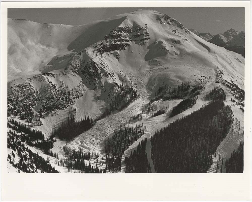
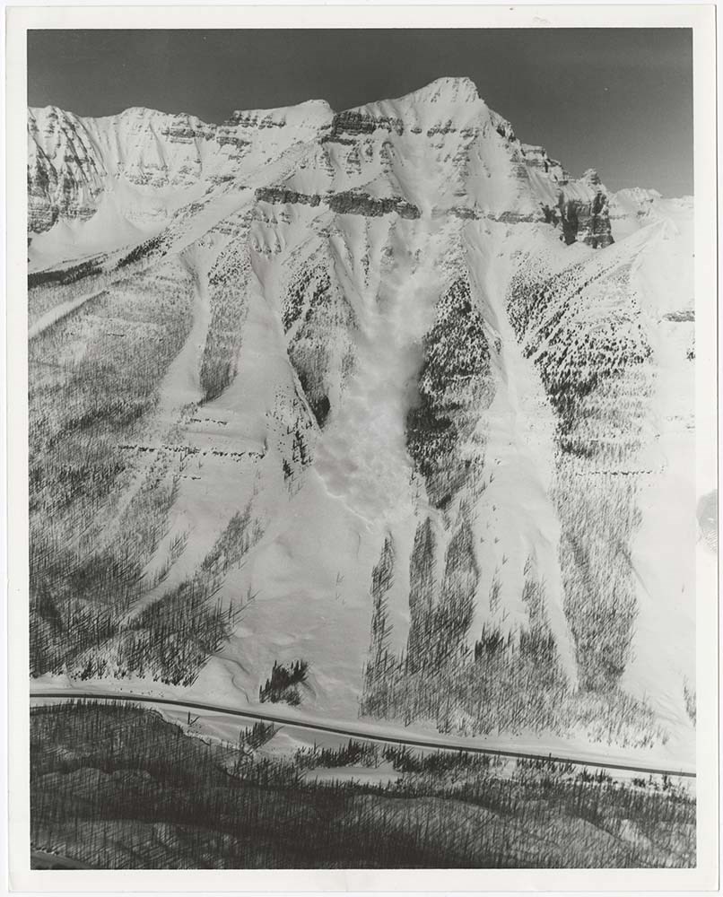
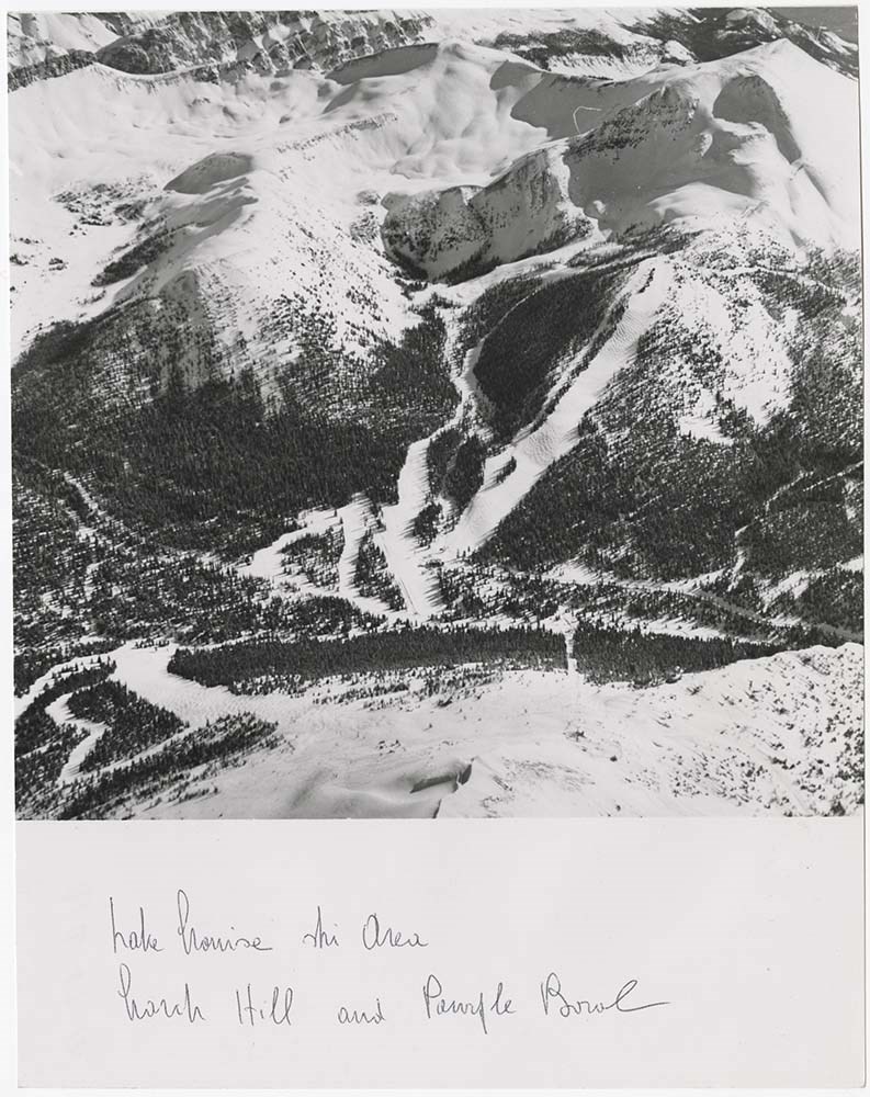
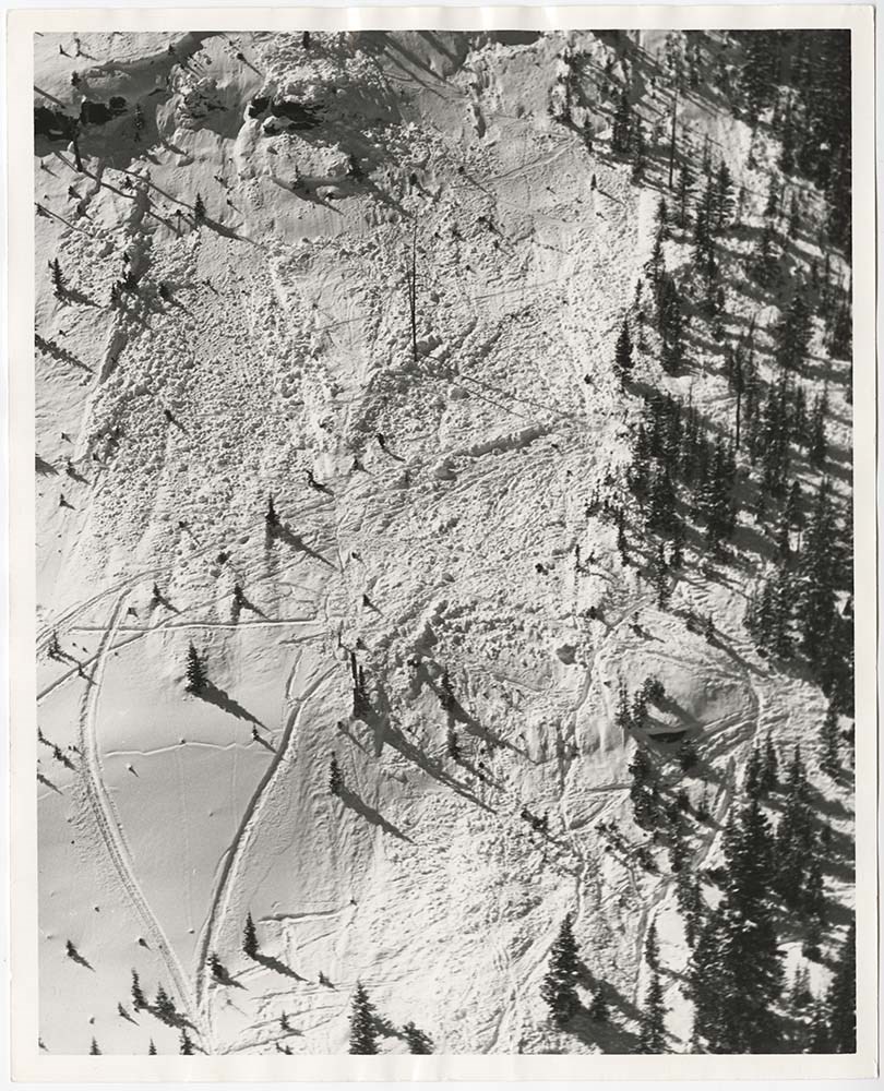
- File pertains to 58 b&w prints of various avalanche areas and slides around Banff National Park, mostly focussed along stretches of highways and in and around ski areas, including backcountry ski areas like Assiniboine.
- Date Range
- [ca. 1977-1990]
- Reference Code
- V190 / VI / A / vi / d / PA - 01 to PA - 58
- Description Level
- 5 / File
- GMD
- Photograph
4 images
- Part Of
- Bruno Engler fonds
- Description Level
- 5 / File
- Fonds Number
- M323 / S40 / V190
- Series
- VI : Retained file, A : Alphabetical order
- Sous-Fonds
- V190
- Sub-Series
- vi : Avalanches, d : Zones
- Accession Number
- 7436
- Reference Code
- V190 / VI / A / vi / d / PA - 01 to PA - 58
- GMD
- Photograph
- Date Range
- [ca. 1977-1990]
- Physical Description
- 58 photographs : b&w ; 20.3 x 25.4 cm or smaller
- History / Biographical
- See fonds level description
- Scope & Content
- File pertains to 58 b&w prints of various avalanche areas and slides around Banff National Park, mostly focussed along stretches of highways and in and around ski areas, including backcountry ski areas like Assiniboine.
- Subject Access
- Aerial photography
- Avalanches
- Banff-Jasper Highway
- Backcountry skiing
- Lake Louise Ski Area
- Mountains
- Ski areas
- Sunshine Ski Resort
- Winter
- Geographic Access
- Banff National Park
- Alberta
- Mount Assiniboine
- Mount Assiniboine Provincial Park
- British Columbia
- Language
- English
- Related Material
- V190 / VI / A / vi / d / NA - 01 to NA - 09
- Creator
- Engler, Bruno
- Title Source
- Original title kept
- Processing Status
- Processed
Images
This material is presented as originally created; it may contain outdated cultural descriptions and
potentially offensive content.
Read more.
Canadian Permanent Committee on Geographical Names
https://archives.whyte.org/en/permalink/descriptions55660
- Part Of
- Maryalice Harvey Stewart fonds
- Scope & Content
- FIle consists of documents pertaining to the Canadian Permanent Committee on Geographical Names collected by Maryalice Harvey Stewart. File includes a list of members of the Committee and their contact information from 1997, which names Maryalice as a "Corresponding Member"; and signed approval doc…
- Date Range
- 1979
- 1989
- 1997
- Reference Code
- M9 / I / B / 16
- Description Level
- 5 / File
- GMD
- Textual record
- Organization record
- Part Of
- Maryalice Harvey Stewart fonds
- Description Level
- 5 / File
- Fonds Number
- M9
- S13
- V605
- Series
- M9 / I : Professional records
- Sous-Fonds
- M9
- Sub-Series
- M9 / I / B : Research and other professional records
- Accession Number
- 3276
- 7412
- Reference Code
- M9 / I / B / 16
- Date Range
- 1979
- 1989
- 1997
- Physical Description
- 0.2 cm of textual records
- Scope & Content
- FIle consists of documents pertaining to the Canadian Permanent Committee on Geographical Names collected by Maryalice Harvey Stewart. File includes a list of members of the Committee and their contact information from 1997, which names Maryalice as a "Corresponding Member"; and signed approval documents for seven renaming decisions, including Castle Mountain (previously named Eisenhower Peak) and six locations in British Columbia.
- Notes
- Most items in file are annotated by Maryalice Harvey Stewart.
- Name Access
- Stewart, Maryalice Harvey
- Subject Access
- Research
- Geography
- Environment
- Mountains
- Laws and legislation
- Government
- Geographic Access
- Canada
- Alberta
- Castle Mountain
- British Columbia
- Canadian Rocky Mountains
- Access Restrictions
- Restrictions may apply - contains personal contact information
- Reproduction Restrictions
- Restrictions may apply - contains personal contact information
- Language
- English
- Category
- Environment
- Government
- Title Source
- Title based on contents of file
- Processing Status
- Processed
This material is presented as originally created; it may contain outdated cultural descriptions and
potentially offensive content.
Read more.
Canadian Rockies
https://archives.whyte.org/en/permalink/descriptions54817
- Part Of
- Murray Hay fonds
- Scope & Content
- File consists of 1 cm of textual records, 10 x 22 cm. File pertains to tourist maps of the Canadian Rocky Mountains created by Murray Hay. File includes a brochure of titled "Canadian Rockies Access Maps" that, when unfolded, includes several maps of the various areas that make up the Canadian Rock…
- Date Range
- ca. 1990 - 1999
- 1999
- Reference Code
- M570 / III / D / i / 2
- Description Level
- 5 / File
- GMD
- Published record
- Map
- Textual record
- Part Of
- Murray Hay fonds
- Description Level
- 5 / File
- Fonds Number
- M570 / V795
- Series
- M570 / III : Murray Hay portfolio (published material)
- Sous-Fonds
- M570
- Sub-Series
- M570 / III / D : Miscellaneous / i : Canada (general)
- Accession Number
- 2019.41
- Reference Code
- M570 / III / D / i / 2
- Date Range
- ca. 1990 - 1999
- 1999
- Physical Description
- 1 cm of textual records (10 x 22 cm)
- Scope & Content
- File consists of 1 cm of textual records, 10 x 22 cm. File pertains to tourist maps of the Canadian Rocky Mountains created by Murray Hay. File includes a brochure of titled "Canadian Rockies Access Maps" that, when unfolded, includes several maps of the various areas that make up the Canadian Rocky Mountains, like Kananaskis Country, Canmore, Banff National Park, Jasper National Park, Yoho National Park, etc.
- Name Access
- Hay, Murray
- Subject Access
- Advertising
- Artist
- Banff
- Banff National Park
- Cartography
- Communications
- Lake Louise
- Kananaskis Country
- Map
- Mountains
- Tourism
- Tourist information
- Travel
- Geographic Access
- Canada
- Canadian Rocky Mountains
- Alberta
- British Columbia
- Yoho National Park
- Jasper National Park
- Banff National Park
- Glacier National Park
- Canmore
- Banff
- Jasper
- Lake Louise
- Kananaskis
- Kananaskis Country
- Kootenay National Park
- Language
- English
- Title Source
- Title based on contents of file
- Processing Status
- Processed
This material is presented as originally created; it may contain outdated cultural descriptions and
potentially offensive content.
Read more.
Chronological Binders: 1996
https://archives.whyte.org/en/permalink/descriptions57571
- Part Of
- Bruno Engler fonds
- Scope & Content
- File pertains to 58 b&w negatives on 10 strips of film depicting various activities that took place during 1996. Includes shots from a productions for a French Canadian program at Assiniboine and a CBC program in Lake Louise, as well as the Canada Day.
- Date Range
- 1996
- Reference Code
- V190 / VI / Z / xx / NA - 01 to NA - 03
- Description Level
- 5 / File
- GMD
- Negative
- Part Of
- Bruno Engler fonds
- Description Level
- 5 / File
- Fonds Number
- M323 / S40 / V190
- Series
- VI : Retained file, Z : Chronological order
- Sous-Fonds
- V190
- Sub-Series
- xx : 1996
- Accession Number
- 7436
- Reference Code
- V190 / VI / Z / xx / NA - 01 to NA - 03
- GMD
- Negative
- Date Range
- 1996
- Physical Description
- 58 photographs : b&w negatives ; 35mm
- History / Biographical
- See fonds level description
- Scope & Content
- File pertains to 58 b&w negatives on 10 strips of film depicting various activities that took place during 1996. Includes shots from a productions for a French Canadian program at Assiniboine and a CBC program in Lake Louise, as well as the Canada Day.
- Notes
- File came from box X, separate from alphabetised boxes. Photographs were ordered chronologically by Engler prior to accessioning.
- Subject Access
- Canada Day
- Films and film making
- Mountains
- Parades
- scenic
- Geographic Access
- Lake Louise
- Banff National Park
- Canmore
- Alberta
- Assiniboine Provincial Park
- British Columbia
- Language
- English
- Creator
- Engler, Bruno
- Title Source
- Original title kept
- Processing Status
- Processed
This material is presented as originally created; it may contain outdated cultural descriptions and
potentially offensive content.
Read more.