Narrow Results By
- Peter Whyte (1905 – 1966, Canadian) 467
- Catharine Robb Whyte, O. C. (1906 – 1979, Canadian) 370
- Les Graff (1936 – , Canadian) 47
- Peter or Catharine Whyte 37
- Carl Clemens Moritz Rungius (1869 – 1959, American) 22
- Sitting Wind (1925 – 2002, Canadian) 19
- John Donaldson Curren (1852 – 1940, Canadian) 17
- Henry George Glyde (1906 – 1998, Canadian) 14
- Unknown 10
- Belmore Browne (1880 – 1954, American) 8
- Charles John Collings (1848 – 1931, British) 8
- Michael Cameron (1955 – , Canadian) 8
- Photograph 29371
- Negative 17287
- Library - Book (including soft-cover and pamphlets) 14314
- Transparency 3187
- Library - Periodical 3157
- Library - Postcard 2944
- Lantern slide 2559
- Textual record 2216
- Map 2131
- Photograph print 2109
- Library - Maps and blueprints (unannotated; published)
- Graphite Drawing 1627
- Date
- 2011
- Medium
- oil on wood
- Catalogue Number
- GuR.02.01
- Description
- A landscape oil painting, on board, of forest on fire. The painting is dominated by one central tree. Fallen tree on fire diagonally across painting in foreground. Background is thick forest on fire and some blue sky with orange smoke. Primarily red, green, blue and yellow color palette. Au verso s…
1 image
- Title
- #4 Wildfires
- Date
- 2011
- Medium
- oil on wood
- Dimensions
- 19.2 x 24.3 cm
- Description
- A landscape oil painting, on board, of forest on fire. The painting is dominated by one central tree. Fallen tree on fire diagonally across painting in foreground. Background is thick forest on fire and some blue sky with orange smoke. Primarily red, green, blue and yellow color palette. Au verso several stickers. At top white with black printing “THIS PAINTING HAS BEEN DONATED TO THE PERMANENT COLLECTION OF THE WHYTE MUSEUM OF THE CANADIAN ROCKIES AT BANFF. IT IS A GIFT FROM THE ARTIST, ROBERT GUEST OF GRANDE CACHE. 2012.” Sticker middle right is yellow with black print, “ CAUTION! HELP AVOID FADING: Display original artwork out of direct sunlight or other strong light, and away from heat or moist conditions!” Bottom left label, white with black printing, “#4. Wildfires./2011” NEW OILPAINT SERIES - 8X10 “ PANELS AT GRANDE CACHE, BY R. GUEST.” Bottom left sticker, blue with black print, see artist bio.
- Subject
- landscape
- forest fire
- Robert Guest
- Credit
- Purchased from Robert Guest, Grande Cache, 2012
- Catalogue Number
- GuR.02.01
Images

This material is presented as originally created; it may contain outdated cultural descriptions and
potentially offensive content.
Read more.
18 Flight Index Maps
https://archives.whyte.org/en/permalink/catalogue21509
- Subjects
- Aerial Photo Maps
- Notes
- Xerox copies
- Accession Number
- 2000
- Call Number
- C12-4
- Collection
- Archives Library
This material is presented as originally created; it may contain outdated cultural descriptions and
potentially offensive content.
Read more.
1978 map of Mount Assiniboine Provincial Park
https://archives.whyte.org/en/permalink/catalogue21315
- Medium
- Library - Maps and blueprints (unannotated; published)
- Map
- Published Date
- 1978 (transfered to manuscrpits Oct. 1994)
- Publisher
- Ministry of Recreation and Conservation
- Call Number
- C2-10.1 (e)
- Publisher
- Ministry of Recreation and Conservation
- Published Date
- 1978 (transfered to manuscrpits Oct. 1994)
- Subjects
- Mount Assiniboine Provincial Park
- Notes
- Descriptive Legend on back of map re: History Winter Activity, Access, Avalanche Safety, Equipment, Trail and Camping Information etc.
- Accession Number
- 11000
- Call Number
- C2-10.1 (e)
- Collection
- Archives Library
This material is presented as originally created; it may contain outdated cultural descriptions and
potentially offensive content.
Read more.
(a): Topographical sheets|(b): Original map
https://archives.whyte.org/en/permalink/catalogue24654
- Medium
- Library - Maps and blueprints (unannotated; published)
- Map
- Published Date
- 1889
- Publisher
- Dept. of the Interior
- Call Number
- C3-8.14 (a)
- C3-8.14 (b)
- Publisher
- Dept. of the Interior
- Published Date
- 1889
- Scale
- Scale:1:40,000
- Relief: Contour interval 100 ft.
- Subjects
- Anthracite
- Notes
- (b): 8 dup in map room
- Accession Number
- 675
- 400
- 3069
- Call Number
- C3-8.14 (a)
- C3-8.14 (b)
- Collection
- Archives Library
This material is presented as originally created; it may contain outdated cultural descriptions and
potentially offensive content.
Read more.
AAF aeronautical chart : North Saskatchewan River / compiled for the U.S. Army Air Forces by the U.S. Coast and Geodetic Survey
https://archives.whyte.org/en/permalink/catalogue24364
- Medium
- Library - Maps and blueprints (unannotated; published)
- Map
- Published Date
- 1943
- Publisher
- Washington, D.C.
- Call Number
- C6-12.1
- Publisher
- Washington, D.C.
- Published Date
- 1943
- Physical Description
- 1 map : col
- Scale
- 1 : 1,000,000
- Subjects
- Saskatchewan River, North
- Aviation
- Accession Number
- 4008
- Call Number
- C6-12.1
- Collection
- Archives Library
This material is presented as originally created; it may contain outdated cultural descriptions and
potentially offensive content.
Read more.
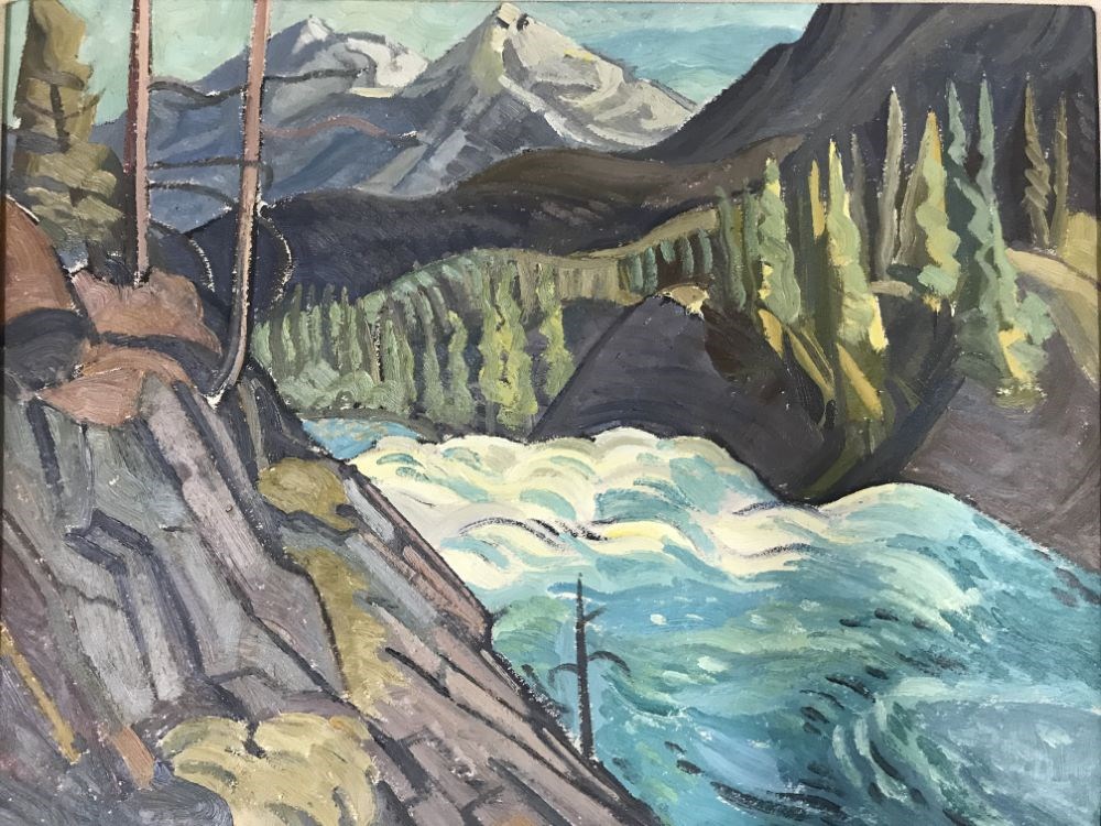
Above Bow Falls
https://archives.whyte.org/en/permalink/artifactgyh.02.15
- Date
- 1952
- Medium
- oil on board
- Catalogue Number
- GyH.02.15
- Description
- A low and wide, white and blue waterfall between gray rocks with evergreen trees mountains in the background.
1 image
- Title
- Above Bow Falls
- Date
- 1952
- Medium
- oil on board
- Dimensions
- 31.0 x 39.0 cm
- Description
- A low and wide, white and blue waterfall between gray rocks with evergreen trees mountains in the background.
- Subject
- Banff
- Bow Falls
- Rocky Mountains
- water
- waterfall
- Credit
- Gift of Fred Burghardt, Edmonton, 2018
- Catalogue Number
- GyH.02.15
Images
This material is presented as originally created; it may contain outdated cultural descriptions and
potentially offensive content.
Read more.
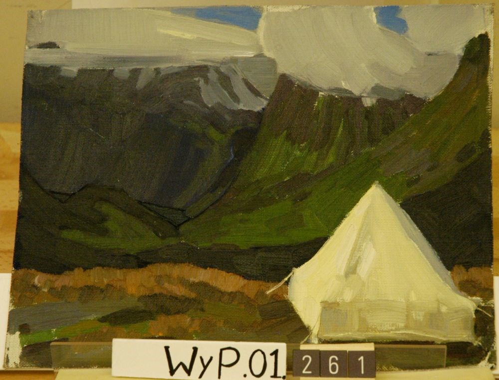
Above Geiranger Fjord, Norway
https://archives.whyte.org/en/permalink/artifactwyp.01.261
- Date
- 1938
- Medium
- oil on canvas
- Catalogue Number
- WyP.01.261
1 image
- Title
- Above Geiranger Fjord, Norway
- Date
- 1938
- Medium
- oil on canvas
- Dimensions
- 27.2 x 34.7 cm
- Credit
- Gift of Catharine Robb Whyte, O. C., Banff, 1979
- Catalogue Number
- WyP.01.261
Images
This material is presented as originally created; it may contain outdated cultural descriptions and
potentially offensive content.
Read more.
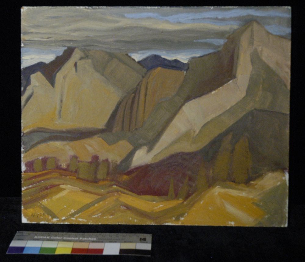
Above the West Road
https://archives.whyte.org/en/permalink/artifactgyh.02.07
- Date
- n.d.
- Medium
- oil on masonite
- Catalogue Number
- GyH.02.07
- Description
- The mountain landscape is painted in shades of brown, yellow, grey and red. The sky is rendered in a light blue with dark grey clouds on the left. The foreground encompasses yellow rolling hills with suggestions of trees on the lower right. Between the mountains and the foreground is a line of burg…
1 image
- Title
- Above the West Road
- Date
- n.d.
- Medium
- oil on masonite
- Dimensions
- 33 x 40.5 cm
- Description
- The mountain landscape is painted in shades of brown, yellow, grey and red. The sky is rendered in a light blue with dark grey clouds on the left. The foreground encompasses yellow rolling hills with suggestions of trees on the lower right. Between the mountains and the foreground is a line of burgundy. On the back “Above the West Road Banff 24 H. G. Glyde.”
- Subject
- landscape
- Canadian Rockies
- mountains
- Credit
- Gift of Henry George Glyde, Victoria, 1997
- Catalogue Number
- GyH.02.07
Images
This material is presented as originally created; it may contain outdated cultural descriptions and
potentially offensive content.
Read more.
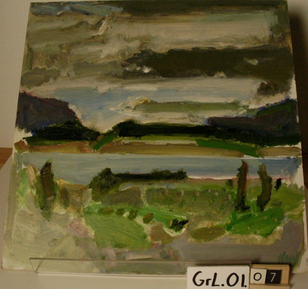
Abraham Lake #3
https://archives.whyte.org/en/permalink/artifactgrl.01.07
- Date
- 2000 – 2000
- Medium
- oil on masonite board
- Catalogue Number
- Grl.01.07
- Description
- An oil sketch of a lake landscape. The primary colours used are green, grey, blue and brown. The sky is dominated with thick grey strokes of colour. Surrounding the water at the top and bottom are thick strokes of green. The blue of the water is a streak across the middle of the work. The artist’s …
1 image
- Title
- Abraham Lake #3
- Date
- 2000 – 2000
- Medium
- oil on masonite board
- Dimensions
- 40.5 x 40.5 cm
- Description
- An oil sketch of a lake landscape. The primary colours used are green, grey, blue and brown. The sky is dominated with thick grey strokes of colour. Surrounding the water at the top and bottom are thick strokes of green. The blue of the water is a streak across the middle of the work. The artist’s signature is in the brhc in green paint.
- Credit
- Gift of Les Graff, Bashaw, 2006
- Catalogue Number
- Grl.01.07
Images
This material is presented as originally created; it may contain outdated cultural descriptions and
potentially offensive content.
Read more.
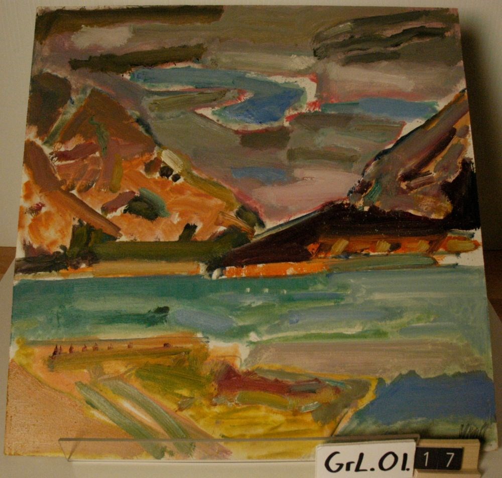
Abraham Lake/East
https://archives.whyte.org/en/permalink/artifactgrl.01.17
- Date
- 2001 – 2001
- Medium
- oil on masonite board
- Catalogue Number
- GrL.01.17
- Description
- An oil sketch of a mountain landscape. The primary colours used are blue, orange, red and brown. The image is composed of a mountain range in the background, with a body of water and a segment of land in the foreground. The artist’s signature is in the brhc in grey paint. Au verso, written in black…
1 image
- Title
- Abraham Lake/East
- Date
- 2001 – 2001
- Medium
- oil on masonite board
- Dimensions
- 40 x 40.5 cm
- Description
- An oil sketch of a mountain landscape. The primary colours used are blue, orange, red and brown. The image is composed of a mountain range in the background, with a body of water and a segment of land in the foreground. The artist’s signature is in the brhc in grey paint. Au verso, written in black ink in the trhc, “45/W”.
- Credit
- Gift of Les Graff, Bashaw, 2006
- Catalogue Number
- GrL.01.17
Images
This material is presented as originally created; it may contain outdated cultural descriptions and
potentially offensive content.
Read more.
Abruzzi, Mount
https://archives.whyte.org/en/permalink/catalogue23436
- Medium
- Library - Maps and blueprints (unannotated; published)
- Map
- Published Date
- Updated from aerial photographs, taken in 1972. Culture check, 1975. Info current as of 1975.
- Publisher
- Surveys and Mapping Branch, Dept. of Energy, Mines and Resources
- Edition
- Edition 2
- Call Number
- NTS
- 82J/6
- Edition
- Edition 2
- Publisher
- Surveys and Mapping Branch, Dept. of Energy, Mines and Resources
- Published Date
- Updated from aerial photographs, taken in 1972. Culture check, 1975. Info current as of 1975.
- Scale
- Scale: 1:50,000
- Subjects
- Mount Abruzzi
- Notes
- National Topographic System
- Complete reference/reverse side of map
- Accession Number
- 9500
- Call Number
- NTS
- 82J/6
- Collection
- Archives Library
This material is presented as originally created; it may contain outdated cultural descriptions and
potentially offensive content.
Read more.
[Abruzzi, Mount 82J/6 East, B.C.]
https://archives.whyte.org/en/permalink/catalogue23438
- Medium
- Library - Maps and blueprints (unannotated; published)
- Map
- Published Date
- 1966
- Publisher
- Dept. of Mines and Technical Surveys
- Call Number
- NTS
- 82J/6E
- Publisher
- Dept. of Mines and Technical Surveys
- Published Date
- 1966
- Physical Description
- 1 map : col
- Scale
- Scale: 1:50,000
- Relief: Contour interval 100'
- Subjects
- Mount Abruzzi
- British Columbia
- Notes
- National Topographic System
- Accession Number
- 718
- Call Number
- NTS
- 82J/6E
- Collection
- Archives Library
This material is presented as originally created; it may contain outdated cultural descriptions and
potentially offensive content.
Read more.
[Abruzzi, Mount 82J/6 West, B.C.]
https://archives.whyte.org/en/permalink/catalogue23437
- Medium
- Library - Maps and blueprints (unannotated; published)
- Map
- Published Date
- 1966
- Publisher
- Dept. of Mines and Technical Surveys
- Call Number
- NTS
- 82J/6W
- Publisher
- Dept. of Mines and Technical Surveys
- Published Date
- 1966
- Physical Description
- 1 map : col
- Scale
- Scale: 1:50,000
- Relief: Contour interval 100'
- Subjects
- Mount Abruzzi
- British Columbia
- Notes
- National Topographic System
- Accession Number
- 718
- Call Number
- NTS
- 82J/6W
- Collection
- Archives Library
This material is presented as originally created; it may contain outdated cultural descriptions and
potentially offensive content.
Read more.
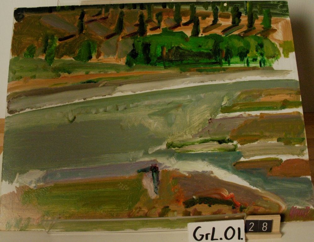
Across the North Saskatchewan River/Shadows
https://archives.whyte.org/en/permalink/artifactgrl.01.28
- Date
- 2003 – 2003
- Medium
- oil on masonite board
- Catalogue Number
- GrL.01.28
- Description
- An oil sketch of a landscape. The primary colours used are green, grey, purple and beige. The upper third of the piece is in green, red and beige, with the shadows of the trees depicted as red lines. The majority of the canvas centre is grey, with a variety of colours on the right centre. The artis…
1 image
- Title
- Across the North Saskatchewan River/Shadows
- Date
- 2003 – 2003
- Medium
- oil on masonite board
- Dimensions
- 35.6 x 40.7 cm
- Description
- An oil sketch of a landscape. The primary colours used are green, grey, purple and beige. The upper third of the piece is in green, red and beige, with the shadows of the trees depicted as red lines. The majority of the canvas centre is grey, with a variety of colours on the right centre. The artist’s signature is in the blhc in purple paint. Au verso, written in black ink in the tlhc, “47/R”.
- Credit
- Gift of Les Graff, Bashaw, 2007
- Catalogue Number
- GrL.01.28
Images
This material is presented as originally created; it may contain outdated cultural descriptions and
potentially offensive content.
Read more.
[Adams Lookout, Alberta]
https://archives.whyte.org/en/permalink/catalogue23439
- Medium
- Library - Maps and blueprints (unannotated; published)
- Map
- Published Date
- 1962
- Publisher
- Dept. of Mines & Technical Surveys
- Call Number
- NTS
- 83E/10E
- Publisher
- Dept. of Mines & Technical Surveys
- Published Date
- 1962
- Scale
- Scale: 1:50,000
- Subjects
- Adams Lookout
- Alberta
- Notes
- National Topographic System
- Accession Number
- 12000
- Call Number
- NTS
- 83E/10E
- Collection
- Archives Library
This material is presented as originally created; it may contain outdated cultural descriptions and
potentially offensive content.
Read more.
[Adams Lookout, Alberta]
https://archives.whyte.org/en/permalink/catalogue23440
- Medium
- Library - Maps and blueprints (unannotated; published)
- Map
- Published Date
- 1962
- Publisher
- Dept. of Mines and Technical Surveys
- Call Number
- NTS
- 83W/10W
- Publisher
- Dept. of Mines and Technical Surveys
- Published Date
- 1962
- Scale
- Scale: 1:50,000
- Subjects
- Adams Lookout
- Alberta
- Notes
- National Topographic System
- Accession Number
- 12000
- Call Number
- NTS
- 83W/10W
- Collection
- Archives Library
This material is presented as originally created; it may contain outdated cultural descriptions and
potentially offensive content.
Read more.
[Adams Plateau 82M/4 East, B.C.]
https://archives.whyte.org/en/permalink/catalogue23441
- Medium
- Library - Maps and blueprints (unannotated; published)
- Map
- Published Date
- 1961
- Publisher
- Department of Mines and Technical Surveys
- Call Number
- NTS
- 82M/4E
- Publisher
- Department of Mines and Technical Surveys
- Published Date
- 1961
- Physical Description
- 1 map : col
- Scale
- Scale: 1:50,000
- Relief: Contour interval 100 ft.
- Subjects
- Adams Plateau
- British Columbia
- Notes
- National Topographic System
- Accession Number
- 7000
- Call Number
- NTS
- 82M/4E
- Collection
- Archives Library
This material is presented as originally created; it may contain outdated cultural descriptions and
potentially offensive content.
Read more.
[Adams Plateau 82M/4 West, B.C.]
https://archives.whyte.org/en/permalink/catalogue23442
- Medium
- Library - Maps and blueprints (unannotated; published)
- Map
- Published Date
- 1961
- Publisher
- Department of Mines and Technical Surveys
- Call Number
- NTS
- 82M/4W
- Publisher
- Department of Mines and Technical Surveys
- Published Date
- 1961
- Physical Description
- 1 map : col
- Scale
- Scale: 1:50,000
- Relief: Contour interval 100 ft.
- Subjects
- Adams Plateau
- British Columbia
- Notes
- National Topographic System
- Accession Number
- 7000
- Call Number
- NTS
- 82M/4W
- Collection
- Archives Library
This material is presented as originally created; it may contain outdated cultural descriptions and
potentially offensive content.
Read more.
[Adams River 82M/11 East, B.C.]
https://archives.whyte.org/en/permalink/catalogue23443
- Medium
- Library - Maps and blueprints (unannotated; published)
- Map
- Published Date
- 1961
- Publisher
- Dept. of Mines and Technical Surveys
- Call Number
- NTS
- 82M/11E
- Publisher
- Dept. of Mines and Technical Surveys
- Published Date
- 1961
- Physical Description
- 1 map : col
- Scale
- Scale: 1:50,000
- Relief: Contour interval 100 ft.
- Subjects
- Adams River
- British Columbia
- Notes
- National Topographic System
- Accession Number
- 3000
- Call Number
- NTS
- 82M/11E
- Collection
- Archives Library
This material is presented as originally created; it may contain outdated cultural descriptions and
potentially offensive content.
Read more.
[Adams River 82M/11 West, B.C.]
https://archives.whyte.org/en/permalink/catalogue23444
- Medium
- Library - Maps and blueprints (unannotated; published)
- Map
- Published Date
- 1961
- Publisher
- Dept. of Mines and Technical Surveys
- Call Number
- NTS
- 82M/11W
- Publisher
- Dept. of Mines and Technical Surveys
- Published Date
- 1961
- Physical Description
- 1 map : col
- Scale
- Scale: 1:50,000
- Relief: Contour interval 100 ft.
- Subjects
- Adams River
- British Columbia
- Notes
- National Topographic System
- Accession Number
- 3000
- Call Number
- NTS
- 82M/11W
- Collection
- Archives Library
This material is presented as originally created; it may contain outdated cultural descriptions and
potentially offensive content.
Read more.