Narrow Results By
- Hay, Murray 12
- Gadd, Ben 4
- Hembroff MacDonald, Jean 4
- Fisher, George 2
- Morant, Nicholas 2
- Nicholas Morant 2
- A.O. Wheeler 1
- Alpine Club of Canada 1
- Canadian Government, Government of Alberta, Government of Ontario, Canadian Pacific, National Parks of Canada 1
- Cran, Anna 1
- Geddes, Malcolm 1
- Gibbon, John Murray 1
Deep Powder and Steep Rock - textual
https://archives.whyte.org/en/permalink/descriptions55082
- Part Of
- Chic Scott fonds
- Scope & Content
- Series consists of textual records, including notes, manuscripts and other related materials, pertaining to the creation of the book "Deep Powder and Steep Rock".
- Date Range
- 2009
- Reference Code
- M57 / V
- Description Level
- 3 / Series
- GMD
- Textual record
- Map
- Part Of
- Chic Scott fonds
- Description Level
- 3 / Series
- Fonds Number
- M57 / V40 / S47
- Series
- M57 / V : Deep Powder and Steep Rock
- Sous-Fonds
- M57
- Accession Number
- 2014.8295
- 2015.8559
- Reference Code
- M57 / V
- GMD
- Textual record
- Map
- Date Range
- 2009
- Physical Description
- 30 cm of textual records
- History / Biographical
- Hans Gmoser played a major role in creating Canada’s vibrant mountain community. Although known internationally as the father of heli-skiing, he was much more than that: a talented rock climber, tireless expedition leader, a mountain guide, film maker and organizer. Deep Powder and Steep Rock presents an intimate portrait of this charismatic man. Much of the story is told in Gmoser’s own words, gleaned from his diaries, expedition journals, film commentaries and personal correspondence. It is a unique tale of adventure, hard work, perseverance and ultimate success.
- Scope & Content
- Series consists of textual records, including notes, manuscripts and other related materials, pertaining to the creation of the book "Deep Powder and Steep Rock".
- Notes
- Series consists of five sub-series: M57 / V / A: Research files M57 / V / B: Maps M57 / V / C: Interviews M57 / V / D: Photograph notes M57 / V / E: Draft Manuscript
- Name Access
- Scott, Chic
- Gmoser, Hans
- Subject Access
- Biography
- Personal and Professional Life
- Publication
- Research
- Geography
- Map
- Mountaineers
- Mountaineering
- Skiing
- Sports
- Recreation
- Winter sports
- Canadian Mountain Holidays
- Helicopter skiing
- Tourism
- Climbing
- Geographic Access
- Canada
- Alberta
- Banff
- Banff National Park
- Canadian Rocky Mountains
- Language
- English
- Related Material
- S47 / V
- V40 / V
- Biographical Source Notes
- http://chicscott.com/books.htm
- Title Source
- Title based on contents of file
- Processing Status
- Processed
This material is presented as originally created; it may contain outdated cultural descriptions and
potentially offensive content.
Read more.
The Selkirk Range Text and Maps
https://archives.whyte.org/en/permalink/descriptions54163
- Part Of
- Nicholas Morant fonds
- Scope & Content
- File consists of 2 volumes, 1 textual and 1 cartographic, from 'The Selkirk Range British Columbia'. Volume 1 pertains to a textual account of the Selkirk region; volume 2 pertains to a collection of various topographical maps of the Selkirk region. Volume 1 is signed by Emmeline Wheeler.
- Date Range
- 1951
- Reference Code
- M300 / III / D / 5 / 52 to 53
- Description Level
- 5 / File
- GMD
- Textual record
- Private record
- Map
- Part Of
- Nicholas Morant fonds
- Description Level
- 5 / File
- Fonds Number
- M300 / S20 / V500
- Sous-Fonds
- M300
- Sub-Series
- M300 / III / D / 5 : Personal Interest and Gifts
- Accession Number
- 7784
- Reference Code
- M300 / III / D / 5 / 52 to 53
- Responsibility
- Produced by A.O. Wheeler
- Date Range
- 1951
- Physical Description
- Textual record: book & Cartographic records: maps
- Scope & Content
- File consists of 2 volumes, 1 textual and 1 cartographic, from 'The Selkirk Range British Columbia'. Volume 1 pertains to a textual account of the Selkirk region; volume 2 pertains to a collection of various topographical maps of the Selkirk region. Volume 1 is signed by Emmeline Wheeler.
- Storage Range
- In file box M300 / III / D / 5 / 52 to M300 / III / D / 5 / 53.
- Name Access
- Wheeler, A.O.
- Geographic Access
- Canada
- Canadian Rocky Mountains
- Selkirks
- Access Restrictions
- Items in this file are not to be accessed or distributed without the explicit permission of their identified copyright owners.
- Reproduction Restrictions
- Items in this file are not to be reproduced without the explicit permission of their identified copyright owners.
- Language
- English
- Creator
- A.O. Wheeler
- Title Source
- Title based on contents of file
- Processing Status
- Processed
This material is presented as originally created; it may contain outdated cultural descriptions and
potentially offensive content.
Read more.
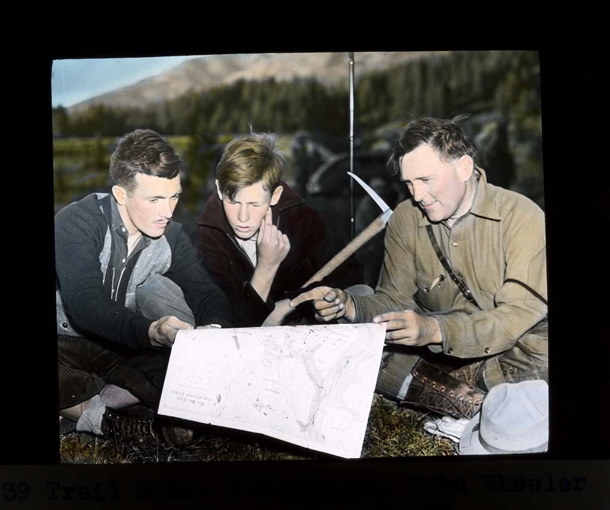
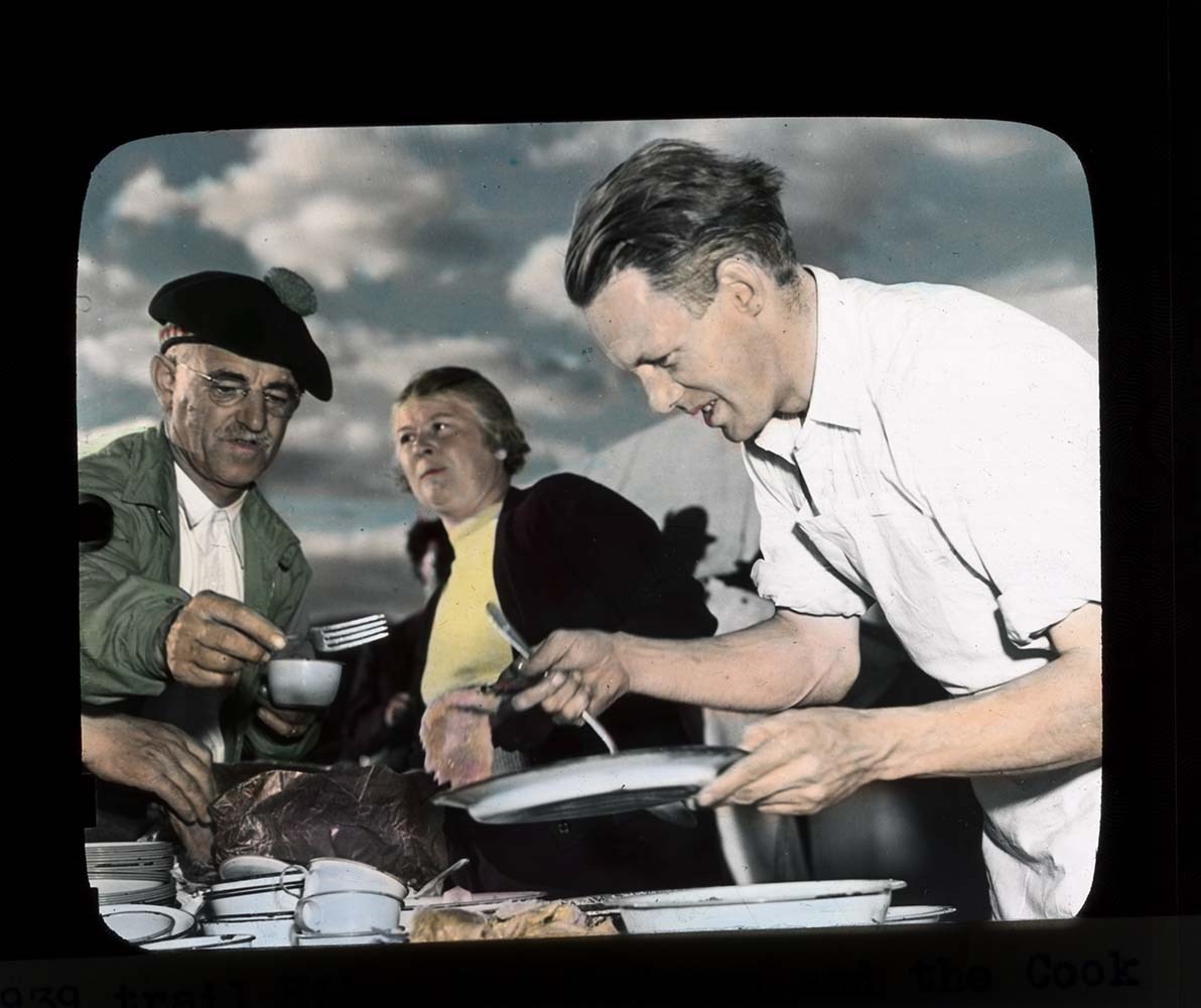
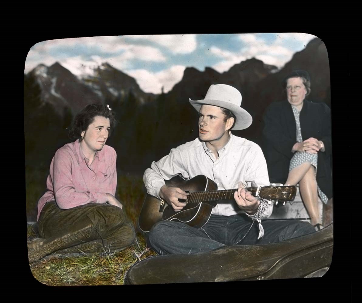
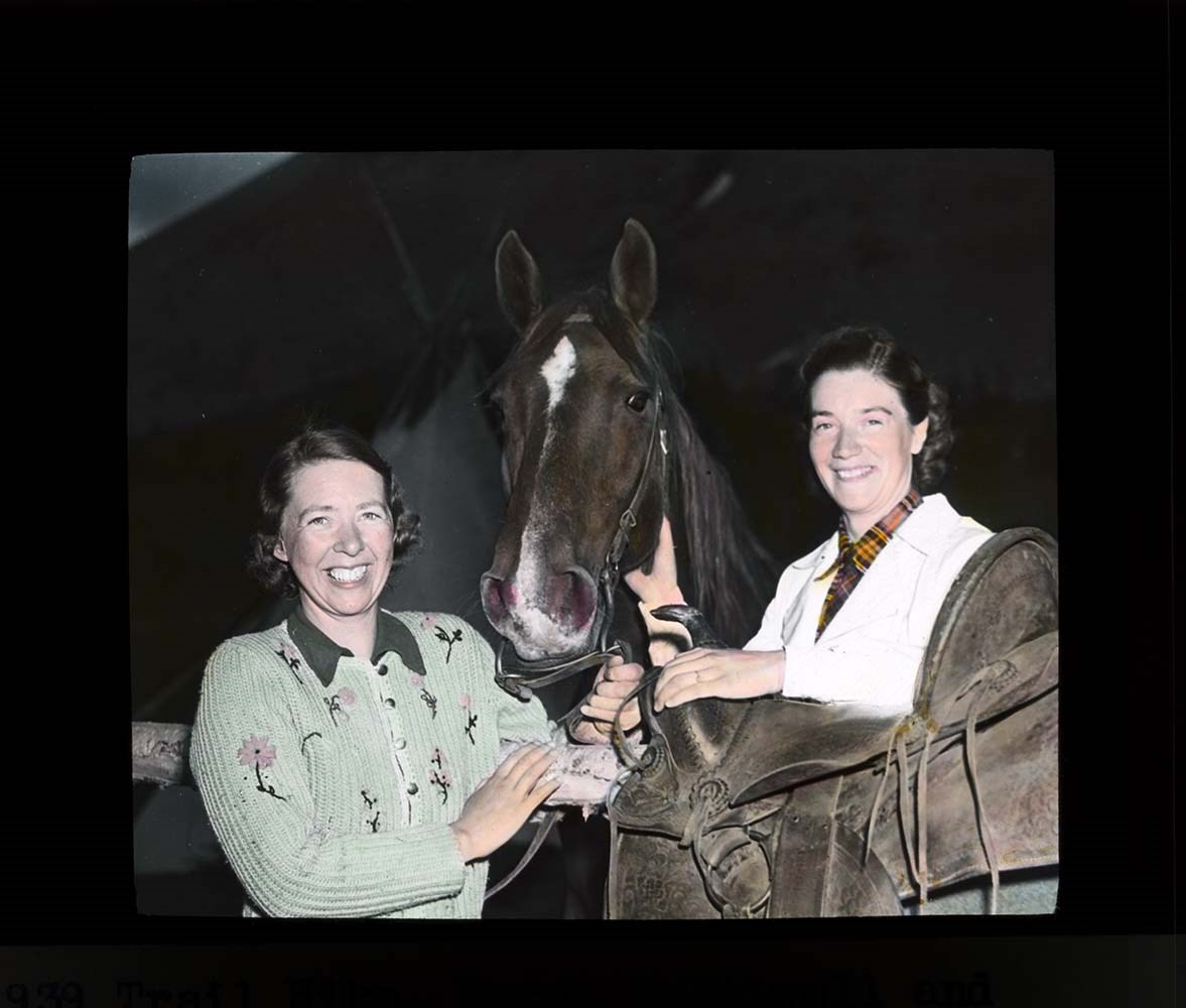
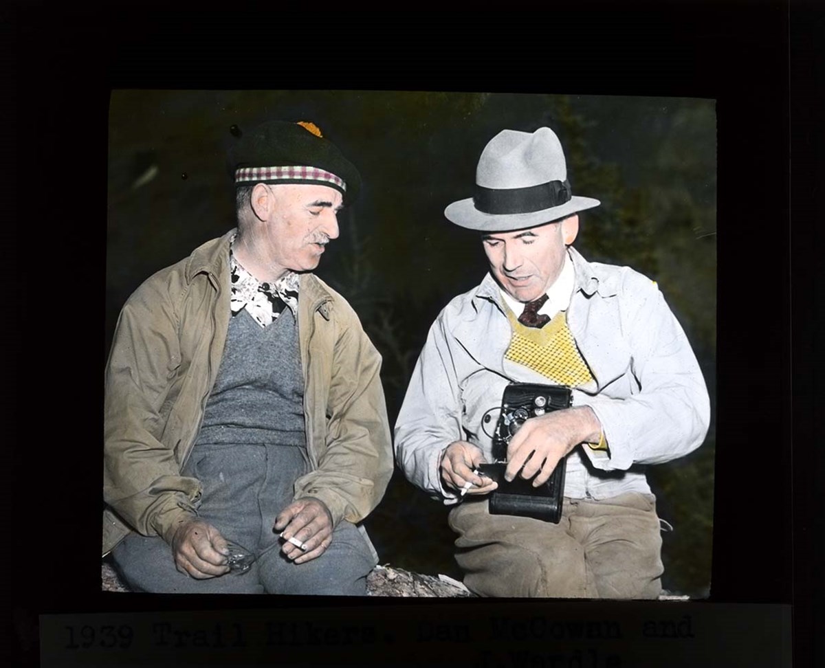
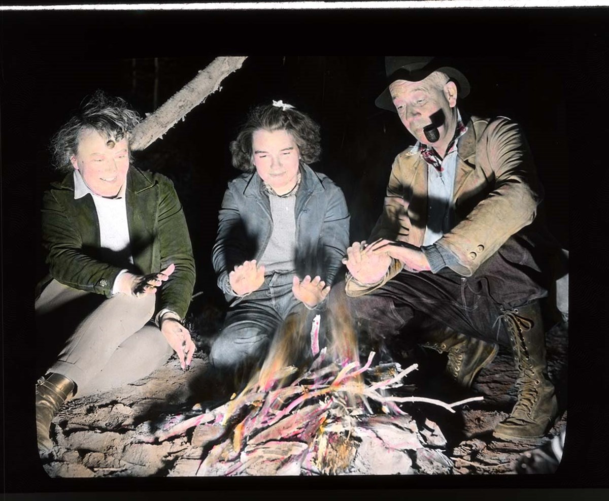
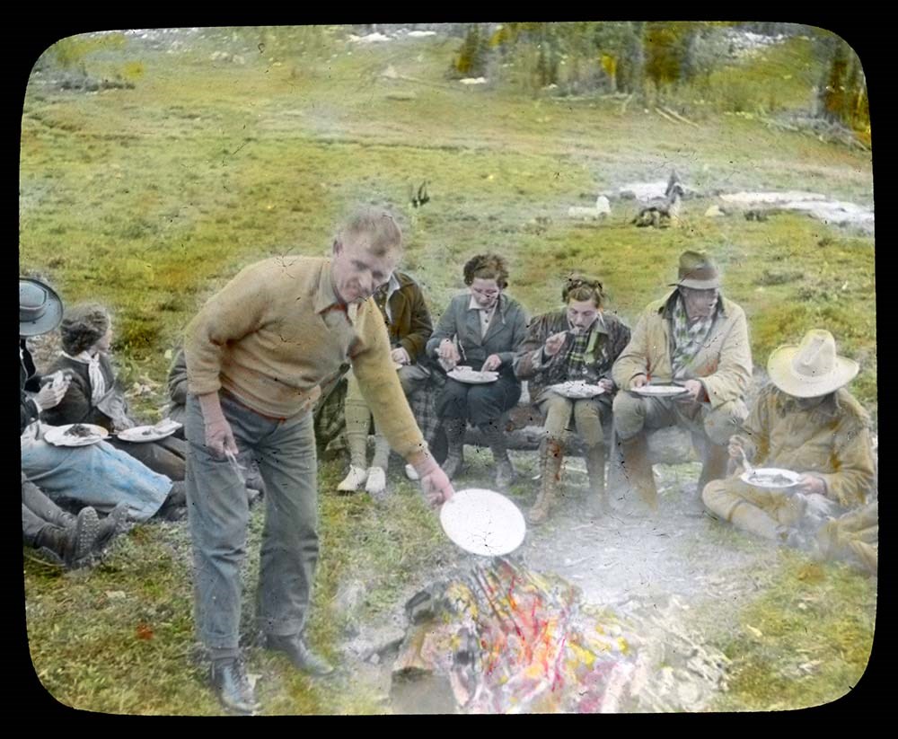
Trail Ride of 1939
https://archives.whyte.org/en/permalink/descriptions54698
- Part Of
- Jean A. Hembroff MacDonald fonds
- Scope & Content
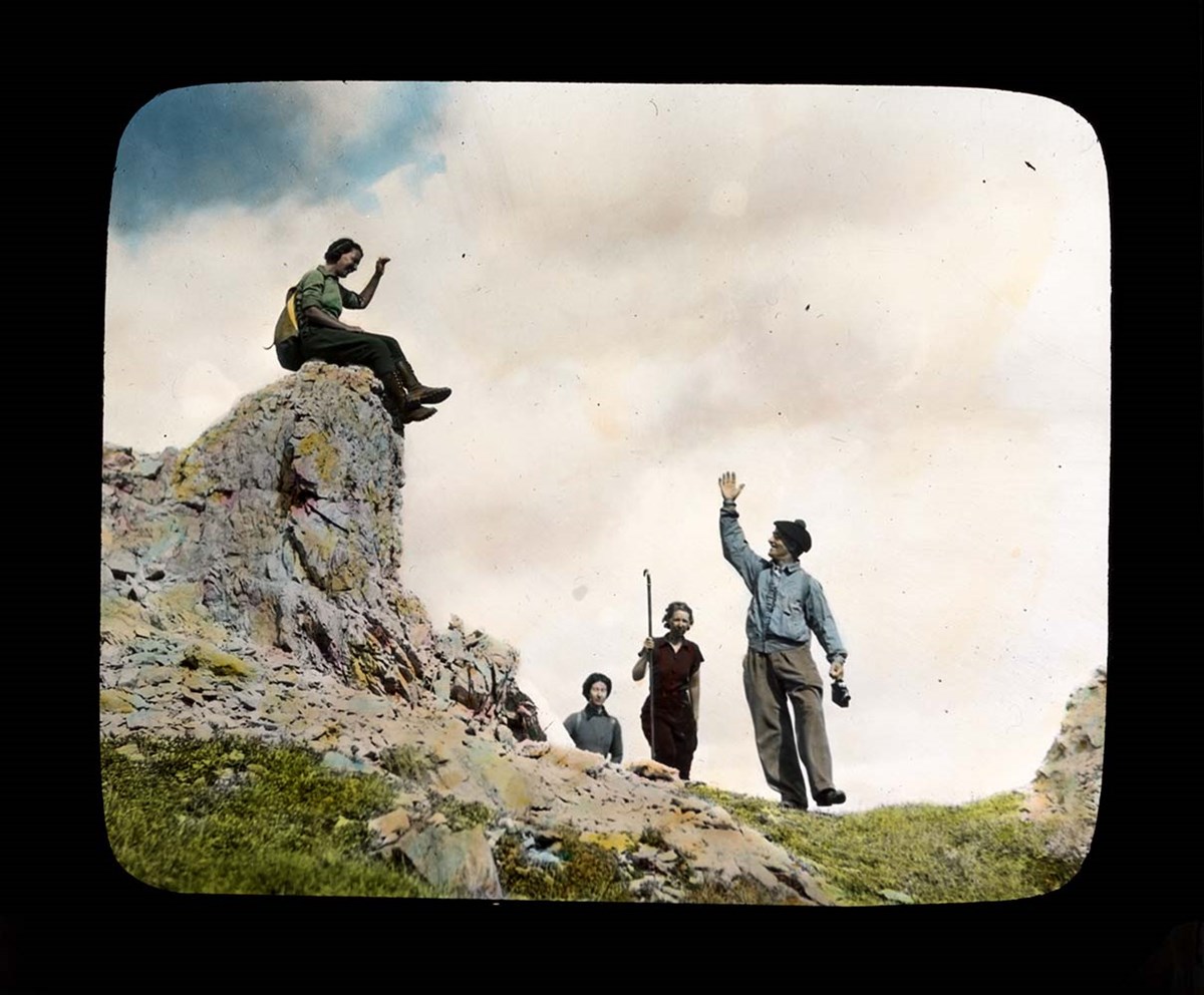
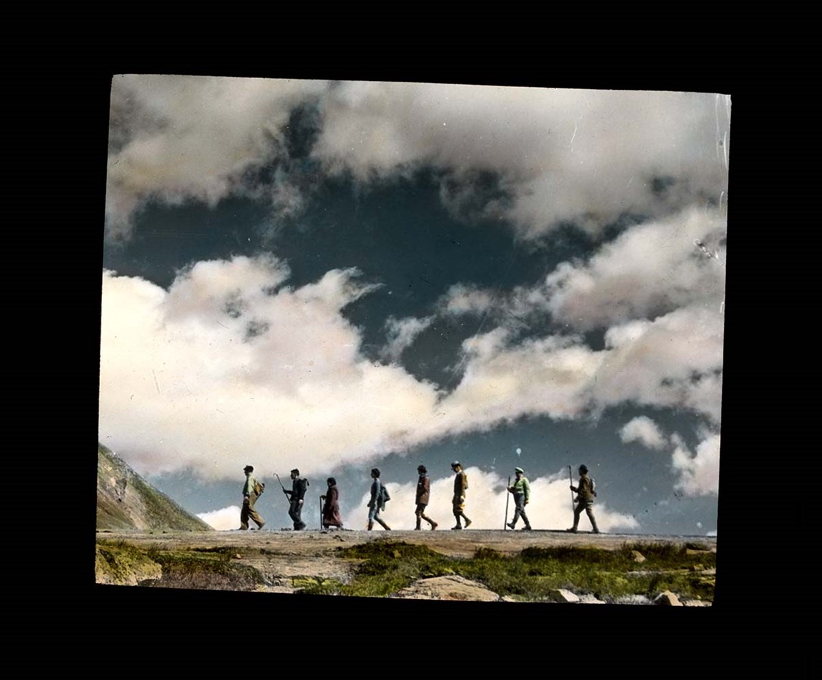
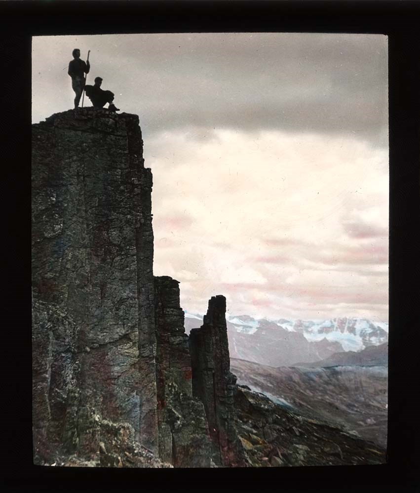
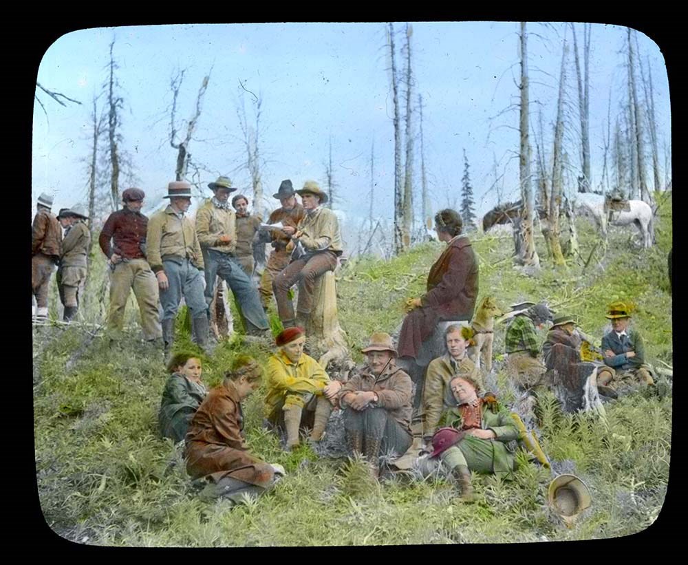
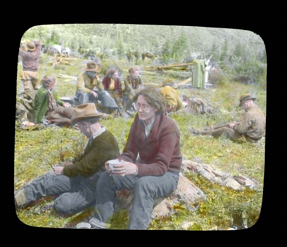
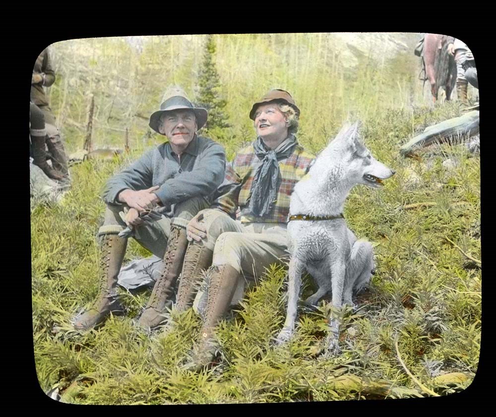
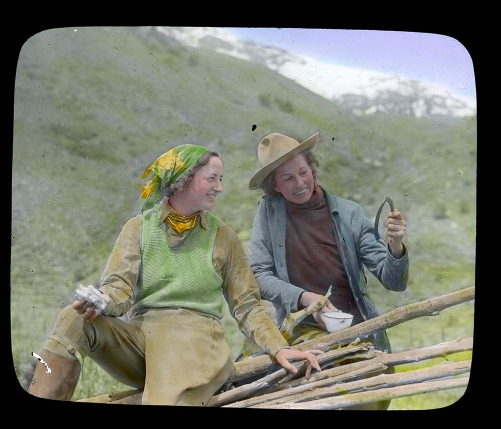
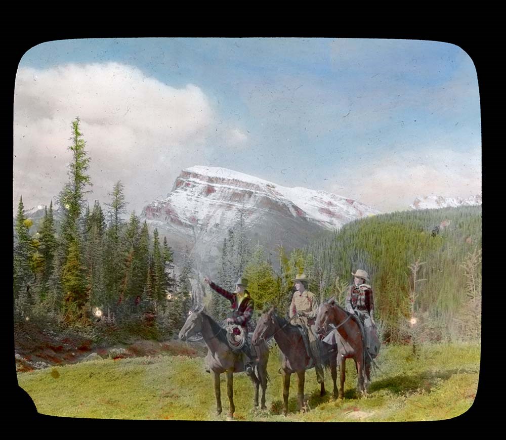
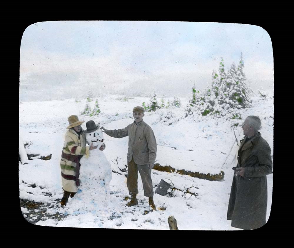
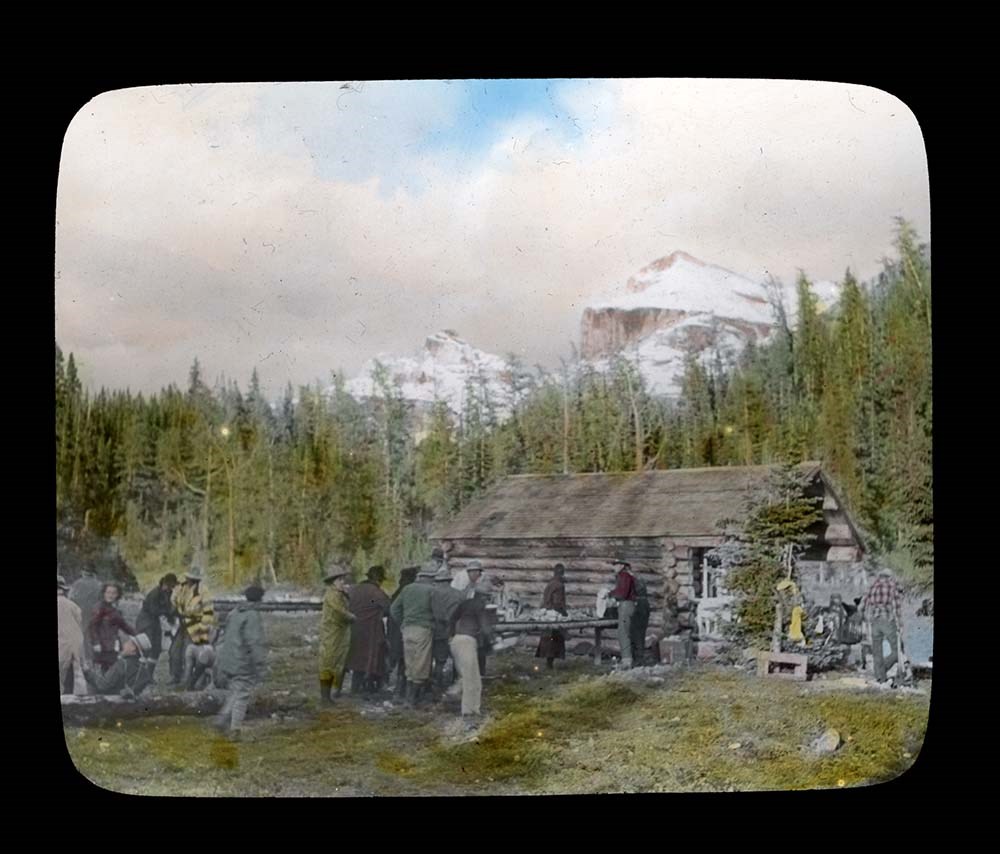
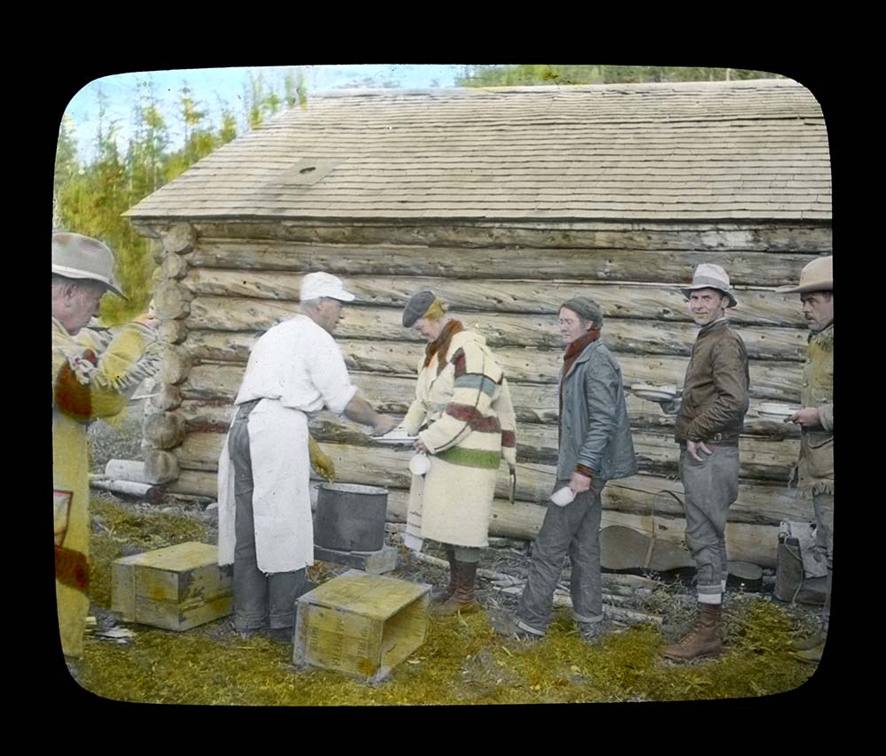
- File consists of 33 colour photograph transparencies (lantern slides). File documents the official trail ride of the Skyline Trail Hikers of the Canadian Rockies, which Jean Hembroff MacDonald participated in. File pertains to the Ptarmigan Valley Camp, with landscape scenery and photographs of the…
- Date Range
- 1939
- Reference Code
- V797 / II / PS - 28 to 60
- Description Level
- 5 / File
- GMD
- Transparency
- Photograph
- Lantern slide
33 images
- Part Of
- Jean A. Hembroff MacDonald fonds
- Description Level
- 5 / File
- Fonds Number
- M573 / V797 / S60
- Series
- V797 / II : Lantern Slides
- Sous-Fonds
- V797
- Accession Number
- 2019.111
- Reference Code
- V797 / II / PS - 28 to 60
- Date Range
- 1939
- Physical Description
- 33 photographs : col. slides
- Scope & Content
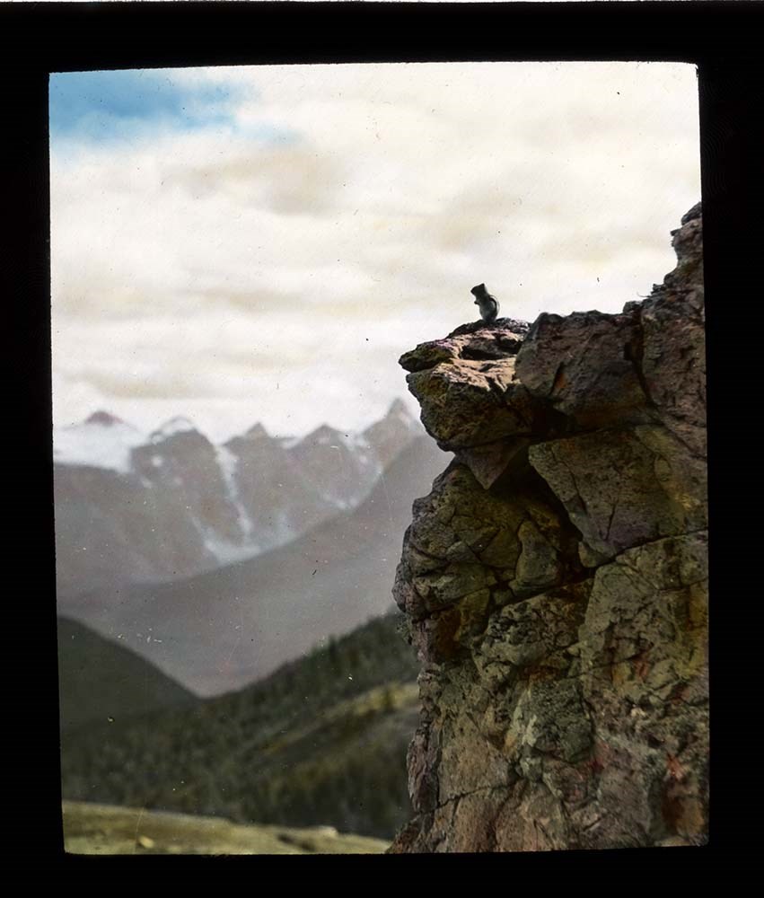
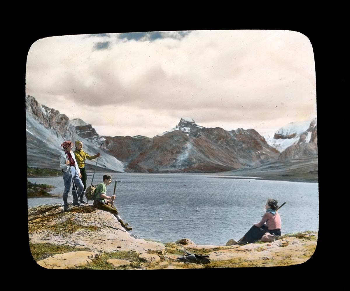
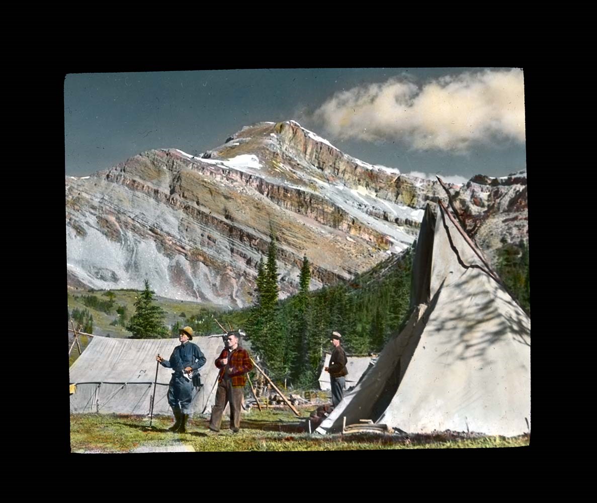
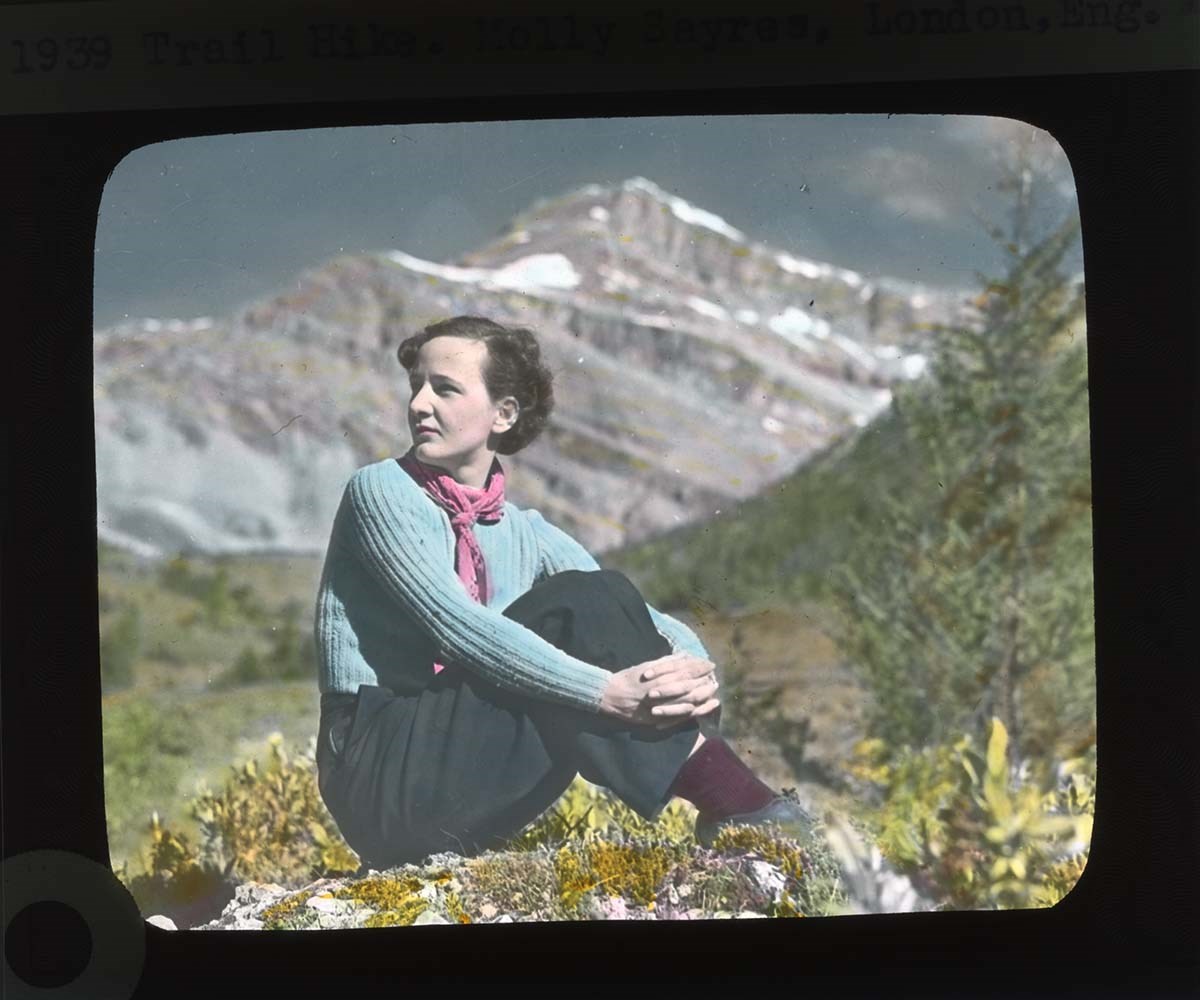
- File consists of 33 colour photograph transparencies (lantern slides). File documents the official trail ride of the Skyline Trail Hikers of the Canadian Rockies, which Jean Hembroff MacDonald participated in. File pertains to the Ptarmigan Valley Camp, with landscape scenery and photographs of the hikers (singing, eating, etc). Places that are documented in this file are the Redoubt Lake trail, Hidden Lake, Ptarmigan Lake, Boulder Pass, and Skoki. Notable people include Jean Hembroff MacDonald, her husband, Jack MacDonald, and sister-in-law, Anna Cran; Dan McCowan; James M. Wardle; George Fisher; Norman Sanson; Betsy Struthers; and Emmeline Savatard and John Wheeler (A.O. Wheeler's wife and grandson).
- Notes
- Each slide is labelled.
- Jean wrote an article about her experience [see related material], and used this experience for future lectures
- Slides were stored with a note stating: "Slides taken by the C.P.R. of Trail Ride, 1936-1937."
- Name Access
- Hembroff MacDonald, Jean
- Wardle, James M.
- McCowan, Dan
- Sanson, Norman
- MacDonald, Jack
- Cran, Anna
- Savatard, Emmeline
- Struthers, Betsy
- Fisher, George
- Wheeler, John Oliver
- Subject Access
- Skyline Hikers of the Canadian Rockies
- Trails
- Trail guides
- Tourism
- Travel
- Hiking
- Horse packing
- Horseback riding
- Horses
- Geographic Access
- Banff National Park
- Canada
- Canadian Rocky Mountains
- Lake Louise
- Skoki
- Language
- English
- Related Material
- M573 / I / 18
- The Sky Line Trail, Vol. 6, No. 24 (October 1939)
- Title Source
- Title based on contents of file
- Processing Status
- Processed
Images


This material is presented as originally created; it may contain outdated cultural descriptions and
potentially offensive content.
Read more.
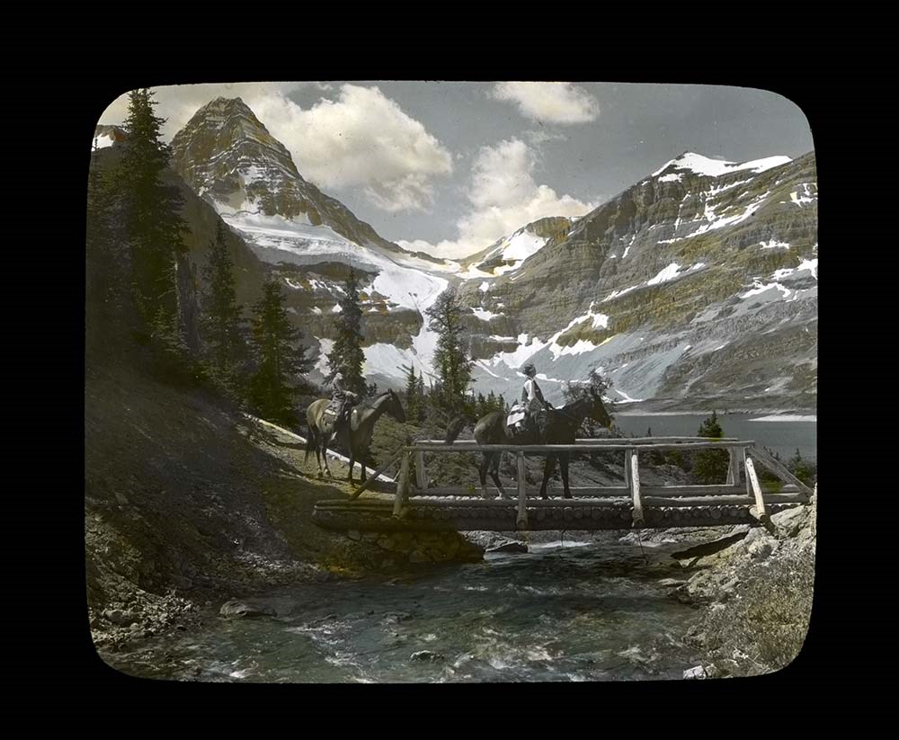
Trail Ride of 1937
https://archives.whyte.org/en/permalink/descriptions54697
- Part Of
- Jean A. Hembroff MacDonald fonds
- Scope & Content
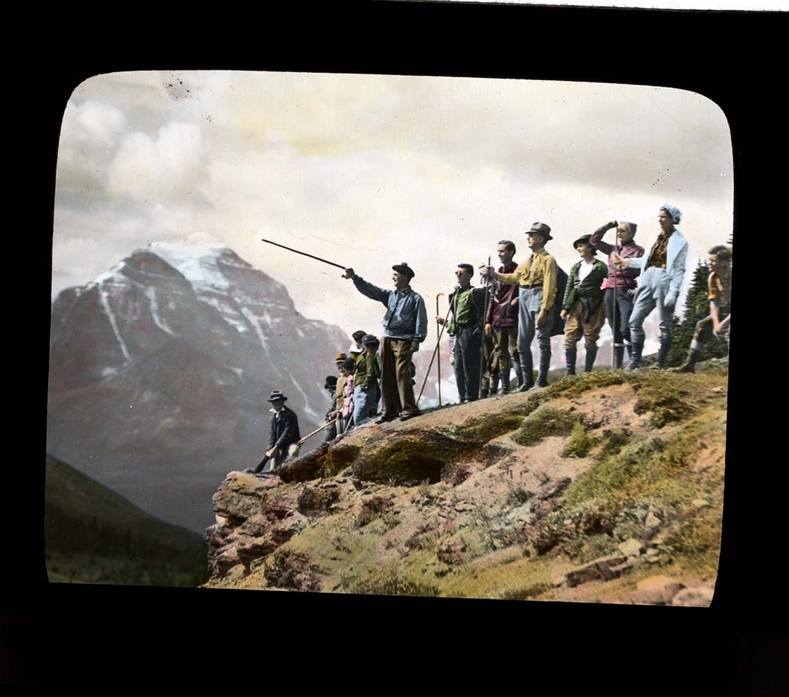
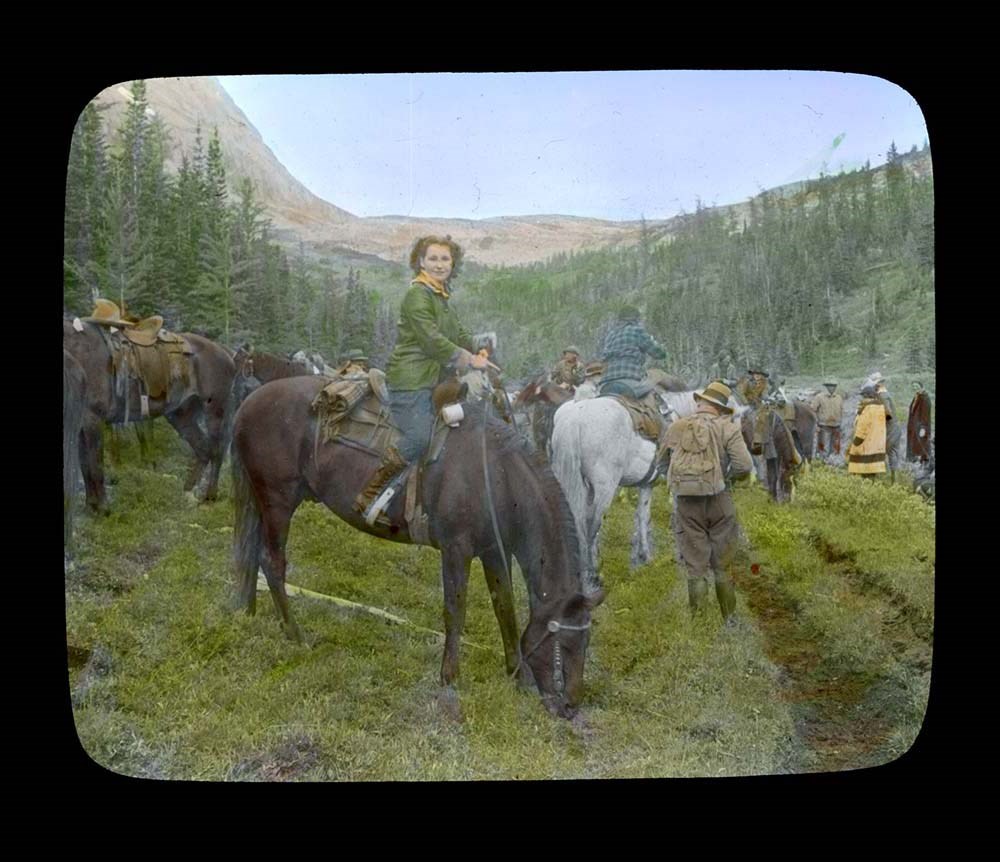
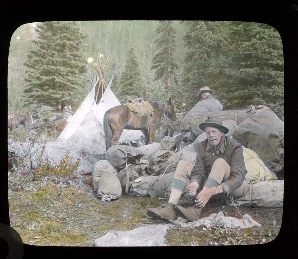
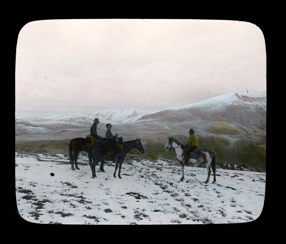
- File consists of 27 colour photograph transparencies (lantern slides). File pertains to the Official Trail Ride of 1937 organized by the Trail Riders of the Canadian Rockies, which Jean Hembroff MacDonald participated in. File documents the trail ride to Mount Assiniboine and the camp at Mount Assi…
- Date Range
- 1937
- Reference Code
- V797 / II / PS - 1 to 27
- Description Level
- 5 / File
- GMD
- Lantern slide
- Photograph
- Transparency
27 images
- Part Of
- Jean A. Hembroff MacDonald fonds
- Description Level
- 5 / File
- Fonds Number
- M573 / V797 / S60
- Series
- V797 / II : Lantern Slides
- Sous-Fonds
- V797
- Accession Number
- 2019.111
- Reference Code
- V797 / II / PS - 1 to 27
- Date Range
- 1937
- Physical Description
- 27 photographs : col. slides
- Scope & Content
- File consists of 27 colour photograph transparencies (lantern slides). File pertains to the Official Trail Ride of 1937 organized by the Trail Riders of the Canadian Rockies, which Jean Hembroff MacDonald participated in. File documents the trail ride to Mount Assiniboine and the camp at Mount Assiniboine, with several landscape photographs but mostly of the hikers.
- Notes
- Jean wrote an article about her experience in the form of an article and a poem [see related material], and used this experience for future lectures.
- Slides are numbered on the back. Some are missing, the new number and order was imposed by Archive and Library Assistant for clarity.
- Slides were stored with a note stating: "Slides taken by the C.P.R. of Trail Ride, 1936-1937."
- Name Access
- Hembroff MacDonald, Jean
- Rungius, Carl
- Fisher, George
- Subject Access
- Trail Riders of the Canadian Rockies
- Hiking
- Mount Assiniboine
- Travel
- Tourism
- Trail guides
- Trails
- Horse packing
- Horseback riding
- Horses
- Geographic Access
- British Columbia
- Alberta
- Great Divide
- Mount Assiniboine
- Mount Assiniboine Park
- Canada
- Canadian Rocky Mountains
- Language
- English
- Related Material
- M573 / I / 18
- Trail Riders of the Canadian Rockies, Bulletin No. 48 (October 1937)
- Title Source
- Title based on contents of file
- Processing Status
- Processed
Images


This material is presented as originally created; it may contain outdated cultural descriptions and
potentially offensive content.
Read more.
Banff National Park (general)
https://archives.whyte.org/en/permalink/descriptions55338
- Part Of
- Murray Hay fonds
- Scope & Content
- File consists of 4 prings : col. 35.1 x 24.8 cm or smaller and 4 maps (2 paper, 2 overlays) : col., on mylar ; 60.4 x 30. cm or smaller. File pertains to aerial views of Banff National Park, showing the towns of Banff and Lake Louise, ski hills (Norqay Ski Hill, Sunshine Village, and Lake Louise Sk…
- Date Range
- ca.1976-ca.2000
- Reference Code
- V795 / II / B / v / 1-2
- Description Level
- 5 / File
- GMD
- Map
- Private record
- Part Of
- Murray Hay fonds
- Description Level
- 5 / File
- Fonds Number
- M570 / V795
- Series
- V795 / II : Unpublished Material
- Sous-Fonds
- V795
- Sub-Series
- V795 / II / B : Alberta / v : Banff National Park
- Accession Number
- 2019.41
- Reference Code
- V795 / II / B / v / 1-2
- GMD
- Map
- Private record
- Date Range
- ca.1976-ca.2000
- Physical Description
- 4 prints : col. 35.1 x 24.8 cm or smaller
- 4 maps (2 paper, 2 overlays) : col., annotations, on mylar ; 60.4 x 30. cm or smaller
- Scope & Content
- File consists of 4 prings : col. 35.1 x 24.8 cm or smaller and 4 maps (2 paper, 2 overlays) : col., on mylar ; 60.4 x 30. cm or smaller. File pertains to aerial views of Banff National Park, showing the towns of Banff and Lake Louise, ski hills (Norqay Ski Hill, Sunshine Village, and Lake Louise Ski Resort), as well as other georgraphic features. The mylar overlays contain various amounts of detail and annotations - one consists of a dark red sheet overlayed with place names in negative.
- Notes
- Items not in oversize stored in downstairs vault.
- Name Access
- Hay, Murray
- Subject Access
- Advertising
- Artist
- Ski Maps
- Map
- Cartography
- Sports and recreation
- Tourism
- Tourist information
- Winter
- Winter sports
- Ski area
- Sunshine Village
- Norquay Ski Hill
- Lake Louise Ski Area
- Geographic Access
- Banff
- Lake Louise
- Banff National Park
- Alberta
- Canada
- Canadian Rocky Mountains
- Language
- English
- Creator
- Hay, Murray
- Title Source
- Title based on contents of file
- Processing Status
- Processed
This material is presented as originally created; it may contain outdated cultural descriptions and
potentially offensive content.
Read more.
Rocky Mountains Park topographical map
https://archives.whyte.org/en/permalink/descriptions55707
- Part Of
- Luxton family fonds
- Scope & Content
- File consists of one printed map on canvas depicting Rocky Mountains Park and surrounding areas, ca.1910-1930. Map is annotated with red hand-coloured markers and small notes written in black ink.
- Date Range
- [ca.1910-1930]
- Reference Code
- LUX / III / D / 38 (oversize)
- Description Level
- 5 / File
- GMD
- Map
- Part Of
- Luxton family fonds
- Description Level
- 5 / File
- Fonds Number
- LUX
- Series
- LUX / III / D : Other material
- Sous-Fonds
- LUX / III : Luxton family sous-fonds
- Accession Number
- LUX
- Reference Code
- LUX / III / D / 38 (oversize)
- GMD
- Map
- Date Range
- [ca.1910-1930]
- Physical Description
- 1 topographical map : hand col., annotations, on canvas ; 150 x 100 cm
- History / Biographical
- Rocky Mountains Park was renamed Banff National Park on May 30, 1930 as part of the National Parks Act passed by the Government of Canada.
- Scope & Content
- File consists of one printed map on canvas depicting Rocky Mountains Park and surrounding areas, ca.1910-1930. Map is annotated with red hand-coloured markers and small notes written in black ink.
- Notes
- Context of map mostly unknown. Missing title, date and other identifying information.
- Subject Access
- Map
- Geography
- Landscapes
- Parks
- Geographic Access
- Canada
- Alberta
- Canadian Rocky Mountains
- Access Restrictions
- Map is difficult to handle due to size and condition. Assistance from archival staff required for physical access
- Language
- English
- Conservation
- Use nitrile gloves while handling map
- Biographical Source Notes
- http://parkscanadahistory.com/publications/national-parks-act-1930.htm
- Title Source
- Title based on contents of file
- Processing Status
- Processed
This material is presented as originally created; it may contain outdated cultural descriptions and
potentially offensive content.
Read more.
Travel guides - Canadian Rockies, Montana
https://archives.whyte.org/en/permalink/descriptions55927
- Part Of
- Ben Gadd fonds
- Scope & Content
- File consists of travel guides collected by Ben Gadd pertaining to the Canadian Rockies, as well as regions in Montana.
- Date Range
- [ca.2000]
- 2009
- Reference Code
- M590 / I / A / i / 13
- Description Level
- 5 / File
- GMD
- Published record
- Textual record
- Map
- Part Of
- Ben Gadd fonds
- Description Level
- 5 / File
- Fonds Number
- M590
- V810
- S61
- Series
- M590 / I : Personal records
- Sous-Fonds
- M590
- Sub-Series
- M590 / I / A : Travel guides and maps
- Accession Number
- 2021.20
- Reference Code
- M590 / I / A / i / 13
- Date Range
- [ca.2000]
- 2009
- Physical Description
- 1 cm of textual records
- Scope & Content
- File consists of travel guides collected by Ben Gadd pertaining to the Canadian Rockies, as well as regions in Montana.
- Notes
- Some items in file are annotated
- Subject Access
- Geography
- Travel
- Tourism
- Tourist information
- Geographic Access
- Canada
- Alberta
- British Columbia
- Canadian Rocky Mountains
- United States of America
- Montana
- Reproduction Restrictions
- Copyright restrictions may apply
- Language
- English
- Category
- Exploration, discovery and travel
- Title Source
- Title based on contents of file
- Processing Status
- Processed
This material is presented as originally created; it may contain outdated cultural descriptions and
potentially offensive content.
Read more.
University of Lethbridge geological map, colloquium study
https://archives.whyte.org/en/permalink/descriptions56330
- Part Of
- Ben Gadd fonds
- Scope & Content
- File consists of 12 copies of a geological map produced by Ben Gadd while completing a Colloquium Study program at the University of Lethbridge between 1970 and 1972. Map depicts a small region of the Canadian Rockies. File includes three clear [plastic?] copies; six paper copies; one negative prin…
- Date Range
- 1970-1972
- Reference Code
- M590 / I / B / 21
- Description Level
- 5 / File
- GMD
- Map
- Blueprint
- Part Of
- Ben Gadd fonds
- Description Level
- 5 / File
- Fonds Number
- M590
- V810
- S61
- Series
- M590 / I : Personal records
- Sous-Fonds
- M590
- Sub-Series
- M590 / I / B : Education and early writing
- Accession Number
- 2021.20
- Reference Code
- M590 / I / B / 21
- Responsibility
- Produced by Ben Gadd
- Date Range
- 1970-1972
- Physical Description
- 12 maps : 79 x 90 cm or smaller
- Scope & Content
- File consists of 12 copies of a geological map produced by Ben Gadd while completing a Colloquium Study program at the University of Lethbridge between 1970 and 1972. Map depicts a small region of the Canadian Rockies. File includes three clear [plastic?] copies; six paper copies; one negative print copy; and two blueprint copies.
- Name Access
- Gadd, Ben
- Subject Access
- Geography
- Geology
- Natural history
- Map
- Research
- Education
- University
- Geographic Access
- Canada
- Alberta
- Lethbridge
- Canadian Rocky Mountains
- Access Restrictions
- Restrictions may apply - request assistance from archival staff
- Reproduction Restrictions
- Restrictions may apply - request assistance from archival staff
- Language
- English
- Conservation
- Material transferred to archival map tube
- Related Material
- M590/I/B/17 to 20
- Category
- Education
- Title Source
- Title based on contents of file
- Processing Status
- Processed
This material is presented as originally created; it may contain outdated cultural descriptions and
potentially offensive content.
Read more.
Topographical maps
https://archives.whyte.org/en/permalink/descriptions56805
- Part Of
- Ben Gadd fonds
- Scope & Content
- Sub-sub series consists of topographical maps depicting various regions in Canada and the United States, which were collected by Ben Gadd. Includes ca.13 maps of regions in the United States (including Eagletail National Park in Arizona, Colorado Springs, and Montana); and ca.213 maps of regions in…
- Date Range
- [ca.1960-2005]
- Reference Code
- M590 / I / A / ii
- Description Level
- 4.1 / Sub-sub-series
- GMD
- Map
- Part Of
- Ben Gadd fonds
- Description Level
- 4.1 / Sub-sub-series
- Fonds Number
- M590
- V810
- S61
- Series
- M590 / I : Personal records
- Sous-Fonds
- M590
- Sub-Series
- M590 / I / A / ii : Travel guides and maps : Topographical maps
- Accession Number
- 2021.20
- Reference Code
- M590 / I / A / ii
- GMD
- Map
- Date Range
- [ca.1960-2005]
- Physical Description
- ca.226 topographical maps
- Scope & Content
- Sub-sub series consists of topographical maps depicting various regions in Canada and the United States, which were collected by Ben Gadd. Includes ca.13 maps of regions in the United States (including Eagletail National Park in Arizona, Colorado Springs, and Montana); and ca.213 maps of regions in Northern Canada, Western Canada and the Canadian Rockies (predominantly Alberta and British Columbia, as well as the Yukon).
- Notes
- Some maps include annotations by Ben Gadd
- Name Access
- Gadd, Ben
- Geographic Access
- Canada
- Alberta
- British Columbia
- Yukon
- Canadian Rocky Mountains
- Rocky Mountains
- Reproduction Restrictions
- Restrictions may apply
- Language
- English
- Category
- Exploration and travel
- Title Source
- Title based on contents of file
- Processing Status
- Processed
This material is presented as originally created; it may contain outdated cultural descriptions and
potentially offensive content.
Read more.
Travel guides and pocket maps
https://archives.whyte.org/en/permalink/descriptions56806
- Part Of
- Ben Gadd fonds
- Scope & Content
- Sub-sub-series consists of ca.30 travel maps and guides collected by Ben Gadd, primarily pertaining to regions in the United States. Includes regions in Colorado, Arizona, British Columbia, Alberta and Saskatchewan.
- Date Range
- [ca.1970-2005]
- Reference Code
- M590 / I / A / i
- Description Level
- 4.1 / Sub-sub-series
- GMD
- Map
- Part Of
- Ben Gadd fonds
- Description Level
- 4.1 / Sub-sub-series
- Fonds Number
- M590
- V810
- S61
- Series
- M590 / I : Personal records
- Sous-Fonds
- M590
- Sub-Series
- M590 / I / A / i : Travel guides and pocket maps
- Accession Number
- 2021.20
- Reference Code
- M590 / I / A / i
- GMD
- Map
- Date Range
- [ca.1970-2005]
- Physical Description
- ca.30 travel guides and maps
- Scope & Content
- Sub-sub-series consists of ca.30 travel maps and guides collected by Ben Gadd, primarily pertaining to regions in the United States. Includes regions in Colorado, Arizona, British Columbia, Alberta and Saskatchewan.
- Name Access
- Gadd, Ben
- Geographic Access
- Canada
- Alberta
- British Columbia
- Saskatchewan
- Canadian Rocky Mountains
- United States of America
- Colorado
- Arizona
- Reproduction Restrictions
- Restrictions may apply
- Language
- English
- Title Source
- Title based on contents of file
- Processing Status
- Processed
This material is presented as originally created; it may contain outdated cultural descriptions and
potentially offensive content.
Read more.
- Part Of
- Ben Gadd fonds
- Scope & Content
- Sub-sub-series consists of ca.50 maps of various regions in Western Canada and Alaska which were collected by Ben Gadd. Maps are arranged according to associated highways which the mapped regions depict.
- Date Range
- [ca.1970-2005]
- Reference Code
- M590 / I / A / iv
- Description Level
- 4.1 / Sub-sub-series
- GMD
- Map
- Part Of
- Ben Gadd fonds
- Description Level
- 4.1 / Sub-sub-series
- Fonds Number
- M590
- V810
- S61
- Series
- M590 / I : Personal records
- Sous-Fonds
- M590
- Sub-Series
- M590 / I / A / iv : Travel guides and maps : Highway maps
- Accession Number
- 2021.20
- Reference Code
- M590 / I / A / iv
- GMD
- Map
- Date Range
- [ca.1970-2005]
- Physical Description
- ca.50 maps -- 4 paper scans of maps
- Scope & Content
- Sub-sub-series consists of ca.50 maps of various regions in Western Canada and Alaska which were collected by Ben Gadd. Maps are arranged according to associated highways which the mapped regions depict.
- Notes
- Regions included in file: Highway 3 Highway 6 Highway 11 Highway 16 Highway 22 & 40 Highway 93 [To Jasper] Highway 93 [To Radium] Highway 97 [Pine Pass] Highway 97 [Alaska Highway]
- Name Access
- Gadd, Ben
- Geographic Access
- Canada
- Alberta
- British Columbia
- Canadian Rocky Mountains
- Alaska
- Reproduction Restrictions
- Restrictions may apply
- Language
- English
- Title Source
- Title based on contents of file
- Processing Status
- Processed
This material is presented as originally created; it may contain outdated cultural descriptions and
potentially offensive content.
Read more.
Canada's Great Highway and The Rockies of Canada
https://archives.whyte.org/en/permalink/descriptions54158
- Part Of
- Nicholas Morant fonds
- Scope & Content
- File consists of 2 published books. Contains 1 copy of 'Canada's Great Highway: from the First Stake to the Last Spike' by J.H.E. Secretan (1924), annotated by Nicholas Morant; and 1 copy of 'The Rockies of Canada' by Walter D. Wilcox (1909) with topographical map of the Rocky Mountain region in ba…
- Date Range
- 1909
- 1924
- Reference Code
- M300 / III / D / 5 / 46 to 47
- Description Level
- 5 / File
- GMD
- Textual record
- Published record
- Map
- Part Of
- Nicholas Morant fonds
- Description Level
- 5 / File
- Fonds Number
- M300 / S20 / V500
- Sous-Fonds
- M300
- Sub-Series
- M300 / III / D / 5 : Personal Interest and Gifts
- Accession Number
- 7784
- Reference Code
- M300 / III / D / 5 / 46 to 47
- Responsibility
- Produced by J.H.E. Secretan and Walter D. Wilcox
- Date Range
- 1909
- 1924
- Physical Description
- 2 Textual records: books
- Scope & Content
- File consists of 2 published books. Contains 1 copy of 'Canada's Great Highway: from the First Stake to the Last Spike' by J.H.E. Secretan (1924), annotated by Nicholas Morant; and 1 copy of 'The Rockies of Canada' by Walter D. Wilcox (1909) with topographical map of the Rocky Mountain region in back pocket.
- Storage Range
- In file box M300 / III / D / 5 / 46 to M300 / III / D / 5 / 47.
- Geographic Access
- Canada
- Canadian Rocky Mountains
- Access Restrictions
- Items in this file are not to be accessed or distributed without the explicit permission of their identified copyright owners.
- Reproduction Restrictions
- Items in this file are not to be reproduced without the explicit permission of their identified copyright owners.
- Language
- English
- Conservation
- Items in this file with risky materials attached, such as adhesives, must be covered with an acid-free paper barrier to protect adjacent items.
- Creator
- Nicholas Morant
- Title Source
- Title based on contents of file
- Processing Status
- Processed
This material is presented as originally created; it may contain outdated cultural descriptions and
potentially offensive content.
Read more.
Blueprints of Connaught Tunnel and Map of Deutchman Cave
https://archives.whyte.org/en/permalink/descriptions54207
- Part Of
- Nicholas Morant fonds
- Scope & Content
- File consists of 2 printed paper copies of older hand-illustrated works. Pertains to a copied 1947 blueprint of Connaught Tunnel depicting burn damage on tracks from an accident that year; and a copied hand-drawn map of Deutchman Cave from 1902, with annotations bottom right (copied from the origin…
- Date Range
- [ca. 1950 - ca. 1970]
- Reference Code
- V500 / III / D / 5 / PA - 73 to 74 O.S.
- Description Level
- 5 / File
- GMD
- Drawing
- Map
- Blueprint
- Part Of
- Nicholas Morant fonds
- Description Level
- 5 / File
- Fonds Number
- M300 / S20 / V500
- Sous-Fonds
- V500
- Sub-Series
- V500 / III / D / 5 : Personal Interest and Gifts
- Accession Number
- 7784
- Reference Code
- V500 / III / D / 5 / PA - 73 to 74 O.S.
- Responsibility
- Nicholas Morant
- Date Range
- [ca. 1950 - ca. 1970]
- Physical Description
- 2 paper copies: 1 blueprint, 1 map
- Scope & Content
- File consists of 2 printed paper copies of older hand-illustrated works. Pertains to a copied 1947 blueprint of Connaught Tunnel depicting burn damage on tracks from an accident that year; and a copied hand-drawn map of Deutchman Cave from 1902, with annotations bottom right (copied from the original).
- Notes
- Items were stored together in a poster tube labelled: "Canadian Pacific Blueprints - CPR Passenger Train in Connaught Tunnel - Nakimu Caves at Glacier"
- Subject Access
- Geography
- Connaught Tunnel
- Canadian Pacific Railway
- Train
- Transportation
- Geographic Access
- Canada
- British Columbia
- Canadian Rocky Mountains
- Access Restrictions
- Items in this file are not to be accessed or distributed without the explicit permission of their identified copyright owners.
- Reproduction Restrictions
- Items in this file are not to be reproduced without the explicit permission of their identified copyright owners.
- Language
- English
- Conservation
- Items must be stored flat with similar materials
- Creator
- Nicholas Morant
- Title Source
- Title based on contents of file
- Processing Status
- Processed
This material is presented as originally created; it may contain outdated cultural descriptions and
potentially offensive content.
Read more.
Travel Documents and Maps (File 2 of 2)
https://archives.whyte.org/en/permalink/descriptions54324
- Part Of
- Nicholas Morant fonds
- Scope & Content
- File consists of 5 maps, 3 stamps, ca.12 blank CP labels, 10 CP "value labels",1 notepad, 11 travel release forms (5 annotated) and 1 travel folder. Content pertains to travel documents and maps used by Nicholas Morant during work trips with Canadian Pacific and possibly some personal travel. Inclu…
- Date Range
- 1930
- 1946
- 1947
- [ca. 1950 - ca. 1975]
- 1966
- 1977
- 1978
- Reference Code
- M300 / III / A9 / 2
- Description Level
- 5 / File
- GMD
- Map
- Organization record
- Textual record
- Corporate record
- Part Of
- Nicholas Morant fonds
- Description Level
- 5 / File
- Fonds Number
- M300 / S20 / V500
- Sous-Fonds
- V500
- Sub-Series
- V500 / I / A : Nick and WIllie Morant
- Accession Number
- 7784
- Reference Code
- M300 / III / A9 / 2
- Responsibility
- Collected by Nicholas Morant; corporate records for Canadian Pacific owned by Canadian Pacific company
- Date Range
- 1930
- 1946
- 1947
- [ca. 1950 - ca. 1975]
- 1966
- 1977
- 1978
- Physical Description
- ca. 43 Textual records: maps, stamps, labels, notepad, small travel folder, release forms
- Scope & Content
- File consists of 5 maps, 3 stamps, ca.12 blank CP labels, 10 CP "value labels",1 notepad, 11 travel release forms (5 annotated) and 1 travel folder. Content pertains to travel documents and maps used by Nicholas Morant during work trips with Canadian Pacific and possibly some personal travel. Includes maps of Alberta, Banff National Park, Yoho National Park, Jasper National Park; professional supplies (travel forms, shipping labels); 14-cent Canadian stamps (from XI Commonwealth Games in 1978); notepad with 2 pages of notes written by Nicholas Morant; and small blue travel-sized folder with pockets with CP Transport label on front.
- Notes
- CP Rail labels, stamps, value labels, blue folder and notepad originally stored in plastic wrapping labelled "ENVELOPES PAPER STAMPS VALUE LABELS" Travel release forms were originally stored in blue/grey CP Rail mailing envelope labelled "RR Releases" (stored in separate folder in same box) 1966 map of Alberta (fold-out map) and 3 maps of national parks were originally stored in large blue/grey Canadian Pacific envelope labelled "MAPS - PARKS ALBERTA SASKATCHEWAN ONTARIO" Large map of Alberta formerly stored in unlabelled plastic yellow bag with red cloth border (removed for conservation purposes) Items in this file were part of an original set of ca. 75 items; excess duplicates, blank pages and envelopes, non-annotated maps not relevant to the Canadian Rockies, etc. were discarded.
- Storage Range
- In file box M300 / III / A9
- Name Access
- Morant, Nicholas
- Subject Access
- Banff National Park
- Canadian Pacific Railway
- Jasper National Park
- National parks and reserves
- Parks
- Records
- Rocky Mountains
- Travel
- Yoho National Park
- Geographic Access
- Canada
- Alberta
- Banff
- British Columbia
- Canadian Rocky Mountains
- Reproduction Restrictions
- Items in this file are not to be reproduced without the explicit permission of their identified copyright owners.
- Language
- English
- French
- Title Source
- Title based on contents of file
- Processing Status
- Processed
This material is presented as originally created; it may contain outdated cultural descriptions and
potentially offensive content.
Read more.
Jean A. Hembroff MacDonald fonds
https://archives.whyte.org/en/permalink/descriptions54681
- Part Of
- Jean A. Hembroff MacDonald fonds
- Scope & Content
- Fonds consists of three sous-fonds: M573 / V797 / S60. M573 consists of three series, 26 cm of textual records, 1924-2005. Series I: Personal Papers, 19 cm, ca.1930-2005 (including notebooks and drafts of various talks that Jean delivered and records related to her participation in the Trail Rider…
- Date Range
- ca.1908-ca.2011
- Reference Code
- M573 / V797 / S60
- Description Level
- 1 / Fonds
- GMD
- Photograph
- Photograph print
- Private record
- Published record
- Newspaper clipping
- Transparency
- Textual record
- Sound recording
- Lantern slide
- Part Of
- Jean A. Hembroff MacDonald fonds
- Description Level
- 1 / Fonds
- Fonds Number
- M573 / V797 / S60
- Sous-Fonds
- M573
- V797
- S60
- Accession Number
- 2019.111
- Reference Code
- M573 / V797 / S60
- GMD
- Photograph
- Photograph print
- Private record
- Published record
- Newspaper clipping
- Transparency
- Textual record
- Sound recording
- Lantern slide
- Date Range
- ca.1908-ca.2011
- Physical Description
- 26 cm of textual records.-- 109 photographs (42 prints, 67 lantern slides). -- 2 sound recordings.
- History / Biographical
- Jean Alexandra Hembroff was born in Winnipeg, Manitoba on April 5, 1908 to Walter B. Hembroff (d. 1945) and Sarah Jane Hembroff (d.1952). Jean was accepted to the MacPhail School of Music and Dramatic Art at the University of Minnesota, from which she graduated in 1927. She returned to Winnipeg to begin teaching courses in speech arts and drama. To establish herself, she first volunteered as the "story lady" at the Williams Avenue Public Library and quickly became known as an excellent speaker sought by many different organizations. She taught at St. Mary's Academy and the Evening Institute at the University of Manitoba, as well as offered private sessions. Many of her students used the skills they learned from Jean as they entered radio, television, politics, and business. Jean was also very active in organizing and adjucating Speech Arts festivals in Manitoba, often going to inaccessible places to give workshops. Her teaching, broadcasting, adjucating, coaching, and speaking career spanned more than 50 years. Jean was hired by the Canadian Pacific Railway's promotions manager to give presentations and broadcast interviews across Canada and the United States. In 1937, Jean joined the Trail Riders of the Canadian Rockies and participated in their summer trail ride in the same year. For that year's issue of the Trail Rider's Bulletin Jean wrote an article - and became the first woman to ever do so. In 1938, during her lecture titled "Trail Riding in the Rockies" on January 18, 1938 at the Royal Alexandra Hotel, Jean met John David (Jack) MacDonald. Jack and Jean were married on June 18, 1938, and the couple had one son, Bruce Walter James MacDonald (August 28, 1946-August 25, 2016). Jean participated in several trail rides with the Trail Riders of the Canadian Rockies and the Sky Line Trail, and produced articles reflecting her experiences. Jean loved to travel and visited places all around Canada and the United States, Borneo, Tangier, Montevideo, Stockholm, New Delhi, and Tonga. At the age of 102, Jean passed away on February 2, 2011 and is buried in Winnipeg.
- Scope & Content
- Fonds consists of three sous-fonds: M573 / V797 / S60.
- M573 consists of three series, 26 cm of textual records, 1924-2005. Series I: Personal Papers, 19 cm, ca.1930-2005 (including notebooks and drafts of various talks that Jean delivered and records related to her participation in the Trail Riders of the Canadian Rockies and the Sky Line Hikers of the Canadian Rockies, particularly 1937-1939). Series II: Correspondence and Newspaper Clippings, 4 cm, 1924-2000 (including correspondence with John Murray Gibbon, former students, and attendees at various talks, as well as newspaper articles that Jean wrote about various subjects and articles of her achievements). Series III: Collected Materials and Ephemera, 3 cm, ca.1930-1950 (including a variety of collected poems and ephemera, as well as a copy of The Beaver Magazine from 1940, for which Jean wrote an article titled "On the Trail of Sir George").
- V797 consists of two series, 24.5 cm of visual records, ca.1928-1939. Series I: Photograph Prints, 3 cm, ca.1928-1939 (includes personal photographs of Jean and her family and friends as well as photographs of Jean and Jack's visit to Lake Louise in 1939). Series II: Lantern Slides, 21.5 cm, ca.1937-1939 (Trail Riders of the Canadian Rockies official ride of 1937 to Mt. Assiniboine; Sky Line Hikers of the Canadian Rockies official ride of 1939 to Ptarmigan Valley and Skoki; collection of trail ride songs).
- S60 consists of two sound recordings, 1 cm, 2004 and 2007 (Winnipeg at Christmas, narrated by Jean, broadcasted on the Canadian Broadcasting Corporation).
- Notes
- Lantern slides include wooden case.
- Name Access
- Hembroff MacDonald, Jean
- Subject Access
- Banff
- Banff National Park
- Camps
- Canadian Pacific Railway
- Discovery and travel
- Discovery and exploration
- Empress Hotel
- European travel
- Family and personal life
- Guides
- Hiking
- Horse packing
- Horses
- Horseback riding
- Kananaskis Ranch
- Lake Louise
- Lantern slide
- Mount Assiniboine
- Mountain
- Organizations
- Personal and Professional Life
- Photography
- Poetry
- Scenery
- Skyline Hikers of the Canadian Rockies
- Skyline Trail Hikers of the Canadian Rockies
- Sports and recreation
- Sunshine area
- Trails
- Trail guides
- Tourism
- Travel
- Travel and Exploration
- Trail Riders of the Canadian Rockies
- Women
- Geographic Access
- Assiniboine
- Alberta
- Banff
- Banff National Park
- British Columbia
- Canada
- Canadian Rocky Mountains
- Ireland
- Kananaskis Country
- Lake Louise
- Lake O'Hara
- Manitoba
- Mount Assiniboine
- Rocky Mountains
- Victoria
- West Indies
- Winnipeg
- Reproduction Restrictions
- Some restriction/s on access
- Copyright, privacy, commercial use and other restrictions may apply
- Language
- English
- Creator
- Hembroff MacDonald, Jean
- Biographical Source Notes
- Contents of the fonds
- https://www.findagrave.com/memorial/122854759/jean-alexandra-macdonald
- https://passages.winnipegfreepress.com/passage-details/id-174851/MACDONALD_JEAN
- https://www.dignitymemorial.com/obituaries/winnipeg-mb/bruce-macdonald-7064958
- Title Source
- Title based on contents of file
- Processing Status
- Processed
This material is presented as originally created; it may contain outdated cultural descriptions and
potentially offensive content.
Read more.
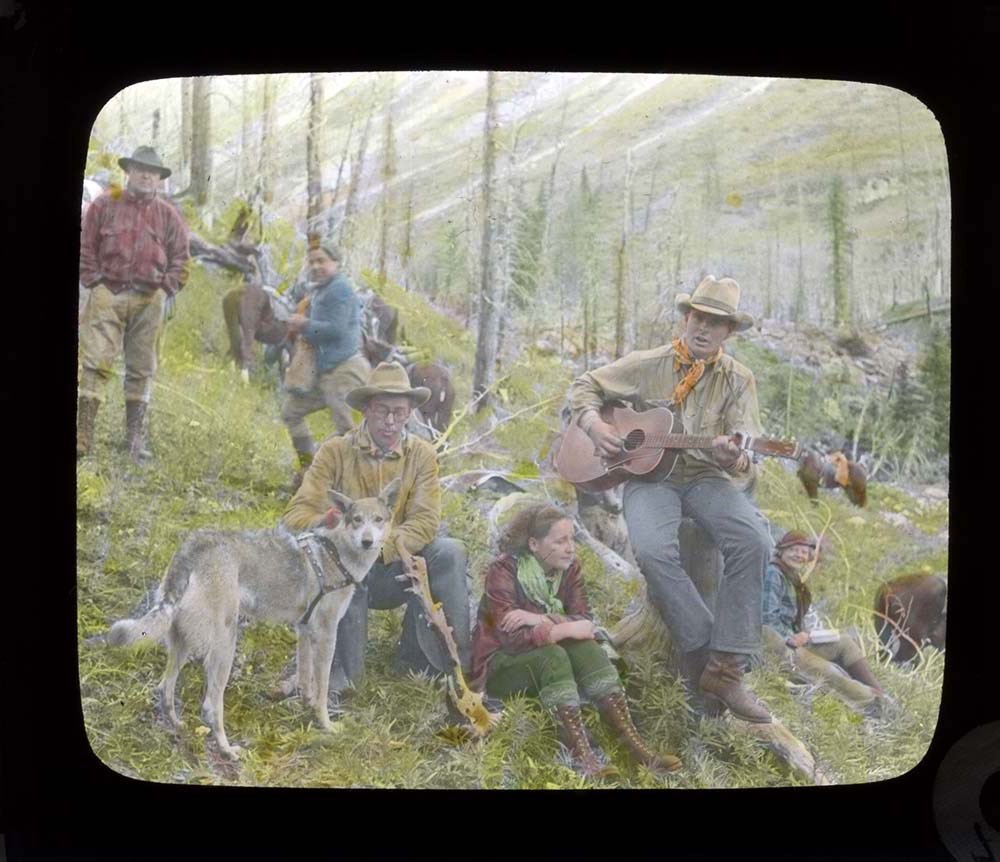
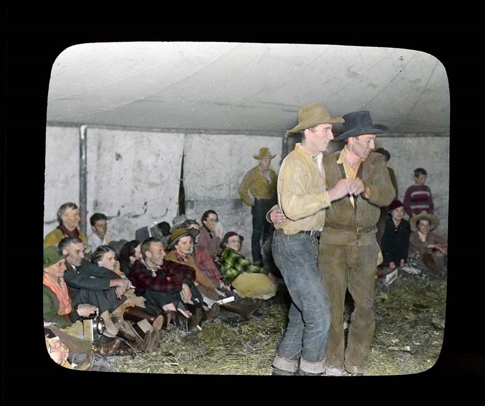
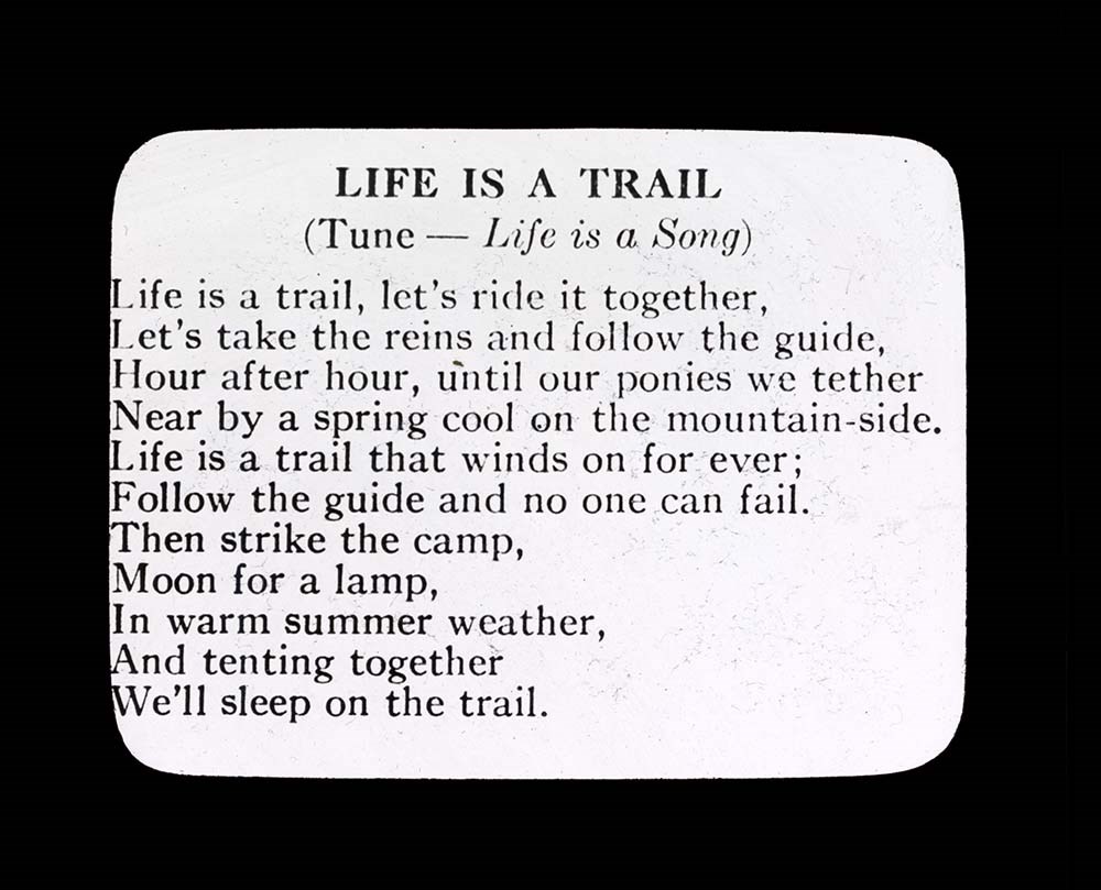
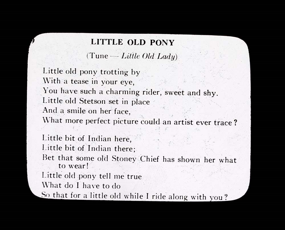
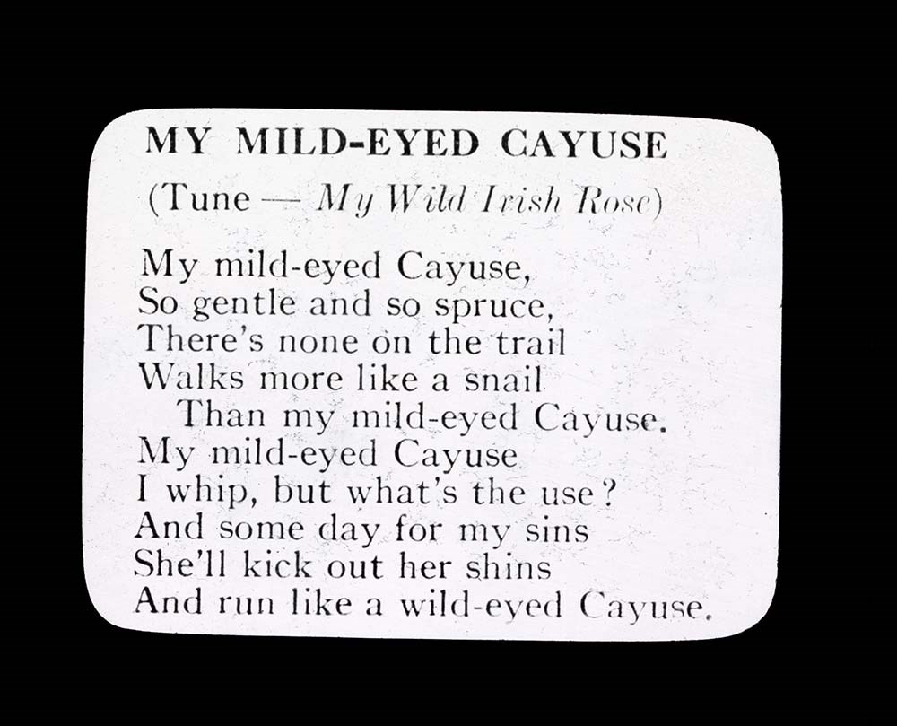
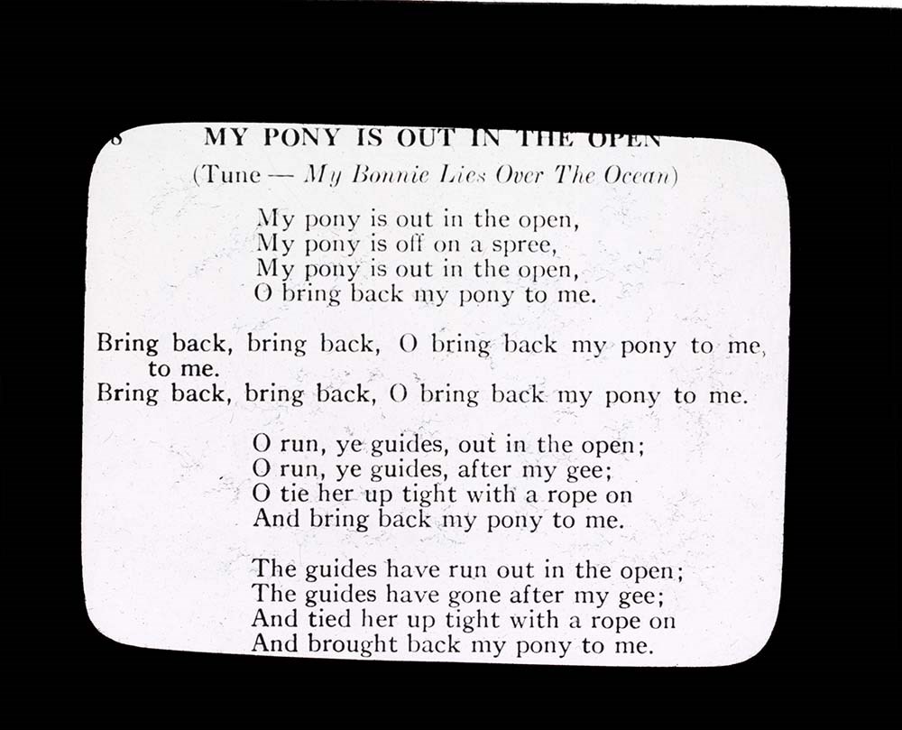
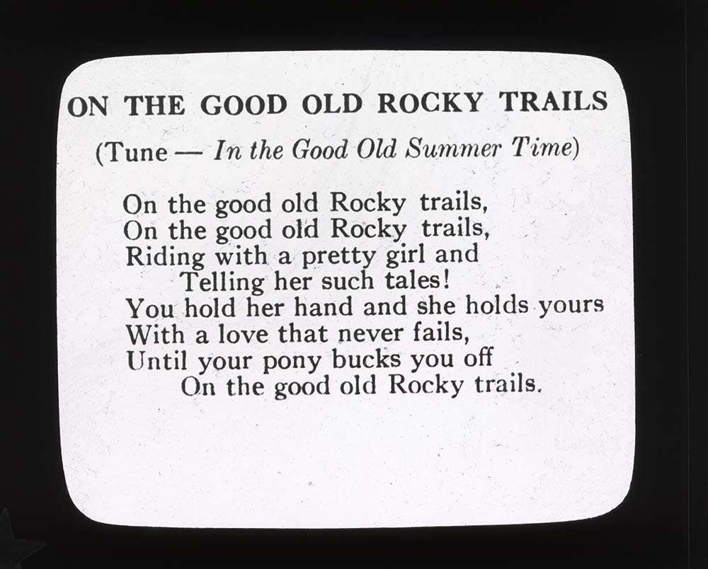
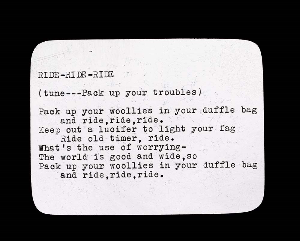
Trail Ride Songs
https://archives.whyte.org/en/permalink/descriptions54699
- Part Of
- Jean A. Hembroff MacDonald fonds
- Scope & Content
- File consists of 7 b&w photograph transparencies (lantern slides). File pertains to trail ride songs that would be sung at the trail ride camp. File includes the following songs: Life is a Trail Little Old Pony My Mild-Eyed Cayuse My Pony is out in the Open On the Good Old Rocky Trails Ride-Ride-Ri…
- Date Range
- ca.1937-ca.1939
- Reference Code
- V797 / II / PS - 61 to 67
- Description Level
- 5 / File
- GMD
- Transparency
- Photograph
- Lantern slide
7 images
- Part Of
- Jean A. Hembroff MacDonald fonds
- Description Level
- 5 / File
- Fonds Number
- M573 / V797 / S60
- Series
- V797 / II : Lantern Slides
- Sous-Fonds
- V797
- Accession Number
- 2019.111
- Reference Code
- V797 / II / PS - 61 to 67
- Date Range
- ca.1937-ca.1939
- Physical Description
- 7 photographs : b&w slides
- Scope & Content
- File consists of 7 b&w photograph transparencies (lantern slides). File pertains to trail ride songs that would be sung at the trail ride camp. File includes the following songs:
- Life is a Trail
- Little Old Pony
- My Mild-Eyed Cayuse
- My Pony is out in the Open
- On the Good Old Rocky Trails
- Ride-Ride-Ride
- When It's Trail Time in the Rockies
- Notes
- Slides were stored with a note stating: "Slides taken by the C.P.R. of Trail Ride, 1936-1937."
- Name Access
- Hembroff MacDonald, Jean
- Subject Access
- Trails
- Trail guides
- Trail Riders of the Canadian Rockies
- Travel
- Skyline Hikers of the Canadian Rockies
- Tourism
- Songs
- Entertainment
- Geographic Access
- Canada
- Canadian Rocky Mountains
- Language
- English
- Title Source
- Title based on contents of file
- Processing Status
- Processed
Images

This material is presented as originally created; it may contain outdated cultural descriptions and
potentially offensive content.
Read more.
Lake O'Hara Trails
https://archives.whyte.org/en/permalink/descriptions54776
- Part Of
- Murray Hay fonds
- Scope & Content
- File consists of 0.5 cm of textual records, 60.5 x 48.5 cm. File pertains to a trail map of the Lake O'Hara area created by Murray Hay. File consists of one published poster depicting a reproduced map of the trails at Lake O'Hara in Yoho National Park (British Columbia).
- Date Range
- ca.1970-ca.2015
- Reference Code
- M570 / III / A / iv / 1
- Description Level
- 5 / File
- GMD
- Map
- Poster
- Published record
- Textual record
- Part Of
- Murray Hay fonds
- Description Level
- 5 / File
- Fonds Number
- M570 / V795
- Series
- M570 / III : Murray Hay Portfolio (published material)
- Sous-Fonds
- M570
- Sub-Series
- M570 / III / A : British Columbia / iv : Lake O'Hara
- Accession Number
- 2019.41
- Reference Code
- M570 / III / A / iv / 1
- Date Range
- ca.1970-ca.2015
- Physical Description
- 0.5 cm of textual material (60.5 x 48.5 cm)
- Scope & Content
- File consists of 0.5 cm of textual records, 60.5 x 48.5 cm. File pertains to a trail map of the Lake O'Hara area created by Murray Hay. File consists of one published poster depicting a reproduced map of the trails at Lake O'Hara in Yoho National Park (British Columbia).
- Notes
- M570 / III / A / iv / 1 is oversize.
- Name Access
- Hay, Murray
- Subject Access
- Trails
- Hiking
- Cartography
- Advertising
- Artist
- Sports and recreation
- Travel
- Tourism
- Tourist information
- Geographic Access
- Lake O'Hara
- British Columbia
- Canada
- Canadian Rocky Mountains
- Yoho National Park
- Language
- English
- Title Source
- Title based on contents of file
- Processing Status
- Processed
This material is presented as originally created; it may contain outdated cultural descriptions and
potentially offensive content.
Read more.
Sunshine Ski Area
https://archives.whyte.org/en/permalink/descriptions54780
- Part Of
- Murray Hay fonds
- Scope & Content
- File consists of 1.5 cm of textual records, 58 x 72.5 cm and 21.5 x 27.5 cm. File pertains to ski trail maps of Sunshine Ski Area created by Murray Hay. File includes two published reproductions of original trail maps in poster format made by Hay for the Husky World Downhill and Giant Slalom on Mar…
- Date Range
- ca.1985-1986
- 1986
- Reference Code
- M570 / III / B / i / 1-2
- Description Level
- 5 / File
- GMD
- Map
- Poster
- Textual record
- Published record
- Part Of
- Murray Hay fonds
- Description Level
- 5 / File
- Fonds Number
- M570 / V795
- Series
- M570 / III : Murray Hay Portfolio (published material)
- Sous-Fonds
- M570
- Sub-Series
- M570 / III / B : Alberta / i : Sunshine
- Accession Number
- 2019.41
- Reference Code
- M570 / III / B / i / 1-2
- Date Range
- ca.1985-1986
- 1986
- Physical Description
- 1.5 cm of textual records (58 x 72.5 cm and 21.5 x 27.5 cm)
- Scope & Content
- File consists of 1.5 cm of textual records, 58 x 72.5 cm and 21.5 x 27.5 cm. File pertains to ski trail maps of Sunshine Ski Area created by Murray Hay. File includes two published reproductions of original trail maps in poster format made by Hay for the Husky World Downhill and Giant Slalom on March 8-9, 1986.
- Notes
- M570 / III / B / i / 2 is oversize.
- Name Access
- Hay, Murray
- Subject Access
- Skiing
- Ski Maps
- Ski area
- Tourism
- Cartography
- Map
- Winter
- Winter sports
- Travel
- Sunshine Village
- Sunshine Ski Resort
- Sunshine area
- Sports and recreation
- Artist
- Advertising
- Geographic Access
- Banff National Park
- Alberta
- Canada
- Canadian Rocky Mountains
- Language
- English
- Related Material
- V795 / II / B / vi / 1-3
- Title Source
- Title based on contents of file
- Processing Status
- Processed
This material is presented as originally created; it may contain outdated cultural descriptions and
potentially offensive content.
Read more.
- Part Of
- Murray Hay fonds
- Scope & Content
- File consists of 1.5 cm of textual records, 53 x 80.5 cm and 10 x 23.5 cm. File pertains to ski trail maps of Lake Louise ski area created by Murray Hay. File includes two published reproductions of three original trail maps in a fold-out brochure (1992/1993) and in poster format. The three maps de…
- Date Range
- ca.1980 - ca. 1995
- 1992-1993
- Reference Code
- M570 / III / B / ii / 1-2
- Description Level
- 5 / File
- GMD
- Textual record
- Published record
- Map
- Poster
- Part Of
- Murray Hay fonds
- Description Level
- 5 / File
- Fonds Number
- M570 / V795
- Series
- M570 / III : Murray Hay portfolio (published material)
- Sous-Fonds
- M570
- Sub-Series
- M570 / III / B : Alberta / ii : Lake Louise
- Accession Number
- 2019.41
- Reference Code
- M570 / III / B / ii / 1-2
- Date Range
- ca.1980 - ca. 1995
- 1992-1993
- Physical Description
- 1.5 cm of textual records (53 x 80.5 cm and 10 x 23.5 cm)
- Scope & Content
- File consists of 1.5 cm of textual records, 53 x 80.5 cm and 10 x 23.5 cm. File pertains to ski trail maps of Lake Louise ski area created by Murray Hay. File includes two published reproductions of three original trail maps in a fold-out brochure (1992/1993) and in poster format. The three maps depict South Face, Back Bowls, and Larch Area.
- Name Access
- Hay, Murray
- Subject Access
- Ski area
- Ski Maps
- Skiing
- Tourism
- Cartography
- Map
- Winter
- Winter sports
- Sports and recreation
- Travel
- Lake Louise Ski Area
- Lake Louise
- Artist
- Advertising
- Geographic Access
- Lake Louise
- Alberta
- Canada
- Canadian Rocky Mountains
- Language
- English
- Related Material
- V795 / II / B / ii / 1
- Title Source
- Title based on contents of file
- Processing Status
- Processed
This material is presented as originally created; it may contain outdated cultural descriptions and
potentially offensive content.
Read more.
A Native Heritage
https://archives.whyte.org/en/permalink/descriptions54799
- Part Of
- Luxton family fonds
- Scope & Content
- File consists of one large booklet/portfolio containing biographical information, illustrations, and 10 copies of painted colour portraits all pertaining to Indigenous chiefs. Individuals depicted are: Crowfoot [Southern Blackfoot], Old Sun [Northern Blackfoot], Red Crow [Southern Blood tribe], Bul…
- Date Range
- [1970-1980]
- Reference Code
- LUX / II / F1 / 55
- Description Level
- 5 / File
- GMD
- Textual record
- Published record
- Drawing
- Painting
- Part Of
- Luxton family fonds
- Description Level
- 5 / File
- Fonds Number
- LUX
- Series
- LUX / II / F : Collected material
- Sous-Fonds
- LUX / II : Eleanor Luxton sous-fonds
- Sub-Series
- LUX / II / F1 : Textual
- Accession Number
- LUX
- Reference Code
- LUX / II / F1 / 55
- Responsibility
- Art produced by Mort Graham
- Date Range
- [1970-1980]
- Physical Description
- 0.5 cm of textual records (1 volume ; 38 x 48 cm)
- Scope & Content
- File consists of one large booklet/portfolio containing biographical information, illustrations, and 10 copies of painted colour portraits all pertaining to Indigenous chiefs. Individuals depicted are: Crowfoot [Southern Blackfoot], Old Sun [Northern Blackfoot], Red Crow [Southern Blood tribe], Bull Head [Sarcee], Eagle Tail [North Piegans], Poundmaker [Cree], Medicine Calf [Southern Blood tribe], Big Bear [Cree], Big Plume [Sarcee], and Pakan [Wood Cree]. Collection also includes historical information pertaining to Indigenous history in Western Canada written by Dr. James G. MacGregor, and a map depicting Indigenous treaty boundaries in and around the Rocky Mountains.
- Notes
- Date range provided is estimate by Processing Archivist
- Name Access
- Graham, Mort
- MacGregor, James
- Subject Access
- Indigenous Peoples
- History
- Art
- Artist
- Portrait
- Biography
- Geography
- Government
- Geographic Access
- Canada
- United States of America
- Canadian Rocky Mountains
- Rocky Mountains
- Reproduction Restrictions
- Copyright restrictions may apply
- Language
- English
- Category
- Arts
- First nations
- Title Source
- Title based on contents of file
- Processing Status
- Processed
This material is presented as originally created; it may contain outdated cultural descriptions and
potentially offensive content.
Read more.