Narrow Results By
- Ben Gadd fonds 3
- Nicholas Morant fonds 3
- Luxton family fonds 2
- Arnold Wexler fonds 1
- Arthur Oliver Wheeler fonds 1
- Bert Riggall fonds 1
- Brewster Transport Company Ltd. fonds 1
- Bruno Engler fonds 1
- Burks family fonds 1
- Ernest C. W. Lamarque fonds 1
- Fred Brewster fonds 1
- George K. K. (Tommy) Link fonds 1
- Catharine Robb Whyte, O. C. (1906 – 1979, Canadian) 43
- Peter Whyte (1905 – 1966, Canadian) 5
- Gennadiy Ivanov 4
- Gadd, Ben 2
- Schaffer, Mary 2
- Adams, Molly 1
- Alberta/British Columbia Boundary Survey 1
- Brewster Transport Company Ltd. 1
- Brewster, Dell 1
- Brewster, Fern 1
- Brewster, Fred 1
- Brewster, Jack Walker 1
- Artist
- Gennadiy Ivanov
- Date
- ca. 2022 – 2022
- Medium
- pastel on paper
- Catalogue Number
- IvG.03.03
- Description
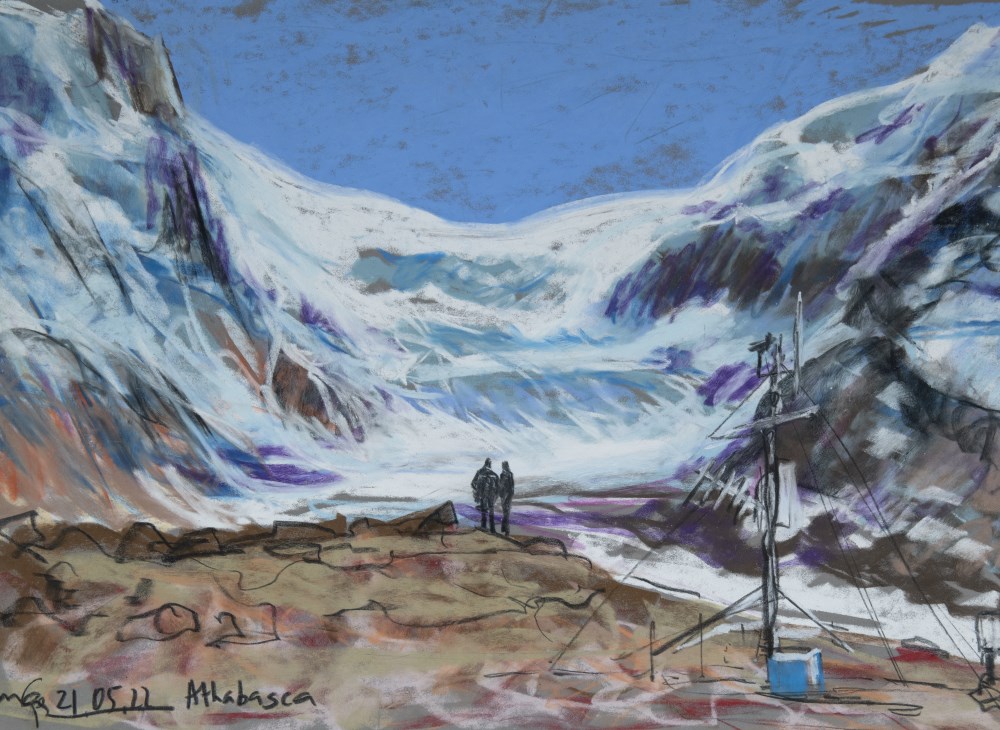
- Landscape painting of glacial area. Background has a blue sky that is filled with tall glacial formations. Right at the centre of the middle ground are silhouettes of two people rendered in black. Off to the the right side of the foreground is a weather station. The colour palette is made up of blu…
1 image
- Artist
- Gennadiy Ivanov
- Title
- Athabasca
- Date
- ca. 2022 – 2022
- Medium
- pastel on paper
- Dimensions
- 34.0 x 50.0 cm
- Description
- Landscape painting of glacial area. Background has a blue sky that is filled with tall glacial formations. Right at the centre of the middle ground are silhouettes of two people rendered in black. Off to the the right side of the foreground is a weather station. The colour palette is made up of blue, purples, orange, black, brown, green, and white.
- Credit
- Gift of Gennadiy Ivanov, Norwich, Norfolk , UK, 2023
- Catalogue Number
- IvG.03.03
Images
This material is presented as originally created; it may contain outdated cultural descriptions and
potentially offensive content.
Read more.
Athabasca Glacier Station 1
https://archives.whyte.org/en/permalink/artifactivg.03.02
- Artist
- Gennadiy Ivanov
- Date
- ca. 2019 – 2019
- Medium
- pastel on paper
- Catalogue Number
- IvG.03.02
- Description
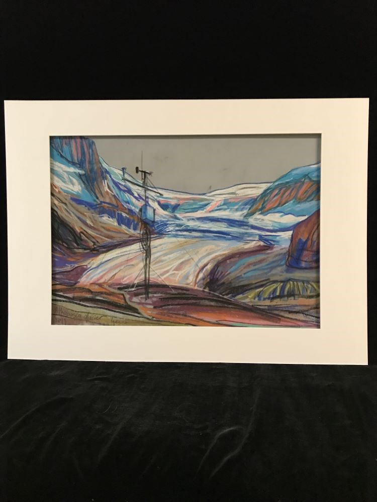
- Landscape pastel drawing of a glacier area, colour palette made up of purple,orange, yellows, blues and black. In the background there are glaciers, hills,or mountains. Middle ground is filled with vertical and horizontal lines that represent the pattern of glaciers. In the foreground, off to the l…
1 image
- Artist
- Gennadiy Ivanov
- Title
- Athabasca Glacier Station 1
- Date
- ca. 2019 – 2019
- Medium
- pastel on paper
- Dimensions
- 49.0 x 69.0 x 49.0 cm
- Description
- Landscape pastel drawing of a glacier area, colour palette made up of purple,orange, yellows, blues and black. In the background there are glaciers, hills,or mountains. Middle ground is filled with vertical and horizontal lines that represent the pattern of glaciers. In the foreground, off to the left hand side is a weather station made up of black and blue.
- Credit
- Gift of Gennadiy Ivanov, Norwich, Norfolk , UK, 2023
- Catalogue Number
- IvG.03.02
Images
This material is presented as originally created; it may contain outdated cultural descriptions and
potentially offensive content.
Read more.
Athabasca Glacier Station 2
https://archives.whyte.org/en/permalink/artifactivg.03.01
- Artist
- Gennadiy Ivanov
- Date
- ca. 2019 – 2019
- Medium
- pastel on paper
- Catalogue Number
- IvG.03.01
- Description
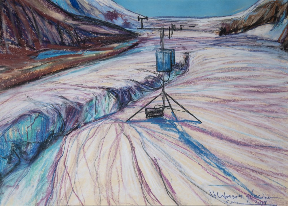
- Landscape pastel drawing with a colour palette made up of purples, blues, and soft peach. in the background there are glaciers or mountains. In the middle ground, just slightly off to the right, there is a weather station composed of black and blue pastel. in the foreground are vertical lines of pu…
1 image
- Artist
- Gennadiy Ivanov
- Title
- Athabasca Glacier Station 2
- Date
- ca. 2019 – 2019
- Medium
- pastel on paper
- Dimensions
- 50.0 x 65.0 x 50.0 cm
- Description
- Landscape pastel drawing with a colour palette made up of purples, blues, and soft peach. in the background there are glaciers or mountains. In the middle ground, just slightly off to the right, there is a weather station composed of black and blue pastel. in the foreground are vertical lines of purple, white, and blue, that represent patterns of the glaciers.
- Credit
- Gift of Gennadiy Ivanov, Norwich, Norfolk , UK, 2023
- Catalogue Number
- IvG.03.01
Images
This material is presented as originally created; it may contain outdated cultural descriptions and
potentially offensive content.
Read more.
Travel guides and maps
https://archives.whyte.org/en/permalink/descriptions56361
- Part Of
- Ben Gadd fonds
- Scope & Content
- Sub-series consists of travel brochures and maps which were collected and used by Ben Gadd. Sub-series contains five sub-sub series: M590 / I / A / i : Travel guides and pocket maps M590 / I / A / ii : Topographical maps M590 / I / A / iii : Geological maps M590 / I / A / iv : Highway maps M590 / …
- Date Range
- [ca.1920-2010]
- Reference Code
- M590 / I / A
- Description Level
- 4 / Sub-series
- GMD
- Map
- Textual record
- Part Of
- Ben Gadd fonds
- Description Level
- 4 / Sub-series
- Fonds Number
- M590
- V810
- S61
- Series
- M590 / I : Personal records
- Sous-Fonds
- M590
- Sub-Series
- M590 / I / A : Travel guides and maps
- Accession Number
- 2021.20
- Reference Code
- M590 / I / A
- GMD
- Map
- Textual record
- Date Range
- [ca.1920-2010]
- Physical Description
- ca. 274 maps -- ca. 61 travel guides, brochures
- Scope & Content
- Sub-series consists of travel brochures and maps which were collected and used by Ben Gadd. Sub-series contains five sub-sub series: M590 / I / A / i : Travel guides and pocket maps M590 / I / A / ii : Topographical maps M590 / I / A / iii : Geological maps M590 / I / A / iv : Highway maps M590 / I / A / v : Index maps, other
- Notes
- Some materials in sub-series are annotated with notes by Ben Gadd
- Name Access
- Gadd, Ben
- Subject Access
- Geography
- Geology
- Environment
- Map
- Tourism
- Tourist information
- Travel
- Trails
- Roads
- Transportation
- Natural history
- National parks and reserves
- Provincial parks and reserves
- Government
- Sports
- Recreation
- Hiking
- Geographic Access
- Canada
- Alberta
- British Columbia
- Banff National Park
- Jasper National Park
- Kootenay National Park
- Yoho National Park
- Waterton Lakes National Park
- Columbia Icefields
- United States of America
- Colorado
- Montana
- Yellowstone National Park
- Access Restrictions
- Restrictions may apply - some materials are fragile
- Reproduction Restrictions
- Restrictions may apply
- Language
- English
- Conservation
- Some fragile/torn materials stored in mylar
- Category
- Environment
- Exploration, discovery and travel
- Government
- Sports, recreation and leisure
- Transportation
- Tourism
- Title Source
- Title based on contents of sub-series
- Processing Status
- Processed
This material is presented as originally created; it may contain outdated cultural descriptions and
potentially offensive content.
Read more.
Operation Bow-Athabasca exhibit
https://archives.whyte.org/en/permalink/descriptions56253
- Part Of
- Ben Gadd fonds
- Scope & Content
- File consists of correspondence, maps and other documents pertaining to the Operation Bow-Athabasca exhibit, which was displayed at the Canmore Museum and Geoscience Centre in 2012. File includes a programme for the opening of the exhibition; geological maps and other research materials; a quote fo…
- Date Range
- 1973
- 2010-2012
- Reference Code
- M590 / III / D / 117
- Description Level
- 5 / File
- GMD
- Textual record
- Published record
- Map
- Part Of
- Ben Gadd fonds
- Description Level
- 5 / File
- Fonds Number
- M590
- V810
- S61
- Series
- M590 / III : Professional records
- Sous-Fonds
- M590
- Sub-Series
- M590 / III / D : Other contracts and projects
- Accession Number
- 2021.20
- Reference Code
- M590 / III / D / 117
- Date Range
- 1973
- 2010-2012
- Physical Description
- 1.5 cm of textual records -- 4 maps
- Scope & Content
- File consists of correspondence, maps and other documents pertaining to the Operation Bow-Athabasca exhibit, which was displayed at the Canmore Museum and Geoscience Centre in 2012. File includes a programme for the opening of the exhibition; geological maps and other research materials; a quote for the production of display signs for the exhibit; Ben Gadd's personal notes pertaining to the exhibit; and other related materials.
- Name Access
- Gadd, Ben
- Subject Access
- Natural history
- Geology
- Environment
- Research
- Public events
- Community events
- Publication
- Museums
- Geographic Access
- Canada
- Alberta
- Canmore
- Reproduction Restrictions
- Restrictions may apply
- Language
- English
- Category
- Environment
- Title Source
- Title based on contents of file
- Processing Status
- Processed
This material is presented as originally created; it may contain outdated cultural descriptions and
potentially offensive content.
Read more.
Travel guides - United States, Italy
https://archives.whyte.org/en/permalink/descriptions55928
- Part Of
- Ben Gadd fonds
- Scope & Content
- File consists of travel guides collected by Ben Gadd pertaining to Olympic National Park and other destinations in the United States and Italy.
- Date Range
- [ca.1990-2010]
- Reference Code
- M590 / I / A / i / 14
- Description Level
- 5 / File
- GMD
- Published record
- Textual record
- Map
- Part Of
- Ben Gadd fonds
- Description Level
- 5 / File
- Fonds Number
- M590
- V810
- S61
- Series
- M590 / I : Personal records
- Sous-Fonds
- M590
- Sub-Series
- M590 / I / A : Travel guides and maps
- Accession Number
- 2021.20
- Reference Code
- M590 / I / A / i / 14
- Date Range
- [ca.1990-2010]
- Physical Description
- 2 cm of textual records
- Scope & Content
- File consists of travel guides collected by Ben Gadd pertaining to Olympic National Park and other destinations in the United States and Italy.
- Subject Access
- Geography
- Travel
- Tourism
- Tourist information
- National parks and reserves
- Geographic Access
- United States of America
- Washington
- Hawaii
- Italy
- Reproduction Restrictions
- Copyright restrictions may apply
- Language
- English
- Category
- Exploration, discovery and travel
- Title Source
- Title based on contents of file
- Processing Status
- Processed
This material is presented as originally created; it may contain outdated cultural descriptions and
potentially offensive content.
Read more.
Rocky Mountains Park topographical map
https://archives.whyte.org/en/permalink/descriptions55707
- Part Of
- Luxton family fonds
- Scope & Content
- File consists of one printed map on canvas depicting Rocky Mountains Park and surrounding areas, ca.1910-1930. Map is annotated with red hand-coloured markers and small notes written in black ink.
- Date Range
- [ca.1910-1930]
- Reference Code
- LUX / III / D / 38 (oversize)
- Description Level
- 5 / File
- GMD
- Map
- Part Of
- Luxton family fonds
- Description Level
- 5 / File
- Fonds Number
- LUX
- Series
- LUX / III / D : Other material
- Sous-Fonds
- LUX / III : Luxton family sous-fonds
- Accession Number
- LUX
- Reference Code
- LUX / III / D / 38 (oversize)
- GMD
- Map
- Date Range
- [ca.1910-1930]
- Physical Description
- 1 topographical map : hand col., annotations, on canvas ; 150 x 100 cm
- History / Biographical
- Rocky Mountains Park was renamed Banff National Park on May 30, 1930 as part of the National Parks Act passed by the Government of Canada.
- Scope & Content
- File consists of one printed map on canvas depicting Rocky Mountains Park and surrounding areas, ca.1910-1930. Map is annotated with red hand-coloured markers and small notes written in black ink.
- Notes
- Context of map mostly unknown. Missing title, date and other identifying information.
- Subject Access
- Map
- Geography
- Landscapes
- Parks
- Geographic Access
- Canada
- Alberta
- Canadian Rocky Mountains
- Access Restrictions
- Map is difficult to handle due to size and condition. Assistance from archival staff required for physical access
- Language
- English
- Conservation
- Use nitrile gloves while handling map
- Biographical Source Notes
- http://parkscanadahistory.com/publications/national-parks-act-1930.htm
- Title Source
- Title based on contents of file
- Processing Status
- Processed
This material is presented as originally created; it may contain outdated cultural descriptions and
potentially offensive content.
Read more.
Margaret Oliver fonds
https://archives.whyte.org/en/permalink/descriptions55186
- Part Of
- Margaret Oliver fonds
- Scope & Content
- Fonds consists of transparency slides, maps, handwritten notes and club records, song books, and scrapbooks pertaining to Margaret Ruth Oliver and the Tuesday Hikers club.
- Date Range
- 1971-2010
- Reference Code
- M569 / V793
- Description Level
- 1 / Fonds
- GMD
- Textual record
- Photograph
- Transparency
- Published record
- Private record
- Scrapbook
- Map
- Organization record
- Part Of
- Margaret Oliver fonds
- Description Level
- 1 / Fonds
- Fonds Number
- M569 / V793
- Sous-Fonds
- M569
- V793
- Accession Number
- 2017.8656
- Reference Code
- M569 / V793
- GMD
- Textual record
- Photograph
- Transparency
- Published record
- Private record
- Scrapbook
- Map
- Organization record
- Date Range
- 1971-2010
- Physical Description
- 28 photographs : col. slides -- 1.5 m of textual records (3 binders -- 1 record book -- 10 song books -- maps, annotated -- 11 scrapbooks)
- History / Biographical
- Margaret Ruth Oliver was born on December 19, 1927 to parents Edgar and Gladys (Brazier) Hammett in Winnipeg, Manitoba. Margaret's siblings include Dorothy (1922), Muriel "Miv" (1923), John (1929), and Jean (1933). Margaret graduated from United College (Winnipeg) in 1949 with a B.Sc. degree, and worked as an Assistant Librarian at the University of Manitoba afterwards. Margaret later enrolled in a Laboratory Technician program at the University of Manitoba Medical College. Margaret married Thomas Albert Oliver, a fellow University of Manitoba alumnus, on September 25, 1954. The couple moved to Calgary for work (Thomas taught at the University of Calgary, and Margaret worked for a geophysical company). Margaret travelled extensively following the death of her husband in 1997, visiting places such as Nepal, Cambodia, Russia, Egypt and Greenland. In 1971, Margaret formed a hiking group within the University Faculty Women's Club (F.W.C.) through the University of Calgary. In 1976, this group became a private club called the Tuesday Hikers, which no longer held any affiliation to the F.W.C. Trips included weekly hikes and/or ski trips, as well as longer backpacking excursions.The club is still active as of 2022.
- Scope & Content
- Fonds consists of transparency slides, maps, handwritten notes and club records, song books, and scrapbooks pertaining to Margaret Ruth Oliver and the Tuesday Hikers club.
- Notes
- Materials are unprocessed and stored in three boxes: Box 1: 1 envelope "T. Hikers' Slides" - 28 film transparencies and printed notes; various maps with handwritten notes Box 2: 1 record book "T.H. Record Book" - handwritten lists and statistics of trips, attendance, miles; 2 binders with handwritten notes, titled "National Parks - Banff and Assiniboine" and "Nat'l Parks - Glacier + Jasper" Box 3: 1 binder titled "Tues. Hikers- Past Members and Guests"; 10 song books; trail, park and road maps; 11 scrapbooks, 1971-2010
- Name Access
- Oliver, Margaret
- Subject Access
- Hiking
- Travel
- Recreation
- Club
- Map
- Trails
- Music
- Entertainment
- Geography
- Geographic Access
- Canada
- Alberta
- Banff National Park
- Jasper National Park
- Assiniboine
- British Columbia
- Glacier National Park
- Language
- English
- Biographical Source Notes
- https://biblio.uottawa.ca/en/node/16056
- Title Source
- Title based on content in fonds
- Processing Status
- Unprocessed
This material is presented as originally created; it may contain outdated cultural descriptions and
potentially offensive content.
Read more.
Maps of Banff and Western Canada
https://archives.whyte.org/en/permalink/descriptions54772
- Part Of
- Luxton family fonds
- Scope & Content
- File consists of 9 printed maps, b&w and col. [including zoning and topographical maps] depicting the Town of Banff and Banff National Park, the Rocky Mountains Forest Reserve, the Moose Mountain region, Medicine Hat, and the province of Alberta. File includes Trail Riders' Map of the Canadian Rock…
- Date Range
- 1912
- 1914
- 1924
- 1926
- 1932
- 1957
- [1970-1980]
- Reference Code
- LUX / II / C5 / 25
- Description Level
- 5 / File
- GMD
- Textual record
- Published record
- Map
- Part Of
- Luxton family fonds
- Description Level
- 5 / File
- Fonds Number
- LUX
- Series
- LUX / II / C : Personal
- Sous-Fonds
- LUX / II : Eleanor Luxton sous-fonds
- Sub-Series
- LUX / II / C5 : Other
- Accession Number
- LUX
- Reference Code
- LUX / II / C5 / 25
- Date Range
- 1912
- 1914
- 1924
- 1926
- 1932
- 1957
- [1970-1980]
- Physical Description
- 9 maps : b&w and col. ; 168 x 71 cm or smaller
- Scope & Content
- File consists of 9 printed maps, b&w and col. [including zoning and topographical maps] depicting the Town of Banff and Banff National Park, the Rocky Mountains Forest Reserve, the Moose Mountain region, Medicine Hat, and the province of Alberta. File includes Trail Riders' Map of the Canadian Rockies which has smaller maps of Waterton Lakes, Glacier, Revelstoke, and other national parks printed on the back. Map of Medicine Hat includes annotated storage envelope with dimensions written on the front.
- Subject Access
- Cartography
- Geography
- Land use
- Government
- Travel
- National parks and reserves
- Geographic Access
- Canada
- Alberta
- Banff
- Banff National Park
- Medicine Hat
- Rocky Mountains
- Glacier National Park
- Revelstoke
- Waterton Lakes National Park
- Reproduction Restrictions
- Restrictions may apply
- Language
- English
- Title Source
- Title based on contents of file
- Processing Status
- Processed
This material is presented as originally created; it may contain outdated cultural descriptions and
potentially offensive content.
Read more.
Map of central part of Jasper from surveys by M.P. Bridgland
https://archives.whyte.org/en/permalink/catalogue24294
- Medium
- Library - Maps and blueprints (unannotated; published)
- Map
- Published Date
- 1917
- Publisher
- Department of the Interior
- Call Number
- C2-2.1
- Responsibility
- from surveys by M. P. Bridgland
- Publisher
- Department of the Interior
- Published Date
- 1917
- Physical Description
- 6 sheets : col
- Scale
- Scale: 1.014 in. = 1 mile
- Relief: Contour interval: 100 ft.
- Subjects
- Jasper National Park
- Accession Number
- 512
- 718
- Call Number
- C2-2.1
- Collection
- Archives Library
This material is presented as originally created; it may contain outdated cultural descriptions and
potentially offensive content.
Read more.
Preliminary map of the Canadian Rocky Mtns between Jarvis Pass and Yellowhead Pass showing the route followed by Mary Jobe in August 1914|Mary Jobe's trip through the northern Rockies
https://archives.whyte.org/en/permalink/catalogue24304
- Medium
- Library - Maps and blueprints (unannotated; published)
- Map
- Published Date
- 1915
- Publisher
- Bulletin of the American Geographic Society, vol. XLV11, 7
- Call Number
- C6-3.9(a)
- C6-3.9(b)
- Publisher
- Bulletin of the American Geographic Society, vol. XLV11, 7
- Published Date
- 1915
- Scale
- 1:300,000
- Subjects
- Rocky Mountains
- Canadian
- Notes
- xerox copy of M.67, M2.1
- Accession Number
- 6500
- Call Number
- C6-3.9(a)
- C6-3.9(b)
- Collection
- Archives Library
This material is presented as originally created; it may contain outdated cultural descriptions and
potentially offensive content.
Read more.
Map of Pelly, Ross and Gravel Rivers
https://archives.whyte.org/en/permalink/catalogue24369
- Medium
- Library - Maps and blueprints (unannotated; published)
- Map
- Published Date
- 1910
- Publisher
- Dept. of Mines and Geological Survey
- Call Number
- C8-1.3
- Publisher
- Dept. of Mines and Geological Survey
- Published Date
- 1910
- Scale
- 8 miles to 1 inch
- Subjects
- Yukon and North West Territories
- Notes
- Sources of info: G.M. Dawson, R.G. McConn., J. Keele, W. Ogilvie
- Accession Number
- 576
- Call Number
- C8-1.3
- Collection
- Archives Library
This material is presented as originally created; it may contain outdated cultural descriptions and
potentially offensive content.
Read more.
Alberta : Athabaska sheet
https://archives.whyte.org/en/permalink/catalogue24415
- Medium
- Library - Maps and blueprints (unannotated; published)
- Map
- Published Date
- 1914
- Publisher
- Ottawa: Office of the Surveyor General
- Edition
- 2d ed.
- Call Number
- C9-2.4
- Edition
- 2d ed.
- Publisher
- Ottawa: Office of the Surveyor General
- Published Date
- 1914
- Physical Description
- 1 map
- Scale
- Scale: 1:190,080
- Subjects
- Athabaska River
- Notes
- Sectional map
- Accession Number
- 5576
- 4008
- Call Number
- C9-2.4
- Collection
- Archives Library
This material is presented as originally created; it may contain outdated cultural descriptions and
potentially offensive content.
Read more.
[Alberta] South-central portion
https://archives.whyte.org/en/permalink/catalogue24416
- Medium
- Library - Maps and blueprints (unannotated; published)
- Map
- Published Date
- 1910
- Publisher
- Dept. of the Interior, Ottawa
- Call Number
- C9-3.1
- Publisher
- Dept. of the Interior, Ottawa
- Published Date
- 1910
- Scale
- Bench marks
- Subjects
- Alberta
- Notes
- 1 duplicate in map room - Accn. 400
- Accession Number
- 400
- Call Number
- C9-3.1
- Collection
- Archives Library
This material is presented as originally created; it may contain outdated cultural descriptions and
potentially offensive content.
Read more.
[Bow River Basin above Calgary]
https://archives.whyte.org/en/permalink/catalogue24417
- Medium
- Library - Maps and blueprints (unannotated; published)
- Map
- Published Date
- 1912
- Publisher
- Dept. of the Interior Water Power Branch
- Call Number
- C9-3.2
- Publisher
- Dept. of the Interior Water Power Branch
- Published Date
- 1912
- Scale
- Scale: 4 miles: 1 inch
- Relief: Contour interval 500 ft.
- Subjects
- Bow River Basin
- Notes
- 2 duplicates in map room - Accn. 400
- Accession Number
- 400
- Call Number
- C9-3.2
- Collection
- Archives Library
This material is presented as originally created; it may contain outdated cultural descriptions and
potentially offensive content.
Read more.
[Calgary sheet] Sectional map
https://archives.whyte.org/en/permalink/catalogue24418
- Medium
- Library - Maps and blueprints (unannotated; published)
- Map
- Published Date
- 1912
- Publisher
- Surveyor Generals' Office, Ottawa
- Call Number
- C9-3.3
- Publisher
- Surveyor Generals' Office, Ottawa
- Published Date
- 1912
- Physical Description
- 1 map : black and white
- Scale
- Scale: 3 miles: 1 inch
- Relief: Bench marks
- Subjects
- Calgary
- Call Number
- C9-3.3
- Collection
- Archives Library
This material is presented as originally created; it may contain outdated cultural descriptions and
potentially offensive content.
Read more.
[Northern Alberta]
https://archives.whyte.org/en/permalink/catalogue24420
- Medium
- Library - Maps and blueprints (unannotated; published)
- Map
- Published Date
- 1917
- Publisher
- Dept. of the Interior
- Call Number
- C9-4.1
- Publisher
- Dept. of the Interior
- Published Date
- 1917
- Physical Description
- 1 map : col
- Scale
- Scale: 12 1/2 miles: 1 inch
- Subjects
- Northern Alberta
- Accession Number
- 478
- Call Number
- C9-4.1
- Collection
- Archives Library
This material is presented as originally created; it may contain outdated cultural descriptions and
potentially offensive content.
Read more.
Sectional map
https://archives.whyte.org/en/permalink/catalogue24464
- Medium
- Library - Maps and blueprints (unannotated; published)
- Map
- Published Date
- 1910
- Publisher
- Dept. of the Interior, Ottawa
- Call Number
- C9-6.4
- Publisher
- Dept. of the Interior, Ottawa
- Published Date
- 1910
- Scale
- 6 miles: 1 inch
- Subjects
- Calgary Sheet
- Accession Number
- 400
- Call Number
- C9-6.4
- Collection
- Archives Library
This material is presented as originally created; it may contain outdated cultural descriptions and
potentially offensive content.
Read more.
Sectional map
https://archives.whyte.org/en/permalink/catalogue24465
- Medium
- Library - Maps and blueprints (unannotated; published)
- Map
- Published Date
- 1910
- Publisher
- Department of the Interior, Ottawa
- Call Number
- C9-6.6
- Publisher
- Department of the Interior, Ottawa
- Published Date
- 1910
- Scale
- 6 miles: 1 inch
- Subjects
- Rocky Mountain House Sheet
- Accession Number
- 400
- Call Number
- C9-6.6
- Collection
- Archives Library
This material is presented as originally created; it may contain outdated cultural descriptions and
potentially offensive content.
Read more.
(Castle Mtn. Station)
https://archives.whyte.org/en/permalink/catalogue24476
- Medium
- Library - Maps and blueprints (unannotated; published)
- Map
- Published Date
- September 6th, 1910
- Publisher
- Department of the Interior
- Call Number
- C9-7.26
- Publisher
- Department of the Interior
- Published Date
- September 6th, 1910
- Physical Description
- 1 map : black and white
- Scale
- 40 chains: 1"
- Accession Number
- SG7500
- Call Number
- C9-7.26
- Collection
- Archives Library
This material is presented as originally created; it may contain outdated cultural descriptions and
potentially offensive content.
Read more.