Narrow Results By
- Murray Hay fonds 18
- Ben Gadd fonds 6
- Nicholas Morant fonds 6
- Trail Riders of the Canadian Rockies fonds 6
- Kidney family fonds 3
- Luxton family fonds 3
- Dorothy Cranstone fonds 2
- Dorothy Wardle fonds 2
- Dorothy Whyte fonds 2
- George K. K. (Tommy) Link fonds 2
- Lawrence Grassi fonds 2
- Alpine Club of Canada fonds 1
Jon Whelan fonds
https://archives.whyte.org/en/permalink/descriptions57454
- Part Of
- Jon Whelan fonds
- Scope & Content
- Fonds consists of research materials, publications, ephemera, and other materials collected by Jon Whelan. Fonds includes three Canadian Pacific bell boy log books, 1970-1980; five bound scrapbooks with collected newspaper clippings, ca.1880-1890; and collected advertisements and articles pertainin…
- Date Range
- [1880-2022]
- Reference Code
- M595 / V818
- Description Level
- 1 / Fonds
- GMD
- Textual record
- Photograph
- Newspaper clipping
- Published record
- Scrapbook
- Album
- Part Of
- Jon Whelan fonds
- Description Level
- 1 / Fonds
- Fonds Number
- M595
- V818
- Sous-Fonds
- M595
- V818
- Accession Number
- 2022.39
- Reference Code
- M595 / V818
- Date Range
- [1880-2022]
- Physical Description
- 3 bankers boxes
- History / Biographical
- Jon Whelan (1952-2022) was a researcher, historian, and collector based in Banff, Alberta. Jon had a special interest in topics related to Banff National Park and Canadian Pacific Railway Company. Jon conducted independent research, as well as research for various authors and historians, from the 1980s onwards. Jon was also an active participant in municipal politics in Banff. "For most of Jon’s life, he was engaged in community affairs and fearless in voicing an opinion. He was successful in raising public awareness and his tenacity achieved a personal goal, which was to initiate the use of video for regular Town of Banff council meetings. He dedicated himself to the concerns of Banff residents." -Barry Kelly, Rocky Mountain Outlook, July 30, 2022
- Scope & Content
- Fonds consists of research materials, publications, ephemera, and other materials collected by Jon Whelan. Fonds includes three Canadian Pacific bell boy log books, 1970-1980; five bound scrapbooks with collected newspaper clippings, ca.1880-1890; and collected advertisements and articles pertaining to Canadian Pacific, Banff, travel and tourism within Canada, and related subjects.
- Name Access
- Whelan, Jon
- Subject Access
- Research
- Chateau Lake Louise
- Canadian Pacific Railway
- Canadian Pacific Railway Company
- Tourism
- Travel
- Recreation
- Publication
- Newspaper
- History
- Community events
- Reproduction Restrictions
- restrictions may apply
- Language
- English
- Title Source
- Title based on contents of fonds
- Processing Status
- Unprocessed
This material is presented as originally created; it may contain outdated cultural descriptions and
potentially offensive content.
Read more.
- Part Of
- Dorothy Cranstone fonds
- Scope & Content
- Album photographs pertains to Banff area and Kingston, Ontario. photographs are of cemetery in Kingston, Kingston town, Ya Ha Tinda Ranch, Banff townsite, the Moore and Whyte Home. People in the photograhs include Dortothy Cranstone, Pat Brewster, and John White.
- Date Range
- 1920 - 1980
- Reference Code
- V150 / I / PD - 3, 4
- Description Level
- 5 / File
- GMD
- Photograph
- Album
- Photograph print
- Part Of
- Dorothy Cranstone fonds
- Description Level
- 5 / File
- Fonds Number
- M 524
- V 150
- Series
- V150 / I : Personal Photographs
- Sous-Fonds
- M 524
- V 150
- Reference Code
- V150 / I / PD - 3, 4
- Date Range
- 1920 - 1980
- Physical Description
- 2 albums (43 photographs : col. ; 8 x 8 cm)
- Scope & Content
- Album photographs pertains to Banff area and Kingston, Ontario. photographs are of cemetery in Kingston, Kingston town, Ya Ha Tinda Ranch, Banff townsite, the Moore and Whyte Home. People in the photograhs include Dortothy Cranstone, Pat Brewster, and John White.
- Name Access
- Cranstone, Dorothy
- Brewster, Pat
- Whyte, John
- Subject Access
- Family and personal life
- Access Restrictions
- Access and use restricted for portion
- Copyright, privacy, commercial use and other restrictions may apply
- Language
- Language is English
- Creator
- Cranstone, Dorothy
- Category
- Family and personal life
- Title Source
- Title based on accession records
- Processing Status
- Processed
This material is presented as originally created; it may contain outdated cultural descriptions and
potentially offensive content.
Read more.
Retirement Album for William Alexander
https://archives.whyte.org/en/permalink/descriptions57077
- Part Of
- William Alexander fonds
- Scope & Content
- Item is a retirement album for William Alexander, Banff Elementary School, 1969. Includes photographs of Banff Elementary School staff, a print of Banff Elementary school by Peter Whyte and letters from the Alberta teachers Association.
- Date Range
- 1969 - 1973
- Reference Code
- V12 / PD - 1
- Description Level
- 6 / Item
- GMD
- Album
- Photograph print
- Photograph
- Part Of
- William Alexander fonds
- Description Level
- 6 / Item
- Fonds Number
- M267 / V12
- Sous-Fonds
- V12
- Accession Number
- 5008
- Reference Code
- V12 / PD - 1
- Date Range
- 1969 - 1973
- Physical Description
- 1 album (38 photographs : col. ; 23 x 30 cm or smaller)
- Scope & Content
- Item is a retirement album for William Alexander, Banff Elementary School, 1969. Includes photographs of Banff Elementary School staff, a print of Banff Elementary school by Peter Whyte and letters from the Alberta teachers Association.
- Name Access
- Alexander, William
- Subject Access
- Banff Elementary School
- Language
- English
- Processing Status
- Processed
This material is presented as originally created; it may contain outdated cultural descriptions and
potentially offensive content.
Read more.
Topographical maps
https://archives.whyte.org/en/permalink/descriptions56805
- Part Of
- Ben Gadd fonds
- Scope & Content
- Sub-sub series consists of topographical maps depicting various regions in Canada and the United States, which were collected by Ben Gadd. Includes ca.13 maps of regions in the United States (including Eagletail National Park in Arizona, Colorado Springs, and Montana); and ca.213 maps of regions in…
- Date Range
- [ca.1960-2005]
- Reference Code
- M590 / I / A / ii
- Description Level
- 4.1 / Sub-sub-series
- GMD
- Map
- Part Of
- Ben Gadd fonds
- Description Level
- 4.1 / Sub-sub-series
- Fonds Number
- M590
- V810
- S61
- Series
- M590 / I : Personal records
- Sous-Fonds
- M590
- Sub-Series
- M590 / I / A / ii : Travel guides and maps : Topographical maps
- Accession Number
- 2021.20
- Reference Code
- M590 / I / A / ii
- GMD
- Map
- Date Range
- [ca.1960-2005]
- Physical Description
- ca.226 topographical maps
- Scope & Content
- Sub-sub series consists of topographical maps depicting various regions in Canada and the United States, which were collected by Ben Gadd. Includes ca.13 maps of regions in the United States (including Eagletail National Park in Arizona, Colorado Springs, and Montana); and ca.213 maps of regions in Northern Canada, Western Canada and the Canadian Rockies (predominantly Alberta and British Columbia, as well as the Yukon).
- Notes
- Some maps include annotations by Ben Gadd
- Name Access
- Gadd, Ben
- Geographic Access
- Canada
- Alberta
- British Columbia
- Yukon
- Canadian Rocky Mountains
- Rocky Mountains
- Reproduction Restrictions
- Restrictions may apply
- Language
- English
- Category
- Exploration and travel
- Title Source
- Title based on contents of file
- Processing Status
- Processed
This material is presented as originally created; it may contain outdated cultural descriptions and
potentially offensive content.
Read more.
Travel guides and pocket maps
https://archives.whyte.org/en/permalink/descriptions56806
- Part Of
- Ben Gadd fonds
- Scope & Content
- Sub-sub-series consists of ca.30 travel maps and guides collected by Ben Gadd, primarily pertaining to regions in the United States. Includes regions in Colorado, Arizona, British Columbia, Alberta and Saskatchewan.
- Date Range
- [ca.1970-2005]
- Reference Code
- M590 / I / A / i
- Description Level
- 4.1 / Sub-sub-series
- GMD
- Map
- Part Of
- Ben Gadd fonds
- Description Level
- 4.1 / Sub-sub-series
- Fonds Number
- M590
- V810
- S61
- Series
- M590 / I : Personal records
- Sous-Fonds
- M590
- Sub-Series
- M590 / I / A / i : Travel guides and pocket maps
- Accession Number
- 2021.20
- Reference Code
- M590 / I / A / i
- GMD
- Map
- Date Range
- [ca.1970-2005]
- Physical Description
- ca.30 travel guides and maps
- Scope & Content
- Sub-sub-series consists of ca.30 travel maps and guides collected by Ben Gadd, primarily pertaining to regions in the United States. Includes regions in Colorado, Arizona, British Columbia, Alberta and Saskatchewan.
- Name Access
- Gadd, Ben
- Geographic Access
- Canada
- Alberta
- British Columbia
- Saskatchewan
- Canadian Rocky Mountains
- United States of America
- Colorado
- Arizona
- Reproduction Restrictions
- Restrictions may apply
- Language
- English
- Title Source
- Title based on contents of file
- Processing Status
- Processed
This material is presented as originally created; it may contain outdated cultural descriptions and
potentially offensive content.
Read more.
- Part Of
- Ben Gadd fonds
- Scope & Content
- Sub-sub-series consists of ca.50 maps of various regions in Western Canada and Alaska which were collected by Ben Gadd. Maps are arranged according to associated highways which the mapped regions depict.
- Date Range
- [ca.1970-2005]
- Reference Code
- M590 / I / A / iv
- Description Level
- 4.1 / Sub-sub-series
- GMD
- Map
- Part Of
- Ben Gadd fonds
- Description Level
- 4.1 / Sub-sub-series
- Fonds Number
- M590
- V810
- S61
- Series
- M590 / I : Personal records
- Sous-Fonds
- M590
- Sub-Series
- M590 / I / A / iv : Travel guides and maps : Highway maps
- Accession Number
- 2021.20
- Reference Code
- M590 / I / A / iv
- GMD
- Map
- Date Range
- [ca.1970-2005]
- Physical Description
- ca.50 maps -- 4 paper scans of maps
- Scope & Content
- Sub-sub-series consists of ca.50 maps of various regions in Western Canada and Alaska which were collected by Ben Gadd. Maps are arranged according to associated highways which the mapped regions depict.
- Notes
- Regions included in file: Highway 3 Highway 6 Highway 11 Highway 16 Highway 22 & 40 Highway 93 [To Jasper] Highway 93 [To Radium] Highway 97 [Pine Pass] Highway 97 [Alaska Highway]
- Name Access
- Gadd, Ben
- Geographic Access
- Canada
- Alberta
- British Columbia
- Canadian Rocky Mountains
- Alaska
- Reproduction Restrictions
- Restrictions may apply
- Language
- English
- Title Source
- Title based on contents of file
- Processing Status
- Processed
This material is presented as originally created; it may contain outdated cultural descriptions and
potentially offensive content.
Read more.
Mary (Molly) Wright Adams fonds
https://archives.whyte.org/en/permalink/descriptions56758
- Part Of
- Mary (Molly) Wright Adams fonds
- Scope & Content
- Fonds consists of textual records, postcards, drawings and one photograph album pertaining to Mary (Molly) Wright Adams (1868-1909); transcripts of Molly's original letters which were compiled by Molly's sister, Catharine Elkin (nee Adams) between ca.1939 and 1941; and transcriptions of letters sen…
- Date Range
- [ca.1844 - 1909]
- [ca.1939 - 1944]
- 1980 - 1981
- 2014
- Reference Code
- M555 / V777
- Description Level
- 1 / Fonds
- GMD
- Photograph
- Album
- Photograph print
- Textual record
- Diary
- Drawing
- Postcard
- Private record
- Part Of
- Mary (Molly) Wright Adams fonds
- Description Level
- 1 / Fonds
- Fonds Number
- M555
- V777
- Sous-Fonds
- M555
- V777
- Accession Number
- 2018.8685
- Reference Code
- M555 / V777
- Responsibility
- Some materials produced by Catharine (Adams) Elkin
- Date Range
- [ca.1844 - 1909]
- [ca.1939 - 1944]
- 1980 - 1981
- 2014
- Physical Description
- 21 cm of textual records -- 16 postcards -- 3 drawings -- 1 photograph album : 107 b&w photographs
- History / Biographical
- Mary Wright (Molly) Adams was born on 15 October 1868. in Ridgefield Connecticut. She was the third of five children born to Cornelia Ann Cook (1830-1902) and Daniel Lucius Adams (1814 - 1899) She died in Kobe, Japan on 23 January 1909 and was buried there.
- Scope & Content
- Fonds consists of textual records, postcards, drawings and one photograph album pertaining to Mary (Molly) Wright Adams (1868-1909); transcripts of Molly's original letters which were compiled by Molly's sister, Catharine Elkin (nee Adams) between ca.1939 and 1941; and transcriptions of letters sent between Molly's extended family members [including members of the Adams, Cook and Wright families], ca.1844 and 1866. Textual records primarily consist of correspondence sent between Molly Adams and various friends and family members [ca.1891-1909].
- Notes
- Fonds consists of two series: Series I : Correspondence [contains two sub-series: I / A : Molly Wright Adams ; I / B : Extended family] Series II : Personal and collected records
- Name Access
- Adams, Molly
- Schaffer, Mary
- Subject Access
- Family and personal life
- Family
- Correspondence
- Travel
- Exploration
- Geographic Access
- United States of America
- Connecticut
- New York
- Europe
- Language
- English
- Creator
- Mary (Molly) Wright Adams fonds
- Biographical Source Notes
- Searching for Mary Schaffer: Women Wilderness Photography by Colleen Skidmore
- Title Source
- Title based on contents of fonds
- Processing Status
- Processed
This material is presented as originally created; it may contain outdated cultural descriptions and
potentially offensive content.
Read more.
Travel guides and maps
https://archives.whyte.org/en/permalink/descriptions56361
- Part Of
- Ben Gadd fonds
- Scope & Content
- Sub-series consists of travel brochures and maps which were collected and used by Ben Gadd. Sub-series contains five sub-sub series: M590 / I / A / i : Travel guides and pocket maps M590 / I / A / ii : Topographical maps M590 / I / A / iii : Geological maps M590 / I / A / iv : Highway maps M590 / …
- Date Range
- [ca.1920-2010]
- Reference Code
- M590 / I / A
- Description Level
- 4 / Sub-series
- GMD
- Map
- Textual record
- Part Of
- Ben Gadd fonds
- Description Level
- 4 / Sub-series
- Fonds Number
- M590
- V810
- S61
- Series
- M590 / I : Personal records
- Sous-Fonds
- M590
- Sub-Series
- M590 / I / A : Travel guides and maps
- Accession Number
- 2021.20
- Reference Code
- M590 / I / A
- GMD
- Map
- Textual record
- Date Range
- [ca.1920-2010]
- Physical Description
- ca. 274 maps -- ca. 61 travel guides, brochures
- Scope & Content
- Sub-series consists of travel brochures and maps which were collected and used by Ben Gadd. Sub-series contains five sub-sub series: M590 / I / A / i : Travel guides and pocket maps M590 / I / A / ii : Topographical maps M590 / I / A / iii : Geological maps M590 / I / A / iv : Highway maps M590 / I / A / v : Index maps, other
- Notes
- Some materials in sub-series are annotated with notes by Ben Gadd
- Name Access
- Gadd, Ben
- Subject Access
- Geography
- Geology
- Environment
- Map
- Tourism
- Tourist information
- Travel
- Trails
- Roads
- Transportation
- Natural history
- National parks and reserves
- Provincial parks and reserves
- Government
- Sports
- Recreation
- Hiking
- Geographic Access
- Canada
- Alberta
- British Columbia
- Banff National Park
- Jasper National Park
- Kootenay National Park
- Yoho National Park
- Waterton Lakes National Park
- Columbia Icefields
- United States of America
- Colorado
- Montana
- Yellowstone National Park
- Access Restrictions
- Restrictions may apply - some materials are fragile
- Reproduction Restrictions
- Restrictions may apply
- Language
- English
- Conservation
- Some fragile/torn materials stored in mylar
- Category
- Environment
- Exploration, discovery and travel
- Government
- Sports, recreation and leisure
- Transportation
- Tourism
- Title Source
- Title based on contents of sub-series
- Processing Status
- Processed
This material is presented as originally created; it may contain outdated cultural descriptions and
potentially offensive content.
Read more.
University of Lethbridge geological map, colloquium study
https://archives.whyte.org/en/permalink/descriptions56330
- Part Of
- Ben Gadd fonds
- Scope & Content
- File consists of 12 copies of a geological map produced by Ben Gadd while completing a Colloquium Study program at the University of Lethbridge between 1970 and 1972. Map depicts a small region of the Canadian Rockies. File includes three clear [plastic?] copies; six paper copies; one negative prin…
- Date Range
- 1970-1972
- Reference Code
- M590 / I / B / 21
- Description Level
- 5 / File
- GMD
- Map
- Blueprint
- Part Of
- Ben Gadd fonds
- Description Level
- 5 / File
- Fonds Number
- M590
- V810
- S61
- Series
- M590 / I : Personal records
- Sous-Fonds
- M590
- Sub-Series
- M590 / I / B : Education and early writing
- Accession Number
- 2021.20
- Reference Code
- M590 / I / B / 21
- Responsibility
- Produced by Ben Gadd
- Date Range
- 1970-1972
- Physical Description
- 12 maps : 79 x 90 cm or smaller
- Scope & Content
- File consists of 12 copies of a geological map produced by Ben Gadd while completing a Colloquium Study program at the University of Lethbridge between 1970 and 1972. Map depicts a small region of the Canadian Rockies. File includes three clear [plastic?] copies; six paper copies; one negative print copy; and two blueprint copies.
- Name Access
- Gadd, Ben
- Subject Access
- Geography
- Geology
- Natural history
- Map
- Research
- Education
- University
- Geographic Access
- Canada
- Alberta
- Lethbridge
- Canadian Rocky Mountains
- Access Restrictions
- Restrictions may apply - request assistance from archival staff
- Reproduction Restrictions
- Restrictions may apply - request assistance from archival staff
- Language
- English
- Conservation
- Material transferred to archival map tube
- Related Material
- M590/I/B/17 to 20
- Category
- Education
- Title Source
- Title based on contents of file
- Processing Status
- Processed
This material is presented as originally created; it may contain outdated cultural descriptions and
potentially offensive content.
Read more.
Operation Bow-Athabasca exhibit
https://archives.whyte.org/en/permalink/descriptions56253
- Part Of
- Ben Gadd fonds
- Scope & Content
- File consists of correspondence, maps and other documents pertaining to the Operation Bow-Athabasca exhibit, which was displayed at the Canmore Museum and Geoscience Centre in 2012. File includes a programme for the opening of the exhibition; geological maps and other research materials; a quote fo…
- Date Range
- 1973
- 2010-2012
- Reference Code
- M590 / III / D / 117
- Description Level
- 5 / File
- GMD
- Textual record
- Published record
- Map
- Part Of
- Ben Gadd fonds
- Description Level
- 5 / File
- Fonds Number
- M590
- V810
- S61
- Series
- M590 / III : Professional records
- Sous-Fonds
- M590
- Sub-Series
- M590 / III / D : Other contracts and projects
- Accession Number
- 2021.20
- Reference Code
- M590 / III / D / 117
- Date Range
- 1973
- 2010-2012
- Physical Description
- 1.5 cm of textual records -- 4 maps
- Scope & Content
- File consists of correspondence, maps and other documents pertaining to the Operation Bow-Athabasca exhibit, which was displayed at the Canmore Museum and Geoscience Centre in 2012. File includes a programme for the opening of the exhibition; geological maps and other research materials; a quote for the production of display signs for the exhibit; Ben Gadd's personal notes pertaining to the exhibit; and other related materials.
- Name Access
- Gadd, Ben
- Subject Access
- Natural history
- Geology
- Environment
- Research
- Public events
- Community events
- Publication
- Museums
- Geographic Access
- Canada
- Alberta
- Canmore
- Reproduction Restrictions
- Restrictions may apply
- Language
- English
- Category
- Environment
- Title Source
- Title based on contents of file
- Processing Status
- Processed
This material is presented as originally created; it may contain outdated cultural descriptions and
potentially offensive content.
Read more.
Bob Smith fonds
https://archives.whyte.org/en/permalink/descriptions55735
- Part Of
- Bob Smith fonds
- Scope & Content
- Fonds consists of personal photographs, biographical notes, memoir drafts and other collected materials pertaining to Robert Neville (Bob) Smith. Fonds also includes plans and maps pertaining to the development of land near Lake Minnewanka and the Cascade Power Plant project (1943).
- Date Range
- 1925-1995
- Reference Code
- M589 / V809
- Description Level
- 1 / Fonds
- GMD
- Map
- Newspaper clipping
- Photograph
- Plan
- Postcard
- Published record
- Textual record
- Part Of
- Bob Smith fonds
- Description Level
- 1 / Fonds
- Fonds Number
- M589
- V809
- Sous-Fonds
- M589
- V809
- Accession Number
- 2021.36
- Reference Code
- M589 / V809
- Date Range
- 1925-1995
- Physical Description
- ca.300 photographs : b&w and col. prints ; 12 x 18 cm or smaller -- 7 cm of textual records -- 7 topographical maps/plans -- 8 postcards
- History / Biographical
- Robert Neville (Bob) Smith (1926-2021) was born in Banff. He was the only child of parents Enoch Smith and Laurene Smith (nee Munson). Bob grew up near Lake Minnewanka until 1941, when a hydro dam was installed resulting in the intentional flooding of the area. The family moved to Banff, where Bob met his future wife, Mary Parkinson. The couple were married in 1953 and moved to Seebe, where they raised two daughters, Marjory and Shirley. Bob worked for Calgary Power Co. (later renamed TransAlta Utilities) from 1953 until his retirement in 1986. In his spare time, Bob founded the Bow Valley Camera Club and the Bow Valley Naturalists organization. In 1999, Bob was part of a successful project with the Bow Valley Naturalists to designate the Mount Yamnuska area as a Bow Valley Protected Area, following 25 years of lobbying with the Government of Alberta. Bob also formed the Meanderthals seniors hiking club in 1993 and led various local hiking trips in his later years.
- Scope & Content
- Fonds consists of personal photographs, biographical notes, memoir drafts and other collected materials pertaining to Robert Neville (Bob) Smith. Fonds also includes plans and maps pertaining to the development of land near Lake Minnewanka and the Cascade Power Plant project (1943).
- Name Access
- Smith, Enoch
- Smith, Robert Neville (Bob)
- Subject Access
- Family and personal life
- Labour
- Environment
- Natural resources
- Geographic Access
- Canada
- Alberta
- Banff
- Canmore
- Seebe
- Lake Minnewanka
- Language
- English
- Biographical Source Notes
- https://www.albertaprimetimes.com/obituaries/robert-neville-bob-smith-3238925
- Title Source
- Title based on contents of fonds
- Processing Status
- Processed
This material is presented as originally created; it may contain outdated cultural descriptions and
potentially offensive content.
Read more.
Banff National Park (general)
https://archives.whyte.org/en/permalink/descriptions55338
- Part Of
- Murray Hay fonds
- Scope & Content
- File consists of 4 prings : col. 35.1 x 24.8 cm or smaller and 4 maps (2 paper, 2 overlays) : col., on mylar ; 60.4 x 30. cm or smaller. File pertains to aerial views of Banff National Park, showing the towns of Banff and Lake Louise, ski hills (Norqay Ski Hill, Sunshine Village, and Lake Louise Sk…
- Date Range
- ca.1976-ca.2000
- Reference Code
- V795 / II / B / v / 1-2
- Description Level
- 5 / File
- GMD
- Map
- Private record
- Part Of
- Murray Hay fonds
- Description Level
- 5 / File
- Fonds Number
- M570 / V795
- Series
- V795 / II : Unpublished Material
- Sous-Fonds
- V795
- Sub-Series
- V795 / II / B : Alberta / v : Banff National Park
- Accession Number
- 2019.41
- Reference Code
- V795 / II / B / v / 1-2
- GMD
- Map
- Private record
- Date Range
- ca.1976-ca.2000
- Physical Description
- 4 prints : col. 35.1 x 24.8 cm or smaller
- 4 maps (2 paper, 2 overlays) : col., annotations, on mylar ; 60.4 x 30. cm or smaller
- Scope & Content
- File consists of 4 prings : col. 35.1 x 24.8 cm or smaller and 4 maps (2 paper, 2 overlays) : col., on mylar ; 60.4 x 30. cm or smaller. File pertains to aerial views of Banff National Park, showing the towns of Banff and Lake Louise, ski hills (Norqay Ski Hill, Sunshine Village, and Lake Louise Ski Resort), as well as other georgraphic features. The mylar overlays contain various amounts of detail and annotations - one consists of a dark red sheet overlayed with place names in negative.
- Notes
- Items not in oversize stored in downstairs vault.
- Name Access
- Hay, Murray
- Subject Access
- Advertising
- Artist
- Ski Maps
- Map
- Cartography
- Sports and recreation
- Tourism
- Tourist information
- Winter
- Winter sports
- Ski area
- Sunshine Village
- Norquay Ski Hill
- Lake Louise Ski Area
- Geographic Access
- Banff
- Lake Louise
- Banff National Park
- Alberta
- Canada
- Canadian Rocky Mountains
- Language
- English
- Creator
- Hay, Murray
- Title Source
- Title based on contents of file
- Processing Status
- Processed
This material is presented as originally created; it may contain outdated cultural descriptions and
potentially offensive content.
Read more.
Trail Riders of the Canadian Rockies fonds
https://archives.whyte.org/en/permalink/descriptions14160
- Scope & Content
- Fonds consists of organizational records including photographs, brochures, correspondence and other documents which are divided into five series [see Content Details]. Content pertains to the Trail Riders of the Canadian Rockies, including the organization's history, members and staff, trail rides …
- Date Range
- [ca.1924]-2013
- Reference Code
- M545 / V635
- Description Level
- 1 / Fonds
- GMD
- Photograph
- Album
- Negative
- Photograph print
- Transparency
- Film
- Motion picture
- Textual record
- Organization record
- Published record
- Description Level
- 1 / Fonds
- Fonds Number
- M545 / V635
- Sous-Fonds
- M545
- V635
- Accession Number
- 5757
- 5939
- 8235
- 2014.8277
- 2022.22
- Reference Code
- M545 / V635
- GMD
- Photograph
- Album
- Negative
- Photograph print
- Transparency
- Film
- Motion picture
- Textual record
- Organization record
- Published record
- Responsibility
- Trail Riders of the Canadian Rockies
- Date Range
- [ca.1924]-2013
- Physical Description
- ca.340 cm of textual records -- 1191 photographs (691 prints, 312 transparencies, 188 negatives) -- 11 photograph albums -- 4 motion pictures -- 7 discs (1,214 digital images, 1 slideshow)
- History / Biographical
- The Trail Riders of the Canadian Rockies is a trail riding organization based in Calgary, Alberta. The organization was established in 1923 with the support of the Canadian Pacific Railway. The first ride was held in 1924, and annual summer trail rides and pow-wows attracted fifteen hundred members by 1929. Many notable residents of the Bow Valley, including members of the Brewster and Moore families, Catherine Robb and Peter Whyte, and Carl Rungius have participated in trail rides. Support from the Canadian Pacific Railway ended in 1961. As of 2020, the Trail Riders of the Canadian Rockies remains an active organization. LISTING OF TRAIL RIDE LOCATIONS: 1924 : Yoho Valley 1925 : Marble Canyon, Wolverine Plateau, Goodsir Plateau, Lake O'Hara, Lake Wapta, Sun Dance Lodge 1926 : Baker Lake, Shaki, Molar Peak, Bow Lake, Mosquito Creek, Ptarmigan Valley 1927 : Mountain Assiniboine, Brewster Creek, Magag Lake, Sunshine Camp, Simpson Pass; Jasper, Portal Creek, Maccarib Pass, Tonquin Valley, Meadow Creek, Calendone River 1928 : Lake of Hanging Glaciers; Horse Thief Creek, Windermere 1929 : Egypt Lake, Shadow Lake, Twin Lake; Lake Louise, Columbia Icefields 1930 : Red Earth Creek, Hawk Creek, Floe Lake, Wolverine Pass, Marble Canyon 1931 : Bankhead, Cascade River, Stewart Canyon, Stoney Creek, Baker Creek, Sawback Lake 1932 : Mount Assiniboine and Banff Springs Hotel terrace (Pow-wow) 1933 : Mosquito Creek, Bow Lake, Isabella Lake, Pipestone River, Lake Louise 1934 : Leanchoil, Shining Beauty camp, Goodsir mountain, Wolverine Plateau, Marble Canyon 1935 : Windy Camp, Snow Creek Pass, Scotch Cabin, Baker Lake, Ptarmigan Valley, Lake Louise Station (pow-wow) 1936 : Johnston Canyon, Pulsatilla Mountain, Badger Pass, Forty Mile Creek, Hillsdale Meadows 1937 : Mount Assiniboine, Lake Magog, Valley of the Rocks, Simpson Pass, Healy Creek 1938 : Carrot Creek, Lake Minnewanka, Middle Lake, Devil Gap, Ghost River, Mount Aylmer, Aylmer Pass 1939 : Healy Creek, Egypt Lake, Scarab Lake, Shadow Lakes, Twin Lakes, Taylor Lake, Moraine Lake 1940 : Marble Canyon, Helmet Creek, Ottertail River, Lake McArthur, Chateau Lake Louise 1941 : Mount Assiniboine, Canmore, spray Lakes, Valley of Rocks, Simpson Summit, Rock Isle Lake, Healy Creek 1942 : Larix Lake, Egypt Lake, Twin Lakes, Storm Mountain 1943 : Healy Creek warden's cabin, Brewater Creek, Fatigue Pass, Quartz hill, Simpson Summit, Sunshine Lodge, Eohippus lake, Mount Assiniboine 1944 : Healy Creek, Brewster Creek, Quartz Hill, Lake Eohippus, Red Earth Creek 1945 : Baker Lake 1946 : Panther River (Windy Camp), Snow Creek, Harrison Lake, Panther Falls 1947 : Monard Mountain, Healy Creek, Redearth Creek 1948 : Sunshine and Simpson River 1949 : Molar Mountain area 1950 : Palliser Pass 1951 : Goodsirs 1952 : Harvey Pass, Healy Creek, Egypt Lake 1953 : Baker Lakes 1954 : Mount Assiniboine, Magog Lake 1955 : Pulsatilla Pass area 1956 : Pipestone area 1957 : Panther River, Windy Camp, Dormer Pass, Snow Creek 1958 : Mount Assiniboine 1959 : Palliser Pass area [Bunny Robinson paints new teepee designs] 1960 : Pipestone area, north of Lake Louise 1961 : Goodsirs Mountains, McArthur Creek, Wolverine Pass [Volume 102, CPR publication last issue - CPR pulls sponsorship of association] 1962 : Pipestone and Skoki Valley areas 1963 : Simpson Summit, Healy Creek, Harvey Pass, Egypt Lake 1964 : Bryant Creek Meadows, Mount Assiniboine 1965 : Palliser Pass 1966 : Ptarmigan Valley, north of Lake Louise 1967 : Palliser Pass 1968 : Bryant Creek Meadows, Mount Assiniboine 1969 : Pulsatilla Pass 1970 : Egypt Lake area 1971 : Pipestone region 1972 : Shadow Lakes 1973 : Palliser Pass [50th anniversary] 1974 : Pulsatilla Pass area, Johnson Creek Meadows 1975 : Pipestone River area : Molar Glacier, Skoki Lakes, Merlin Lakes, hector Plateau, Fish Lakes 1976 : Cascade Valley region : Elk Lake summit, Stoney Creek, Dormer Pass 1977 : Mount Assiniboine 1978 : Palliser Pass area : Upper Spray River 1979 : Pulsatilla Pass area : Indian Paint Pots, Johnston Creek Meadows 1980 : Panther River region 1981 : Red Deer River region : Divide Creek, Tyrell Creek, Horseshoe Lake, Panther Ridge 1982 : Bryant Creek, Og Pass, Owl and Marvel Lakes, Allenby Pass, Assiniboine Pass, Lake Magog 1983 : Upper Pipestone River region: Red Deer Lake, Skoki Lakes, Hector Plateau, Singing Meadows [60th Anniversary] 1984 : Panther River region 1985 : Palliser Pass : Goat Ridge, Tumble Creek Falls, Spray Lakes, Birdwood Mountain, Leman Lake, White Man Pass 1986 : Johnston Creek, Badger Pass and Pulsatilla Pass; Safari expeditions: Kananaskis Country, Pipestone River , Front Range, Clearwater, Kootenay Plains 1987 : Red Deer River 1988 : Pipestone River 1989 : Panther River 1990 : Palliser Pass 1991 : Red Deer River 1992 : Bryant Creek 1993 : Pipestone River 1994 : Johnston Creek 1995 : Palliser Pass 1996 : Red Deer River 1997 : Bryant Creek 1998 : Panther River 1999 : Pipestone River 2000 : Johnston Creek 2001 : Palliser Pass 2002 : Yamnuska and Ghost Mountain 2003 : Bryant Creek 2004 : Cascade Valley and Mystic Lake 2005 : Sundance and Halfway Lodge 2006 : Waterton Park 2007 : Clearwater River 2008 : Kananaskis 2009 : Johnston Creek 2010 : Stoney Creek and Flint's Valley 2011 : Rock Lake and Solomon Creek 2012 : Kananaskis 2013 : Bryant Creek
- Scope & Content
- Fonds consists of organizational records including photographs, brochures, correspondence and other documents which are divided into five series [see Content Details]. Content pertains to the Trail Riders of the Canadian Rockies, including the organization's history, members and staff, trail rides and other events, publications and advertising, finances, and administration.
- Notes
- Fonds has been reorganized by Processing Archivist Kate Skelton and content from all accessions prior to 2019 has been integrated into new series. Content from accessions 5757 and 5939 have been renumbered; storage of files adjusted to accommodate most recent donations [accn. 8235 & accn. 2014.8277]
- Some files contain personal contact information including full names, home addresses, email addresses and phone numbers [see file-level entries under M545/V635 for specific contents and restrictions]
- Material Details
- Textual records include oversize items
- Name Access
- Trail Riders of the Canadian Rockies
- Subject Access
- Exploration, discovery and travel
- Sports, recreation and leisure
- Administration
- Advertising
- Organizations
- Membership
- Businesses
- Pack trips
- Tourism
- Travel
- Legal and Financial
- Geographic Access
- Canada
- Alberta
- Banff
- Calgary
- Edmonton
- Canadian Rocky Mountains
- Access Restrictions
- Copyright and privacy restrictions may apply
- Reproduction Restrictions
- Copyright and privacy restrictions may apply
- Language
- English
- Finding Aid
- Arrangement outline, series description and file descriptions available. Online file inventory available
- Related Material
- Fonds was accompanied by non-annotated print material (transferred to library)
- Category
- Sports, recreation and leisure
- Exploration, discovery and travel
- Communications
- Government
- Natural resources
- Transportation
- Biographical Source Notes
- http://trailridevacations.com/history/?gclid=Cj0KCQjw0pfzBRCOARIsANi0g0sZ6TMtMbL992rp2rhrDrJ-NkaD8zp5ceBIf_LJGHjYk3_lg_l4zrIaAs3oEALw_wcB
- Title Source
- Title based on contents of fonds
- Content Details
- Series I - Events and Activities: Records include ride notes and summaries [1968-2009], songs and poems performed during trail rides, documents and images pertaining to the Townsend Trophy photograph competition, and materials related to other events including trail ride anniversary events and round-ups. Series II - Members, Staff, Personal Content : Records include lists of trail ride participants, documents from camp coordinators and other trail ride staff, personal photographs, committee notes, personal correspondence and trail ride surveys from 1958-2009 Series III - Published Records : Records include newsletters, brochures, promotional material, news articles and other published content Series IV - Financial Records : Records include tax records, income statements, expense notes, receipts, payment information for members, budgets, price lists and funding applications Series V - Administrative Records : Records include administrative notes, inventories and checklists, meeting minutes and agendas, legal and administrative forms, and agreements with outfitting and supply companies
- Processing Status
- Processed
This material is presented as originally created; it may contain outdated cultural descriptions and
potentially offensive content.
Read more.
Margaret Oliver fonds
https://archives.whyte.org/en/permalink/descriptions55186
- Part Of
- Margaret Oliver fonds
- Scope & Content
- Fonds consists of transparency slides, maps, handwritten notes and club records, song books, and scrapbooks pertaining to Margaret Ruth Oliver and the Tuesday Hikers club.
- Date Range
- 1971-2010
- Reference Code
- M569 / V793
- Description Level
- 1 / Fonds
- GMD
- Textual record
- Photograph
- Transparency
- Published record
- Private record
- Scrapbook
- Map
- Organization record
- Part Of
- Margaret Oliver fonds
- Description Level
- 1 / Fonds
- Fonds Number
- M569 / V793
- Sous-Fonds
- M569
- V793
- Accession Number
- 2017.8656
- Reference Code
- M569 / V793
- GMD
- Textual record
- Photograph
- Transparency
- Published record
- Private record
- Scrapbook
- Map
- Organization record
- Date Range
- 1971-2010
- Physical Description
- 28 photographs : col. slides -- 1.5 m of textual records (3 binders -- 1 record book -- 10 song books -- maps, annotated -- 11 scrapbooks)
- History / Biographical
- Margaret Ruth Oliver was born on December 19, 1927 to parents Edgar and Gladys (Brazier) Hammett in Winnipeg, Manitoba. Margaret's siblings include Dorothy (1922), Muriel "Miv" (1923), John (1929), and Jean (1933). Margaret graduated from United College (Winnipeg) in 1949 with a B.Sc. degree, and worked as an Assistant Librarian at the University of Manitoba afterwards. Margaret later enrolled in a Laboratory Technician program at the University of Manitoba Medical College. Margaret married Thomas Albert Oliver, a fellow University of Manitoba alumnus, on September 25, 1954. The couple moved to Calgary for work (Thomas taught at the University of Calgary, and Margaret worked for a geophysical company). Margaret travelled extensively following the death of her husband in 1997, visiting places such as Nepal, Cambodia, Russia, Egypt and Greenland. In 1971, Margaret formed a hiking group within the University Faculty Women's Club (F.W.C.) through the University of Calgary. In 1976, this group became a private club called the Tuesday Hikers, which no longer held any affiliation to the F.W.C. Trips included weekly hikes and/or ski trips, as well as longer backpacking excursions.The club is still active as of 2022.
- Scope & Content
- Fonds consists of transparency slides, maps, handwritten notes and club records, song books, and scrapbooks pertaining to Margaret Ruth Oliver and the Tuesday Hikers club.
- Notes
- Materials are unprocessed and stored in three boxes: Box 1: 1 envelope "T. Hikers' Slides" - 28 film transparencies and printed notes; various maps with handwritten notes Box 2: 1 record book "T.H. Record Book" - handwritten lists and statistics of trips, attendance, miles; 2 binders with handwritten notes, titled "National Parks - Banff and Assiniboine" and "Nat'l Parks - Glacier + Jasper" Box 3: 1 binder titled "Tues. Hikers- Past Members and Guests"; 10 song books; trail, park and road maps; 11 scrapbooks, 1971-2010
- Name Access
- Oliver, Margaret
- Subject Access
- Hiking
- Travel
- Recreation
- Club
- Map
- Trails
- Music
- Entertainment
- Geography
- Geographic Access
- Canada
- Alberta
- Banff National Park
- Jasper National Park
- Assiniboine
- British Columbia
- Glacier National Park
- Language
- English
- Biographical Source Notes
- https://biblio.uottawa.ca/en/node/16056
- Title Source
- Title based on content in fonds
- Processing Status
- Unprocessed
This material is presented as originally created; it may contain outdated cultural descriptions and
potentially offensive content.
Read more.
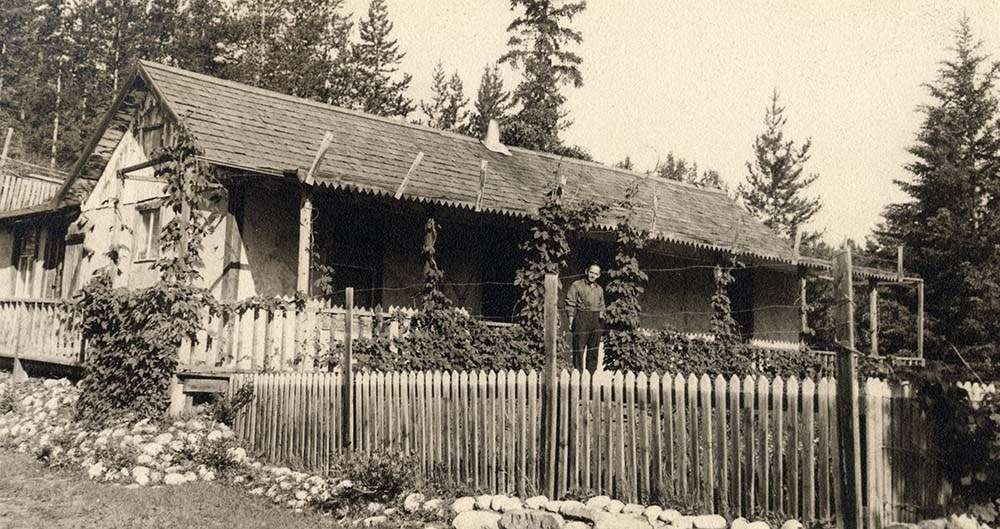
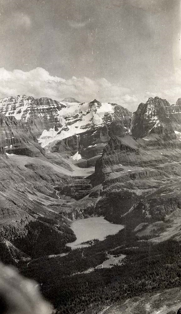
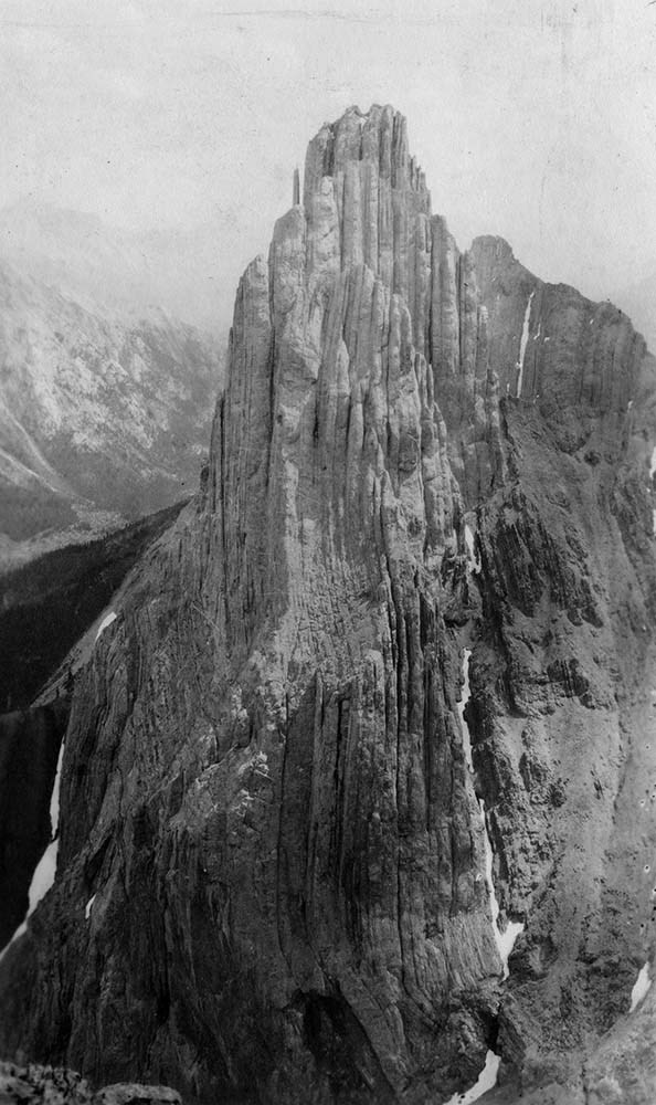
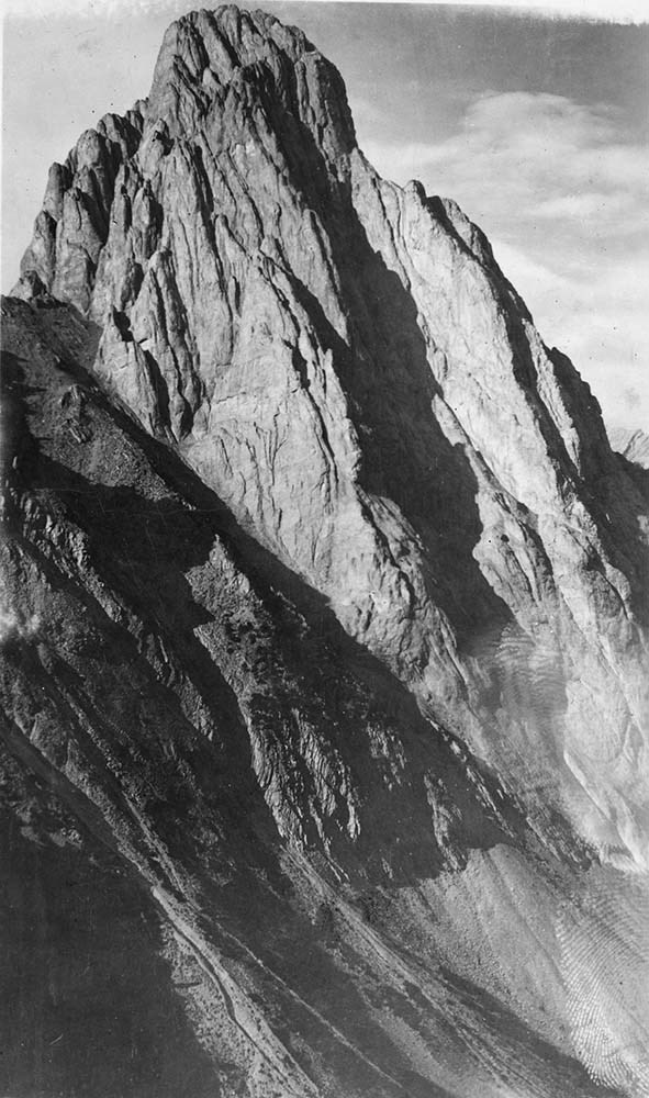
Canadian Rockies Photograph Album
https://archives.whyte.org/en/permalink/descriptions3599
- Part Of
- Lawrence Grassi fonds
- Scope & Content
- File pertains to a photo album that Includes an assortment of views of the Canadian Rockies; mainly duplicates of those images in Series I. Landscape Photographs. Item-level inventory available.
- Date Range
- [ca. 1930-1970]
- Reference Code
- V240 / II / A / PD - 624
- Description Level
- 5 / File
- GMD
- Album
- Photograph
6 images
- Part Of
- Lawrence Grassi fonds
- Description Level
- 5 / File
- Fonds Number
- M45 / V240
- Series
- II.A. Landscape photographs
- Sous-Fonds
- V240
- Accession Number
- 3159
- Reference Code
- V240 / II / A / PD - 624
- GMD
- Album
- Photograph
- Date Range
- [ca. 1930-1970]
- Physical Description
- 1 photograph album (180 prints)
- History / Biographical
- See fonds level description
- Scope & Content
- File pertains to a photo album that Includes an assortment of views of the Canadian Rockies; mainly duplicates of those images in Series I. Landscape Photographs. Item-level inventory available.
- Name Access
- Grassi, Lawrence
- Subject Access
- Activities
- Alpine Club of Canada
- Animals
- Cabins and shelters
- Camps
- Environment and Nature
- Exploration
- Family and personal life
- Grassi Lakes
- Home
- Kananaskis Country
- Lake O'Hara region
- Mountains
- Parks
- Provincial parks and reserves
- Scenery
- Trails
- Trail making
- Travel
- Geographic Access
- Canmore
- Lake Louise
- Lake O'Hara
- Banff
- Banff National Park
- Yoho National Park
- Kananaskis
- Alberta
- British Columbia
- Canada
- Language
- English
- Title Source
- Title based on contents of file
- Processing Status
- Processed
Images

This material is presented as originally created; it may contain outdated cultural descriptions and
potentially offensive content.
Read more.
Maps of Banff and Western Canada
https://archives.whyte.org/en/permalink/descriptions54772
- Part Of
- Luxton family fonds
- Scope & Content
- File consists of 9 printed maps, b&w and col. [including zoning and topographical maps] depicting the Town of Banff and Banff National Park, the Rocky Mountains Forest Reserve, the Moose Mountain region, Medicine Hat, and the province of Alberta. File includes Trail Riders' Map of the Canadian Rock…
- Date Range
- 1912
- 1914
- 1924
- 1926
- 1932
- 1957
- [1970-1980]
- Reference Code
- LUX / II / C5 / 25
- Description Level
- 5 / File
- GMD
- Textual record
- Published record
- Map
- Part Of
- Luxton family fonds
- Description Level
- 5 / File
- Fonds Number
- LUX
- Series
- LUX / II / C : Personal
- Sous-Fonds
- LUX / II : Eleanor Luxton sous-fonds
- Sub-Series
- LUX / II / C5 : Other
- Accession Number
- LUX
- Reference Code
- LUX / II / C5 / 25
- Date Range
- 1912
- 1914
- 1924
- 1926
- 1932
- 1957
- [1970-1980]
- Physical Description
- 9 maps : b&w and col. ; 168 x 71 cm or smaller
- Scope & Content
- File consists of 9 printed maps, b&w and col. [including zoning and topographical maps] depicting the Town of Banff and Banff National Park, the Rocky Mountains Forest Reserve, the Moose Mountain region, Medicine Hat, and the province of Alberta. File includes Trail Riders' Map of the Canadian Rockies which has smaller maps of Waterton Lakes, Glacier, Revelstoke, and other national parks printed on the back. Map of Medicine Hat includes annotated storage envelope with dimensions written on the front.
- Subject Access
- Cartography
- Geography
- Land use
- Government
- Travel
- National parks and reserves
- Geographic Access
- Canada
- Alberta
- Banff
- Banff National Park
- Medicine Hat
- Rocky Mountains
- Glacier National Park
- Revelstoke
- Waterton Lakes National Park
- Reproduction Restrictions
- Restrictions may apply
- Language
- English
- Title Source
- Title based on contents of file
- Processing Status
- Processed
This material is presented as originally created; it may contain outdated cultural descriptions and
potentially offensive content.
Read more.
Banff National Park and Lake Louise maps
https://archives.whyte.org/en/permalink/descriptions54945
- Scope & Content
- File consists of two folded maps and a small clipping [possibly top or bottom portion from a different map or one of maps in file]. One map is of Banff National Park and one is of Lake Louise [1959]. Banff National Park map has black pencil tracings over trail section near the bottom of the map and…
- Date Range
- 1959
- [1960-1970]
- Reference Code
- M545 / V / 53
- Description Level
- 5 / File
- GMD
- Textual record
- Published record
- Map
- Description Level
- 5 / File
- Fonds Number
- M545 / V635
- Series
- M545 / V : Administrative records
- Sous-Fonds
- M545
- Accession Number
- 8235
- Reference Code
- M545 / V / 53
- Date Range
- 1959
- [1960-1970]
- Physical Description
- 0.5 cm of textual records (2 maps ; 60.5 x 57.5 and 60 x 56.5 cm)
- Scope & Content
- File consists of two folded maps and a small clipping [possibly top or bottom portion from a different map or one of maps in file]. One map is of Banff National Park and one is of Lake Louise [1959]. Banff National Park map has black pencil tracings over trail section near the bottom of the map and annotation in bottom right corner which reads "Natural Bridge". Lake Louise map produced by the Government of Canada.
- Subject Access
- Banff National Park
- Environment
- Geography
- Map
- Lake Louise
- Travel
- Government
- National parks and reserves
- Trails
- Geographic Access
- Canada
- Alberta
- Banff National Park
- Lake Louise
- Language
- English
- Conservation
- Clipping stored in mylar due to significant staining and residue from tape
- Items kept folded [not placed in mylar] due to mass production of content and minimal/no annotations
- Title Source
- Title based on contents of file
- Processing Status
- Processed
This material is presented as originally created; it may contain outdated cultural descriptions and
potentially offensive content.
Read more.
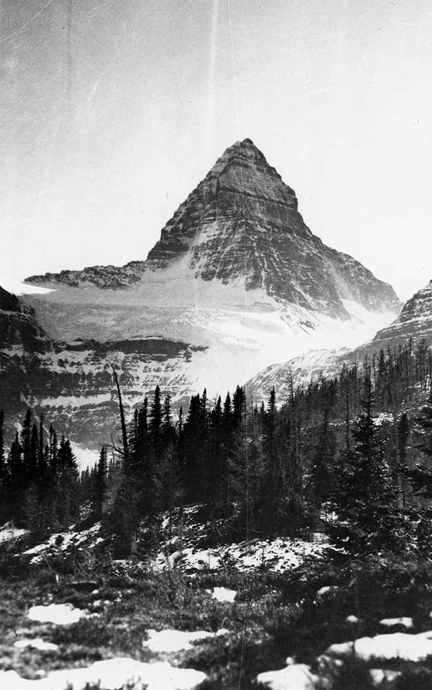
Peter and Catharine Whyte fonds
https://archives.whyte.org/en/permalink/descriptions36
- Part Of
- Peter and Catharine Whyte fonds
- Scope & Content
- Fonds consists of papers, photographs and sound recordings of Peter and Catharine Whyte and the papers and photographs of their respective families. Consists of three sous-fonds: V683, S37 and M36. M36 and S37 consists of three series. Series I: Peter and Catharine Whyte, Series II: Robb and Morse …
- Date Range
- 1856-1980
- Reference Code
- M36 / S37 / V683
- Description Level
- 1 / Fonds
- GMD
- Drawing
- Motion picture
- Film
- Photograph
- Album
- Ambrotype
- Cased photograph
- Daguerreotype
- Negative
- Photograph print
- Postcard
- Tintype
- Transparency
- Sound recording
- Cassette
- Reel to reel
- Textual record
- Plan
- Poster
- Private record
- Published record
1 Electronic Resource
- Part Of
- Peter and Catharine Whyte fonds
- Description Level
- 1 / Fonds
- Fonds Number
- M36 / V683 / S37
- Sous-Fonds
- TBD
- Accession Number
- 3069 and various
- Reference Code
- M36 / S37 / V683
- GMD
- Drawing
- Motion picture
- Film
- Photograph
- Album
- Ambrotype
- Cased photograph
- Daguerreotype
- Negative
- Photograph print
- Postcard
- Tintype
- Transparency
- Sound recording
- Cassette
- Reel to reel
- Textual record
- Plan
- Poster
- Private record
- Published record
- Other Title Info
- Also known as the Whyte family fonds
- Date Range
- 1856-1980
- Physical Description
- 25 m of textual records. -- ca.46,000 photographs : prints, albums, postcards, cased photographs, transparencies, negatives. -- 178 sound recordings : audio tape reels, audio tape cassettes. -- 6 motion pictures (and film strips)
- History / Biographical
- Peter and Catharine Whyte were artists, photographers, outdoor enthusiasts, travelers, philanthropists and cultural workers at Banff, Alberta, Canada. Peter Whyte, 1905-1966, was born at Banff in 1905 to pioneer merchant Dave White and Annie (Curren) White. He was an accomplished skier and ski jumper and one of the region's first native-born painters with an intimate knowledge of the mountains and was an active photographer from ca.1920 until the 1950s. Peter Whyte studied art at the Otis Art Institute, Los Angeles, 1923-1924, and at the School of the Museum of Fine Arts at Boston, 1925, where he met Catharine Robb. Catharine Robb Whyte, 1906-1979, was born in 1906 at Concord, Massachusetts and grew up amongst the wealth and creativity of the Robb and Morse families. She studied at the School of the Museum of Fine Arts at Boston, 1925-1929.
- Following their marriage in 1930, the Whytes pursued a life of painting, photography, hiking, skiing and travelling. Their log home and studio in Banff became a focal point for their artist friends, Stoney Indians and local pioneers. Catharine shared Pete's involvement in skiing and hiking organizations and together they managed Skoki Lodge from 1932-1934. In following years, the Whytes travelled extensively. During the Second World War, Peter served in the reserve army, with the Royal Canadian Air Force as a photographer and, briefly, as an official war artist. Catharine continued to paint and maintain their home and, when possible, accompanied Pete to his military postings. In civilian life, Pete resumed his art career, explored new photographic techniques and sculpted.
- Throughout the 1950s and 1960s, the Whytes formulated plans for a foundation to preserve the art and history of the Canadian Rockies. Plans for a building to house an archives, public library and gallery were in preparation when Pete died in 1966. The Peter Whyte Foundation was named in his honour. Catharine immersed herself in the development of what is now the Whyte Museum of the Canadian Rockies, in the cultural community, painting, outdoor activity, travel and work with the Stoney First Nations. She became a more active photographer, recording her travels and outdoor pursuits. She served in an official capacity with numerous cultural and charitable organizations, was a patron to individuals studying art and music, and supported numerous causes relating to the Stoney First Nations. Catharine also supported causes related to multiculturalism, regional culture and recreation, and cancer research. Despite her modesty and often anonymous patronage of causes, Catharine was recognized with numerous awards and honours, including the Order of Canada in 1978. She died in Banff in 1979.
- Scope & Content
- Fonds consists of papers, photographs and sound recordings of Peter and Catharine Whyte and the papers and photographs of their respective families. Consists of three sous-fonds: V683, S37 and M36. M36 and S37 consists of three series. Series I: Peter and Catharine Whyte, Series II: Robb and Morse families, Series III: White and Curren families. Within Series I, there are four Sub-series: Series: A. Catharine Robb Whyte papers; B. Peter Whyte papers; C. Peter and Catharine Whyte papers accessioned after 2017; D. Peter and Catharine Whyte sound recordings.
- Name Access
- Whyte, Peter
- Whyte, Catharine
- Subject Access
- Arts
- Communications
- Environment
- Exploration, discovery and travel
- Family and personal life
- First nations
- Sports, recreation and leisure
- Access Restrictions
- Some restriction/s on access
- Copyright, privacy, commercial use and other restrictions may apply
- Language
- Language is English
- Finding Aid
- Finding aids and reference tools: arrangement outline
- sous-fonds, series and file description for textual
- sub-series and group description for photographs
- item description, subject/proper name index, and summaries for sound recordings
- reference copies for sound recordings
- Creator
- Whyte, Peter
- Whyte, Catharine
- Category
- Arts
- Communications
- Environment
- Exploration, discovery and travel
- Family and personal life
- First nations
- Sports, recreation and leisure
- Title Source
- Title based on contents of fonds
- Processing Status
- Processed
Electronic Resources
This material is presented as originally created; it may contain outdated cultural descriptions and
potentially offensive content.
Read more.
[Athabaska Pass 83D/9, Alta.-B.C.]
https://archives.whyte.org/en/permalink/catalogue23457
- Medium
- Library - Maps and blueprints (unannotated; published)
- Map
- Published Date
- 1971
- Publisher
- Dept. of Energy, Mines and Resources
- Call Number
- NTS
- 83D/8
- Publisher
- Dept. of Energy, Mines and Resources
- Published Date
- 1971
- Physical Description
- 1 map : col
- Scale
- Scale: 1:50,000
- Relief: Contour Interval 100 ft.
- Subjects
- Athabaska Pass
- Alberta/British Columbia
- Notes
- National Topographic System
- Accession Number
- 7030
- 3000
- Call Number
- NTS
- 83D/8
- Collection
- Archives Library
This material is presented as originally created; it may contain outdated cultural descriptions and
potentially offensive content.
Read more.
[Azure River 83D/12 B.C.]
https://archives.whyte.org/en/permalink/catalogue23458
- Medium
- Library - Maps and blueprints (unannotated; published)
- Map
- Published Date
- 1972
- Publisher
- Department of Energy, Mines and Resources
- Call Number
- NTS
- 83D/12
- Publisher
- Department of Energy, Mines and Resources
- Published Date
- 1972
- Physical Description
- 1 map : col
- Scale
- Scale: 1:50,000
- Relief: Contour interval 100 ft.
- Subjects
- Azure River
- British Columbia
- Notes
- National Topographic System
- Accession Number
- 7000
- 7030
- Call Number
- NTS
- 83D/12
- Collection
- Archives Library
This material is presented as originally created; it may contain outdated cultural descriptions and
potentially offensive content.
Read more.