Narrow Results By
- Peter Whyte (1905 – 1966, Canadian) 33
- Barbara Milne (1956 – , Canadian) 26
- Charles John Collings (1848 – 1931, British) 19
- Catharine Robb Whyte, O. C. (1906 – 1979, Canadian) 16
- Pond, Peter 6
- Peter or Catharine Whyte 4
- Henry George Glyde (1906 – 1998, Canadian) 3
- Christenson, O.A. 2
- Guest, Robert 2
- Maureen Enns (1949 – , Canadian) 2
- Wheeler, Arthur Oliver 2
- Ayres, W.S. 1
- Photograph 29371
- Negative 17287
- Library - Book (including soft-cover and pamphlets) 14314
- Transparency 3187
- Library - Periodical 3157
- Library - Postcard 2944
- Lantern slide 2559
- Textual record 2197
- Map 2131
- Photograph print 2109
- Library - Maps and blueprints (unannotated; published)
- Graphite Drawing 1627
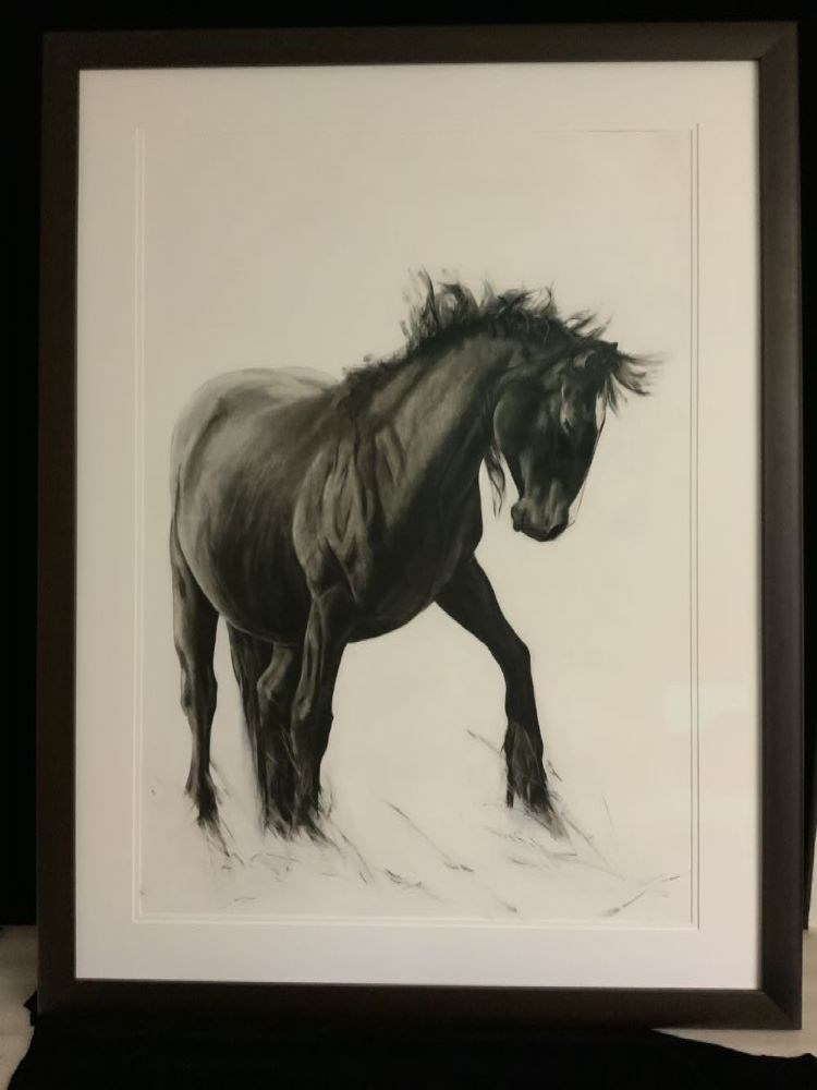
The Diva Takes a Bow
https://archives.whyte.org/en/permalink/artifactenm.03.02
- Date
- 2009
- Medium
- charcoal on primed paper
- Catalogue Number
- EnM.03.02
- Description
- A charcoal drawing of a black horse with head down is drawn in 3/4 view emerging from the left side of the paper. It’s hooves are left unfinished and dissolve into loose wisps. It’s mane is loose and flowing.
1 image
- Title
- The Diva Takes a Bow
- Date
- 2009
- Medium
- charcoal on primed paper
- Dimensions
- 101.6 x 76.2 cm
- Description
- A charcoal drawing of a black horse with head down is drawn in 3/4 view emerging from the left side of the paper. It’s hooves are left unfinished and dissolve into loose wisps. It’s mane is loose and flowing.
- Subject
- horse
- Credit
- Purchased from Maureen Enns, Cochrane, 2022
- Catalogue Number
- EnM.03.02
Images
This material is presented as originally created; it may contain outdated cultural descriptions and
potentially offensive content.
Read more.
National Museum of Ethnology : Meiji crafts from across the sea : special exhibition of the Morse collection : exhibit plan
https://archives.whyte.org/en/permalink/catalogue24929
- Medium
- Library - Maps and blueprints (unannotated; published)
- Published Date
- 1990
- Author
- National Museum of Ethnology
- Publisher
- Tokyo, Japan : Total Media Development Institute Co. Ltd.
- Call Number
- 06.1 N19m OS
1 website
- Author
- National Museum of Ethnology
- Responsibility
- National Museum of Ethnology
- Publisher
- Tokyo, Japan : Total Media Development Institute Co. Ltd.
- Published Date
- 1990
- Physical Description
- 12 pages
- Scale
- 1 / 100
- 1 / 20
- 1 / 30
- Abstract
- Pertains to the exhibit plan for the Morse Collection in March of 1990 at the National Museum of Ethnology in Osaka, Japan
- Contents
- 1F Plan
- 2F Plan
- B1F Plan
- A-A
- B-B
- Exhibit Case
- Large Exhibit Case
- Shelf Case
- Shadow Picture
- B1F
- Exhibit Tool
- Accession Number
- 2014.8340
- Call Number
- 06.1 N19m OS
- Collection
- Archives Library
- URL Notes
- National Museum of Ethnology website
Websites
This material is presented as originally created; it may contain outdated cultural descriptions and
potentially offensive content.
Read more.
[Mount Peck 82 J/3 East - B.C.]
https://archives.whyte.org/en/permalink/catalogue23762
- Medium
- Library - Maps and blueprints (unannotated; published)
- Map
- Published Date
- 1966
- Publisher
- Dept. of Mines and Technical Surveys
- Call Number
- NTS
- 82J/3E
- Publisher
- Dept. of Mines and Technical Surveys
- Published Date
- 1966
- Physical Description
- Colour
- Scale
- Scale: 1:50,000
- Relief: Contour interval 100'
- Subjects
- Mount Peck 82 J/3 East - B.C.
- Notes
- National Topographic System
- Accession Number
- 718
- Call Number
- NTS
- 82J/3E
- Collection
- Archives Library
This material is presented as originally created; it may contain outdated cultural descriptions and
potentially offensive content.
Read more.
[Mount Peck 82 J/3 West - B.C.]
https://archives.whyte.org/en/permalink/catalogue23763
- Medium
- Library - Maps and blueprints (unannotated; published)
- Map
- Published Date
- 1966
- Publisher
- Dept. of Mines and Technical Surveys
- Call Number
- NTS
- 82J/3W
- Publisher
- Dept. of Mines and Technical Surveys
- Published Date
- 1966
- Physical Description
- Colour
- Scale
- Scale: 1:50,000
- Relief: Contour interval 100'
- Subjects
- Mount Peck 82 J/3 West - B.C.
- Notes
- National Topographic System
- Accession Number
- 718
- Call Number
- NTS
- 82J/3W
- Collection
- Archives Library
This material is presented as originally created; it may contain outdated cultural descriptions and
potentially offensive content.
Read more.
[Mount Queen Bess 92 N/7 East - B.C.]
https://archives.whyte.org/en/permalink/catalogue23764
- Medium
- Library - Maps and blueprints (unannotated; published)
- Map
- Published Date
- 1968
- Publisher
- Department of Energy, Mines and Resources
- Call Number
- NTS
- 92N/7E
- Publisher
- Department of Energy, Mines and Resources
- Published Date
- 1968
- Physical Description
- Colour
- Scale
- Scale: 1:50,000
- Relief: Contour Interval 100 ft.
- Subjects
- Mount Queen Bess 92 N/7 East - B.C.
- Notes
- National Topographic System
- Accession Number
- 3000
- Call Number
- NTS
- 92N/7E
- Collection
- Archives Library
This material is presented as originally created; it may contain outdated cultural descriptions and
potentially offensive content.
Read more.
[Mount Queen Bess 92 N/7 West - B.C.]
https://archives.whyte.org/en/permalink/catalogue23765
- Medium
- Library - Maps and blueprints (unannotated; published)
- Map
- Published Date
- 1968
- Publisher
- Dept. of Energy, Mines and Resources
- Call Number
- NTS
- 92N/7W
- Publisher
- Dept. of Energy, Mines and Resources
- Published Date
- 1968
- Physical Description
- Colour
- Scale
- Scale: 1:50,000
- Relief: Contour Interval 100 ft.
- Subjects
- Mount Queen Bess 92 N/7 West - B.C.
- Notes
- National Topographic System
- Accession Number
- 3000
- Call Number
- NTS
- 92N/7W
- Collection
- Archives Library
This material is presented as originally created; it may contain outdated cultural descriptions and
potentially offensive content.
Read more.
[Mount Rae 82 J/10 West - Alberta]
https://archives.whyte.org/en/permalink/catalogue23766
- Medium
- Library - Maps and blueprints (unannotated; published)
- Map
- Published Date
- 1954
- Publisher
- Dept. of Mines and Technical Surveys
- Call Number
- NTS
- 82J/10W
- Publisher
- Dept. of Mines and Technical Surveys
- Published Date
- 1954
- Physical Description
- Colour
- Scale
- Scale: 1:50,000
- Relief: Contour interval 100'
- Subjects
- Mount Rae 82 J/10 West - Alberta
- Notes
- National Topographic System
- Call Number
- NTS
- 82J/10W
- Collection
- Archives Library
This material is presented as originally created; it may contain outdated cultural descriptions and
potentially offensive content.
Read more.
Mount Revelstoke, British Columbia
https://archives.whyte.org/en/permalink/catalogue23767
- Medium
- Library - Maps and blueprints (unannotated; published)
- Map
- Published Date
- 1978
- Publisher
- Ottawa : Surveys and Mapping Branch, Dept. of Energy, Mines and Resources
- Edition
- 2d ed.
- Call Number
- NTS
- 82M/1
- Edition
- 2d ed.
- Publisher
- Ottawa : Surveys and Mapping Branch, Dept. of Energy, Mines and Resources
- Published Date
- 1978
- Physical Description
- 1 map : col
- Scale
- 1:50,000
- Subjects
- Revelstoke, Mount
- Mount Revelstoke (B.C.)
- Accession Number
- 27,000
- Call Number
- NTS
- 82M/1
- Collection
- Archives Library
This material is presented as originally created; it may contain outdated cultural descriptions and
potentially offensive content.
Read more.
[Mount Revelstoke 82 M/1 East - B.C.]
https://archives.whyte.org/en/permalink/catalogue23768
- Medium
- Library - Maps and blueprints (unannotated; published)
- Map
- Published Date
- 1963
- Publisher
- Dept. of Mines and Technical Surveys
- Call Number
- NTS
- 82M/1E
- Publisher
- Dept. of Mines and Technical Surveys
- Published Date
- 1963
- Physical Description
- Colour
- Scale
- Scale: 1:50,000
- Relief: Contour interval 100'
- Subjects
- Mount Revelstoke 82 M/1 East - B.C.
- Notes
- National Topographic System
- Call Number
- NTS
- 82M/1E
- Collection
- Archives Library
This material is presented as originally created; it may contain outdated cultural descriptions and
potentially offensive content.
Read more.
[Mount Revelstoke 82 M/1 West - B.C.]
https://archives.whyte.org/en/permalink/catalogue23769
- Medium
- Library - Maps and blueprints (unannotated; published)
- Map
- Published Date
- 1963
- Publisher
- Dept. of Mines and Technical Surveys
- Call Number
- NTS
- 82M/1W
- Publisher
- Dept. of Mines and Technical Surveys
- Published Date
- 1963
- Physical Description
- Colour
- Scale
- Scale: 1:50,000
- Relief: Contour interval 100'
- Subjects
- Mount Revelstoke 82 M/1 West - B.C.
- Notes
- National Topographic System
- Call Number
- NTS
- 82M/1W
- Collection
- Archives Library
This material is presented as originally created; it may contain outdated cultural descriptions and
potentially offensive content.
Read more.
[Mount Robson 83 E/3 East - B.C.-Alta.]
https://archives.whyte.org/en/permalink/catalogue23770
- Medium
- Library - Maps and blueprints (unannotated; published)
- Map
- Published Date
- 1966
- Publisher
- Dept. of Mines and Technical Surveys
- Call Number
- NTS
- 83E/3E
- Publisher
- Dept. of Mines and Technical Surveys
- Published Date
- 1966
- Physical Description
- Colour
- Scale
- Scale: 1:50,000
- Relief: Contour interval 100'
- Notes
- National Topographic System
- Call Number
- NTS
- 83E/3E
- Collection
- Archives Library
This material is presented as originally created; it may contain outdated cultural descriptions and
potentially offensive content.
Read more.
[Mount Robson 83 E/3 West - B.C.-Alta.]
https://archives.whyte.org/en/permalink/catalogue23771
- Medium
- Library - Maps and blueprints (unannotated; published)
- Map
- Published Date
- 1966
- Publisher
- Dept. of Mines and Technical Surveys
- Call Number
- NTS
- 83E/3W
- Publisher
- Dept. of Mines and Technical Surveys
- Published Date
- 1966
- Physical Description
- Colour
- Scale
- Scale: 1:50,000
- Relief: Contour interval 100'
- Notes
- National Topographic System
- Call Number
- NTS
- 83E/3W
- Collection
- Archives Library
This material is presented as originally created; it may contain outdated cultural descriptions and
potentially offensive content.
Read more.
[Mount Sir Alexander]
https://archives.whyte.org/en/permalink/catalogue23772
- Medium
- Library - Maps and blueprints (unannotated; published)
- Map
- Published Date
- 1975
- Publisher
- Dept. of Energy Mines & Resources
- Call Number
- NTS
- 93H/16
- Publisher
- Dept. of Energy Mines & Resources
- Published Date
- 1975
- Scale
- 1:50,000
- Subjects
- Mount Sir Alexander
- Notes
- National Topographic System
- Accession Number
- 11,500
- Call Number
- NTS
- 93H/16
- Collection
- Archives Library
This material is presented as originally created; it may contain outdated cultural descriptions and
potentially offensive content.
Read more.
[Mount Sir Sanford, B.C.]
https://archives.whyte.org/en/permalink/catalogue23773
- Medium
- Library - Maps and blueprints (unannotated; published)
- Map
- Published Date
- 1980
- Publisher
- Dept of Energy Mines and Resources
- Edition
- Edition 2
- Call Number
- NTS
- 82N/12
- Edition
- Edition 2
- Publisher
- Dept of Energy Mines and Resources
- Published Date
- 1980
- Physical Description
- Colour
- Scale
- Scale: 1:50,000
- Relief: Contour Interval 100 ft.
- Subjects
- Mount Sir Sanford, B.C.
- Notes
- National Topographic System
- Accession Number
- 13,000
- Call Number
- NTS
- 82N/12
- Collection
- Archives Library
This material is presented as originally created; it may contain outdated cultural descriptions and
potentially offensive content.
Read more.
[Mount Sir Sandford 82 N/12 East - B.C.]
https://archives.whyte.org/en/permalink/catalogue23774
- Medium
- Library - Maps and blueprints (unannotated; published)
- Map
- Published Date
- 1964
- Publisher
- Dept. of Mines and Technical Surveys
- Call Number
- NTS
- 82N/12E
- Publisher
- Dept. of Mines and Technical Surveys
- Published Date
- 1964
- Physical Description
- Colour
- Scale
- Scale: 1:50,000
- Relief: Contour interval 100'
- Notes
- National Topographic System
- Accession Number
- 717
- Call Number
- NTS
- 82N/12E
- Collection
- Archives Library
This material is presented as originally created; it may contain outdated cultural descriptions and
potentially offensive content.
Read more.
[Mount Sir Sandford 82 N/12 West - B.C.]
https://archives.whyte.org/en/permalink/catalogue23775
- Medium
- Library - Maps and blueprints (unannotated; published)
- Map
- Published Date
- 1964
- Publisher
- Dept. of Mines and Technical Surveys
- Call Number
- NTS
- 82N/12W
- Publisher
- Dept. of Mines and Technical Surveys
- Published Date
- 1964
- Physical Description
- Colour
- Scale
- Scale: 1:50,000
- Relief: Contour interval 100'
- Notes
- National Topographic System
- Accession Number
- 717
- Call Number
- NTS
- 82N/12W
- Collection
- Archives Library
This material is presented as originally created; it may contain outdated cultural descriptions and
potentially offensive content.
Read more.
Topographic map of the Mount Turner region in the Yukon Territories, Ogilvie Mountains. Clear Creek
https://archives.whyte.org/en/permalink/catalogue23776
- Medium
- Library - Maps and blueprints (unannotated; published)
- Map
- Published Date
- 1978
- Publisher
- D.E.M.R.
- Call Number
- NTS
- 116H/8
- Publisher
- D.E.M.R.
- Published Date
- 1978
- Scale
- 1:50,000
- Subjects
- Mount Turner - Y.T.
- Accession Number
- 11,500
- Call Number
- NTS
- 116H/8
- Collection
- Archives Library
This material is presented as originally created; it may contain outdated cultural descriptions and
potentially offensive content.
Read more.
[Mount Urquhart 92H/12 East - B.C.]
https://archives.whyte.org/en/permalink/catalogue23777
- Medium
- Library - Maps and blueprints (unannotated; published)
- Map
- Published Date
- 1955
- Publisher
- Department of Mines and Technical Surveys
- Call Number
- NTS
- 92H/12E
- Publisher
- Department of Mines and Technical Surveys
- Published Date
- 1955
- Physical Description
- Colour
- Scale
- Scale: 1:50,000
- Relief: Contour interval 100 ft.
- Subjects
- Mount Urquhart 92H/12 East - B.C.
- Notes
- National Topographic System
- Accession Number
- 7000
- Call Number
- NTS
- 92H/12E
- Collection
- Archives Library
This material is presented as originally created; it may contain outdated cultural descriptions and
potentially offensive content.
Read more.
[Mount Urquhart 92H/12West - B.C]
https://archives.whyte.org/en/permalink/catalogue23778
- Medium
- Library - Maps and blueprints (unannotated; published)
- Map
- Published Date
- 1960
- Publisher
- Department of Mines and Technical Surveys
- Call Number
- NTS
- 92H/12W
- Publisher
- Department of Mines and Technical Surveys
- Published Date
- 1960
- Physical Description
- Colour
- Scale
- Scale: 1:50,000
- Relief: Contour interval 100 ft.
- Subjects
- Mount Urquhart 92H/12West - B.C
- Notes
- National Topographic System
- Accession Number
- 7000
- Call Number
- NTS
- 92H/12W
- Collection
- Archives Library
This material is presented as originally created; it may contain outdated cultural descriptions and
potentially offensive content.
Read more.
[Mount Waddington]
https://archives.whyte.org/en/permalink/catalogue23779
- Medium
- Library - Maps and blueprints (unannotated; published)
- Map
- Published Date
- 1980
- Publisher
- Dept of Energy Mines and Resources
- Edition
- 2
- Call Number
- NTS
- 92N/6
- Edition
- 2
- Publisher
- Dept of Energy Mines and Resources
- Published Date
- 1980
- Physical Description
- Colour
- Scale
- Scale: 1:50,000
- Relief: Contour Interval 100 ft.
- Subjects
- Mount Waddington
- Notes
- National Topographic System
- Accession Number
- 13,000
- Call Number
- NTS
- 92N/6
- Collection
- Archives Library
This material is presented as originally created; it may contain outdated cultural descriptions and
potentially offensive content.
Read more.