Narrow Results By
- Catharine Robb Whyte, O. C. (1906 – 1979, Canadian) 32
- Peter Whyte (1905 – 1966, Canadian) 32
- Charles John Collings (1848 – 1931, British) 24
- Ernest C. W Lamarque (1879 – 1970, Canadian) 7
- Peter or Catharine Whyte 4
- James (Sr.) Simpson (1877 – 1972, Canadian) 3
- Adeline Baxter (1881 – 1959) 1
- Carter, N.M. 1
- Chalifour, J.E., Chief Geographer 1
- Emily Carr (1871 – 1945, Canadian) 1
- Louis Agassiz Fuertes (1874 – 1927, American) 1
- Mary Augusta Catharine Heister Reid (1854 – 1921, American, Canadian) 1
Map of Pelly, Ross and Gravel Rivers
https://archives.whyte.org/en/permalink/catalogue24369
- Medium
- Library - Maps and blueprints (unannotated; published)
- Map
- Published Date
- 1910
- Publisher
- Dept. of Mines and Geological Survey
- Call Number
- C8-1.3
- Publisher
- Dept. of Mines and Geological Survey
- Published Date
- 1910
- Scale
- 8 miles to 1 inch
- Subjects
- Yukon and North West Territories
- Notes
- Sources of info: G.M. Dawson, R.G. McConn., J. Keele, W. Ogilvie
- Accession Number
- 576
- Call Number
- C8-1.3
- Collection
- Archives Library
This material is presented as originally created; it may contain outdated cultural descriptions and
potentially offensive content.
Read more.
[Alberta] South-central portion
https://archives.whyte.org/en/permalink/catalogue24416
- Medium
- Library - Maps and blueprints (unannotated; published)
- Map
- Published Date
- 1910
- Publisher
- Dept. of the Interior, Ottawa
- Call Number
- C9-3.1
- Publisher
- Dept. of the Interior, Ottawa
- Published Date
- 1910
- Scale
- Bench marks
- Subjects
- Alberta
- Notes
- 1 duplicate in map room - Accn. 400
- Accession Number
- 400
- Call Number
- C9-3.1
- Collection
- Archives Library
This material is presented as originally created; it may contain outdated cultural descriptions and
potentially offensive content.
Read more.
Sectional map
https://archives.whyte.org/en/permalink/catalogue24464
- Medium
- Library - Maps and blueprints (unannotated; published)
- Map
- Published Date
- 1910
- Publisher
- Dept. of the Interior, Ottawa
- Call Number
- C9-6.4
- Publisher
- Dept. of the Interior, Ottawa
- Published Date
- 1910
- Scale
- 6 miles: 1 inch
- Subjects
- Calgary Sheet
- Accession Number
- 400
- Call Number
- C9-6.4
- Collection
- Archives Library
This material is presented as originally created; it may contain outdated cultural descriptions and
potentially offensive content.
Read more.
Sectional map
https://archives.whyte.org/en/permalink/catalogue24465
- Medium
- Library - Maps and blueprints (unannotated; published)
- Map
- Published Date
- 1910
- Publisher
- Department of the Interior, Ottawa
- Call Number
- C9-6.6
- Publisher
- Department of the Interior, Ottawa
- Published Date
- 1910
- Scale
- 6 miles: 1 inch
- Subjects
- Rocky Mountain House Sheet
- Accession Number
- 400
- Call Number
- C9-6.6
- Collection
- Archives Library
This material is presented as originally created; it may contain outdated cultural descriptions and
potentially offensive content.
Read more.
Map of the Columbia Valley Irrigated Fruitlands of the Windermere district
https://archives.whyte.org/en/permalink/catalogue24532
- Medium
- Library - Maps and blueprints (unannotated; published)
- Map
- Published Date
- 1910
- Call Number
- C10-6.1
- Published Date
- 1910
- Scale
- Scale: 1/2 mile - 1 inch
- Subjects
- Central British Columbia
- Notes
- Photostatic copy from Public Archives
- Accession Number
- 675
- Call Number
- C10-6.1
- Collection
- Archives Library
This material is presented as originally created; it may contain outdated cultural descriptions and
potentially offensive content.
Read more.
- Medium
- Library - Maps and blueprints (unannotated; published)
- Map
- Published Date
- 1910
- Publisher
- Departmentof Interior
- Call Number
- C11-3.8
- Publisher
- Departmentof Interior
- Published Date
- 1910
- Scale
- 100 miles to 1 inch
- Subjects
- Canada
- Railway routes
- Accession Number
- 573
- Call Number
- C11-3.8
- Collection
- Archives Library
This material is presented as originally created; it may contain outdated cultural descriptions and
potentially offensive content.
Read more.
[Rocky Mountains and Yoho Park]
https://archives.whyte.org/en/permalink/catalogue24800
- Medium
- Library - Maps and blueprints (unannotated; published)
- Map
- Published Date
- 1910
- Publisher
- Ottawa : Dept. of the Interior
- Call Number
- C12-1.31
- Publisher
- Ottawa : Dept. of the Interior
- Published Date
- 1910
- Physical Description
- 1 map -- (NMC0014969)
- Scale
- indeterminable
- Notes
- Title information taken from notes pencilled on reverse
- National Map Collection photostat, July 4, 1980
- Call Number
- C12-1.31
- Collection
- Archives Library
This material is presented as originally created; it may contain outdated cultural descriptions and
potentially offensive content.
Read more.
Sectional map [Morley sheet]
https://archives.whyte.org/en/permalink/catalogue15489
- Medium
- Library - Maps and blueprints (unannotated; published)
- Map
- Published Date
- 1910
- Publisher
- Dept. of the Interior, Ottawa
- Call Number
- c9-6.5
- Publisher
- Dept. of the Interior, Ottawa
- Published Date
- 1910
- Scale
- 6 miles to 1 inch
- Accession Number
- 400
- Call Number
- c9-6.5
- Collection
- Archives Library
This material is presented as originally created; it may contain outdated cultural descriptions and
potentially offensive content.
Read more.
- Date
- 1910
- Medium
- watercolour on paper
- Catalogue Number
- CoJ.05.06
- Description
- A landscape scene with three buildings at the left bottom, with blue shaded roof, and three chimneys. -a group of trees to the right of the buildings. -One mountain in the background, ice blue colour on the bottom half to a purple cool top -purple sky with white misty clouds.“The mauves and dark bl…
1 image
- Title
- Near Banff
- Date
- 1910
- Medium
- watercolour on paper
- Dimensions
- 22 x 17 cm
- Description
- A landscape scene with three buildings at the left bottom, with blue shaded roof, and three chimneys. -a group of trees to the right of the buildings. -One mountain in the background, ice blue colour on the bottom half to a purple cool top -purple sky with white misty clouds.“The mauves and dark blues and greens which characterize Collings’ Canadian work already predominate in this early example, and the towering mountain is wonderfully luminous if not fully understood structurally. Lights glowing from three buildings on the left suggest that it is late evening and shine upon the right-hand trees. The latter evidence is some overpainting.” -- “Charles John Collings, 1848-1931” Catalogue Raisonne by Linda Heath
- Credit
- Gift of John Rivette, Seymour Arm, 1982
- Catalogue Number
- CoJ.05.06
Images

This material is presented as originally created; it may contain outdated cultural descriptions and
potentially offensive content.
Read more.
(Miette R-Grand Trunk Pacific Rwy Line)
https://archives.whyte.org/en/permalink/catalogue24500
- Medium
- Library - Maps and blueprints (unannotated; published)
- Map
- Published Date
- August 4, 1910
- Publisher
- Department of the Interior
- Call Number
- C9-7.45
- Publisher
- Department of the Interior
- Published Date
- August 4, 1910
- Physical Description
- 1 map : black and white
- Scale
- 40 chains: 1 inch
- Accession Number
- SG7500
- Call Number
- C9-7.45
- Collection
- Archives Library
This material is presented as originally created; it may contain outdated cultural descriptions and
potentially offensive content.
Read more.
- Medium
- Library - Maps and blueprints (unannotated; published)
- Map
- Published Date
- 1911
- Publisher
- Dept. of the Interior
- Call Number
- C11-2.2
- Publisher
- Dept. of the Interior
- Published Date
- 1911
- Scale
- Scale: 100 miles to 1 inch
- Subjects
- Canada
- Accession Number
- 400
- Call Number
- C11-2.2
- Collection
- Archives Library
This material is presented as originally created; it may contain outdated cultural descriptions and
potentially offensive content.
Read more.
Canadian Pacific Railway
https://archives.whyte.org/en/permalink/catalogue24554
- Medium
- Library - Maps and blueprints (unannotated; published)
- Map
- Published Date
- 1911 (corrected to June, 1912)
- Publisher
- Canadian Pacific Railway
- Call Number
- C11-3.5
- Publisher
- Canadian Pacific Railway
- Published Date
- 1911 (corrected to June, 1912)
- Scale
- Scale: 1" -- 75 miles
- Subjects
- Canada
- Railway routes
- Notes
- The Minneapolis, St. Paul and Sault. Ste. Marie Railway, The Duluth, South Shore and Atlantic Railway and Connections
- Accession Number
- 7000
- Call Number
- C11-3.5
- Collection
- Archives Library
This material is presented as originally created; it may contain outdated cultural descriptions and
potentially offensive content.
Read more.
Mountains of the Continental Divide north of the Yellowhead Pass and Yellowhead Pass Route
https://archives.whyte.org/en/permalink/catalogue24624
- Medium
- Library - Maps and blueprints (unannotated; published)
- Map
- Published Date
- 1911
- Publisher
- Surveyor General's Office
- Call Number
- C3-4.3
- Publisher
- Surveyor General's Office
- Published Date
- 1911
- Physical Description
- Colour
- Scale
- Scale: 1": 2 miles
- Relief: Spot heights
- Subjects
- Mount Robson
- Notes
- 3 Duplicates in map room
- Accession Number
- 400
- 1105
- 2781
- Call Number
- C3-4.3
- Collection
- Archives Library
This material is presented as originally created; it may contain outdated cultural descriptions and
potentially offensive content.
Read more.
Sectional map
https://archives.whyte.org/en/permalink/catalogue24628
- Medium
- Library - Maps and blueprints (unannotated; published)
- Map
- Published Date
- 1911
- Call Number
- C3-5.1
- Published Date
- 1911
- Physical Description
- Black and white
- Scale
- Scale: 3 miles to 1 inch
- Relief: Spot heights
- Subjects
- Donald Sheet
- Notes
- Map of parks - Glacier, Yoho, Rocky Mountains
- Accession Number
- 400
- Call Number
- C3-5.1
- Collection
- Archives Library
This material is presented as originally created; it may contain outdated cultural descriptions and
potentially offensive content.
Read more.
Plan of the city of Calgary
https://archives.whyte.org/en/permalink/catalogue21322
- Medium
- Library - Maps and blueprints (unannotated; published)
- Map
- Published Date
- 1911
- Publisher
- Great West Drafting Co. of Calgary
- Call Number
- C4-4.1
- Publisher
- Great West Drafting Co. of Calgary
- Published Date
- 1911
- Subjects
- Calgary
- Accession Number
- 400
- Call Number
- C4-4.1
- Collection
- Archives Library
This material is presented as originally created; it may contain outdated cultural descriptions and
potentially offensive content.
Read more.
[Rocky Mountains Park]
https://archives.whyte.org/en/permalink/catalogue23195
- Medium
- Library - Maps and blueprints (unannotated; published)
- Map
- Published Date
- 1911
- Publisher
- Dept. of the Interior
- Call Number
- C2-3.9
- Publisher
- Dept. of the Interior
- Published Date
- 1911
- Physical Description
- 1 map : black and white
- Scale
- Scale: 2 miles : 1 inch
- Subjects
- Rocky Mountains Park
- Call Number
- C2-3.9
- Collection
- Archives Library
This material is presented as originally created; it may contain outdated cultural descriptions and
potentially offensive content.
Read more.
[Glacier Park]
https://archives.whyte.org/en/permalink/catalogue23221
- Medium
- Library - Maps and blueprints (unannotated; published)
- Map
- Published Date
- 1911
- Publisher
- Dept. of the Interior
- Call Number
- C2-7.2
- Publisher
- Dept. of the Interior
- Published Date
- 1911
- Physical Description
- 1 map : black and white
- Scale
- Scale: 2 miles to 1 inch
- Relief: Spot heights
- Subjects
- Glacier National Park
- Accession Number
- 400
- Call Number
- C2-7.2
- Collection
- Archives Library
This material is presented as originally created; it may contain outdated cultural descriptions and
potentially offensive content.
Read more.
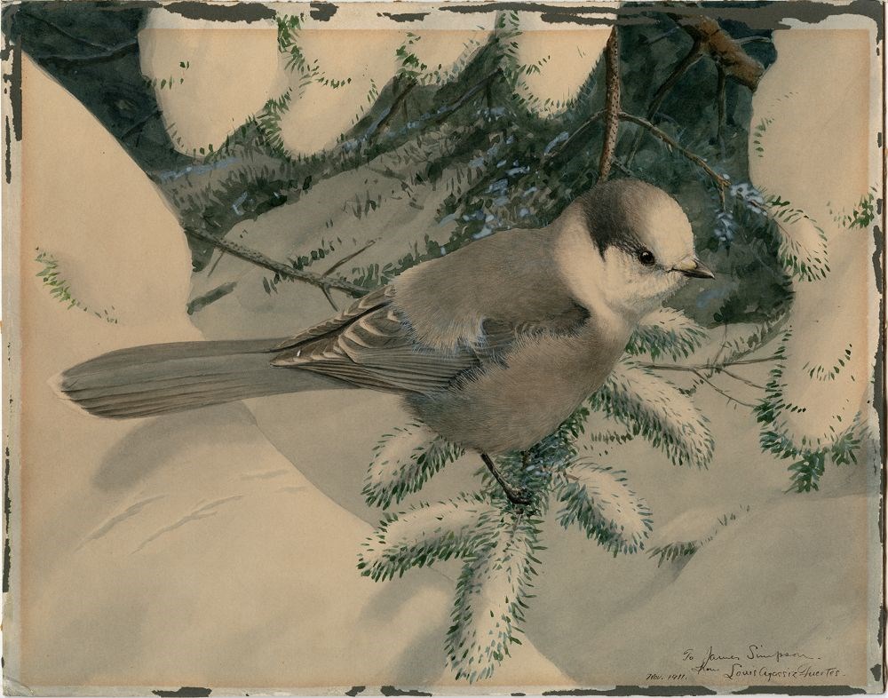
- Date
- 1911
- Medium
- watercolour on paper
- Catalogue Number
- Fel.05.02
- Description
- A grey, white and black chickadee sitting on a snow-capped spruce bough.
1 image
- Title
- Untitled
- Date
- 1911
- Medium
- watercolour on paper
- Dimensions
- 28.0 x 35.5 cm
- Description
- A grey, white and black chickadee sitting on a snow-capped spruce bough.
- Subject
- winter
- bird, chickadee
- Credit
- Gift of Mary Hallock, Fort St. James, 1981
- Catalogue Number
- Fel.05.02
Images
This material is presented as originally created; it may contain outdated cultural descriptions and
potentially offensive content.
Read more.
(junction Athabaska River & Miette River)
https://archives.whyte.org/en/permalink/catalogue24497
- Medium
- Library - Maps and blueprints (unannotated; published)
- Map
- Published Date
- February 22, 1911
- Publisher
- Department of the Interior
- Call Number
- C9-7.45
- Publisher
- Department of the Interior
- Published Date
- February 22, 1911
- Physical Description
- 1 map : black and white
- Scale
- 40 chainsL 1 inch
- Accession Number
- SG7500
- Call Number
- C9-7.45
- Collection
- Archives Library
This material is presented as originally created; it may contain outdated cultural descriptions and
potentially offensive content.
Read more.
(Miette R-G.T.P. Rwy Location Line)
https://archives.whyte.org/en/permalink/catalogue24499
- Medium
- Library - Maps and blueprints (unannotated; published)
- Map
- Published Date
- February 24, 1911
- Publisher
- Department of the Interior
- Call Number
- C9-7.45
- Publisher
- Department of the Interior
- Published Date
- February 24, 1911
- Physical Description
- 1 map : black and white
- Scale
- 40 chainsL 1 inch
- Accession Number
- SG7500
- Call Number
- C9-7.45
- Collection
- Archives Library
This material is presented as originally created; it may contain outdated cultural descriptions and
potentially offensive content.
Read more.