Narrow Results By
- Peter and Catharine Whyte fonds 1817
- Luxton family fonds 404
- Nicholas Morant fonds 242
- George Noble fonds 154
- Crosby family fonds 93
- Bruno Engler fonds 68
- Bill Gibbons fonds 59
- Jim and Dorothy Boyce fonds 54
- Moore family fonds 53
- Bert Riggall fonds 49
- Alpine Club of Canada fonds 45
- George McLean fonds 42
- 1930s 12671
- 1920s 12216
- 1940s 11945
- 1910s 8186
- 1900s 6662
- 1950s
- 1970s 6239
- 1960s 6021
- 1980s 3920
- 1990s 2534
- 2000s 1761
- 1890s 1619
- 2010s 1195
- 1880s 1007
- 1870s 753
- 2020s 237
- 1850s 235
- 1860s 218
- 1800s 104
- 1840s 78
- 1820s 66
- 1830s 66
- 1810s 39
- 1780s 34
- 1790s 17
- 1750s 13
- 1770s 10
- 1700s 6
- 1720s 3
- 1740s 3
- 1760s 3
- 1570s
- 1600s 2
- 1080s 1
- 1300s 1
- 1500s 1
- 1530s 1
- 1550s 1
- 1560s 1
- 1610s 1
- 1620s 1
- 1680s 1
- 1690s 1
- 1710s 1
- 1730s 1
- Medium
- Library - Postcard
- Published Date
- ca. 1959
- Publisher
- Byron Harmon Photos
- Call Number
- V466/PG-B99h-6
1 image
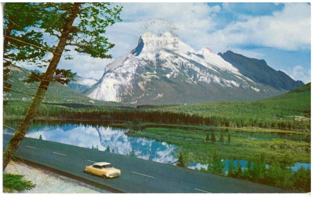
- Variant Title
- Mt. Rundle [Mount Rundle], altitude 9675 feet, and Vermillion Lakes [Vermilion Lakes]
- Responsibility
- Scenic Art
- Place
- Banff, Canada Richmond, California Printed in U.S.A.
- Publisher
- Byron Harmon Photos
- Published Date
- ca. 1959
- Medium
- Library - Postcard
- Notes
- Annotated
- colour
- scenes in natural Colour
- Includes postage stamp
- Accession Number
- 5362
- Call Number
- V466/PG-B99h-6
Images
This material is presented as originally created; it may contain outdated cultural descriptions and
potentially offensive content.
Read more.
- Medium
- Library - Postcard
- Published Date
- ca. 1958
- Publisher
- Byron Harmon Photos
- Call Number
- V151/PG-B99h-1
1 image
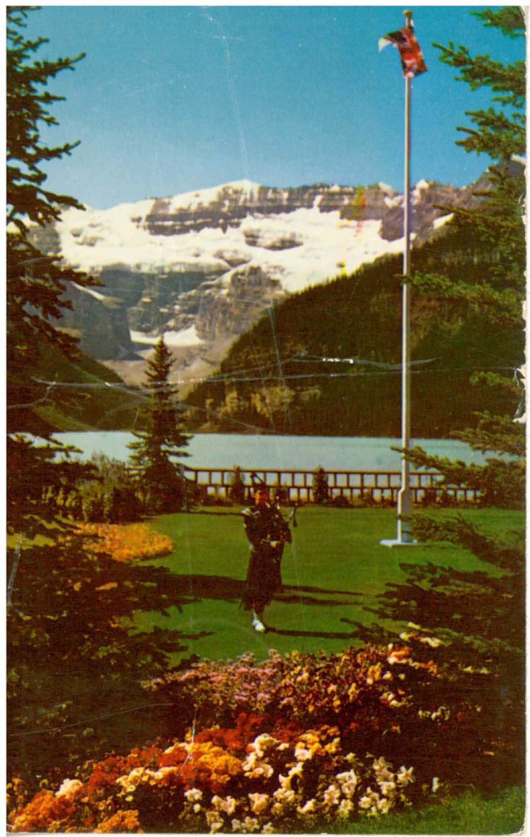
- Variant Title
- "Piping" down the Flag at Lake Louise. Banff National Park. Canadian Rockies
- Responsibility
- Scenic Art
- Place
- Banff, Canada Richmond, California Printed in U.S.A.
- Publisher
- Byron Harmon Photos
- Published Date
- ca. 1958
- Medium
- Library - Postcard
- Notes
- Annotated
- colour
- scenes in natural Colour
- Includes postage stamp
- Accession Number
- 7864
- Call Number
- V151/PG-B99h-1
Images
This material is presented as originally created; it may contain outdated cultural descriptions and
potentially offensive content.
Read more.
The Praeger picture encyclopedia of art; a comprehensive survey of painting, sculpture, architecture and crafts ... from the earliest times to the present day.
https://archives.whyte.org/en/permalink/catalogue20268
- Medium
- Library - Book (including soft-cover and pamphlets)
- Published Date
- c1958
- Publisher
- New York : Frederick A. Praeger
- Call Number
- N31 P7
- Publisher
- New York : Frederick A. Praeger
- Published Date
- c1958
- Physical Description
- 584p. : ill.
- Notes
- Originally published in Germany
- English version prepared with the assistance of James Cleugh [and others] under the supervision of Olive Cook and the editorial staff of Thames and Hudson, London.
- Includes index
- Accession Number
- 3069
- Call Number
- N31 P7
- Location
- Art Library is located in Curatorial Department - Please contact Curatorial Department for access
- Collection
- Art Library
This material is presented as originally created; it may contain outdated cultural descriptions and
potentially offensive content.
Read more.
- Medium
- Library - Book (including soft-cover and pamphlets)
- Published Date
- 1953
- Publisher
- New York : Random House
- Call Number
- ND813 V4 G3
- Responsibility
- Introduction by Joses Ortega y Gasset
- Publisher
- New York : Random House
- Published Date
- 1953
- Physical Description
- (83)p. : plates, ports.
- Accession Number
- 400
- Call Number
- ND813 V4 G3
- Location
- Art Library is located in Curatorial Department - Please contact Curatorial Department for access
- Collection
- Art Library
This material is presented as originally created; it may contain outdated cultural descriptions and
potentially offensive content.
Read more.
Life's picture history of World War II
https://archives.whyte.org/en/permalink/catalogue21202
- Medium
- Library - Book (including soft-cover and pamphlets)
- Published Date
- 1950
- Publisher
- New York : Time Incorporated
- Call Number
- TR815 W6 L5
- Publisher
- New York : Time Incorporated
- Published Date
- 1950
- Physical Description
- 368p. : ill. ports. maps, facsim
- Notes
- Includes index
- Accession Number
- 3069
- Call Number
- TR815 W6 L5
- Location
- Art Library is located in Curatorial Department - Please contact Curatorial Department for access
- Collection
- Art Library
This material is presented as originally created; it may contain outdated cultural descriptions and
potentially offensive content.
Read more.
The family of man
https://archives.whyte.org/en/permalink/catalogue21203
- Medium
- Library - Book (including soft-cover and pamphlets)
- Published Date
- c1955
- Publisher
- New York : Museum of Modern Art
- (New York : Maco Magazine Corporation)
- Call Number
- TR820 F3
- Responsibility
- ... created by Edward Steichen for the Museum of Modern Art ; prologue by Carl Sandburg ; introd. by Edward Steichen
- Publisher
- New York : Museum of Modern Art
- (New York : Maco Magazine Corporation)
- Published Date
- c1955
- Physical Description
- 192p. : ill. port.
- Subjects
- Photography of children
- Photography of women
- Photography of youth
- Photography of men
- Photography, Journalistic
- Accession Number
- 3069
- Call Number
- TR820 F3
- Location
- Art Library is located in Curatorial Department - Please contact Curatorial Department for access
- Collection
- Art Library
This material is presented as originally created; it may contain outdated cultural descriptions and
potentially offensive content.
Read more.
Historical map of Edmonton (Northside) about 1790-1900
https://archives.whyte.org/en/permalink/catalogue21323
- Medium
- Library - Maps and blueprints (unannotated; published)
- Map
- Published Date
- 1958
- Publisher
- Hamly, Edmonton
- Call Number
- C4-4.2
- Publisher
- Hamly, Edmonton
- Published Date
- 1958
- Physical Description
- 1 map : black and white
- Subjects
- Edmonton
- Notes
- Map showing the city north of the river
- Accession Number
- 673
- Call Number
- C4-4.2
- Collection
- Archives Library
This material is presented as originally created; it may contain outdated cultural descriptions and
potentially offensive content.
Read more.
No vanishing race : the Canadian Indian today
https://archives.whyte.org/en/permalink/catalogue5038
- Medium
- Library - Book (including soft-cover and pamphlets)
- Published Date
- (c1955)
- Call Number
- 07.2 N66
- Responsibility
- a symposium by George Dorey (and others)
- Published Date
- (c1955)
- Subjects
- Missionaries
- Call Number
- 07.2 N66
- Collection
- Archives Library
This material is presented as originally created; it may contain outdated cultural descriptions and
potentially offensive content.
Read more.
[Jasper Park - North Sheet]
https://archives.whyte.org/en/permalink/catalogue23183
- Medium
- Library - Maps and blueprints (unannotated; published)
- Map
- Published Date
- 1956
- Publisher
- Dept. of Mines and Technical Surveys
- Call Number
- C2-2.9
- Publisher
- Dept. of Mines and Technical Surveys
- Published Date
- 1956
- Physical Description
- 1 map : col
- Relief: Contour Interval 200'
- Scale
- 1 inch = 3 miles
- Subjects
- Jasper National Park
- Notes
- Dup. in Research Room
- Accession Number
- 673
- 3000
- Call Number
- C2-2.9
- Collection
- Archives Library
This material is presented as originally created; it may contain outdated cultural descriptions and
potentially offensive content.
Read more.
[Kootenay Park]
https://archives.whyte.org/en/permalink/catalogue23209
- Medium
- Library - Maps and blueprints (unannotated; published)
- Map
- Published Date
- 1955
- Publisher
- Dept. of Mines and Technical Surveys
- Call Number
- C2-5.4
- Publisher
- Dept. of Mines and Technical Surveys
- Published Date
- 1955
- Physical Description
- 1 map : col
- Scale
- Scale: 2 miles to 1 inch
- Relief: Contour interval 100 ft.
- Subjects
- Kootenay National Park
- Notes
- Dup. in Map room - Accn. 718, Dup. in Research Room - Accn. 3000, 3 duplicates
- Accession Number
- 673
- 718 deaccessioned
- 3000 deaccessioned
- Call Number
- C2-5.4
- Collection
- Archives Library
This material is presented as originally created; it may contain outdated cultural descriptions and
potentially offensive content.
Read more.
[Kootenay Park]
https://archives.whyte.org/en/permalink/catalogue23210
- Medium
- Library - Maps and blueprints (unannotated; published)
- Map
- Published Date
- 1955 (interim corrections 1974)
- Publisher
- Department of Mines and Technical Surveys
- Call Number
- C2-5.4(a)
- Publisher
- Department of Mines and Technical Surveys
- Published Date
- 1955 (interim corrections 1974)
- Physical Description
- 1 map : col
- Scale
- Scale: 2 miles: 1 inch
- Relief: Contour interval 100 ft.
- Subjects
- Kootenay National Park
- Accession Number
- 7000
- Call Number
- C2-5.4(a)
- Collection
- Archives Library
This material is presented as originally created; it may contain outdated cultural descriptions and
potentially offensive content.
Read more.
[Waterton Lakes Park]
https://archives.whyte.org/en/permalink/catalogue23217
- Medium
- Library - Maps and blueprints (unannotated; published)
- Map
- Published Date
- 1958
- Publisher
- Dept. of Mines and Technical Surveys
- Call Number
- C2-6.5
- Publisher
- Dept. of Mines and Technical Surveys
- Published Date
- 1958
- Physical Description
- 1 map : col
- Scale
- Scale: 1 mile to 1 inch
- Relief: Contour Interval 100 ft.
- Subjects
- Waterton Lakes National Park
- Accession Number
- 673
- Call Number
- C2-6.5
- Collection
- Archives Library
This material is presented as originally created; it may contain outdated cultural descriptions and
potentially offensive content.
Read more.
[Glacier Park]
https://archives.whyte.org/en/permalink/catalogue23226
- Medium
- Library - Maps and blueprints (unannotated; published)
- Map
- Published Date
- 1955
- Publisher
- Dept. of Mines and Technical Surveys
- Call Number
- C2-7.6
- Publisher
- Dept. of Mines and Technical Surveys
- Published Date
- 1955
- Physical Description
- 1 map : col
- Scale
- Scale: 2 miles to 1 inch
- Relief: Contour interval 100 ft.
- Subjects
- Glacier National Park
- Notes
- Topo 82N/SW
- 1 duplicate in 1:126,720 drawer - Accn. 3000
- Accession Number
- 673
- Call Number
- C2-7.6
- Collection
- Archives Library
This material is presented as originally created; it may contain outdated cultural descriptions and
potentially offensive content.
Read more.
[Glacier Park]
https://archives.whyte.org/en/permalink/catalogue23227
- Medium
- Library - Maps and blueprints (unannotated; published)
- Map
- Published Date
- 1955 (interim corrections 1974)
- Publisher
- Department of mines and Technical Surveys
- Call Number
- C2-7.6(a)
- Publisher
- Department of mines and Technical Surveys
- Published Date
- 1955 (interim corrections 1974)
- Physical Description
- 1 map : col
- Scale
- Scale: 2 miles : 1 inch
- Relief: Contour interval 200 ft.
- Subjects
- Glacier National Park
- Accession Number
- 7000
- Call Number
- C2-7.6(a)
- Collection
- Archives Library
This material is presented as originally created; it may contain outdated cultural descriptions and
potentially offensive content.
Read more.
[Prince Albert Park]
https://archives.whyte.org/en/permalink/catalogue23233
- Medium
- Library - Maps and blueprints (unannotated; published)
- Map
- Published Date
- 1951
- Publisher
- Dept. of Mines and Technical Surveys
- Call Number
- C2-9.2
- Publisher
- Dept. of Mines and Technical Surveys
- Published Date
- 1951
- Physical Description
- 1 map : col
- Scale
- Scale: 1 inch : 2.37 miles
- Bench marks
- Subjects
- Prince Albert National Park
- Accession Number
- 718
- Call Number
- C2-9.2
- Collection
- Archives Library
This material is presented as originally created; it may contain outdated cultural descriptions and
potentially offensive content.
Read more.
[National Parks of the U.S. & Canada]
https://archives.whyte.org/en/permalink/catalogue23250
- Medium
- Library - Maps and blueprints (unannotated; published)
- Map
- Published Date
- 1958
- Publisher
- National Geographic Society
- Call Number
- C2-12.1
- Publisher
- National Geographic Society
- Published Date
- 1958
- Scale
- Scale: 120 miles to 1 inch
- Subjects
- National Parks of the U.S. & Canada
- Accession Number
- 495
- Call Number
- C2-12.1
- Collection
- Archives Library
This material is presented as originally created; it may contain outdated cultural descriptions and
potentially offensive content.
Read more.
Plan of lots 1A, 2A & 4A south of Bow River, Banff, Alberta
https://archives.whyte.org/en/permalink/catalogue23265
- Medium
- Library - Maps and blueprints (unannotated; published)
- Map
- Published Date
- 1950
- Publisher
- Banff: Resident Engineer's Office
- Call Number
- C4-1.10a
- Publisher
- Banff: Resident Engineer's Office
- Published Date
- 1950
- Physical Description
- 1 map : blueprint
- Scale
- Scale: 1 inch = 40 feet
- Subjects
- Banff townsite
- Notes
- Signed: J.R.W.
- Bearings shown refer to plan approved . . . 10th May, 1913
- Accession Number
- 3500
- Call Number
- C4-1.10a
- Collection
- Archives Library
This material is presented as originally created; it may contain outdated cultural descriptions and
potentially offensive content.
Read more.
Reference plan of Town of Banff
https://archives.whyte.org/en/permalink/catalogue23267
- Medium
- Library - Maps and blueprints (unannotated; published)
- Map
- Published Date
- 1956
- Publisher
- Ottawa: Office of the Surveyor General
- Call Number
- C4-1.11
- Publisher
- Ottawa: Office of the Surveyor General
- Published Date
- 1956
- Physical Description
- 1 map : black and white
- Scale
- Scale: 1 inch = 250 feet
- Subjects
- Banff townsite
- Notes
- Revised to April, 1956
- Portions outlined in red
- Call Number
- C4-1.11
- Collection
- Archives Library
This material is presented as originally created; it may contain outdated cultural descriptions and
potentially offensive content.
Read more.
[Banff Townsite]
https://archives.whyte.org/en/permalink/catalogue23269
- Medium
- Library - Maps and blueprints (unannotated; published)
- Map
- Published Date
- November, 1955
- Publisher
- Winnipeg: Western Canada Insurance Underwriters Ass'n
- Call Number
- C4-1.14(a), 1955
- Publisher
- Winnipeg: Western Canada Insurance Underwriters Ass'n
- Published Date
- November, 1955
- Scale
- Scale: 1"-800'
- Subjects
- Banff townsite
- Notes
- 4 sheets of maps showing Business Lots, Recreation Areas, Population, Schools of Banff townsite in 1955.
- See also: C4-1.14
- Fire insurance map
- Accession Number
- 2678
- Call Number
- C4-1.14(a), 1955
- Collection
- Archives Library
This material is presented as originally created; it may contain outdated cultural descriptions and
potentially offensive content.
Read more.
Reference plan of town of Jasper
https://archives.whyte.org/en/permalink/catalogue23289
- Medium
- Library - Maps and blueprints (unannotated; published)
- Map
- Published Date
- 1956
- Publisher
- Dept. of Mines and Technical Surveys
- Call Number
- C4-3.2
- Publisher
- Dept. of Mines and Technical Surveys
- Published Date
- 1956
- Scale
- 1 inch - 200 feet
- Subjects
- Jasper National Park
- Accession Number
- 1115
- Call Number
- C4-3.2
- Collection
- Archives Library
This material is presented as originally created; it may contain outdated cultural descriptions and
potentially offensive content.
Read more.