Narrow Results By
- Malcolm Geddes fonds 130
- Mary Schaffer fonds 36
- Vaux family fonds 34
- Moore family fonds 20
- Byron Harmon fonds 4
- Caroline Hinman fonds 4
- Archives General File Collection 2
- Canadian Pacific Railway fonds 2
- Dan and Mary McCowan fonds 1
- Jean A. Hembroff MacDonald fonds 1
- Lawrence Allison Duncan fonds 1
- Stan J. Carr fonds 1
- Vaux family (Philadelphia USA) 19
- Charles Potter - 16 Adelaide West - Toronto 11
- Mary M. Vaux (Philadelphia USA) 9
- Coloured by Chas. Mahon, 375 St.Catherine St. West, Montreal, Que. 5
- Harmon, Byron 4
- Hinman, Caroline 4
- Mary Schaffer (Philadelphia, USA) - attributed to 4
- Alpine Club of Canada 3
- Canadian Pacific Railway 3
- Department of the Interior, Natural Resources Intelligence Branch 3
- Coloured by Chas. Mahon, 375 St. Catherine St. West, Montreal, Que. 2
- Dr. Sharples (Philadelphia USA) 2
- Discovery and Exploration 52
- Environment 46
- Exploration, discovery and travel 43
- Bow River Power and Storage Investigations 36
- Environment and Nature 27
- Sports, recreation and leisure 24
- Buildings and memorials 16
- Family and personal life 16
- First nations 16
- Indigenous Peoples 15
- Discovery and exploration 12
- Alberta - Boundaries 10
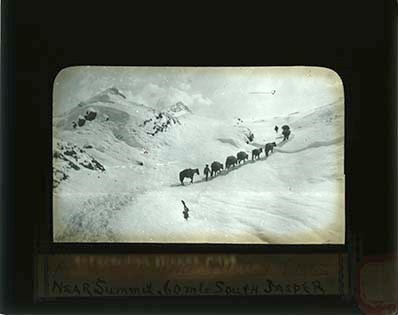
Approaching Wilcox Pass, near summit, 60 mls South Jasper
https://archives.whyte.org/en/permalink/descriptions43358
- Part Of
- Malcolm Geddes fonds
- Scope & Content
- Lantern slide depicts a pack train travelling through snow near the summit of Mount Wilcox.
- Date Range
- [ca.1913-ca.1925]
- Reference Code
- V756 / III / A / PS - 116
- Description Level
- 6 / Item
- GMD
- Photograph
- Lantern slide
1 image
- Part Of
- Malcolm Geddes fonds
- Description Level
- 6 / Item
- Fonds Number
- M39 / V756
- Series
- V756 / III : Personal and family records
- Sous-Fonds
- V756
- Accession Number
- 6504
- Reference Code
- V756 / III / A / PS - 116
- Date Range
- [ca.1913-ca.1925]
- Physical Description
- 1 photograph : b&w transparency (lantern slide)
- Scope & Content
- Lantern slide depicts a pack train travelling through snow near the summit of Mount Wilcox.
- Access Restrictions
- Fragile- restrictions may apply
- Reproduction Restrictions
- Fragile- restrictions may apply
- Language
- N/A
- Title Source
- Title based on contents of file
- Processing Status
- Processed
Images
This material is presented as originally created; it may contain outdated cultural descriptions and
potentially offensive content.
Read more.
(Athabaska River area) - junction with Snarling River
https://archives.whyte.org/en/permalink/catalogue24502
- Medium
- Library - Maps and blueprints (unannotated; published)
- Map
- Published Date
- February 24, 1911
- Publisher
- Department of the Interior
- Call Number
- C9-7.46
- Publisher
- Department of the Interior
- Published Date
- February 24, 1911
- Physical Description
- 1 map : black and white
- Scale
- 40 chains: 1 inch
- Accession Number
- SG7500
- Call Number
- C9-7.46
- Collection
- Archives Library
This material is presented as originally created; it may contain outdated cultural descriptions and
potentially offensive content.
Read more.
(Athabaska River-Talbot Lake area)
https://archives.whyte.org/en/permalink/catalogue24508
- Medium
- Library - Maps and blueprints (unannotated; published)
- Map
- Published Date
- October 19, 1911
- Publisher
- Department of the Interior
- Call Number
- C9-7.48
- Publisher
- Department of the Interior
- Published Date
- October 19, 1911
- Physical Description
- 1 map : black and white
- Scale
- 40 chains: 1 inch
- Accession Number
- SG7500
- Call Number
- C9-7.48
- Collection
- Archives Library
This material is presented as originally created; it may contain outdated cultural descriptions and
potentially offensive content.
Read more.
[Banff - Plan of resurvey of the town of Banff]
https://archives.whyte.org/en/permalink/catalogue23262
- Medium
- Library - Maps and blueprints (unannotated; published)
- Map
- Published Date
- 1914
- Publisher
- Dept. of the Interior
- Call Number
- C4-1.8
- Publisher
- Dept. of the Interior
- Published Date
- 1914
- Scale
- Scale: 1 inch = 150 ft.
- Notes
- Black and white
- Accession Number
- 718
- 2933 deaccessioned
- Call Number
- C4-1.8
- Collection
- Archives Library
This material is presented as originally created; it may contain outdated cultural descriptions and
potentially offensive content.
Read more.
[Banff - Proposed Electric Lighting Project]
https://archives.whyte.org/en/permalink/catalogue23257
- Medium
- Library - Maps and blueprints (unannotated; published)
- Map
- Published Date
- 1912
- Publisher
- Dept. of the Interior
- Call Number
- C4-1.4
- Publisher
- Dept. of the Interior
- Published Date
- 1912
- Physical Description
- 1 map : black and white
- Scale
- Scale: 400' = 1"
- Notes
- Photostatic copy from Public Archives
- Accession Number
- 675
- Call Number
- C4-1.4
- Collection
- Archives Library
This material is presented as originally created; it may contain outdated cultural descriptions and
potentially offensive content.
Read more.
[Banff - Townsite]
https://archives.whyte.org/en/permalink/catalogue21316
- Medium
- Library - Maps and blueprints (unannotated; published)
- Map
- Published Date
- 1912
- Call Number
- C4-1.13
- Published Date
- 1912
- Subjects
- Banff townsite
- Notes
- Black and white
- DAMAGED
- Accession Number
- 1113
- Call Number
- C4-1.13
- Collection
- Archives Library
This material is presented as originally created; it may contain outdated cultural descriptions and
potentially offensive content.
Read more.
[Banff: Bow River to Moose Street]
https://archives.whyte.org/en/permalink/catalogue23258
- Medium
- Library - Maps and blueprints (unannotated; published)
- Map
- Published Date
- 1913
- Author
- Walker, C.M.
- Publisher
- Ottawa: Dept. of the Interior
- Call Number
- C4-1.4
- Author
- Walker, C.M.
- Publisher
- Ottawa: Dept. of the Interior
- Published Date
- 1913
- Physical Description
- 1 map : black and white
- Scale
- Scale indeterminable
- Subjects
- Banff - Townsite development
- Walker, C.M.
- Notes
- Compiled from official surveys, December 17, 1912, by C.M. Walker
- Accession Number
- 5670
- Call Number
- C4-1.4
- Collection
- Archives Library
This material is presented as originally created; it may contain outdated cultural descriptions and
potentially offensive content.
Read more.
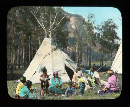
Banff Indian Days [Stoney Nakoda camp at foot of Cascade Mountain]
https://archives.whyte.org/en/permalink/descriptions38672
- Part Of
- Mary Schaffer fonds
- Date Range
- [ca. 1900 - 192-]
- Reference Code
- V527 / PS 1 - 683
- Description Level
- 6 / Item
- GMD
- Photograph
- Lantern slide
- Transparency
1 image
- Part Of
- Mary Schaffer fonds
- Description Level
- 6 / Item
- Fonds Number
- M79 / V527
- Series
- II. Photography series
- Sous-Fonds
- V527
- Sub-Series
- A. Lantern slides 8. Native people
- Reference Code
- V527 / PS 1 - 683
- Date Range
- [ca. 1900 - 192-]
- Physical Description
- 1 transparency : lantern slide
- Subject Access
- Buildings and memorials
- Environment and Nature
- First nations
- Public events
- Geographic Access
- Alberta
- Title Source
- Title based on contents of file
- Processing Status
- Processed
Images
This material is presented as originally created; it may contain outdated cultural descriptions and
potentially offensive content.
Read more.
- Part Of
- Mary Schaffer fonds
- Scope & Content
- Transparencies are hand-coloured and black and white lantern slides pertaining to bison, bison hunting and the decline of bison. Mainly illustrations, 1860s-1880s
- Date Range
- [ca.1910]
- Reference Code
- V527 / PS 1 - 639 to 668
- Description Level
- 5 / File
- GMD
- Photograph
- Lantern slide
- Transparency
- Part Of
- Mary Schaffer fonds
- Description Level
- 5 / File
- Fonds Number
- M79 / V527
- Series
- II.A. Photographs: lantern slides
- Sous-Fonds
- V527
- Reference Code
- V527 / PS 1 - 639 to 668
- Date Range
- [ca.1910]
- Physical Description
- 30 photographs : transparencies; glass
- Scope & Content
- Transparencies are hand-coloured and black and white lantern slides pertaining to bison, bison hunting and the decline of bison. Mainly illustrations, 1860s-1880s
- Finding Aid
- Copy prints are available for reference use
- Location (Copy)
- Reference prints are available
- Title Source
- Title based on contents of file
- Content Details
- LIST OF LANTERN SLIDES - V527 / PS 1 :
- #639 - [Pile of buffalo bones]
- #640, 641 - [Illustration – Indigenous people hunting buffalo] (641)
- #642 - [Illustration] Indigenous people on Snowshoes hunting Buffaloes
- #643 - [Illustration – Indigenous people driving buffalo over buffalo jump]
- #644 - [Illustration] Driving Buffalo over a cliff
- #645 - [Indigenous woman stretching buffalo hide]
- #646 - [Indigenous woman with horse pulling travois]
- #647 - [Illustration] Cree Indigenous people impounding the buffalo
- #648 - [Illustration] The Herd, 1860 (648)
- #650 - [Illustration – Indigenous people hunting buffalo]
- #651 - [Illustration] The End, 1883
- #652 - Buffalo Bones In 1875
- #653, 654 - [Illustration - early depiction of buffalo]
- #655 - [Illustration] Buffalo - a hold up 1869
- #656 - [Loading buffalo bones onto railway cars]
- #657 - [Buffalo bones piled beside railway cars]
- #658 - [Illustration - hunter shooting buffalo]
- #659 - Buffalo Trail Buffalo National Park
- #660 - [Buffalo swimming river]
- #661 - Buffalo wallowing
- #662 - Buffalo starting to wallow
- #663 - Buffalo wallow
- #664 - Buffalo, Banff National Park
- #665 - [Illustration – Indigenous people hunting buffalo]
- #666 - [Illustration] Hunting disguised as wolves
- #667 - [Painted buffalo hide]
- #668 - [Illustration - Indigenous moccasins & carry bags]
- Processing Status
- Processed
This material is presented as originally created; it may contain outdated cultural descriptions and
potentially offensive content.
Read more.
[Boundary Between Alberta and B.C.]
https://archives.whyte.org/en/permalink/catalogue24662
- Medium
- Library - Maps and blueprints (unannotated; published)
- Map
- Published Date
- 1916
- Edition
- Sheet #12
- Call Number
- C3-9.13
- Edition
- Sheet #12
- Published Date
- 1916
- Scale
- Scale: 1:62,500
- Relief: Contour interval 100 ft.
- Series
- Sheet #12
- Notes
- 2 duplicates in Map Room
- 2 photostat copies showing outline of Mt. Assiniboine Provincial Park
- Duplicate in Boundary Atlas #1
- Accession Number
- 44
- 400
- 3349
- 2949
- Call Number
- C3-9.13
- Collection
- Archives Library
This material is presented as originally created; it may contain outdated cultural descriptions and
potentially offensive content.
Read more.