Narrow Results By
Mountaineering Scrapbook
https://archives.whyte.org/en/permalink/descriptions25631
- Part Of
- Herbert E. Sampson fonds
- Scope & Content
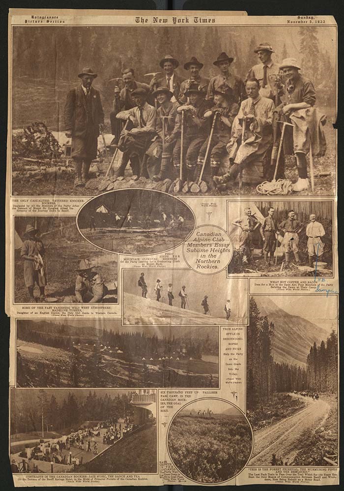
- File pertains to scrapbook containing news clippings and memorabilia related to mountaineering in the Canadian Rocky Mountains and the Alps.
- Date Range
- 1927-1939
- Reference Code
- M76
- Description Level
- 5 / File
- GMD
- Scrapbook
1 image
1 Electronic Resource
- Part Of
- Herbert E. Sampson fonds
- Description Level
- 5 / File
- Fonds Number
- M76 / V174
- Sous-Fonds
- M76
- Accession Number
- 496
- Reference Code
- M76
- GMD
- Scrapbook
- Date Range
- 1927-1939
- Physical Description
- 1 cm of textual records (22 pages ; 27 x 35.5 cm)
- History / Biographical
- See fonds level description.
- Scope & Content
- File pertains to scrapbook containing news clippings and memorabilia related to mountaineering in the Canadian Rocky Mountains and the Alps.
- Subject Access
- Alpine Club of Canada
- Avalanches
- Backcountry skiing
- Backpacking
- Bears
- Climbing
- Environment and Nature
- Exploration
- Mountaineering
- Mountaineers
- Newspaper
- Geographic Access
- Banff
- Banff National Park
- Jasper
- Tonquin Valley
- Mount Lefroy
- Mount Logan
- Matterhorn
- Himalayas
- Jasper National Park
- Alberta
- Canada
- Language
- English
- Title Source
- Title based on contents of file.
- Processing Status
- Processed
Electronic Resources
Images
This material is presented as originally created; it may contain outdated cultural descriptions and
potentially offensive content.
Read more.
- Part Of
- Bert Riggall fonds
- Scope & Content
- File consists of 35 b&w, some captioned. The prints pertain to various views of mountains South Western Alberta, South Eastern British Columbia, and Montana. Views include Red Eagle, Little Chief, Citadel peaks, Heaven's peak, Reynold's peak, mount Canon, Logan's pass, Chief Mountain, and Wall Lak…
- Date Range
- 1912 to 1945
- Reference Code
- V26 / III / B17 / PA - 1 to 35
- Description Level
- 5 / File
- Part Of
- Bert Riggall fonds
- Description Level
- 5 / File
- Series
- III. Professional Photography: Topical Files
- Reference Code
- V26 / III / B17 / PA - 1 to 35
- Date Range
- 1912 to 1945
- Physical Description
- Photographs: 35 prints, b&w
- Scope & Content
- File consists of 35 b&w, some captioned. The prints pertain to various views of mountains South Western Alberta, South Eastern British Columbia, and Montana. Views include Red Eagle, Little Chief, Citadel peaks, Heaven's peak, Reynold's peak, mount Canon, Logan's pass, Chief Mountain, and Wall Lake.
- Subject Access
- Mountains
- Title Source
- Title based on contents of file
- Content Details
- This subseries contains 618 prints. They are not individually numbered.
- Processing Status
- Processed
This material is presented as originally created; it may contain outdated cultural descriptions and
potentially offensive content.
Read more.
Maps of the northern Montana to northern Rocky Mountains area
https://archives.whyte.org/en/permalink/descriptions16611
- Part Of
- Bert Riggall fonds
- Scope & Content
- Cartographic materials are holograph maps and annotated published maps concerning the area from northern Montana to the northern Rocky Mountains. Features marked on maps may include ranch properties, trails, routes, camps, game, local names, elevations, hunting and special licence areas, revised p…
- Date Range
- 1928-1943
- Reference Code
- M376 / 87, 88
- Description Level
- 5 / File
- Part Of
- Bert Riggall fonds
- Description Level
- 5 / File
- Series
- II. Business and financial series
- Reference Code
- M376 / 87, 88
- Date Range
- 1928-1943
- Physical Description
- ca.15 cartographic records
- Scope & Content
- Cartographic materials are holograph maps and annotated published maps concerning the area from northern Montana to the northern Rocky Mountains. Features marked on maps may include ranch properties, trails, routes, camps, game, local names, elevations, hunting and special licence areas, revised park boundaries, other
- Creator
- File includes undated maps
- Title Source
- Title based on contents of file
- Content Details
- LIST OF ITEMS :
- * Laurier Pass country. -- [ca.1930]. -- 4 cartographic records. -- Letters transferred to correspondence series (M376/87)
- * Halfway River / Department of the Interior, Surveyor General, Ottawa. -- 1928 April. -- Scale 4 miles : inch (M376/87)
- * Prophet River, British Columbia / Department of the Interior, Surveyor General, Ottawa. -- 1928 April. -- Scale 4 miles : inch (M376/87)
- * Report of an exploratory trip in the area covered by Halfway River and Prophet River, sheets of the National Topographic Series in the Province of British Columbia. -- 1928. -- [ n.s.]. By McCuster, K.F., D.L.S., F.A. Ackland, Printer. Ottawa (M376/87)
- * Hudson Hope British Columbia / Department of the Interior, Surveyor General, Ottawa. -- 1929 February. -- Scale 8 miles : inch (M376/87)
- * Hand-drawn map. -- [n.d.]. -- Map of the area located north-east of Jasper Park boundary on a fork of the Hay River, northwest of Solomon Creek, showing game locations of caribou and sheep. Map is drawn on reverse of published map: Jasper Park in the Province of Alberta (M376/88)
- * Hand-drawn map. -- [n.d.] -- Map of sheep hunting territory north of Jasper Park boundary, near Hay River (M376/88)
- * Jasper Park, Alberta, Mount Robson, British Columbia, Canadian Rocky Mountains, Grand Trunk Pacific Railway / compiled in part from the Topographical Surveys by the Alpine Club of Canada. -- [n.d.]. -- Annotation reads: Indicates route Bert Riggall took on his 1911 trip, trails and stops marked. Scale: 5 miles to an inch (M376/88)
- * Province of Alberta, Canada / Department of Lands of Mine, Canada. -- 1941. -- Annotated, showing areas near Clearwater River and north of Jasper as "special license". Scale 16 miles : inch (M376/88)
- * Midnapore, Alberta showing (C.W. Peterson's Ranch) Craighurst Farm / Department of Mines and Resources, Canada. -- 1940. -- Annotation shows 1904 location of ranch. Scale 1 : 63,360 or 1 mile : inch (M376/88)
- * Mundy's pocket map of northwest Canada and part of Alaska / Mundy Map Co., Edmonton, Alberta. -- 1943. -- Resources map annotated with highlight of Mt. Logan area. Scale 62 miles : inch (M376/88)
- Laurier Pass country. -- [ca.1930]. -- 4 cartographic records. -- Letters transferred to correspondence series
- Part of file: Maps of the northern Montana to northern Rocky Mountains area Halfway River / Department of the Interior, Surveyor General, Ottawa. -- 1928 April. -- Scale 4 miles : inch
- Part of file: Maps of the northern Montana to northern Rocky Mountains area Prophet River, British Columbia / Department of the Interior, Surveyor General, Ottawa. -- 1928 April. -- Scale 4 miles : inch
- Part of file: Maps of the northern Montana to northern Rocky Mountains area Report of an exploratory trip in the area covered by Halfway River and Prophet River, sheets of the National Topographic Series in the Province of British Columbia. -- 1928. -- [ n.s.]. By McCuster, K.F., D.L.S., F.A. Ackland, Printer. Ottawa
- Part of file: Maps of the northern Montana to northern Rocky Mountains area Hudson Hope British Columbia / Department of the Interior, Surveyor General, Ottawa. -- 1929 February. -- Scale 8 miles : inch
- Part of file: Maps of the northern Montana to northern Rocky Mountains area Hand-drawn map. -- [n.d.]. -- Map of the area located north-east of Jasper Park boundary on a fork of the Hay River, northwest of Solomon Creek, showing game locations of caribou and sheep. Map is drawn on reverse of published map: Jasper Park in the Province of Alberta
- Part of file: Maps of the northern Montana to northern Rocky Mountains area Hand-drawn map. -- [n.d.] -- Map of sheep hunting territory north of Jasper Park boundary, near Hay River
- Part of file: Maps of the northern Montana to northern Rocky Mountains area Jasper Park, Alberta, Mount Robson, British Columbia, Canadian Rocky Mountains, Grand Trunk Pacific Railway / compiled in part from the Topographical Surveys by the Alpine Club of Canada. -- [n.d.]. -- Annotation reads: Indicates route Bert Riggall took on his 1911 trip, trails and stops marked. Scale: 5 miles to an inch
- Part of file: Maps of the northern Montana to northern Rocky Mountains area Province of Alberta, Canada / Department of Lands of Mine, Canada. -- 1941. -- Annotated, showing areas near Clearwater River and north of Jasper as "special license". Scale 16 miles : inch
- Part of file: Maps of the northern Montana to northern Rocky Mountains area Midnapore, Alberta showing (C.W. Peterson's Ranch) Craighurst Farm / Department of Mines and Resources, Canada. -- 1940. -- Annotation shows 1904 location of ranch. Scale 1 : 63,360 or 1 mile : inch
- Part of file: Maps of the northern Montana to northern Rocky Mountains area Mundy's pocket map of northwest Canada and part of Alaska / Mundy Map Co., Edmonton, Alberta. -- 1943. -- Resources map annotated with highlight of Mt. Logan area. Scale 62 miles : inch
- Part of file: Maps of the northern Montana to northern Rocky Mountains area Maps held in oversize "F"
This material is presented as originally created; it may contain outdated cultural descriptions and
potentially offensive content.
Read more.