Narrow Results By
- Part Of
- Murray Hay fonds
- Scope & Content
- File consists of 144 photographs : col. negatives ; 35 m m; 12 prints : col. ; 42 x 35 cm or smaller ; 1 cm of visual material. File pertains to various projects Murray Hay was involved with related to Alaska, USA, particularly in the mid-1990s. File includes: aerial photographs of the landscape (A…
- Date Range
- ca.1990-ca.1999
- 1992
- 1994
- Reference Code
- V795 / II / D / i / 1-2
- Description Level
- 5 / File
- GMD
- Drawing
- Map
- Photograph print
- Negative
- Private record
- Textual record
- Part Of
- Murray Hay fonds
- Description Level
- 5 / File
- Fonds Number
- M570 / V795
- Series
- V795 / II : Unpublished Material
- Sous-Fonds
- V795
- Sub-Series
- V795 / II / D : International / i : United States of America
- Accession Number
- 2019.41
- Reference Code
- V795 / II / D / i / 1-2
- Date Range
- ca.1990-ca.1999
- 1992
- 1994
- Physical Description
- 144 photographs : col. negatives ; 35 mm
- 12 prints : col. ; 42 x 35 cm or smaller
- 1 cm of visual material
- Scope & Content
- File consists of 144 photographs : col. negatives ; 35 m m; 12 prints : col. ; 42 x 35 cm or smaller ; 1 cm of visual material. File pertains to various projects Murray Hay was involved with related to Alaska, USA, particularly in the mid-1990s. File includes: aerial photographs of the landscape (Anchorage area, Homer, Prince William Sound, Valdez); hand-drawn draft maps of the Prince William Sound region (created for a cruise line); a variety of printed maps with annotations demonstrating comments (including a fax with an attached map from Dana at Adventure Media International); and a variety of printed reproductions of draft maps (Alyeska Ski Resort, City of Anchorage for the 1992 Olympic Bid, and Glacier Bay and the Tongass National Forest).
- Notes
- Items not in oversize (negatives) stored in downstairs vault.
- Name Access
- Hay, Murray
- Subject Access
- Advertising
- Artist
- Ski Maps
- Map
- Cartography
- Sports and recreation
- Tourism
- Tourist information
- Travel
- Geography
- Winter
- Winter sports
- Ski area
- Olympic Games (Winter)
- Geographic Access
- Alaska
- United States
- Valdez
- Prince William Sound
- Anchorage
- Glacier Bay and Tongass National Forest
- Language
- English
- Conservation
- Masking tape should be removed and alternative preservation methods used in the future.
- Related Material
- M570 / IV / A / 2-3
- Creator
- Hay, Murray
- Title Source
- Title based on contents of file
- Processing Status
- Processed
This material is presented as originally created; it may contain outdated cultural descriptions and
potentially offensive content.
Read more.
- Part Of
- Murray Hay fonds
- Scope & Content
- File consists of 1 map : col., annotations, 96.5 x 69 cm. File pertains to an original unfinished hand-drawn map of interior Arizona in red, blue, black, and purple ink. Includes geographic features and labeled cities (including Yuma, Nogales, Bisbee, and Flagstaff).
- Date Range
- ca.1990-ca.1999
- Reference Code
- V795 / II / D / i / 4
- Description Level
- 5 / File
- GMD
- Drawing
- Map
- Private record
- Textual record
- Part Of
- Murray Hay fonds
- Description Level
- 5 / File
- Fonds Number
- M570 / V795
- Series
- V795 / II : Unpublished Material
- Sous-Fonds
- V795
- Sub-Series
- V795 / II / D : International / i : United States of America
- Accession Number
- 2019.41
- Reference Code
- V795 / II / D / i / 4
- Date Range
- ca.1990-ca.1999
- Physical Description
- 1 map : col., annotations ; 96.5 x 69 cm
- Scope & Content
- File consists of 1 map : col., annotations, 96.5 x 69 cm. File pertains to an original unfinished hand-drawn map of interior Arizona in red, blue, black, and purple ink. Includes geographic features and labeled cities (including Yuma, Nogales, Bisbee, and Flagstaff).
- Name Access
- Hay, Murray
- Subject Access
- Advertising
- Artist
- Ski Maps
- Map
- Cartography
- Sports and recreation
- Tourism
- Tourist information
- Travel
- Geography
- Winter
- Winter sports
- Ski area
- Geographic Access
- Arizona
- United States
- Language
- English
- Creator
- Hay, Murray
- Title Source
- Title based on contents of file
- Processing Status
- Processed
This material is presented as originally created; it may contain outdated cultural descriptions and
potentially offensive content.
Read more.
Baja California Sur, Mexico
https://archives.whyte.org/en/permalink/descriptions54974
- Part Of
- Murray Hay fonds
- Scope & Content
- File consists of 11 maps : mss. and reproductions, some col., annotations ; 43 x 94 cm or smaller. File pertains to a project Murray Hay worked on for Glacier Bay Tours and Cruises (based out of Alaska). File includes 11 original hand-drawn and reproduced drafts, including annotations, of a map dep…
- Date Range
- ca.1990-ca.1999
- ca. 1998
- Reference Code
- V795 / II / D / ii / 2-3
- Description Level
- 5 / File
- GMD
- Drawing
- Map
- Private record
- Part Of
- Murray Hay fonds
- Description Level
- 5 / File
- Fonds Number
- M570 / V795
- Series
- V795 / II : Unpublished Material
- Sous-Fonds
- V795
- Sub-Series
- V795 / II / D : International / ii : Miscellaneous
- Accession Number
- 2019.41
- Reference Code
- V795 / II / D / ii / 2-3
- GMD
- Drawing
- Map
- Private record
- Date Range
- ca.1990-ca.1999
- ca. 1998
- Physical Description
- 11 maps : mss. and reproductions, some col., annotations ; 43 x 94 cm or smaller
- Scope & Content
- File consists of 11 maps : mss. and reproductions, some col., annotations ; 43 x 94 cm or smaller. File pertains to a project Murray Hay worked on for Glacier Bay Tours and Cruises (based out of Alaska). File includes 11 original hand-drawn and reproduced drafts, including annotations, of a map depicting the Baja California Sur region and the cruise's route in this area.
- Notes
- Originally filed with correspondence related to this project [see related material]. "For Steve Cowart" is also written on at least one map (who Murray Hay is corresponding with in M570 / IV / A / 1). Items not in oversize stored in downstairs vault.
- Name Access
- Hay, Murray
- Cowart, Steve
- Subject Access
- Advertising
- Artist
- Cartography
- Map
- Tourism
- Tourist information
- Travel
- Geography
- Geographic Access
- Mexico
- Baja California Sur
- Language
- English
- Related Material
- M570 / IV / A /1
- Creator
- Hay, Murray
- Title Source
- Title based on contents of file
- Processing Status
- Processed
This material is presented as originally created; it may contain outdated cultural descriptions and
potentially offensive content.
Read more.
Ben Gadd fonds
https://archives.whyte.org/en/permalink/descriptions55758
- Part Of
- Ben Gadd fonds
- Scope & Content
- Fonds consists of materials pertaining to Ben Gadd's personal life and career as an environmental researcher, educator, interpretive guide, publisher, public speaker and author, ca.1956-2018. Fonds includes maps, research materials, publication notes/drafts, correspondence, contracts, photographs, …
- Date Range
- 1956-2018
- Reference Code
- M590 / V810 / S61
- Description Level
- 1 / Fonds
- GMD
- Digital image
- Drawing
- Negative
- Newspaper clipping
- Photograph
- Photograph print
- Postcard
- Published record
- Textual record
- Video
- Transparency
- Part Of
- Ben Gadd fonds
- Description Level
- 1 / Fonds
- Fonds Number
- M590
- V810
- Sous-Fonds
- M590
- V810
- Accession Number
- 2021.20
- 2024.01
- Reference Code
- M590 / V810 / S61
- GMD
- Digital image
- Drawing
- Negative
- Newspaper clipping
- Photograph
- Photograph print
- Postcard
- Published record
- Textual record
- Video
- Transparency
- Date Range
- 1956-2018
- Physical Description
- ca. 7.9 metres of textual records -- ca. 274 maps -- 29 VHS tapes -- ca.15 discs with digital files -- 21 cassettes -- photographs -- oversized materials -- USB stick with 15 sldeshows
- History / Biographical
- Ben Gadd (1946-) is a retired naturalist, guide, geologist, instructor, freelance writer and award-winning author based in the Canadian Rockies. Ben was born in Colorado Springs, Colorado in 1946. He met his wife, Cia (Langdon) Gadd at Colorado College in 1965, and the couple married four weeks later. Ben and Cia had two sons, Will and Toby. Ben and his family relocated to Jasper in the late 1960s. Ben later attended the University of Lethbridge and graduated with a Bachelor's degree in Earth Science in 1972. Between 1976 and 1980, Ben taught classes at Mount Royal College and the Southern Alberta Institute of Technology; he later taught additional classes at Grant MacEwan College and Lakeland College. From 1981, Ben also worked as a seasonal naturalist/guide for Parks Canada. Ben left Parks Canada in 1985 to start an independent naturalist guiding business with Cia based in Jasper and other parts of the Canadian Rockies, which the couple continued to operate for over two decades. Ben published his best-known work, "Handbook of the Canadian Rockies", through his publishing company Corax Press in 1986. The second edition of "Handbook of the Canadian Rockies" received multiple awards after its release in 1995. Ben's fiction book, "Raven's End" won the title of Best Canadian Rockies Book at the Banff Mountain Film and Book Festival in 2001 and became a Canadian bestseller. Overall, Ben has authored or co-authored 11 books and received nearly one dozen awards for his achievements as a writer, researcher and guide. Ben continued to lead guided hikes and school programs until his retirement in 2016.
- Scope & Content
- Fonds consists of materials pertaining to Ben Gadd's personal life and career as an environmental researcher, educator, interpretive guide, publisher, public speaker and author, ca.1956-2018. Fonds includes maps, research materials, publication notes/drafts, correspondence, contracts, photographs, video and sound recordings, and other related material. Materials donated in 2024 include one USB stick containing
- Notes
- Ben Gadd fonds arrangement: Series I : Personal records - Subseries A : Travel guides and maps - Subseries B : Education and early writings - Subseries C : Personal interest files - Subseries D : Other personal and collected Series II : Research and publication records - Subseries A : Handbook of the Canadian Rockies - Subseries B : Other publications Series III : Professional records - Subseries A : Parks Canada Records - Subseries B : Interpretive guiding - Subseries C : Teaching records - Subseries D : Other contracts and projects Series IV : Legal and financial records - Subseries A : Legal records - Subseries B : Financial records
- Subject Access
- Education
- Research
- Publication
- Environment
- Geology
- Tourism
- Family and personal life
- Personal and Professional Life
- Academics
- Guiding
- Guides
- Businesses
- Finances
- Conservation
- Wildlife
- Natural history
- Sports and recreation
- Geographic Access
- Canada
- Alberta
- Jasper National Park
- Banff National Park
- Yoho National Park
- Kootenay National Park
- Lethbridge
- United States of America
- Colorado
- Canadian Rocky Mountains
- Reproduction Restrictions
- Copyright restrictions apply
- Language
- English
- French
- Dutch
- Title Source
- Title based on contents of fonds
- Processing Status
- Processed / Unprocessed
This material is presented as originally created; it may contain outdated cultural descriptions and
potentially offensive content.
Read more.
Freelance and loose writing, comics
https://archives.whyte.org/en/permalink/descriptions54486
- Scope & Content
- File consists of textual records pertaining to trips led by the Trail Riders of the Canadian Rockies. Includes an annotated skit performed on a 1982 trail ride, drafts of possible content for newsletters, freelance writing samples, and accounts of specific trail rides. Most items list author(s) and…
- Date Range
- [1970-1980]
- 1982-1984
- 1986
- 1992-1993
- 1999
- 2003
- 2005-2008
- Reference Code
- M545 / II / 19
- Description Level
- 5 / File
- GMD
- Textual record
- Private record
- Drawing
- Description Level
- 5 / File
- Fonds Number
- M545 / V635
- Series
- M545 / II : Members, Staff and Personal Records
- Sous-Fonds
- M545
- Accession Number
- 8235
- Reference Code
- M545 / II / 19
- Date Range
- [1970-1980]
- 1982-1984
- 1986
- 1992-1993
- 1999
- 2003
- 2005-2008
- Physical Description
- 2 cm of textual records
- Scope & Content
- File consists of textual records pertaining to trips led by the Trail Riders of the Canadian Rockies. Includes an annotated skit performed on a 1982 trail ride, drafts of possible content for newsletters, freelance writing samples, and accounts of specific trail rides. Most items list author(s) and date. File also includes several annotated sketches depicting trail riders.
- Notes
- File contains duplicates which have been attached to each other
- Name Access
- Fedder, Zelda
- Vale, Don
- Howard, Christine
- Sharp, Thelma
- Levy, Joanne
- Brown, Brenda
- Bauer, Rebecca
- Orr, Dennis
- Wallace, Don
- Reid, Janice
- Elphinstone, Michelle
- Dallimore, Karen
- Godderis, Rick
- Geographic Access
- Canada
- Alberta
- Banff
- Clearwater
- Wonder Pass
- Language
- English
- Conservation
- Metal staples removed from numerous items
- Category
- Sports, recreation and leisure
- Title Source
- Title based on contents of file
- Processing Status
- Processed
This material is presented as originally created; it may contain outdated cultural descriptions and
potentially offensive content.
Read more.
Green Valley, Kananaskis Country
https://archives.whyte.org/en/permalink/artifactmip.03.03
- Date
- 1994
- Medium
- oil pastel on acid free board
- Catalogue Number
- MiP.03.03
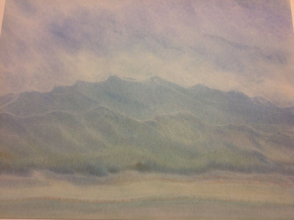
- Description
- This pastel drawing has different colours of green in the foreground. There is a row of dark green trees separating the valley from the base of the mountains. In the middle section there are two layers of mountains. The lower mountain has a green colour and the higher layer of mountains are blue. T…
1 image
- Title
- Green Valley, Kananaskis Country
- Date
- 1994
- Medium
- oil pastel on acid free board
- Description
- This pastel drawing has different colours of green in the foreground. There is a row of dark green trees separating the valley from the base of the mountains. In the middle section there are two layers of mountains. The lower mountain has a green colour and the higher layer of mountains are blue. The sky is light blue with some thin white clouds.
- Subject
- landscape
- Canadian Rockies
- Kananaskis
- Credit
- Gift of Phil Michaud, Banff, 1997
- Catalogue Number
- MiP.03.03
Images
This material is presented as originally created; it may contain outdated cultural descriptions and
potentially offensive content.
Read more.
Icefield Series – A
https://archives.whyte.org/en/permalink/artifactmib.03.01
- Date
- 1993
- Medium
- charcoal; chalk on paper
- Catalogue Number
- MiB.03.01
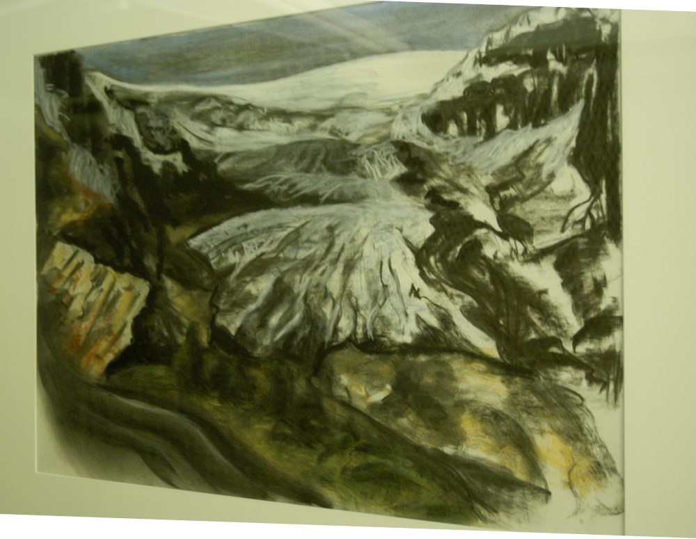
- Description
- Icefield fans out from centre near top to the foreground. Mountain frames the foreground and both sides with shades of green, yellow and brown. Blue sky has long dark streaks.
1 image
- Title
- Icefield Series – A
- Date
- 1993
- Medium
- charcoal; chalk on paper
- Dimensions
- 52.5 x 72.4 cm
- Description
- Icefield fans out from centre near top to the foreground. Mountain frames the foreground and both sides with shades of green, yellow and brown. Blue sky has long dark streaks.
- Credit
- Gift of Barbara Milne, Calgary, 1994
- Catalogue Number
- MiB.03.01
Images
This material is presented as originally created; it may contain outdated cultural descriptions and
potentially offensive content.
Read more.
Icefield Series – B
https://archives.whyte.org/en/permalink/artifactmib.03.02
- Date
- 1993
- Medium
- charcoal; chalk on paper
- Catalogue Number
- MiB.03.02
- Description
- Mountain dominates almost full frame, icefield centred top, foreground dark with hint of colours green and brown. Sky blue with tinge of green.
1 image
- Title
- Icefield Series – B
- Date
- 1993
- Medium
- charcoal; chalk on paper
- Dimensions
- 52.5 x 72.4 cm
- Description
- Mountain dominates almost full frame, icefield centred top, foreground dark with hint of colours green and brown. Sky blue with tinge of green.
- Credit
- Gift of Barbara Milne, Calgary, 1994
- Catalogue Number
- MiB.03.02
Images
This material is presented as originally created; it may contain outdated cultural descriptions and
potentially offensive content.
Read more.
Icefield Series - C
https://archives.whyte.org/en/permalink/artifactmib.03.03
- Date
- 1993
- Medium
- charcoal; chalk on paper
- Catalogue Number
- MiB.03.03
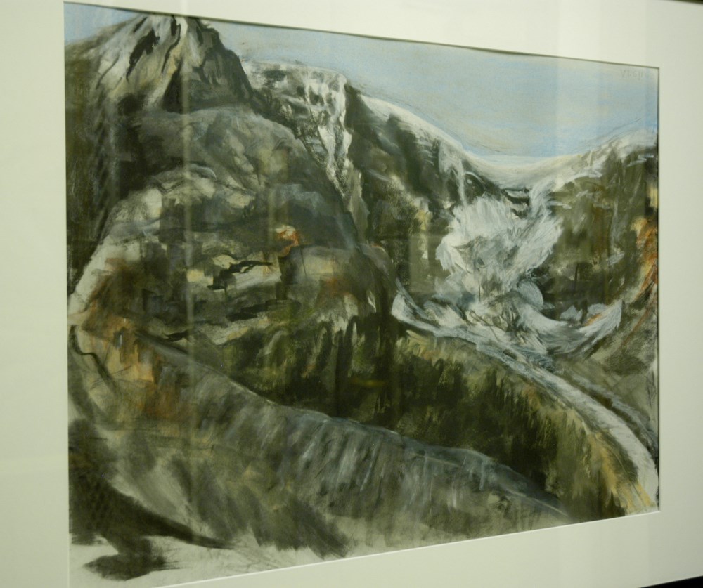
- Description
- The mountain dominates to almost top of picture. Icefield at top right and down to right foreground. Mountain is mostly black with contours of light and dark with shades of green, brown and yellow. The sky is lightly streaked blue.
1 image
- Title
- Icefield Series - C
- Date
- 1993
- Medium
- charcoal; chalk on paper
- Dimensions
- 52.5 x 72.5 cm
- Description
- The mountain dominates to almost top of picture. Icefield at top right and down to right foreground. Mountain is mostly black with contours of light and dark with shades of green, brown and yellow. The sky is lightly streaked blue.
- Credit
- Gift of Barbara Milne, Calgary, 1994
- Catalogue Number
- MiB.03.03
Images
This material is presented as originally created; it may contain outdated cultural descriptions and
potentially offensive content.
Read more.
- Part Of
- Murray Hay fonds
- Scope & Content
- File consists of 1 map : col., annotations, 59.9 x 41.3 cm. File pertains to an original hand-drawn map of central Montana, including annotations and a note directed to a Steve from Murray in the bottom left corner. Map details include the locations of various cities in Montana (including Butte, Bo…
- Date Range
- ca.1990-ca.1999
- Reference Code
- V795 / II / D / i / 3
- Description Level
- 5 / File
- GMD
- Drawing
- Map
- Private record
- Textual record
- Part Of
- Murray Hay fonds
- Description Level
- 5 / File
- Fonds Number
- M570 / V795
- Series
- V795 / II : Unpublished Material
- Sous-Fonds
- V795
- Sub-Series
- V795 / II / D : International / i : United States of America
- Accession Number
- 2019.41
- Reference Code
- V795 / II / D / i / 3
- Date Range
- ca.1990-ca.1999
- Physical Description
- 1 map : col., annotations ; 59.9 x 41.3 cm
- Scope & Content
- File consists of 1 map : col., annotations, 59.9 x 41.3 cm. File pertains to an original hand-drawn map of central Montana, including annotations and a note directed to a Steve from Murray in the bottom left corner. Map details include the locations of various cities in Montana (including Butte, Bozeman, Billings, Great Falls, Helena, Missoula, and Kalispell), 19 different ski hills/resorts, and mountains.
- Notes
- The Steve the map is addressed to could be Steve Cowart, who Murray Hay corresponded with in regards to other American projects (see M570 / IV / A / 1).
- Name Access
- Hay, Murray
- Subject Access
- Advertising
- Artist
- Ski Maps
- Map
- Cartography
- Sports and recreation
- Tourism
- Tourist information
- Travel
- Geography
- Winter
- Winter sports
- Ski area
- Geographic Access
- Montana
- Helena
- Great Falls
- Butte
- Bozeman
- Missoula
- United States
- Language
- English
- Conservation
- Stored flat
- Creator
- Hay, Murray
- Title Source
- Title based on contents of file
- Processing Status
- Processed
This material is presented as originally created; it may contain outdated cultural descriptions and
potentially offensive content.
Read more.