Narrow Results By
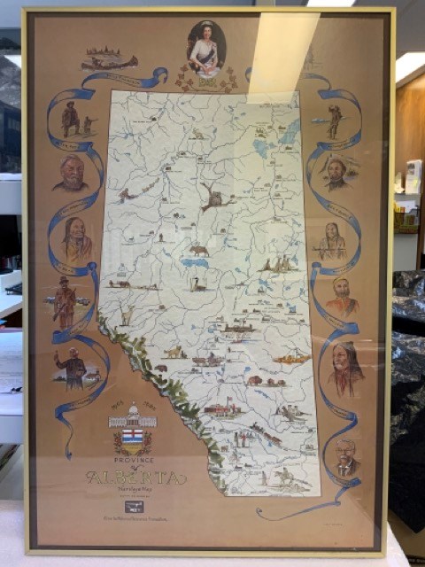
Province of Alberta Heritage Map
https://archives.whyte.org/en/permalink/artifacttuj.04.01
- Date
- 1980
- Medium
- print on paper
- Catalogue Number
- TuJ.04.01
- Description
- Off-white coloured map of alberta with blue bodies of water, green mppuntain rangte, and coloured drawings of animals, points of interest, and people. Brown background around map with blue ribbons and portraits of significant people, including Queen Elizabeth II at top. The Alberta coat of arms is …
1 image
- Title
- Province of Alberta Heritage Map
- Date
- 1980
- Medium
- print on paper
- Dimensions
- 91.0 x 96.0 cm
- Description
- Off-white coloured map of alberta with blue bodies of water, green mppuntain rangte, and coloured drawings of animals, points of interest, and people. Brown background around map with blue ribbons and portraits of significant people, including Queen Elizabeth II at top. The Alberta coat of arms is at bottom left with “1905” “1980” “PROVINCE OF ALBERTA HERITAGE MAP COMMISSIONED BY Alberta Historical Resources Foundation” Signed J.D. TURNER bottom right. In thin brass frame with glass.
- Credit
- Gift of John Davenall Turner (Estate), 2020
- Catalogue Number
- TuJ.04.01
Images
This material is presented as originally created; it may contain outdated cultural descriptions and
potentially offensive content.
Read more.
Map Drawing Book For Use in Public Schools
https://archives.whyte.org/en/permalink/artifactwyp.03.584
- Date
- c. 1914
- Medium
- graphite on paper
- Catalogue Number
- WyP.03.584
- Description
- Peter Whyte’s Map Drawing sketchbook, likely an exercise book for school, with a printed cover page and map drawings inside. Cover page reads: MAP DRAWING BOOK [across top]; FOR USE IN THE PUBLIC SCHOOLS/ THE COPP, CLARK CO., LIMITED, TORONTO [across bottom] Inside, pencil drawings include: the Gul…
1 image
- Title
- Map Drawing Book For Use in Public Schools
- Date
- c. 1914
- Medium
- graphite on paper
- Dimensions
- 24.9 x 31.0 cm
- Description
- Peter Whyte’s Map Drawing sketchbook, likely an exercise book for school, with a printed cover page and map drawings inside. Cover page reads: MAP DRAWING BOOK [across top]; FOR USE IN THE PUBLIC SCHOOLS/ THE COPP, CLARK CO., LIMITED, TORONTO [across bottom] Inside, pencil drawings include: the Gulf of St. Lawrence, the Philippine Islands, Asia and the Middle East, and Africa.
- Subject
- world
- map
- globe
- geography
- cartography
- Asia
- Middle East
- Africa
- Philippine Islands
- Gulf of St. Lawrence
- Credit
- Gift of Catharine Robb Whyte, O. C., Banff, 1975
- Catalogue Number
- WyP.03.584
Images

This material is presented as originally created; it may contain outdated cultural descriptions and
potentially offensive content.
Read more.