Topographical Map
https://archives.whyte.org/en/permalink/artifact105.02.1181
- Date
- n.d.
- Material
- plastic; paint;
- Catalogue Number
- 105.02.1181
- Description
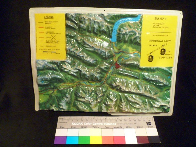
- The topographical relief map details in colour Banff and the surrounding area, including all waterways, mountain ranges and individual mountains. On the top viewer left corner there is a yellow legend that reads “LEGEND” (underlined); “CANADIAN PACIFIC RAILWAY”; “HIGHWAYS PUBLIC ROADS”; “FIRE ROADS…
1 image
- Title
- Topographical Map
- Date
- n.d.
- Material
- plastic; paint;
- Dimensions
- 2.0 x 22.0 x 30.0 cm
- Description
- The topographical relief map details in colour Banff and the surrounding area, including all waterways, mountain ranges and individual mountains. On the top viewer left corner there is a yellow legend that reads “LEGEND” (underlined); “CANADIAN PACIFIC RAILWAY”; “HIGHWAYS PUBLIC ROADS”; “FIRE ROADS NOT OPEN TO PUBLIC”; “TRAILS” (with a compass next to it); “ELEVATION IN FEET ABOVE SEA LEVEL”; “GONDOLA LIFT”; and “SCALE: 1 Inch to 3 Miles” (underneath this there is a bar scale). To the viewer left of each of the traits is the corresponding symbol indicated on the map. Perpendicular to the legend (on the viewer left) the words, “COPYRIGHT RICO FIRENZE MADE IN ITALY BREVETTO No 558142”. On the top viewer right there is another yellow box of information that reads, “BANFF”; “IN THE HEART OF THE CANADIAN ROCKIES”; a line break separates the following information: “SULPHUR MOUNTAIN” “GONDOLA LIFT” “SKYWAY TO BANFF’S TOP VIEW”. There is also a pictographic depiction of the gondola at Sulphur Mountain.
- Credit
- Gift of Nicholas Morant, Banff, 2006
- Catalogue Number
- 105.02.1181
Images
This material is presented as originally created; it may contain outdated cultural descriptions and
potentially offensive content.
Read more.
Topographical Map
https://archives.whyte.org/en/permalink/artifact105.02.1045
- Date
- 1984
- Material
- plastic
- Catalogue Number
- 105.02.1045
- Description
- Molded plastic map of Banff area. Mountains, lakes and rivers represented quite realistically, showing roads, trails, railway track, townsite, etc. Black lettering naming locations, peaks, etc. Top left corner 9.0 x 6.1 yellow flat surface with legend, top right corner 9.9 x 6.8, yellow flat surfa…
1 image
- Title
- Topographical Map
- Date
- 1984
- Material
- plastic
- Dimensions
- 22.0 x 30.0 cm
- Description
- Molded plastic map of Banff area. Mountains, lakes and rivers represented quite realistically, showing roads, trails, railway track, townsite, etc. Black lettering naming locations, peaks, etc. Top left corner 9.0 x 6.1 yellow flat surface with legend, top right corner 9.9 x 6.8, yellow flat surface with "Banff in the heart of the Canadian Rockies Sulphur Mountain Gondola Lift Skyway to Banff's Top View" with drawings of 2 gondolas.
- Credit
- Gift of Jon Whyte, Banff, 1984
- Catalogue Number
- 105.02.1045
Images

This material is presented as originally created; it may contain outdated cultural descriptions and
potentially offensive content.
Read more.