Narrow Results By
[Alberta Air Facilities Map]
https://archives.whyte.org/en/permalink/catalogue24802
- Medium
- Library - Maps and blueprints (unannotated; published)
- Map
- Published Date
- 1970
- Publisher
- Department of Lands and Forests
- Call Number
- C12-4.19
- Publisher
- Department of Lands and Forests
- Published Date
- 1970
- Scale
- 1 inch = 16 miles
- Subjects
- Alberta Air Facilities Map
- Accession Number
- 2000
- Call Number
- C12-4.19
- Collection
- Archives Library
This material is presented as originally created; it may contain outdated cultural descriptions and
potentially offensive content.
Read more.
- Medium
- Library - Maps and blueprints (unannotated; published)
- Map
- Published Date
- 1968
- Publisher
- Glaciology Subdivision, Inland Waters Branch, Department of Energy, Mines and Resources, Ottawa, Canada
- Call Number
- C5-3.6
- Publisher
- Glaciology Subdivision, Inland Waters Branch, Department of Energy, Mines and Resources, Ottawa, Canada
- Published Date
- 1968
- Physical Description
- Coloured
- Scale
- 1:1,000,000
- Accession Number
- 7000
- Call Number
- C5-3.6
- Collection
- Archives Library
This material is presented as originally created; it may contain outdated cultural descriptions and
potentially offensive content.
Read more.
- Medium
- Library - Maps and blueprints (unannotated; published)
- Map
- Published Date
- 1968
- Publisher
- Glaciology Subdivision, Inland Waters Branch, Deparment of Energy, Mines and Resources
- Call Number
- C5-3.7
- Publisher
- Glaciology Subdivision, Inland Waters Branch, Deparment of Energy, Mines and Resources
- Published Date
- 1968
- Physical Description
- Coloured
- Scale
- 1:1,000,000
- Accession Number
- 7000
- Call Number
- C5-3.7
- Collection
- Archives Library
This material is presented as originally created; it may contain outdated cultural descriptions and
potentially offensive content.
Read more.
- Medium
- Library - Maps and blueprints (unannotated; published)
- Map
- Published Date
- 1968
- Publisher
- Glaciology Subdivison, Inland Waters Branch, Department of Energy, Mines and Resources
- Call Number
- C5-3.8
- Publisher
- Glaciology Subdivison, Inland Waters Branch, Department of Energy, Mines and Resources
- Published Date
- 1968
- Physical Description
- Coloured
- Scale
- 1:1,000,000
- Accession Number
- 7000
- Call Number
- C5-3.8
- Collection
- Archives Library
This material is presented as originally created; it may contain outdated cultural descriptions and
potentially offensive content.
Read more.
[Canada Glacial Map]
https://archives.whyte.org/en/permalink/catalogue23317
- Medium
- Library - Maps and blueprints (unannotated; published)
- Map
- Published Date
- 1968
- Publisher
- Geological Survey of Canada, Dept. of Energy, Mines and Resources, Ottawa
- Call Number
- C5-3.10
- Publisher
- Geological Survey of Canada, Dept. of Energy, Mines and Resources, Ottawa
- Published Date
- 1968
- Physical Description
- Colour
- Scale
- 1:5,000,000
- Subjects
- Canada Glacial Map
- Accession Number
- 718
- Call Number
- C5-3.10
- Collection
- Archives Library
This material is presented as originally created; it may contain outdated cultural descriptions and
potentially offensive content.
Read more.
- Medium
- Library - Maps and blueprints (unannotated; published)
- Map
- Published Date
- 1967
- Publisher
- Glaciology Section, inland waters branch, Dept. of Energy, Mines and Resources
- Call Number
- C5-3.5
- Publisher
- Glaciology Section, inland waters branch, Dept. of Energy, Mines and Resources
- Published Date
- 1967
- Physical Description
- Black and white
- Scale
- 1:1,000,000
- Accession Number
- 7000
- Call Number
- C5-3.5
- Collection
- Archives Library
This material is presented as originally created; it may contain outdated cultural descriptions and
potentially offensive content.
Read more.
Villa Lots Section
https://archives.whyte.org/en/permalink/catalogue23264
- Medium
- Library - Maps and blueprints (unannotated; published)
- Map
- Published Date
- 1965
- Publisher
- Dept. of Mines and Technical Surveys
- Call Number
- C4-1.10
- Publisher
- Dept. of Mines and Technical Surveys
- Published Date
- 1965
- Scale
- Scale: 300' - 1 inch
- Subjects
- Banff townsite map
- Notes
- Duplicate in map room - Accn. 826
- Accession Number
- 673
- 826
- Call Number
- C4-1.10
- Collection
- Archives Library
This material is presented as originally created; it may contain outdated cultural descriptions and
potentially offensive content.
Read more.
- Date
- 1954
- Medium
- graphite; ink on paper
- Catalogue Number
- WyP.03.952 p
- Description
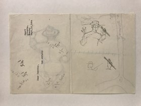
- Left: blue ink map drawing “300 yds” Right: in pencil person sitting on stool wearing hate holding paintbrush facing away from viewer.Verso: drawings of person holding paintbrush facing away from viewer. Math equations. Type written: “Banff Alberta. Sunday Sept. 19, 1954 Dear Dorothy, How awfully”
1 image
- Title
- Untitled
- Date
- 1954
- Medium
- graphite; ink on paper
- Dimensions
- 16.5 x 25.0 cm
- Description
- Left: blue ink map drawing “300 yds” Right: in pencil person sitting on stool wearing hate holding paintbrush facing away from viewer.Verso: drawings of person holding paintbrush facing away from viewer. Math equations. Type written: “Banff Alberta. Sunday Sept. 19, 1954 Dear Dorothy, How awfully”
- Credit
- Gift of Catharine Robb Whyte, O. C., Banff, 1975
- Catalogue Number
- WyP.03.952 p
Images
This material is presented as originally created; it may contain outdated cultural descriptions and
potentially offensive content.
Read more.
Map of Banff, Yoho and Kootenay Parks especially designed for the Trail Riders and the Skyline Hikers
https://archives.whyte.org/en/permalink/catalogue21346
- Medium
- Library - Maps and blueprints (unannotated; published)
- Map
- Published Date
- 1938 (approx.)
- Publisher
- Rand McNally & Co.
- Call Number
- C6-4.1(b)
- Publisher
- Rand McNally & Co.
- Published Date
- 1938 (approx.)
- Subjects
- Trail Riders Map
- Accession Number
- 540
- 5390
- Call Number
- C6-4.1(b)
- Collection
- Archives Library
This material is presented as originally created; it may contain outdated cultural descriptions and
potentially offensive content.
Read more.
Map of Banff, Yoho and Kootenay Parks especially designed for the Trail Riders and the Skyline Hikers
https://archives.whyte.org/en/permalink/catalogue21376
- Medium
- Library - Maps and blueprints (unannotated; published)
- Map
- Published Date
- 1938 (approx.)
- Publisher
- Rand McNally & Co.
- Call Number
- C6-4.1(b)
- Publisher
- Rand McNally & Co.
- Published Date
- 1938 (approx.)
- Subjects
- Trail Riders Map
- Accession Number
- 540
- 5390
- Call Number
- C6-4.1(b)
- Collection
- Archives Library
This material is presented as originally created; it may contain outdated cultural descriptions and
potentially offensive content.
Read more.


