Narrow Results By
- Peter and Catharine Whyte fonds 76
- Alpine Club of Canada fonds 10
- Bruno Engler fonds 8
- Luxton family fonds 6
- George Paris fonds 4
- Trail Riders of the Canadian Rockies fonds 4
- Archives General File Collection 3
- Underwood and Underwood Publishers fonds 3
- Dorothy Wardle fonds 2
- Elliott Barnes fonds 2
- Ron Duke fonds 2
- Whyte Museum Oral History Programme collection 2
- Ernest C. W Lamarque (1879 – 1970, Canadian) 27
- George Weber (1907 – 2002, Canadian) 25
- Peter Whyte (1905 – 1966, Canadian) 23
- Sanson, Norman 12
- Alpine Club of Canada 11
- Les Graff (1936 – , Canadian) 8
- Unknown 8
- Edward Burtynsky (1955 – , Canadian) 7
- John Hartman (1950 – , Canadian) 6
- Mather, Allan 5
- Paris, Cyril 5
- Walter Joseph Phillips, R. C. A. (1884 – 1963, Canadian) 5
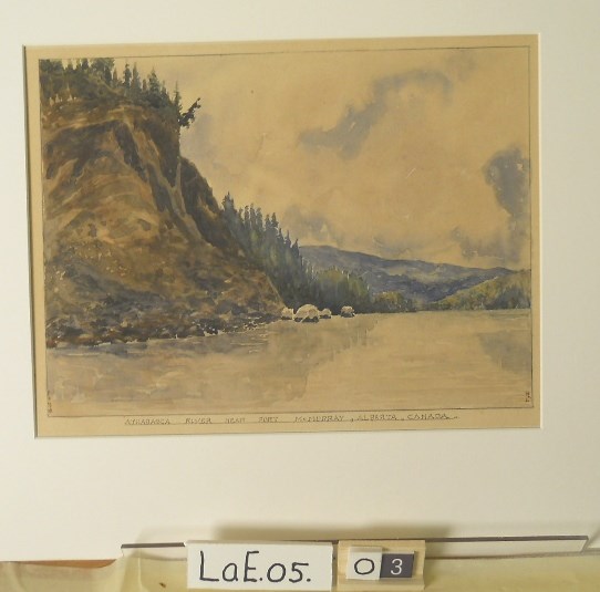
Athabasca River near Fort McMurray
https://archives.whyte.org/en/permalink/artifactlae.05.03
- Date
- 1930
- Medium
- watercolour on paper
- Catalogue Number
- LaE.05.03
- Description
- General colour: dark grey with blue and green on white. The river takes up lower third. A steep cliff rises up on the left side; there are trees on top. Blue hills can be seen in the distance on the right; trees diminish on both sides of the river. Cloudy sky above.
1 image
- Title
- Athabasca River near Fort McMurray
- Date
- 1930
- Medium
- watercolour on paper
- Dimensions
- 21.2 x 29.0 cm
- Description
- General colour: dark grey with blue and green on white. The river takes up lower third. A steep cliff rises up on the left side; there are trees on top. Blue hills can be seen in the distance on the right; trees diminish on both sides of the river. Cloudy sky above.
- Subject
- landscape
- river, Athabasca
- Ernest Lamarque
- Credit
- Gift of Ernest Lamarque (Estate), 1971
- Catalogue Number
- LaE.05.03
Images
This material is presented as originally created; it may contain outdated cultural descriptions and
potentially offensive content.
Read more.
Athabasca Valley and River, B.C.
https://archives.whyte.org/en/permalink/artifacthuw.02.03
- Date
- 1914
- Medium
- oil on paperboard
- Catalogue Number
- HuW.02.03
- Description
- Mountain range dominates top half of the picture, small glacier on one mountain. Foreground is a dark blue river with white currents. Forest at centre right and centre left. Yellow tinged river valley.
- Title
- Athabasca Valley and River, B.C.
- Date
- 1914
- Medium
- oil on paperboard
- Dimensions
- 90.6 x 103.5 cm
- Description
- Mountain range dominates top half of the picture, small glacier on one mountain. Foreground is a dark blue river with white currents. Forest at centre right and centre left. Yellow tinged river valley.
- Subject
- landscape
- Canadian Rockies
- river
- valley
- Athabasca
- Credit
- Gift of Dorothy Hutchinson, Winnipeg, 1994
- Catalogue Number
- HuW.02.03
This material is presented as originally created; it may contain outdated cultural descriptions and
potentially offensive content.
Read more.
[Athabaska River]
https://archives.whyte.org/en/permalink/catalogue24216
- Medium
- Library - Maps and blueprints (unannotated; published)
- Map
- Published Date
- 1964
- Publisher
- Department of Mines & Technical Surveys
- Call Number
- NTS
- 83
- Publisher
- Department of Mines & Technical Surveys
- Published Date
- 1964
- Physical Description
- 1 map : col
- Scale
- Scale: 1:1,000,000
- Relief: Altitude tints
- Subjects
- Athabaska River
- Accession Number
- 3000
- Call Number
- NTS
- 83
- Collection
- Archives Library
This material is presented as originally created; it may contain outdated cultural descriptions and
potentially offensive content.
Read more.
[Azure River 83D/12 B.C.]
https://archives.whyte.org/en/permalink/catalogue23458
- Medium
- Library - Maps and blueprints (unannotated; published)
- Map
- Published Date
- 1972
- Publisher
- Department of Energy, Mines and Resources
- Call Number
- NTS
- 83D/12
- Publisher
- Department of Energy, Mines and Resources
- Published Date
- 1972
- Physical Description
- 1 map : col
- Scale
- Scale: 1:50,000
- Relief: Contour interval 100 ft.
- Subjects
- Azure River
- British Columbia
- Notes
- National Topographic System
- Accession Number
- 7000
- 7030
- Call Number
- NTS
- 83D/12
- Collection
- Archives Library
This material is presented as originally created; it may contain outdated cultural descriptions and
potentially offensive content.
Read more.
Azure River 83D/12 B.C.
https://archives.whyte.org/en/permalink/catalogue23459
- Medium
- Library - Maps and blueprints (unannotated; published)
- Map
- Published Date
- 1986
- Publisher
- Surveys and Mapping Branch, Dept. of Energy, Mines and Resources
- Edition
- 3rd ed.
- Call Number
- NTS
- 83D/12
- Edition
- 3rd ed.
- Publisher
- Surveys and Mapping Branch, Dept. of Energy, Mines and Resources
- Published Date
- 1986
- Physical Description
- 1 map : col
- Scale
- Scale: 1:50,000
- Relief: Contour interval 100 feet.
- Subjects
- Azure River
- British Columbia
- Notes
- National Topographic System
- Accession Number
- 19,000
- Call Number
- NTS
- 83D/12
- Collection
- Archives Library
This material is presented as originally created; it may contain outdated cultural descriptions and
potentially offensive content.
Read more.
Banff and area businesses, townsite, scenic views
https://archives.whyte.org/en/permalink/descriptions55024
- Part Of
- Luxton family fonds
- Scope & Content
- File consists of photographs pertaining to businesses, tourist attractions and natural views in and around Banff. Includes images of backcountry camps in Banff National Park; the Bow River Boat House; Beaver Lodge and Bampton Cottage [both located on Beaver Street in Banff]; fires at Breton Hall Ho…
- Date Range
- [ca.1890-1900]
- [1896-1898]
- 1904-1905
- [ca.1910-1920]
- 1912
- 1914
- [ca.1930-1935]
- 1933
- 1941
- [ca.1950-1960]
- Reference Code
- LUX / I / D6c / PA - 133 to 182
- Description Level
- 5 / File
- GMD
- Photograph
- Photograph print
1 image
- Part Of
- Luxton family fonds
- Description Level
- 5 / File
- Fonds Number
- LUX
- Series
- LUX / I / D : Professional and Personal
- Sous-Fonds
- LUX / I : Norman Luxton sous-fonds
- Sub-Series
- LUX / I / D6 : Other activities and interests
- Accession Number
- LUX
- Reference Code
- LUX / I / D6c / PA - 133 to 182
- Responsibility
- PA-182 produced by Canadian Pacific
- Date Range
- [ca.1890-1900]
- [1896-1898]
- 1904-1905
- [ca.1910-1920]
- 1912
- 1914
- [ca.1930-1935]
- 1933
- 1941
- [ca.1950-1960]
- Physical Description
- 50 photographs ; b&w prints ; 25 x 20.5 cm or smaller
- Scope & Content
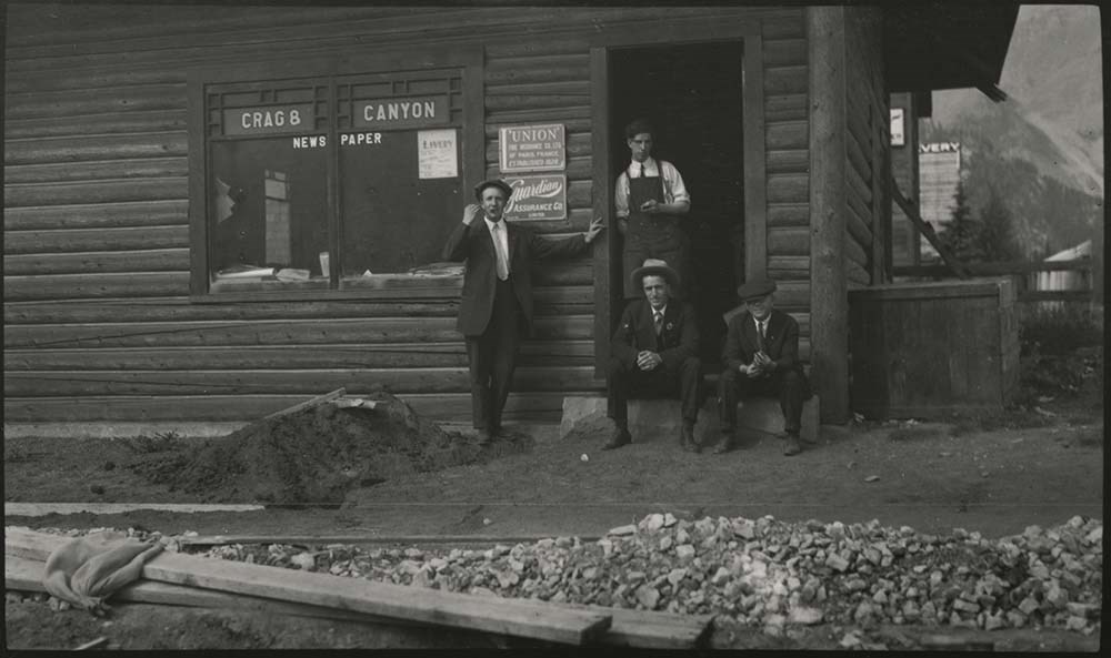
- File consists of photographs pertaining to businesses, tourist attractions and natural views in and around Banff. Includes images of backcountry camps in Banff National Park; the Bow River Boat House; Beaver Lodge and Bampton Cottage [both located on Beaver Street in Banff]; fires at Breton Hall Hotel and Banff Springs Hotel; the Park Museum and Information Bureau; early views of Banff Springs Hotel [1904]; Vermillion River Bungalow Camp and the Lake Louise Chalet; Paddy J. Nolan’s home [built by Norman Luxton]; a postcard print titled “Starved Bachelors Retreat Banff Alberta"; swimming at the Cave and Basin[?] and Banff Upper Hot Springs; the Crag and Canyon office [ca.1905]; Skoki Lodge; and the office of photographers Wilson and Fear [1896-1898].
- Notes
- Photographs LUX/I/D6c/PA-181 and 182 [depicting Wilson and Fear storefront] are copies of the same image but annotated with different dates [ca.1896 and ca.1898]. Based on context and dating of related images in Whyte Museum archives, actual image date may be closer to [ca.1894].
- Material Details
- LUX/I/D6c/PA-173 has three red sun-shaped stickers attached to back left corner, red ribbon attached to back right corner
- Name Access
- Wilson, John
- Fear, George
- Fear, William (Bill)
- Nolan, Paddy J.
- Luxton, Norman
- Smyth, S. A.
- Subject Access
- Bow River Boat House
- Pack trips
- Horses
- Teepees
- Boats
- Property
- Land use
- Hotels
- Fire
- Banff Springs Hotel
- Photography
- Businesses
- Tourism
- Hot Springs
- Leisure
- Mountain
- Newspaper
- Organizations
- Travel
- Geographic Access
- Canada
- Alberta
- Banff
- Banff National Park
- Vermilion Lakes
- Lake Louise
- Bow River
- Sulphur Mountain
- Cave and Basin
- Language
- English
- Related Material
- Items LUX/I/D6c/PA-163 to 168 have duplicate negative copies processed as LUX/I/D6c/NA-41 to 46
- Title Source
- Title based on contents of file
- Processing Status
- Processed
Images
This material is presented as originally created; it may contain outdated cultural descriptions and
potentially offensive content.
Read more.
Banff and Canmore Miscellaneous
https://archives.whyte.org/en/permalink/descriptions54667
- Part Of
- Dorothy Wardle fonds
- Scope & Content
- File consists of 90 colour photographs, 15 x 10 cm and 12.5 x 9 cm. File pertains to photographs taken by Dorothy Wardle of places, events, and scenery around Banff and Canmore. For Banff, file documents winter and fall scenery (mountains like Rundle and Cascade, the Bow River, Banff Avenue), wildl…
- Date Range
- 1993-1999
- 1993
- 1994
- 1995
- 1996
- 1999
- Reference Code
- V75 / II / PA - 138 to 228
- Description Level
- 5 / File
- GMD
- Photograph print
- Private record
- Part Of
- Dorothy Wardle fonds
- Description Level
- 5 / File
- Fonds Number
- M521 / V75
- Series
- V75 / II : Dorothy Wardle, 1972-2001
- Sous-Fonds
- V75
- Accession Number
- 7504
- Reference Code
- V75 / II / PA - 138 to 228
- Date Range
- 1993-1999
- 1993
- 1994
- 1995
- 1996
- 1999
- Physical Description
- 90 photographs : col. ; 15 x 10 cm and 12.5 x 9 cm
- Scope & Content
- File consists of 90 colour photographs, 15 x 10 cm and 12.5 x 9 cm. File pertains to photographs taken by Dorothy Wardle of places, events, and scenery around Banff and Canmore. For Banff, file documents winter and fall scenery (mountains like Rundle and Cascade, the Bow River, Banff Avenue), wildlife (elk and a bear), war memorial, Warren house, Baine house, Louis Trono concert in the park in 1995, and the Old Banff Cemetery. For Canmore, file documents the Highland Games in 1994, winter activities (ice sculptures, dog sled races at the Nordic Centre), St. Michael's Place, and a photograph of the valley. File also documents the Whyte Museum of the Canadian Rockies and the cabins (Bill Peyto, Jack Sinclair, and Mather Family) located on the museum's property.
- Notes
- Old Banff Cemetery photographs include the headstones of: Wardle family, Stephen family, Mary Schaffer Warren, J. Murray Gibbon, and Peter Whyte and Catharine Robb Whyte.
- Name Access
- Wardle, Dorothy
- Wardle, James M.
- Whyte, Peter
- Whyte, Catharine
- Schaffer, Mary
- Gibbon, John Murray
- Subject Access
- Mountain
- Scenery
- Wildlife
- War Memorial
- Highland Games
- Whyte Museum of the Canadian Rockies
- Cabins
- Bow River Bridge
- Old Banff Cemetery
- Geographic Access
- Banff
- Banff National Park
- Canmore
- Alberta
- Canada
- Canadian Rocky Mountains
- Language
- English
- Creator
- Wardle, Dorothy
- Title Source
- Title based on contents of file
- Processing Status
- Processed
This material is presented as originally created; it may contain outdated cultural descriptions and
potentially offensive content.
Read more.
Banff Area Views
https://archives.whyte.org/en/permalink/descriptions15018
- Part Of
- Elliott Barnes fonds
- Scope & Content
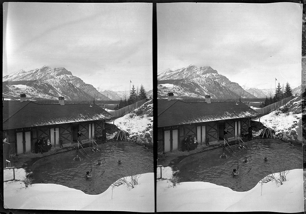
- File consists mainly of winter views of the downtown Banff area, the Hot Springs, and other scenic views around the town of Banff.
- Date Range
- [ca. 1906]
- Reference Code
- V48 / I / A / NA - 135 to 159
- Description Level
- 5 / File
- GMD
- Film
- Negative
- Transparency
25 images
- Part Of
- Elliott Barnes fonds
- Description Level
- 5 / File
- Fonds Number
- V48
- Series
- I.A. Negatives : Film
- Sous-Fonds
- V48
- Accession Number
- .
- Reference Code
- V48 / I / A / NA - 135 to 159
- GMD
- Film
- Negative
- Transparency
- Date Range
- [ca. 1906]
- Physical Description
- 25 photographs : negatives, film
- History / Biographical
- See fonds level description
- Scope & Content
- File consists mainly of winter views of the downtown Banff area, the Hot Springs, and other scenic views around the town of Banff.
- Notes
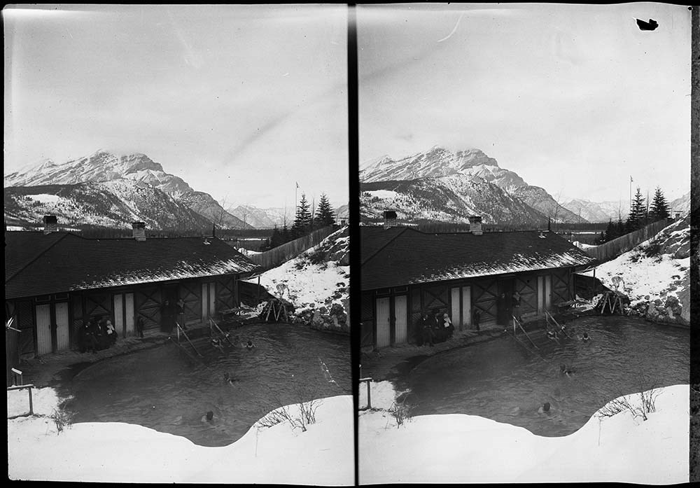
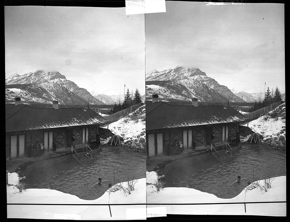
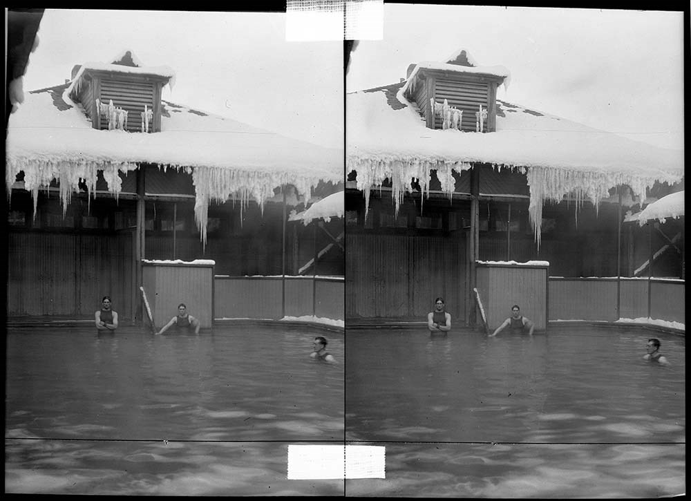
- Identifications provided by Archives LIST OF NEGATIVES :
- 135 Cave and Basin bathhouse
- 136 to 139 Cave and Basin pool and bathhouse
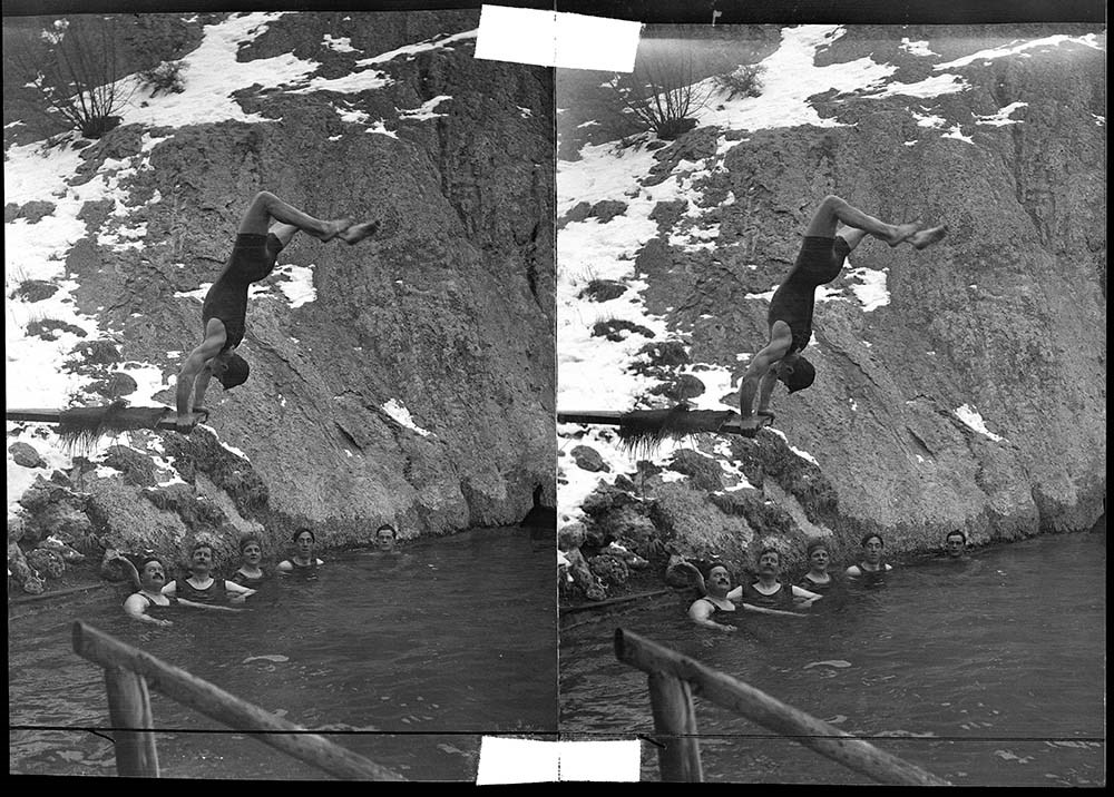
- 140 Man doing handstand on diving board at Cave and Basin pool
- 141, 142 Upper Hot Springs pool and bathhouse
- 143 The Sanitarium from across the Bow River
- 144 Government Museum
- 145 Sleigh on bridge over Bow River
- 146 Bow River Bridge and Government Museum
- 147 Mount Rundle and Bow River Bridge
- 148 Bow River and Banff Springs Hotel
- 149 Banff Springs Hotel
- 150 View from Banff Springs Hotel down the Bow Valley
- 151 Banff townsite from Sulphur Mountain
- 152 Banff from Tunnel Mountain
- 153 Banff from Mount Norquay
- 154 Mount Rundle from [Upper Hot Springs?]
- 155 Mount Rundle from the Bow River
- 156 Mount Rundle from Upper Hot Springs Road
- 157 Banff Indian Days parade on Banff Avenue
- 158 Mount Rundle from First Vermilion Lake
- 159 Cascade and Stoney Mountains
- Name Access
- Barnes, Elliott
- Subject Access
- Activities
- Cave and Basin
- Bridges
- Banff Springs Hotel
- Scenery
- Mountains
- Cascade Mountain
- Rundle Mountain
- Bow River
- Winter
- Geographic Access
- Banff
- Banff National Park
- Alberta
- Canada
- Access Restrictions
- Access by appointment only
- Language
- NA
- Title Source
- Title based on contents of file
- Processing Status
- Processed
Images


This material is presented as originally created; it may contain outdated cultural descriptions and
potentially offensive content.
Read more.
Banff flood hazard study : bow river and forty mile and echo creeks
https://archives.whyte.org/en/permalink/catalogue14692
- Medium
- Library - Book (including soft-cover and pamphlets)
- Published Date
- 25 March 2013
- Author
- North Hydraulic Consultants Ltd
- Publisher
- Edmonton, Alberta : Northwest Hydraulic Consultants Ltd
- Call Number
- 03.5 N82b Pam
- Responsibility
- prepared for Albert Environment and Sustainable Resource Development ; prepared by Northwest Hydraulic Consultants Ltd
- Publisher
- Edmonton, Alberta : Northwest Hydraulic Consultants Ltd
- Published Date
- 25 March 2013
- Physical Description
- 6 pages
- Series
- NHC project No. 100047
- Notes
- Photocopy of the original report
- Report written three months before the major flood in Southern Alberta on June 20, 2013
- Call Number
- 03.5 N82b Pam
- Collection
- Archives Library
This material is presented as originally created; it may contain outdated cultural descriptions and
potentially offensive content.
Read more.
Banff floodplain study
https://archives.whyte.org/en/permalink/catalogue5606
- Medium
- Library - Book (including soft-cover and pamphlets)
- Published Date
- 1980
- Author
- Beckstead, G.R.E.
- Publisher
- Edmonton : Alberta Environment
- Call Number
- 03.5 B38
- Author
- Beckstead, G.R.E.
- Responsibility
- prepared by G.R.E. Beckstead
- submitted by M.E. Quazi
- Publisher
- Edmonton : Alberta Environment
- Published Date
- 1980
- Physical Description
- iv, 19p. : ill., maps
- Subjects
- Bow River
- Notes
- Bibliography
- Accession Number
- 3304
- Call Number
- 03.5 B38
- Collection
- Archives Library
This material is presented as originally created; it may contain outdated cultural descriptions and
potentially offensive content.
Read more.