Narrow Results By
- Chromogenic Colour Print Photograph 49
- Oil Painting 27
- Library - Periodical 23
- Painting 19
- Library - Book (including soft-cover and pamphlets) 13
- Library - Maps and blueprints (unannotated; published)
- Map 13
- Watercolour Painting 11
- Photograph 7
- Graphite Drawing
- Lithograph Print 4
- Chromogenic Colour Print Photograph 3
- Crowsnest Forest 3
- forest 2
- landscape 2
- Rocky Mountains Forest Reserve 2
- Alberta-Forest Protection Areas 1
- Animals 1
- Bow River Forest Reserve 1
- Clearwater Forest, Rocky Mountains Forest Reserve 1
- Crowsnest Forest and Waterton Lakes Park 1
- Crowsnest Forest Reserve 1
- Cypress Hills Forest Reserve 1
- farm 1
[Alberta-Forest Protection Areas]
https://archives.whyte.org/en/permalink/catalogue23246
- Medium
- Library - Maps and blueprints (unannotated; published)
- Map
- Published Date
- April 1st, 1974
- Publisher
- Surveys Branch, Department of Highways and Transport
- Call Number
- C2-11.6
- Publisher
- Surveys Branch, Department of Highways and Transport
- Published Date
- April 1st, 1974
- Scale
- Scale: 1":50 miles
- Subjects
- Alberta-Forest Protection Areas
- Notes
- Legend in Green
- Accession Number
- SG7500
- Call Number
- C2-11.6
- Collection
- Archives Library
This material is presented as originally created; it may contain outdated cultural descriptions and
potentially offensive content.
Read more.
Athabaska Forest
https://archives.whyte.org/en/permalink/catalogue23248
- Medium
- Library - Maps and blueprints (unannotated; published)
- Map
- Published Date
- 1920 (signed Dec. 1919. Calgary/R.D.M)
- Publisher
- 1920 Forestry Branch
- Call Number
- C2-11.8
- Responsibility
- R.H. Campbell
- Publisher
- 1920 Forestry Branch
- Published Date
- 1920 (signed Dec. 1919. Calgary/R.D.M)
- Scale
- Scale: 3 miles to an inch
- Subjects
- Rocky Mountains Forest Reserve
- Notes
- Prepared under direction of R.H. Campbell Director of Forestry
- Call Number
- C2-11.8
- Collection
- Archives Library
This material is presented as originally created; it may contain outdated cultural descriptions and
potentially offensive content.
Read more.
[Bow River Forest Reserve]
https://archives.whyte.org/en/permalink/catalogue23240
- Medium
- Library - Maps and blueprints (unannotated; published)
- Map
- Published Date
- 1965
- Publisher
- Dept. of Lands, Forests
- Call Number
- C2-11.2a
- Publisher
- Dept. of Lands, Forests
- Published Date
- 1965
- Physical Description
- 1 map : col
- Scale
- Scale: 1 inch : 3 miles
- Altitude tints
- Subjects
- Bow River Forest Reserve
- Notes
- C2-11.2b - 1970 reprint - Accn. 3000
- Accession Number
- 718
- Call Number
- C2-11.2a
- Collection
- Archives Library
This material is presented as originally created; it may contain outdated cultural descriptions and
potentially offensive content.
Read more.
[Clearwater Forest, Rocky Mountains Forest Reserve]
https://archives.whyte.org/en/permalink/catalogue23243
- Medium
- Library - Maps and blueprints (unannotated; published)
- Map
- Published Date
- 1971
- Publisher
- Dept. of Lands and Forests
- Call Number
- C2-11.4
- Publisher
- Dept. of Lands and Forests
- Published Date
- 1971
- Physical Description
- 1 map : col
- Scale
- Scale: 1" : 3 miles
- Altitude tints
- Accession Number
- 3000
- Call Number
- C2-11.4
- Collection
- Archives Library
This material is presented as originally created; it may contain outdated cultural descriptions and
potentially offensive content.
Read more.
[Crowsnest Forest Reserve]
https://archives.whyte.org/en/permalink/catalogue23241
- Medium
- Library - Maps and blueprints (unannotated; published)
- Map
- Published Date
- 1962 (Revised 1968)
- Publisher
- Dept. of Lands and Forests
- Call Number
- C2-11.3
- Publisher
- Dept. of Lands and Forests
- Published Date
- 1962 (Revised 1968)
- Physical Description
- 1 map : col
- Scale
- Scale: 1 inch : 3 miles
- Altitude tints
- Subjects
- Crowsnest Forest Reserve
- Accession Number
- 3000
- Call Number
- C2-11.3
- Collection
- Archives Library
This material is presented as originally created; it may contain outdated cultural descriptions and
potentially offensive content.
Read more.
[Cypress Hills Forest Reserve]
https://archives.whyte.org/en/permalink/catalogue23238
- Medium
- Library - Maps and blueprints (unannotated; published)
- Map
- Published Date
- 1927
- Publisher
- Dept. of The Interior
- Call Number
- C2-11.1
- Publisher
- Dept. of The Interior
- Published Date
- 1927
- Physical Description
- 1 map : col
- Scale
- Scale: 1 inch : 1 mile
- Contour Interval 20 feet
- Subjects
- Cypress Hills Forest Reserve
- Accession Number
- 718
- Call Number
- C2-11.1
- Collection
- Archives Library
This material is presented as originally created; it may contain outdated cultural descriptions and
potentially offensive content.
Read more.
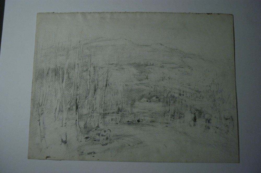
Farm in the Forest
https://archives.whyte.org/en/permalink/artifactcoj.03.198
- Date
- n.d.
- Medium
- graphite on paper
- Catalogue Number
- CoJ.03.198
- Description
- Group of ten trees blc and along left side, under trees there is a cart, in mid-distance there is a house, behing the house hills slope up to the bottom of a mountainous range.“This sketch belongs to a small group of ambiguous pencil drawings ranging in date from early English works to late Canadia…
1 image
- Title
- Farm in the Forest
- Date
- n.d.
- Medium
- graphite on paper
- Dimensions
- 28.5 x 38.7 cm
- Description
- Group of ten trees blc and along left side, under trees there is a cart, in mid-distance there is a house, behing the house hills slope up to the bottom of a mountainous range.“This sketch belongs to a small group of ambiguous pencil drawings ranging in date from early English works to late Canadian examples. The atmosphere is invariably one o mystery, misty (as in this), or foggy, or shadowy, and the subjects lend themselves to several interpretations.” -- “Charles John Collings, 1848-1931” Catalogue Raisonne by Linda Heath
- Credit
- Gift of John Rivette, Seymour Arm, 1986
- Catalogue Number
- CoJ.03.198
Images
This material is presented as originally created; it may contain outdated cultural descriptions and
potentially offensive content.
Read more.
Forest Oliver (Pat) Brewster
https://archives.whyte.org/en/permalink/artifactcrj.03.01
- Artist
- Josephine Crumrine
- Date
- n.d.
- Medium
- graphite on paper
- Catalogue Number
- CrJ.03.01
- Description
- Placed in the center of the drawing paper is the portrait of a man. The man is wearing a suit and a tie. The portrait is from the chest area up. This subject has a pleasant face and is looking slightly to the left side of the image, with his head turned a bit to the right. His tie and suit jacke…
1 image
- Artist
- Josephine Crumrine
- Title
- Forest Oliver (Pat) Brewster
- Date
- n.d.
- Medium
- graphite on paper
- Description
- Placed in the center of the drawing paper is the portrait of a man. The man is wearing a suit and a tie. The portrait is from the chest area up. This subject has a pleasant face and is looking slightly to the left side of the image, with his head turned a bit to the right. His tie and suit jacket are shaded with diagonal lines.
- Subject
- Portrait
- Male
- Forest Oliver (Pat) Brewster
- Credit
- Gift of Pearl Evelyn Moore, Banff, 1979
- Catalogue Number
- CrJ.03.01
Images

This material is presented as originally created; it may contain outdated cultural descriptions and
potentially offensive content.
Read more.
Plan of Control Survey
https://archives.whyte.org/en/permalink/catalogue23244
- Medium
- Library - Maps and blueprints (unannotated; published)
- Map
- Published Date
- May 31, 1961
- Publisher
- Dept. of Highways
- Call Number
- C2-11.5(a)
- Publisher
- Dept. of Highways
- Published Date
- May 31, 1961
- Scale
- Scale: 1:250,000
- Subjects
- Rocky Mountains Forest Reserve Area
- Notes
- Legend in Colour
- Accession Number
- SG7500
- Call Number
- C2-11.5(a)
- Collection
- Archives Library
This material is presented as originally created; it may contain outdated cultural descriptions and
potentially offensive content.
Read more.
Plan of S.W. 1/4 Township 26, Range 15, West of the Fifth Meridian showing Yoho Forest Reserve
https://archives.whyte.org/en/permalink/catalogue23247
- Medium
- Library - Maps and blueprints (unannotated; published)
- Map
- Publisher
- Dept. of the Interior
- Call Number
- C2-11.7
- Publisher
- Dept. of the Interior
- Scale
- Scale: 20 chains to the inch
- Series
- Mar. 12, 1917
- Subjects
- Yoho Forest Reserve
- Accession Number
- SG7500
- Call Number
- C2-11.7
- Collection
- Archives Library
This material is presented as originally created; it may contain outdated cultural descriptions and
potentially offensive content.
Read more.