Narrow Results By
- George Weber (1907 – 2002, Canadian) 2
- Sitting Wind (1925 – 2002, Canadian) 2
- Alpine Club of Canada 1
- Baird, David M. 1
- Campbell, P. I 1
- Engler, Bruno 1
- Golden and District Historical Society 1
- Janet Holly Middleton (1922 – 2018, Canadian) 1
- Murray, George 1
- Murray, Gertrude 1
- Nelson, James Gordon 1
- Nicholas Morant 1
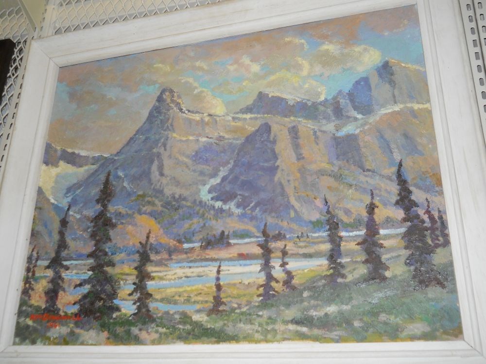
Pilot Mountain
https://archives.whyte.org/en/permalink/artifactdnr.02.01
- Artist
- Robert M. Dingwall
- Date
- 1961
- Medium
- oil on canvas
- Catalogue Number
- DnR.02.01
- Description
- In the bottom third of painting is thirteen single trees and a river with islands in it. The purple shadowed mountain rises up from there. A glacier on the left, the main peak left of center and two distant peaks to the right. Skin tone and yellow tinted clouds fill the top third. The signature in …
1 image
- Artist
- Robert M. Dingwall
- Title
- Pilot Mountain
- Date
- 1961
- Medium
- oil on canvas
- Dimensions
- 54.9 x 70.3 cm
- Description
- In the bottom third of painting is thirteen single trees and a river with islands in it. The purple shadowed mountain rises up from there. A glacier on the left, the main peak left of center and two distant peaks to the right. Skin tone and yellow tinted clouds fill the top third. The signature in the lower left is signed in orange red.
- Credit
- Gift of eisler, Edmonton, 1972
- Catalogue Number
- DnR.02.01
Images
This material is presented as originally created; it may contain outdated cultural descriptions and
potentially offensive content.
Read more.
[Glacier 82 N/5 East - B.C.]
https://archives.whyte.org/en/permalink/catalogue23628
- Medium
- Library - Maps and blueprints (unannotated; published)
- Map
- Published Date
- 1963
- Publisher
- Dept. of Mines and Technical Surveys
- Call Number
- NTS
- 82N/5E
- Publisher
- Dept. of Mines and Technical Surveys
- Published Date
- 1963
- Physical Description
- Colour
- Scale
- Scale: 1:50,000
- Relief: Contour interval 100'
- Subjects
- Glacier 82 N/5 East - B.C.
- Notes
- National Topographic System
- Call Number
- NTS
- 82N/5E
- Collection
- Archives Library
This material is presented as originally created; it may contain outdated cultural descriptions and
potentially offensive content.
Read more.
[Glacier 82 N/5 West B.C.]
https://archives.whyte.org/en/permalink/catalogue23629
- Medium
- Library - Maps and blueprints (unannotated; published)
- Map
- Published Date
- 1963
- Publisher
- Dept. of Mines and Technical Surveys
- Call Number
- NTS
- 82N/5W
- Publisher
- Dept. of Mines and Technical Surveys
- Published Date
- 1963
- Physical Description
- Colour
- Scale
- Scale: 1:50,000
- Relief: Contour interval 100'
- Subjects
- Glacier 82 N/5 West B.C.
- Notes
- National Topographic System
- Call Number
- NTS
- 82N/5W
- Collection
- Archives Library
This material is presented as originally created; it may contain outdated cultural descriptions and
potentially offensive content.
Read more.
Athabasca Glacier, Columbia Icefield
https://archives.whyte.org/en/permalink/artifactwbg.04.087
- Date
- 1963
- Medium
- ink on paper
- Catalogue Number
- WbG.04.087
- Description
- Wildflowers and black trees in foreground, Athabasca Glacier in distance.
- Title
- Athabasca Glacier, Columbia Icefield
- Date
- 1963
- Medium
- ink on paper
- Dimensions
- 21.7 x 29.4 cm
- Description
- Wildflowers and black trees in foreground, Athabasca Glacier in distance.
- Credit
- Gift of Donna Tingley, Edmonton, 2004
- Catalogue Number
- WbG.04.087
This material is presented as originally created; it may contain outdated cultural descriptions and
potentially offensive content.
Read more.
Kenai Mts., Alaska
https://archives.whyte.org/en/permalink/catalogue23311
- Medium
- Library - Maps and blueprints (unannotated; published)
- Map
- Published Date
- 1964
- Call Number
- C5-3.4
- Published Date
- 1964
- Physical Description
- Black & white
- Scale
- 1 mile: 1 5/8 inches
- Subjects
- Terminus of Portage Glacier
- Accession Number
- 916
- Call Number
- C5-3.4
- Collection
- Archives Library
This material is presented as originally created; it may contain outdated cultural descriptions and
potentially offensive content.
Read more.
[Baffin Island, Lewis Glacier, Barnes Ice Cap 37E/6E] District of Franklin, Northwest Territories
https://archives.whyte.org/en/permalink/catalogue23467
- Medium
- Library - Maps and blueprints (unannotated; published)
- Map
- Published Date
- 1964
- Publisher
- Department of Mines and Technical Surveys
- Call Number
- NTS
- 37E/6E
- Publisher
- Department of Mines and Technical Surveys
- Published Date
- 1964
- Physical Description
- 1 map : black and white
- Scale
- Scale: 1:50,000
- Relief: Contour intervals
- Notes
- National Topographic System
- Arctic provisional map
- Accession Number
- 7000
- Call Number
- NTS
- 37E/6E
- Collection
- Archives Library
This material is presented as originally created; it may contain outdated cultural descriptions and
potentially offensive content.
Read more.
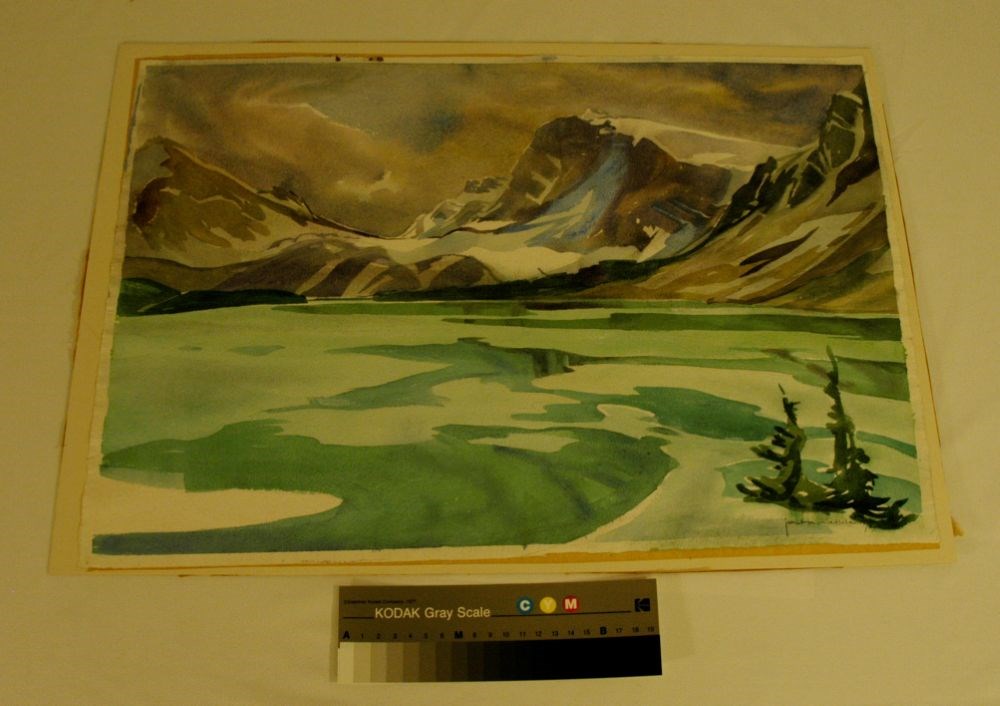
Bow Lake and Crowfoot Glacier
https://archives.whyte.org/en/permalink/artifactmij.05.06
- Date
- 1964
- Medium
- watercolour on paper
- Catalogue Number
- MiJ.05.06
- Description
- The general colours are green, blue, grey, brown, mauve, purple and white. The painting is divided in half for dominance. The bottom-half is the icy blue/green and white of the frozen lake; on the viewer’s far right there are two small evergreens in the snow. The top-half comprises the mountains an…
1 image
- Title
- Bow Lake and Crowfoot Glacier
- Date
- 1964
- Medium
- watercolour on paper
- Dimensions
- 37.2 x 56.0 cm
- Description
- The general colours are green, blue, grey, brown, mauve, purple and white. The painting is divided in half for dominance. The bottom-half is the icy blue/green and white of the frozen lake; on the viewer’s far right there are two small evergreens in the snow. The top-half comprises the mountains and glacier; viewer’s right the scree slope and upward sweep of a mountain, moving to the left is the next mountain with its white and blue glacier top and blue sweep down the middle of the mountain. Lower mid-centre is the glacier snow field and to the left is a brown and white mountain. The gloomy sky is grey and white swirling clouds with hints of yellow through the grey and blue sky beyond.
- Credit
- Gift of Mary Garnham Andrews, Banff, 2009
- Catalogue Number
- MiJ.05.06
Images
This material is presented as originally created; it may contain outdated cultural descriptions and
potentially offensive content.
Read more.
Glacier and Mount Revelstoke National parks: where rivers are born
https://archives.whyte.org/en/permalink/catalogue19860
- Medium
- Library - Book (including soft-cover and pamphlets)
- Published Date
- 1965
- Author
- Baird, David M.
- Publisher
- Ottawa, Geological survey of Canada, Dept. of mines and technical surveys
- Call Number
- 13.115 B11g Pam
- Author
- Baird, David M.
- Responsibility
- David M. Baird
- Publisher
- Ottawa, Geological survey of Canada, Dept. of mines and technical surveys
- Published Date
- 1965
- Physical Description
- v, 104 pages illustrations, maps (1 folded color). 18 cm.
- Subjects
- Geology
- Geology - British Columbia
- Mount Revelstoke National Park
- Glacier National Park
- British Columbia
- Banff National Park
- Abstract
- Pertains to the geology of Glacier and Mount Revelstoke National parks. While providing an overview of the geology, the author also provides the reader with specific details making the experience well rounded. The content pertains to the Rocky Mountains and makes specific mention to Banff and Banff National park
- Contents
- Introduction
- Divides
- Boundaries of the parks
- Origin of the mountains
- The rocks
- The sculpturing of the mountains
- Regional differences in the mountains
- Shapes of mountains
- Roadlog and points of interest along the Trans-Canada Highway
- Epilogue
- Index
- Notes
- The page numbers for the following locations listed in the abstract are as follows; Banff (37), Banff National Park (vi, 4, 19, 37 and 40)
- Accession Number
- 2017.8683
- Call Number
- 13.115 B11g Pam
- Collection
- Archives Library
This material is presented as originally created; it may contain outdated cultural descriptions and
potentially offensive content.
Read more.
Canada's mountain national parks : Banff, Jasper, Glacier, Kootenay, Mount Revelstoke, Waterton Lakes, Yoho
https://archives.whyte.org/en/permalink/catalogue19864
- Medium
- Library - Book (including soft-cover and pamphlets)
- Published Date
- 1966
- Author
- Scharff, Robert
- Publisher
- Vancouver : Evergreen Press Limited
- Toronto : Musson Book Company
- Call Number
- 13.113 Sch1c Pam
- Author
- Scharff, Robert
- Responsibility
- by Robert Scharff, in association with the Natural and Historic Resources Branch, Dept. of Northern Affairs and Natural Resources
- Publisher
- Vancouver : Evergreen Press Limited
- Toronto : Musson Book Company
- Published Date
- 1966
- Physical Description
- vii, 184 pages : illustrations (some color), maps ; 22 cm
- Subjects
- National parks
- Banff National Park
- Guide
- Jasper National Park
- Kootenay National Park
- Glacier National Park
- Mount Revelstoke National Park
- Waterton Lakes National Park
- Yoho National Park
- Abstract
- Pertains to a guide on Canada’s National Parks. This comprehensive guide offers readers a brief history of each Mountain National Park, as well as other useful information pertaining to risk reduction, camping, environmental preservation, wildlife preservation and sightseeing. Additionally, Robert Scharff includes information regarding activities that may be of interest to visitors such as cycling, canoeing, climbing, hiking, trail riding and more. Refers to Banff, Jasper, Glacier, Kootenay, Mount Revelstoke, Waterton Lakes and Yoho National Parks.
- Contents
- Chapter one - introduction to the mountain national parks (pg. 1)
- Chapter two - sightseeing in the parks (pg. 34)
- Chapter three - seeing the wilderness areas of the park (pg. 87)
- Chapter four - plant life in the parks (pg. 110)
- Chapter five - wildlife and birds in the parks (pg. 119)
- Chapter six - fishing in the parks (pg. 142)
- Chapter seven - winter in the parks (pg. 149)
- Chapter eight - accomodations and service in the parks (pg. 158)
- Accession Number
- 2017.8683
- Call Number
- 13.113 Sch1c Pam
- Collection
- Archives Library
This material is presented as originally created; it may contain outdated cultural descriptions and
potentially offensive content.
Read more.
- Medium
- Library - Maps and blueprints (unannotated; published)
- Map
- Published Date
- 1967
- Publisher
- Inland Waters Branch, Dept. of Energy, Mines and Resources
- Call Number
- C5-2.1a
- Publisher
- Inland Waters Branch, Dept. of Energy, Mines and Resources
- Published Date
- 1967
- Scale
- Scale: 1:10,000
- Contour interval: 10 metres on Woolsey Glacier, 50 metres elsewhere
- Subjects
- Woolsey Glacier, B.C.
- Notes
- Two duplicates in map room
- Accession Number
- 672
- 778
- Call Number
- C5-2.1a
- Collection
- Archives Library
This material is presented as originally created; it may contain outdated cultural descriptions and
potentially offensive content.
Read more.