Narrow Results By
[Glacier Park]
https://archives.whyte.org/en/permalink/catalogue23221
- Medium
- Library - Maps and blueprints (unannotated; published)
- Map
- Published Date
- 1911
- Publisher
- Dept. of the Interior
- Call Number
- C2-7.2
- Publisher
- Dept. of the Interior
- Published Date
- 1911
- Physical Description
- 1 map : black and white
- Scale
- Scale: 2 miles to 1 inch
- Relief: Spot heights
- Subjects
- Glacier National Park
- Accession Number
- 400
- Call Number
- C2-7.2
- Collection
- Archives Library
This material is presented as originally created; it may contain outdated cultural descriptions and
potentially offensive content.
Read more.
British Columbia Railway Belt
https://archives.whyte.org/en/permalink/catalogue24629
- Medium
- Library - Maps and blueprints (unannotated; published)
- Map
- Published Date
- 1913
- Publisher
- Dept. of the Interior
- Call Number
- C3-5.2
- Publisher
- Dept. of the Interior
- Published Date
- 1913
- Scale
- Scale: 3 miles to 1 inch
- Relief: Spot heights
- Subjects
- Parks - Glacier and Yoho
- Notes
- Donald Sheet
- Accession Number
- 400
- Call Number
- C3-5.2
- Collection
- Archives Library
This material is presented as originally created; it may contain outdated cultural descriptions and
potentially offensive content.
Read more.
[Glacier Park]
https://archives.whyte.org/en/permalink/catalogue23223
- Medium
- Library - Maps and blueprints (unannotated; published)
- Map
- Published Date
- 1923
- Publisher
- Dept. of the Interior
- Call Number
- C2-7.4
- Publisher
- Dept. of the Interior
- Published Date
- 1923
- Scale
- Scale: 1.97 miles to 1 inch
- Relief: Contour Interval 250'
- Subjects
- Glacier National Park
- Notes
- 4 duplicates in map room - 3 Accn. 400, 1 Accn. 1105
- Accession Number
- 400
- 1105
- Call Number
- C2-7.4
- Collection
- Archives Library
This material is presented as originally created; it may contain outdated cultural descriptions and
potentially offensive content.
Read more.
[Garibaldi Park - Glacier Area]
https://archives.whyte.org/en/permalink/catalogue23302
- Medium
- Library - Maps and blueprints (unannotated; published)
- Map
- Published Date
- 1926
- Author
- Carter, N.M.
- Call Number
- C5-2.3(c)
- Author
- Carter, N.M.
- Published Date
- 1926
- Scale
- Scale: 1/2 mile - 1 inch
- Subjects
- Garibaldi Park - Glacier Area
- Notes
- Hand drawn by N.M. Carter
- watercolour
- Accession Number
- 2553
- Call Number
- C5-2.3(c)
- Collection
- Archives Library
This material is presented as originally created; it may contain outdated cultural descriptions and
potentially offensive content.
Read more.
Victoria Glacier, Buttress of Mount Lefroy
https://archives.whyte.org/en/permalink/artifactwyp.01.544
- Date
- 1931
- Medium
- oil on canvas
- Catalogue Number
- WyP.01.544
1 image
- Title
- Victoria Glacier, Buttress of Mount Lefroy
- Date
- 1931
- Medium
- oil on canvas
- Dimensions
- 40.7 x 40.5 cm
- Credit
- Gift of Catharine Robb Whyte, O. C., Banff, 1979
- Catalogue Number
- WyP.01.544
Images

This material is presented as originally created; it may contain outdated cultural descriptions and
potentially offensive content.
Read more.
[Glacier Park]
https://archives.whyte.org/en/permalink/catalogue23224
- Medium
- Library - Maps and blueprints (unannotated; published)
- Map
- Published Date
- 1934
- Publisher
- Dept. of the Interior
- Call Number
- C2-7.5
- Publisher
- Dept. of the Interior
- Published Date
- 1934
- Scale
- Scale: 1" : 2 miles
- Contour Interval 200'
- Subjects
- Glacier National Park
- Accession Number
- 718
- Call Number
- C2-7.5
- Collection
- Archives Library
This material is presented as originally created; it may contain outdated cultural descriptions and
potentially offensive content.
Read more.
Glacier Park, B.C.
https://archives.whyte.org/en/permalink/catalogue23225
- Medium
- Library - Maps and blueprints (unannotated; published)
- Map
- Published Date
- 1946
- Publisher
- Ottawa, Tophographical Survey of Canada
- Call Number
- C2-7.5a
- Publisher
- Ottawa, Tophographical Survey of Canada
- Published Date
- 1946
- Physical Description
- 1 map : col
- Scale
- Scale: 1:126,720
- Subjects
- Glacier National Park
- Accession Number
- 3349
- Call Number
- C2-7.5a
- Collection
- Archives Library
This material is presented as originally created; it may contain outdated cultural descriptions and
potentially offensive content.
Read more.
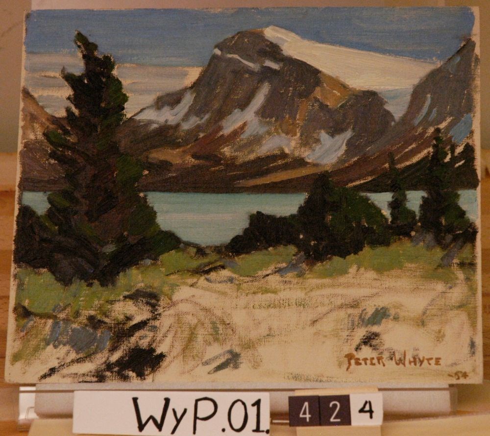
Crowfoot Glacier, Bow Lake
https://archives.whyte.org/en/permalink/artifactwyp.01.424
- Date
- 1954
- Medium
- oil on canvas
- Catalogue Number
- WyP.01.424
1 image
- Title
- Crowfoot Glacier, Bow Lake
- Date
- 1954
- Medium
- oil on canvas
- Dimensions
- 25.1 x 30.2 cm
- Subject
- landscape
- Canadian Rockies
- mountain
- lake
- glacier
- Credit
- Gift of Catharine Robb Whyte, O. C., Banff, 1979
- Catalogue Number
- WyP.01.424
Images
This material is presented as originally created; it may contain outdated cultural descriptions and
potentially offensive content.
Read more.
[Glacier Park 82N/SW, B.C.]
https://archives.whyte.org/en/permalink/catalogue23979
- Medium
- Library - Maps and blueprints (unannotated; published)
- Map
- Published Date
- 1955
- Publisher
- Dept. of Mines and Technical Surveys
- Call Number
- NTS
- 82N/SW
- Publisher
- Dept. of Mines and Technical Surveys
- Published Date
- 1955
- Physical Description
- 1 map : col
- Scale
- Scale: 1:126,720
- Relief: Contour interval 200 ft.
- Subjects
- Glacier Park
- British Columbia
- Notes
- National Topographic System
- Dup. in Research Room
- Dup. C2-7.6
- Accession Number
- 3000
- 673
- Call Number
- NTS
- 82N/SW
- Collection
- Archives Library
This material is presented as originally created; it may contain outdated cultural descriptions and
potentially offensive content.
Read more.
[Glacier Park]
https://archives.whyte.org/en/permalink/catalogue23226
- Medium
- Library - Maps and blueprints (unannotated; published)
- Map
- Published Date
- 1955
- Publisher
- Dept. of Mines and Technical Surveys
- Call Number
- C2-7.6
- Publisher
- Dept. of Mines and Technical Surveys
- Published Date
- 1955
- Physical Description
- 1 map : col
- Scale
- Scale: 2 miles to 1 inch
- Relief: Contour interval 100 ft.
- Subjects
- Glacier National Park
- Notes
- Topo 82N/SW
- 1 duplicate in 1:126,720 drawer - Accn. 3000
- Accession Number
- 673
- Call Number
- C2-7.6
- Collection
- Archives Library
This material is presented as originally created; it may contain outdated cultural descriptions and
potentially offensive content.
Read more.