Narrow Results By
[Baffin Island, Lewis Glacier, Barnes Ice Cap 37E/6E] District of Franklin, Northwest Territories
https://archives.whyte.org/en/permalink/catalogue23467
- Medium
- Library - Maps and blueprints (unannotated; published)
- Map
- Published Date
- 1964
- Publisher
- Department of Mines and Technical Surveys
- Call Number
- NTS
- 37E/6E
- Publisher
- Department of Mines and Technical Surveys
- Published Date
- 1964
- Physical Description
- 1 map : black and white
- Scale
- Scale: 1:50,000
- Relief: Contour intervals
- Notes
- National Topographic System
- Arctic provisional map
- Accession Number
- 7000
- Call Number
- NTS
- 37E/6E
- Collection
- Archives Library
This material is presented as originally created; it may contain outdated cultural descriptions and
potentially offensive content.
Read more.
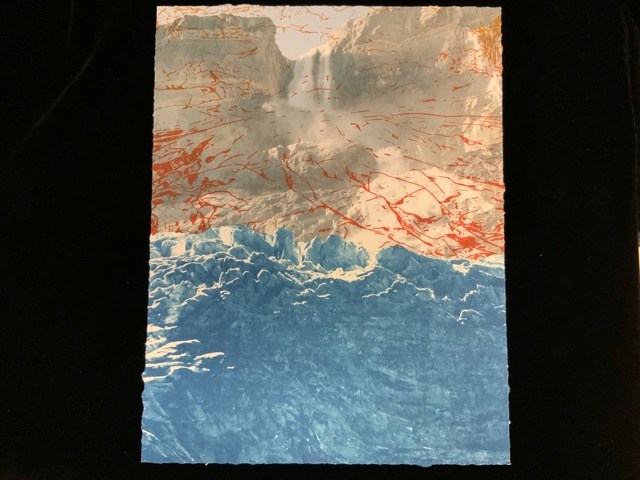
Bow Glacier Falls, 1902/2019
https://archives.whyte.org/en/permalink/artifactstk.04.05
- Artist
- Kelsey Stephenson
- Date
- 2019
- Medium
- ink on paper
- Catalogue Number
- StK.04.05
- Description
- A colour photograph of a waterfall (Bow Glacier Falls) tumbling over a rocky ridge. Overlaid is a screenprinted drawing of previous reaches of the glacier. The bottom half of the image is cyanotype detail of the glacier from archival photographs.
1 image
- Artist
- Kelsey Stephenson
- Title
- Bow Glacier Falls, 1902/2019
- Date
- 2019
- Medium
- ink on paper
- Dimensions
- 35.5 x 28.8 cm
- Description
- A colour photograph of a waterfall (Bow Glacier Falls) tumbling over a rocky ridge. Overlaid is a screenprinted drawing of previous reaches of the glacier. The bottom half of the image is cyanotype detail of the glacier from archival photographs.
- Subject
- Bow Glacier
- Bow Glacier Falls
- Bow Falls
- Credit
- Gift of Kelsey Stephenson, Edmonton, 2023
- Catalogue Number
- StK.04.05
Images
This material is presented as originally created; it may contain outdated cultural descriptions and
potentially offensive content.
Read more.
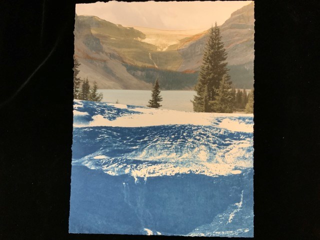
Bow Lake, 1902/2021
https://archives.whyte.org/en/permalink/artifactstk.04.03
- Artist
- Kelsey Stephenson
- Date
- 2021
- Medium
- ink on paper
- Catalogue Number
- StK.04.03
- Description
- A digital print in which the top half is a full colour image of Bow Lake with trees in front, Bow Glacier Falls, and Bow Glacier sitting atop of rocky ridge in the background. The photograph is overlaid with digital ink drawing of the glacier’s reach in 1902 from an archival photograph. The bottom …
1 image
- Artist
- Kelsey Stephenson
- Title
- Bow Lake, 1902/2021
- Date
- 2021
- Medium
- ink on paper
- Dimensions
- 35.5 x 28.0 cm
- Description
- A digital print in which the top half is a full colour image of Bow Lake with trees in front, Bow Glacier Falls, and Bow Glacier sitting atop of rocky ridge in the background. The photograph is overlaid with digital ink drawing of the glacier’s reach in 1902 from an archival photograph. The bottom half of the image is a cyanotype of the glacier in 1902.
- Subject
- Bow Lake
- Bow Glacier
- Banff National Park
- Credit
- Gift of Kelsey Stephenson, Edmonton, 2023
- Catalogue Number
- StK.04.03
Images
This material is presented as originally created; it may contain outdated cultural descriptions and
potentially offensive content.
Read more.
British Columbia Railway Belt
https://archives.whyte.org/en/permalink/catalogue24629
- Medium
- Library - Maps and blueprints (unannotated; published)
- Map
- Published Date
- 1913
- Publisher
- Dept. of the Interior
- Call Number
- C3-5.2
- Publisher
- Dept. of the Interior
- Published Date
- 1913
- Scale
- Scale: 3 miles to 1 inch
- Relief: Spot heights
- Subjects
- Parks - Glacier and Yoho
- Notes
- Donald Sheet
- Accession Number
- 400
- Call Number
- C3-5.2
- Collection
- Archives Library
This material is presented as originally created; it may contain outdated cultural descriptions and
potentially offensive content.
Read more.
[Bugaboo Glacier B.C.]
https://archives.whyte.org/en/permalink/catalogue21330
- Medium
- Library - Maps and blueprints (unannotated; published)
- Map
- Published Date
- 1973
- Publisher
- Dept. of Environment/Ottawa
- Call Number
- C5-2.6(e)
- Publisher
- Dept. of Environment/Ottawa
- Published Date
- 1973
- Series
- Sheet #5 Glacier map series #5
- Subjects
- Bugaboo Glacier
- Notes
- Sheet #5 Glacier map series #5
- Accompanies 03.4/R27 "Glacier Surveys In British Columbia 1972"
- Accession Number
- 11000
- Call Number
- C5-2.6(e)
- Collection
- Archives Library
This material is presented as originally created; it may contain outdated cultural descriptions and
potentially offensive content.
Read more.
Bugaboo Glacier, British Columbia, Canada
https://archives.whyte.org/en/permalink/catalogue23305
- Medium
- Library - Maps and blueprints (unannotated; published)
- Map
- Published Date
- 1979
- Publisher
- Ottawa : Inland Waters Directorate
- Call Number
- C5-2.6e
- Publisher
- Ottawa : Inland Waters Directorate
- Published Date
- 1979
- Physical Description
- 1 map : col
- Scale
- Scale: 1 : 2,500
- Subjects
- Bugaboo Glacier
- Notes
- To be used with publication 03.4/R27/1978
- Accession Number
- 3398
- Call Number
- C5-2.6e
- Collection
- Archives Library
This material is presented as originally created; it may contain outdated cultural descriptions and
potentially offensive content.
Read more.
Dinwoody Glacier
https://archives.whyte.org/en/permalink/catalogue21331
- Medium
- Library - Maps and blueprints (unannotated; published)
- Map
- Published Date
- 1950-1952
- Author
- Meier, Mark F.
- Publisher
- Research Committee, American Alpine Club
- Call Number
- C5-4.1
- Author
- Meier, Mark F.
- Publisher
- Research Committee, American Alpine Club
- Published Date
- 1950-1952
- Subjects
- Glacier Map
- Notes
- Wind River Mountains, Wyoming
- Geology by Mark F. Meier
- Base map compiled from air photos
- Text on back of map. Photo of glacier.
- Accession Number
- 2613
- Call Number
- C5-4.1
- Collection
- Archives Library
This material is presented as originally created; it may contain outdated cultural descriptions and
potentially offensive content.
Read more.
[Garibaldi Park - Glacier Area]
https://archives.whyte.org/en/permalink/catalogue23302
- Medium
- Library - Maps and blueprints (unannotated; published)
- Map
- Published Date
- 1926
- Author
- Carter, N.M.
- Call Number
- C5-2.3(c)
- Author
- Carter, N.M.
- Published Date
- 1926
- Scale
- Scale: 1/2 mile - 1 inch
- Subjects
- Garibaldi Park - Glacier Area
- Notes
- Hand drawn by N.M. Carter
- watercolour
- Accession Number
- 2553
- Call Number
- C5-2.3(c)
- Collection
- Archives Library
This material is presented as originally created; it may contain outdated cultural descriptions and
potentially offensive content.
Read more.
- Medium
- Library - Maps and blueprints (unannotated; published)
- Map
- Published Date
- 1967
- Publisher
- Inland Waters Branch, Dept. of Energy, Mines and Resources
- Call Number
- C5-2.1a
- Publisher
- Inland Waters Branch, Dept. of Energy, Mines and Resources
- Published Date
- 1967
- Scale
- Scale: 1:10,000
- Contour interval: 10 metres on Woolsey Glacier, 50 metres elsewhere
- Subjects
- Woolsey Glacier, B.C.
- Notes
- Two duplicates in map room
- Accession Number
- 672
- 778
- Call Number
- C5-2.1a
- Collection
- Archives Library
This material is presented as originally created; it may contain outdated cultural descriptions and
potentially offensive content.
Read more.
- Medium
- Library - Maps and blueprints (unannotated; published)
- Map
- Published Date
- 1967
- Publisher
- Dept. of Energy, Mines and Resources
- Call Number
- C5-2.1b
- Publisher
- Dept. of Energy, Mines and Resources
- Published Date
- 1967
- Scale
- Scale: 1:20,000
- Contour Interval 200 ft.
- Accession Number
- 778
- Call Number
- C5-2.1b
- Collection
- Archives Library
This material is presented as originally created; it may contain outdated cultural descriptions and
potentially offensive content.
Read more.