Narrow Results By
Alberta, Saskatchewan
https://archives.whyte.org/en/permalink/catalogue24580
- Medium
- Library - Maps and blueprints (unannotated; published)
- Map
- Published Date
- 1964
- Publisher
- Royal Canadian Geographical Society
- Call Number
- C11-6.2
- Publisher
- Royal Canadian Geographical Society
- Published Date
- 1964
- Scale
- 32 miles (approx) to 1 inch
- Subjects
- Canada - Prairie Region
- Accession Number
- 495
- Call Number
- C11-6.2
- Collection
- Archives Library
This material is presented as originally created; it may contain outdated cultural descriptions and
potentially offensive content.
Read more.
Alberta, Saskatchewan, Manitoba
https://archives.whyte.org/en/permalink/catalogue24575
- Medium
- Library - Maps and blueprints (unannotated; published)
- Map
- Published Date
- 1973
- Publisher
- Dept. of Energy, Mines and Resources
- Call Number
- C11-6.1
- Publisher
- Dept. of Energy, Mines and Resources
- Published Date
- 1973
- Scale
- 2 inch - 32 miles
- Subjects
- Canada - Prairie Region
- Accession Number
- 700
- Call Number
- C11-6.1
- Collection
- Archives Library
This material is presented as originally created; it may contain outdated cultural descriptions and
potentially offensive content.
Read more.
Canada Classic: Mountain Muscle
https://archives.whyte.org/en/permalink/artifactsir.05.10
- Date
- 1980
- Medium
- aquatec stain on raw cotton
- Catalogue Number
- SiR.05.10
- Description
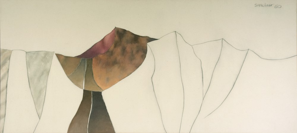
- Partially painted foothills landscape; bottom two thirds is a series of irregular vertical shapes indicating foothills; left of centre a road cuts through a valley disappearing over the horizon; reds and browns beside distant highway; 2 grey shapes at left of painting; top third is blank excep…
1 image
- Title
- Canada Classic: Mountain Muscle
- Date
- 1980
- Medium
- aquatec stain on raw cotton
- Dimensions
- 93.9 x 205.7 cm
- Description
- Partially painted foothills landscape; bottom two thirds is a series of irregular vertical shapes indicating foothills; left of centre a road cuts through a valley disappearing over the horizon; reds and browns beside distant highway; 2 grey shapes at left of painting; top third is blank except for signature and date.
- Credit
- Purchased from Wynick/Tuck Gallery, Toronto, 1990
- Catalogue Number
- SiR.05.10
Images
This material is presented as originally created; it may contain outdated cultural descriptions and
potentially offensive content.
Read more.
- Date
- 1983
- Medium
- watercolour on paper
- Catalogue Number
- SiR.05.02
- Description
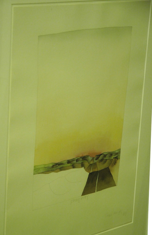
- Big sky scene with road through badlands; top 3/4 is sky, very delicately coloured, slight reddish tint at horizon off into yellow and a very slight blue tinge at the top; a brown road with a white stripe down the centre undulates through green topped badlands; blc is white with pencil lines indica…
1 image
- Title
- Forced Entry
- Date
- 1983
- Medium
- watercolour on paper
- Dimensions
- 60.4 x 45.5 cm
- Description
- Big sky scene with road through badlands; top 3/4 is sky, very delicately coloured, slight reddish tint at horizon off into yellow and a very slight blue tinge at the top; a brown road with a white stripe down the centre undulates through green topped badlands; blc is white with pencil lines indicating side of mesa; the picture is outlined with pencil;
- Credit
- Purchased from Wynick/Tuck Gallery, Toronto, 1990
- Catalogue Number
- SiR.05.02
Images
This material is presented as originally created; it may contain outdated cultural descriptions and
potentially offensive content.
Read more.
[Grande Prairie 83M - Alta.]
https://archives.whyte.org/en/permalink/catalogue24065
- Medium
- Library - Maps and blueprints (unannotated; published)
- Map
- Published Date
- 1964
- Publisher
- Department of Mines and Technical Surveys
- Call Number
- NTS
- 83M
- Publisher
- Department of Mines and Technical Surveys
- Published Date
- 1964
- Physical Description
- Colour
- Scale
- Scale: 1:250,000
- Relief: Contour interval 100 ft.
- Subjects
- Grande Prairie 83M - Alta.
- Notes
- National Topographic System
- Accession Number
- 7000
- Call Number
- NTS
- 83M
- Collection
- Archives Library
This material is presented as originally created; it may contain outdated cultural descriptions and
potentially offensive content.
Read more.
[Grande Prairie 83NW, Alta.]
https://archives.whyte.org/en/permalink/catalogue24183
- Medium
- Library - Maps and blueprints (unannotated; published)
- Map
- Published Date
- 1973
- Publisher
- Department of Energy, Mines and Resources
- Call Number
- NTS
- 83NW
- Publisher
- Department of Energy, Mines and Resources
- Published Date
- 1973
- Scale
- Scale: 1:500,000
- Hypsometric tints
- Subjects
- Grande Prairie
- Alberta
- Notes
- National Topographic System
- Accession Number
- 7000
- Call Number
- NTS
- 83NW
- Collection
- Archives Library
This material is presented as originally created; it may contain outdated cultural descriptions and
potentially offensive content.
Read more.
- Date
- 1977
- Medium
- watercolour on paper
- Catalogue Number
- SiR.05.07
- Description
- Small landscape (5.5x6.5) in molded plastic frame; top two thirds is sky near horizon medium blue deepening to very dark at top of picture; foreground has various shapes indicating hills and fields of colours ranging in the light browns and greens to white.
- Title
- Hill Slipped
- Date
- 1977
- Medium
- watercolour on paper
- Dimensions
- 8.8 x 8.8 cm
- Description
- Small landscape (5.5x6.5) in molded plastic frame; top two thirds is sky near horizon medium blue deepening to very dark at top of picture; foreground has various shapes indicating hills and fields of colours ranging in the light browns and greens to white.
- Credit
- Purchased from Wynick/Tuck Gallery, Toronto, 1990
- Catalogue Number
- SiR.05.07
This material is presented as originally created; it may contain outdated cultural descriptions and
potentially offensive content.
Read more.
Homestead map of Manitoba, Saskatchewan, and Alberta
https://archives.whyte.org/en/permalink/catalogue24576
- Medium
- Library - Maps and blueprints (unannotated; published)
- Map
- Published Date
- 1916
- Publisher
- Dept. of the Interior
- Call Number
- C11-6.1(a)
- Publisher
- Dept. of the Interior
- Published Date
- 1916
- Scale
- 35 miles to 1 inch
- Subjects
- Canada - Prairie Region
- Notes
- Shows the number of quarter sections available for homestead entry in each township
- Accession Number
- 576
- Call Number
- C11-6.1(a)
- Collection
- Archives Library
This material is presented as originally created; it may contain outdated cultural descriptions and
potentially offensive content.
Read more.
Map of Manitoba's northland
https://archives.whyte.org/en/permalink/catalogue24585
- Medium
- Library - Maps and blueprints (unannotated; published)
- Map
- Publisher
- Department of Tourism and Recreation
- Call Number
- C11-6.7
- Publisher
- Department of Tourism and Recreation
- Scale
- 1 inch - 20 miles (approx)
- Subjects
- Canada - Prairie Region
- Notes
- Shows tourist facilities, historic water routes, canoe routes
- Samuel Hearne's Journeys
- Legend on reverse side of map
- Accession Number
- 6500
- Call Number
- C11-6.7
- Collection
- Archives Library
This material is presented as originally created; it may contain outdated cultural descriptions and
potentially offensive content.
Read more.
Map showing exploration between Lakes Winnipeg, Manitoba and Winnipegosis
https://archives.whyte.org/en/permalink/catalogue24597
- Medium
- Library - Maps and blueprints (unannotated; published)
- Map
- Published Date
- February 1901
- Publisher
- Department of the Interior
- Call Number
- C11-6.20
- Publisher
- Department of the Interior
- Published Date
- February 1901
- Scale
- 6 miles - 1 inch
- Subjects
- Canada - Prairie Region
- Manitoba
- Notes
- To accompany the report of Thos. Turnbull D.L.S.
- Accession Number
- 400
- Call Number
- C11-6.20
- Collection
- Archives Library
This material is presented as originally created; it may contain outdated cultural descriptions and
potentially offensive content.
Read more.