Narrow Results By
Airdrie, Alberta
https://archives.whyte.org/en/permalink/artifactlac.05.24
- Date
- 1957
- Medium
- watercolour on paper
- Catalogue Number
- LaC.05.24
- Description
- General colour: blue grey, brown, pink. Two elevators stand at the right side on the horizon. A train chugs past on the left. The foreround is brown fields - a fence appears from the left. The sky fills the upper two thirds and is spotted with clouds.
- Title
- Airdrie, Alberta
- Date
- 1957
- Medium
- watercolour on paper
- Dimensions
- 22.8 x 27.8 cm
- Description
- General colour: blue grey, brown, pink. Two elevators stand at the right side on the horizon. A train chugs past on the left. The foreround is brown fields - a fence appears from the left. The sky fills the upper two thirds and is spotted with clouds.
- Credit
- Gift of Peter and Judith Jekill, Calgary, 1973
- Catalogue Number
- LaC.05.24
This material is presented as originally created; it may contain outdated cultural descriptions and
potentially offensive content.
Read more.
Alberta, Saskatchewan
https://archives.whyte.org/en/permalink/catalogue24580
- Medium
- Library - Maps and blueprints (unannotated; published)
- Map
- Published Date
- 1964
- Publisher
- Royal Canadian Geographical Society
- Call Number
- C11-6.2
- Publisher
- Royal Canadian Geographical Society
- Published Date
- 1964
- Scale
- 32 miles (approx) to 1 inch
- Subjects
- Canada - Prairie Region
- Accession Number
- 495
- Call Number
- C11-6.2
- Collection
- Archives Library
This material is presented as originally created; it may contain outdated cultural descriptions and
potentially offensive content.
Read more.
Alberta, Saskatchewan, Manitoba
https://archives.whyte.org/en/permalink/catalogue24575
- Medium
- Library - Maps and blueprints (unannotated; published)
- Map
- Published Date
- 1973
- Publisher
- Dept. of Energy, Mines and Resources
- Call Number
- C11-6.1
- Publisher
- Dept. of Energy, Mines and Resources
- Published Date
- 1973
- Scale
- 2 inch - 32 miles
- Subjects
- Canada - Prairie Region
- Accession Number
- 700
- Call Number
- C11-6.1
- Collection
- Archives Library
This material is presented as originally created; it may contain outdated cultural descriptions and
potentially offensive content.
Read more.
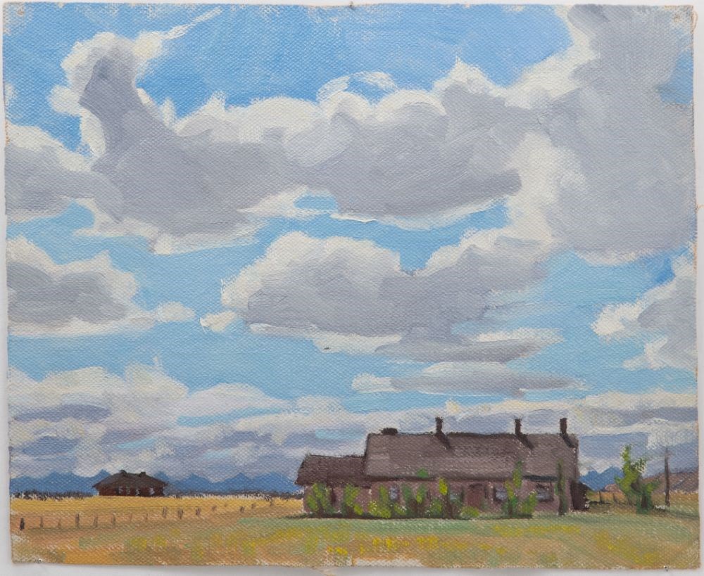
- Date
- 1944
- Medium
- oil on canvas
- Catalogue Number
- WyC.01.058
- Description
- House in foreground, big sky with clouds, in Fort Macleod area.
1 image
- Title
- Fort MacLeod
- Date
- 1944
- Medium
- oil on canvas
- Dimensions
- 22.8 x 28.0 cm
- Description
- House in foreground, big sky with clouds, in Fort Macleod area.
- Subject
- landscape
- prairie
- architecture, rural
- Credit
- Gift of Catharine Robb Whyte, O. C., Banff, 1979
- Catalogue Number
- WyC.01.058
Images
This material is presented as originally created; it may contain outdated cultural descriptions and
potentially offensive content.
Read more.
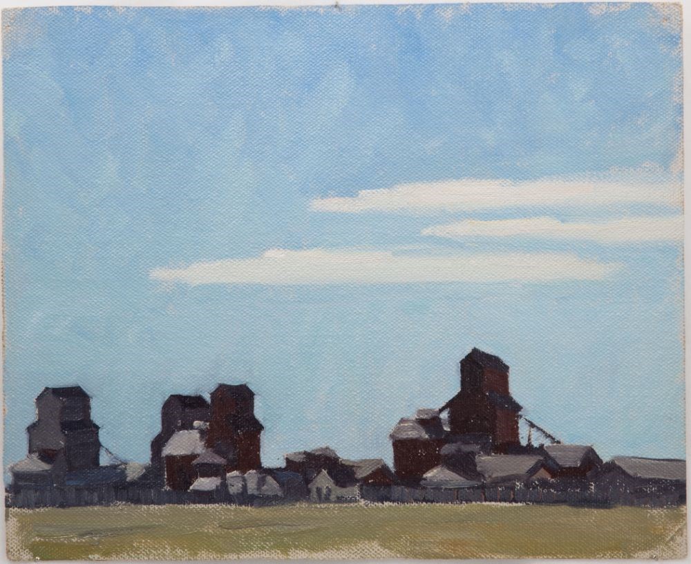
- Date
- 1944
- Medium
- oil on canvas
- Catalogue Number
- WyC.01.059
- Description
- Grain elevators on prairie in Fort Macleod area.
1 image
- Title
- Fort MacLeod
- Date
- 1944
- Medium
- oil on canvas
- Dimensions
- 22.8 x 28.0 cm
- Description
- Grain elevators on prairie in Fort Macleod area.
- Credit
- Gift of Catharine Robb Whyte, O. C., Banff, 1979
- Catalogue Number
- WyC.01.059
Images
This material is presented as originally created; it may contain outdated cultural descriptions and
potentially offensive content.
Read more.
Homestead map of Manitoba, Saskatchewan, and Alberta
https://archives.whyte.org/en/permalink/catalogue24576
- Medium
- Library - Maps and blueprints (unannotated; published)
- Map
- Published Date
- 1916
- Publisher
- Dept. of the Interior
- Call Number
- C11-6.1(a)
- Publisher
- Dept. of the Interior
- Published Date
- 1916
- Scale
- 35 miles to 1 inch
- Subjects
- Canada - Prairie Region
- Notes
- Shows the number of quarter sections available for homestead entry in each township
- Accession Number
- 576
- Call Number
- C11-6.1(a)
- Collection
- Archives Library
This material is presented as originally created; it may contain outdated cultural descriptions and
potentially offensive content.
Read more.
Map of Manitoba's northland
https://archives.whyte.org/en/permalink/catalogue24585
- Medium
- Library - Maps and blueprints (unannotated; published)
- Map
- Publisher
- Department of Tourism and Recreation
- Call Number
- C11-6.7
- Publisher
- Department of Tourism and Recreation
- Scale
- 1 inch - 20 miles (approx)
- Subjects
- Canada - Prairie Region
- Notes
- Shows tourist facilities, historic water routes, canoe routes
- Samuel Hearne's Journeys
- Legend on reverse side of map
- Accession Number
- 6500
- Call Number
- C11-6.7
- Collection
- Archives Library
This material is presented as originally created; it may contain outdated cultural descriptions and
potentially offensive content.
Read more.
Map showing exploration between Lakes Winnipeg, Manitoba and Winnipegosis
https://archives.whyte.org/en/permalink/catalogue24597
- Medium
- Library - Maps and blueprints (unannotated; published)
- Map
- Published Date
- February 1901
- Publisher
- Department of the Interior
- Call Number
- C11-6.20
- Publisher
- Department of the Interior
- Published Date
- February 1901
- Scale
- 6 miles - 1 inch
- Subjects
- Canada - Prairie Region
- Manitoba
- Notes
- To accompany the report of Thos. Turnbull D.L.S.
- Accession Number
- 400
- Call Number
- C11-6.20
- Collection
- Archives Library
This material is presented as originally created; it may contain outdated cultural descriptions and
potentially offensive content.
Read more.
Mossy Portage Sheet showing lands disposed of
https://archives.whyte.org/en/permalink/catalogue21440
- Subjects
- Canada - Prairie Region
- Manitoba
- Notes
- Sectional map
- References: Trails, Trails surveyed, Post Offices, Railway Stations, Range numbers, Township numbers
- Accession Number
- 400
- Call Number
- C11-6.8
- Collection
- Archives Library
This material is presented as originally created; it may contain outdated cultural descriptions and
potentially offensive content.
Read more.
Official highway map of Saskatchewan
https://archives.whyte.org/en/permalink/catalogue24584
- Medium
- Library - Maps and blueprints (unannotated; published)
- Map
- Published Date
- 1971
- Publisher
- Dept. of Highways and Transportation
- Call Number
- C11-6.6
- Publisher
- Dept. of Highways and Transportation
- Published Date
- 1971
- Scale
- 22 miles - 1 inch
- Subjects
- Canada - Prairie Region
- Accession Number
- 3000
- Call Number
- C11-6.6
- Collection
- Archives Library
This material is presented as originally created; it may contain outdated cultural descriptions and
potentially offensive content.
Read more.