Narrow Results By
Geographic Board of Canada Map
https://archives.whyte.org/en/permalink/catalogue24354
- Medium
- Library - Maps and blueprints (unannotated; published)
- Map
- Published Date
- 1927
- Publisher
- Geographic Board of Canada
- Call Number
- C6-7.5(a)
- Publisher
- Geographic Board of Canada
- Published Date
- 1927
- Scale
- 35 miles to 1 inch
- Subjects
- Alberta
- Notes
- Illustrating "Place Names of Alberta"
- Accession Number
- 576
- Call Number
- C6-7.5(a)
- Collection
- Archives Library
This material is presented as originally created; it may contain outdated cultural descriptions and
potentially offensive content.
Read more.
- Medium
- Library - Maps and blueprints (unannotated; published)
- Map
- Published Date
- 1927
- Publisher
- Dept. of the Interior, Ottawa
- Call Number
- C9-1.2
- Publisher
- Dept. of the Interior, Ottawa
- Published Date
- 1927
- Physical Description
- 1 map: col
- Scale
- Scale: 12 1/2 miles: 1 inch
- Subjects
- Alberta
- Accession Number
- 400
- Call Number
- C9-1.2
- Collection
- Archives Library
This material is presented as originally created; it may contain outdated cultural descriptions and
potentially offensive content.
Read more.
Sotvel's map of Alberta
https://archives.whyte.org/en/permalink/catalogue24412
- Medium
- Library - Maps and blueprints (unannotated; published)
- Map
- Published Date
- 1922
- Publisher
- Winnipeg : Stovel
- Call Number
- C9-1.22
- Publisher
- Winnipeg : Stovel
- Published Date
- 1922
- Physical Description
- 1 map : col
- Scale
- Scale: 2 3/4 inches = 40 miles
- Subjects
- Alberta
- Notes
- Shows Alberta from U.S. border to north of Lesser Slave Lake
- Accession Number
- 7687
- Call Number
- C9-1.22
- Collection
- Archives Library
This material is presented as originally created; it may contain outdated cultural descriptions and
potentially offensive content.
Read more.
[Chipewyan, Alberta] Topographical Survey
https://archives.whyte.org/en/permalink/catalogue24413
- Medium
- Library - Maps and blueprints (unannotated; published)
- Map
- Published Date
- 1929
- Publisher
- Dept. of the Interior
- Call Number
- C9-2.1
- Publisher
- Dept. of the Interior
- Published Date
- 1929
- Physical Description
- 1 map : col
- Scale
- Scale: 4 miles: 1 inch
- Relief: Spot heights
- Subjects
- Chipewyan, Alberta
- Accession Number
- 400
- Call Number
- C9-2.1
- Collection
- Archives Library
This material is presented as originally created; it may contain outdated cultural descriptions and
potentially offensive content.
Read more.
[Boundary Between Alberta and B.C.] Preliminary Topographical Maps
https://archives.whyte.org/en/permalink/catalogue24670
- Medium
- Library - Maps and blueprints (unannotated; published)
- Map
- Published Date
- 1924
- Publisher
- Dept. of the Interior
- Call Number
- C3-9.34, 36, 37, 38, 40, 49, 51, 52, 53, 54, 55
- Publisher
- Dept. of the Interior
- Published Date
- 1924
- Physical Description
- 11 maps : black and white
- Scale
- Scale: 1:50,000
- Accession Number
- 718
- Call Number
- C3-9.34, 36, 37, 38, 40, 49, 51, 52, 53, 54, 55
- Collection
- Archives Library
This material is presented as originally created; it may contain outdated cultural descriptions and
potentially offensive content.
Read more.
Geological Survey
https://archives.whyte.org/en/permalink/catalogue21459
- Medium
- Library - Book (including soft-cover and pamphlets)
- Map
- Published Date
- 1925
- Publisher
- Dept. of Mines
- Call Number
- C7-2.2, -7.2
- Publisher
- Dept. of Mines
- Published Date
- 1925
- Physical Description
- 1 map : black and white
- Subjects
- Wainwright-Vermilion Area, Alberta
- Accession Number
- 400
- Call Number
- C7-2.2, -7.2
- Collection
- Archives Library
This material is presented as originally created; it may contain outdated cultural descriptions and
potentially offensive content.
Read more.
Geographic Board of Canada Map
https://archives.whyte.org/en/permalink/catalogue23421
- Medium
- Library - Maps and blueprints (unannotated; published)
- Map
- Published Date
- 1927
- Publisher
- Geographic Board of Canada
- Call Number
- C6-7.5(a)
- Publisher
- Geographic Board of Canada
- Published Date
- 1927
- Scale
- 35 miles to 1 inch
- Subjects
- Alberta
- Notes
- Illustrating "Place Names of Alberta"
- Accession Number
- 576
- Call Number
- C6-7.5(a)
- Collection
- Archives Library
This material is presented as originally created; it may contain outdated cultural descriptions and
potentially offensive content.
Read more.
- Medium
- Library - Book (including soft-cover and pamphlets)
- Published Date
- 1925
- Publisher
- [Japan]
- Call Number
- F1090 A43 J3 1925
- Publisher
- [Japan]
- Published Date
- 1925
- Physical Description
- p. 1-81?, 250-291 : ill
- Notes
- Text in Japanese
- Call Number
- F1090 A43 J3 1925
- Collection
- Alpine Club of Canada Library
This material is presented as originally created; it may contain outdated cultural descriptions and
potentially offensive content.
Read more.
- Date
- 1925
- Material
- fibre
- Catalogue Number
- 108.04.1103 a,b
- Description
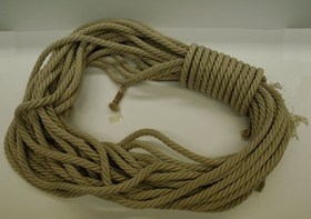
- (a) Long silk climbing rope, looped and coiled. (b) Original cardboard box with ACC note regarding useMade in Japan.
1 image
- Title
- Climbing Rope
- Date
- 1925
- Material
- fibre
- Description
- (a) Long silk climbing rope, looped and coiled. (b) Original cardboard box with ACC note regarding useMade in Japan.
- Credit
- Gift of Alpine Club of Canada, Canmore, 1973
- Catalogue Number
- 108.04.1103 a,b
Images
This material is presented as originally created; it may contain outdated cultural descriptions and
potentially offensive content.
Read more.
Report of the Commission Appointed to Delimit the Boundary between the Provinces of Alberta and British Columbia - Part II - from 1917 to 1921
https://archives.whyte.org/en/permalink/catalogue24922
- Medium
- Library - Book (including soft-cover and pamphlets)
- Published Date
- 1923
- Author
- Alberta and British Columbia Boundary Commission
- Publisher
- Ottawa : Kings Printer
- Call Number
- 03.2 Al1ab A Atlas oversize copy 2 Part II 1917-1921
- 03.2 Al1ab A Atlas oversize and report copy 3 Part II 1917-1921
- Responsibility
- R.W. Cautley
- J.N Wallace
- A.O. Wheeler
- Publisher
- Ottawa : Kings Printer
- Published Date
- 1923
- Physical Description
- 1 atlas : illustrations ; 1 report
- Subjects
- Monuments and historic markers
- Surveys
- Boundaries
- Alberta
- British Columbia
- British Columbia - Boundaries
- British Columbia - Surveys and Mapping
- Alberta - B.C. Boundary
- Alberta - Boundaries
- Alberta British Columbia Boundary Commission
- Wheeler, Arthur Oliver
- Cautley, Richard William
- Wallace, James Nevin
- Atlases
- Maps
- Notes
- Atlas and report
- Accession Number
- 7202
- 8114
- Call Number
- 03.2 Al1ab A Atlas oversize copy 2 Part II 1917-1921
- 03.2 Al1ab A Atlas oversize and report copy 3 Part II 1917-1921
- Collection
- Archives Library
This material is presented as originally created; it may contain outdated cultural descriptions and
potentially offensive content.
Read more.


