Narrow Results By
[Bearberry 820/15 West, Alberta]
https://archives.whyte.org/en/permalink/catalogue23487
- Medium
- Library - Maps and blueprints (unannotated; published)
- Map
- Published Date
- 1937
- Publisher
- Dept. of Mines and Technical Surveys
- Call Number
- NTS
- 820/15W
- Publisher
- Dept. of Mines and Technical Surveys
- Published Date
- 1937
- Physical Description
- 1 map : black and white
- Scale
- Scale: 1:50,000
- Relief: Contour interval 100'
- Notes
- National Topographic System
- Call Number
- NTS
- 820/15W
- Collection
- Archives Library
This material is presented as originally created; it may contain outdated cultural descriptions and
potentially offensive content.
Read more.
[Bragg Creek 82J/15 East, Alberta]
https://archives.whyte.org/en/permalink/catalogue23517
- Medium
- Library - Maps and blueprints (unannotated; published)
- Map
- Published Date
- 1939
- Publisher
- Dept. of Mines and Technical Surveys
- Call Number
- NTS
- 82J/15E
- Publisher
- Dept. of Mines and Technical Surveys
- Published Date
- 1939
- Physical Description
- 1 map : black and white
- Scale
- Scale: 1:50,000
- Relief: Contour interval 100'
- Subjects
- Bragg Creek
- Alberta
- Notes
- National Topographic System
- Call Number
- NTS
- 82J/15E
- Collection
- Archives Library
This material is presented as originally created; it may contain outdated cultural descriptions and
potentially offensive content.
Read more.
[Callum Creek 82G/16 East, Alberta]
https://archives.whyte.org/en/permalink/catalogue23528
- Medium
- Library - Maps and blueprints (unannotated; published)
- Map
- Published Date
- 1943
- Publisher
- Dept. of Mines and Technical Surveys
- Call Number
- NTS
- 82G/16E
- Publisher
- Dept. of Mines and Technical Surveys
- Published Date
- 1943
- Physical Description
- 1 map : black and white
- Scale
- Scale: 1:50,000
- Relief: Contour interval 100'
- Subjects
- Callum Creek
- Alberta
- Notes
- National Topographic System
- Call Number
- NTS
- 82G/16E
- Collection
- Archives Library
This material is presented as originally created; it may contain outdated cultural descriptions and
potentially offensive content.
Read more.
Club Meeting Minutes and Reports
https://archives.whyte.org/en/permalink/descriptions57991
- Part Of
- Alpine Club of Canada fonds
- Scope & Content
- Sub-series consists of the meeting minutes and reports of the Alpine Club of Canada between 1913 and 2011. Records pertain to meetings of the Executive Committee of the ACC, as well as the Executives of the various sections of the ACC, including the Banff Section, the Calgary Section, the Edmonton …
- Date Range
- 1913-1930
- ca.1937-2008
- 2011
- Reference Code
- M200 / I / A
- Description Level
- 4 / Sub-series
- GMD
- Textual record
- Organization record
- Part Of
- Alpine Club of Canada fonds
- Description Level
- 4 / Sub-series
- Fonds Number
- M200
- V14
- S6
- Series
- M200 / I: Administrative Records
- Sous-Fonds
- M200
- Sub-Series
- M200 / I / A: Club Meeting Minutes and Reports
- Accession Number
- accn. 2023.06
- accn. 5343
- accn. 2017.8658
- accn. 6376
- accn. 6375
- accn. 5465
- accn. 6470
- accn. 8002
- accn. 5634
- accn. 6765
- accn. 2023.51
- accn. 2023.01
- accn. 2023.11
- accn. 2014.8293
- Reference Code
- M200 / I / A
- Date Range
- 1913-1930
- ca.1937-2008
- 2011
- Physical Description
- 80 cm of textual records
- Scope & Content
- Sub-series consists of the meeting minutes and reports of the Alpine Club of Canada between 1913 and 2011. Records pertain to meetings of the Executive Committee of the ACC, as well as the Executives of the various sections of the ACC, including the Banff Section, the Calgary Section, the Edmonton Section and others. Records also include the Annual General Meeting minutes of the ACC during this time period. Sub-series is arranged chronologically.
- Notes
- See file-level entries for inventories of club meeting minutes and reports.
- Name Access
- Alpine Club of Canada
- Subject Access
- Administration
- Alberta
- Alpine Club of Canada
- Club
- Record keeping
- Records
- Report
- Organizations
- Geographic Access
- Canada
- Canadian Rocky Mountains
- Rocky Mountains
- Alberta
- British Columbia
- Ontario
- Saskatchewan
- Manitoba
- Banff
- Banff, AB
- Banff, Alberta
- Calgary
- Calgary, AB
- Calgary, Alberta
- Edmonton
- Edmonton, AB
- Vancouver
- Vancouver, BC
- Vancouver Island
- Vancouver Island, British Columbia
- Victoria
- Victoria, British Columbia
- Victoria, BC
- Ottawa
- St. Boniface
- Access Restrictions
- Restrictions may apply
- Reproduction Restrictions
- Contains personal information
- Language
- English
- French
- Title Source
- Title Based on contents of sub-series
- Processing Status
- Processed
This material is presented as originally created; it may contain outdated cultural descriptions and
potentially offensive content.
Read more.
[Cowley 82G/9 East, Alberta]
https://archives.whyte.org/en/permalink/catalogue23562
- Medium
- Library - Maps and blueprints (unannotated; published)
- Map
- Published Date
- 1943
- Publisher
- Dept. of Mines and Technical Surveys
- Call Number
- NTS
- 82G/9E
- Publisher
- Dept. of Mines and Technical Surveys
- Published Date
- 1943
- Physical Description
- 1 map : black and white
- Scale
- Scale: 1:50,000
- Relief: Contour interval 100'
- Notes
- National Topographic System
- Call Number
- NTS
- 82G/9E
- Collection
- Archives Library
This material is presented as originally created; it may contain outdated cultural descriptions and
potentially offensive content.
Read more.
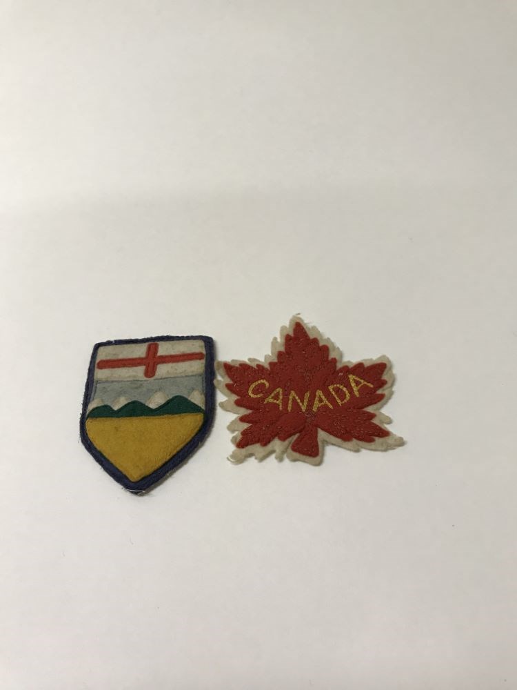
- Date
- 1940 – 1960
- Material
- fibre
- Catalogue Number
- 105.02.1060 a,b
- Description
- Alberta and Canada small felt crests. (a) 7.5 x 5.5; shield-shaped, stylized Alberta crest with yellow field, green hills, white mountains, blue sky and a red, rectangular cross on white (b) 7.2 x 7.8 maple leaf shape, red body on white background with "CANADA" in yellow stitched across centre.
1 image
- Title
- Crest
- Date
- 1940 – 1960
- Material
- fibre
- Description
- Alberta and Canada small felt crests. (a) 7.5 x 5.5; shield-shaped, stylized Alberta crest with yellow field, green hills, white mountains, blue sky and a red, rectangular cross on white (b) 7.2 x 7.8 maple leaf shape, red body on white background with "CANADA" in yellow stitched across centre.
- Credit
- Gift of Unknown, 1968
- Catalogue Number
- 105.02.1060 a,b
Images
This material is presented as originally created; it may contain outdated cultural descriptions and
potentially offensive content.
Read more.
[Deep Valley Creek South, Alberta]
https://archives.whyte.org/en/permalink/catalogue23579
- Medium
- Library - Maps and blueprints (unannotated; published)
- Map
- Published Date
- 1947
- Publisher
- Dept. of Mines & Technical Survey
- Call Number
- NTS
- 82K/4E
- Publisher
- Dept. of Mines & Technical Survey
- Published Date
- 1947
- Scale
- Scale: 1:50,000
- Subjects
- Deep Valley Creek
- Alberta
- Notes
- National Topographic System
- Accession Number
- 12000
- Call Number
- NTS
- 82K/4E
- Collection
- Archives Library
This material is presented as originally created; it may contain outdated cultural descriptions and
potentially offensive content.
Read more.
[Deep Valley Creek South, Alberta]
https://archives.whyte.org/en/permalink/catalogue23580
- Medium
- Library - Maps and blueprints (unannotated; published)
- Map
- Published Date
- 1947
- Publisher
- Dept. of Mines & Technical Survey
- Call Number
- NTS
- 83K/4W
- Publisher
- Dept. of Mines & Technical Survey
- Published Date
- 1947
- Scale
- Scale: 1:50,000
- Subjects
- Deep Valley Creek
- Alberta
- Notes
- National Topographic System
- Accession Number
- 12000
- Call Number
- NTS
- 83K/4W
- Collection
- Archives Library
This material is presented as originally created; it may contain outdated cultural descriptions and
potentially offensive content.
Read more.
[Dyson Creek 82J/10 East, Alberta]
https://archives.whyte.org/en/permalink/catalogue23597
- Medium
- Library - Maps and blueprints (unannotated; published)
- Map
- Published Date
- 1942
- Publisher
- Dept. of Mines and Technical Surveys
- Call Number
- NTS
- 82J/10E
- Publisher
- Dept. of Mines and Technical Surveys
- Published Date
- 1942
- Physical Description
- 1 map : black and white
- Scale
- Scale: 1:50,000
- Relief: Contour interval 100'
- Subjects
- Dyson Creek
- Alberta
- Notes
- National Topographic System
- Call Number
- NTS
- 82J/10E
- Collection
- Archives Library
This material is presented as originally created; it may contain outdated cultural descriptions and
potentially offensive content.
Read more.
[Fallentimber 820/10 East, Alberta]
https://archives.whyte.org/en/permalink/catalogue23610
- Medium
- Library - Maps and blueprints (unannotated; published)
- Map
- Published Date
- 1937
- Publisher
- Dept. of Mines and Technical Surveys
- Call Number
- NTS
- 820/10E
- Publisher
- Dept. of Mines and Technical Surveys
- Published Date
- 1937
- Physical Description
- 1 map : black and white
- Scale
- Scale: 1:50,000
- Relief: Contour interval 100'
- Subjects
- Fallentimber
- Alberta
- Notes
- National Topographic System
- Call Number
- NTS
- 820/10E
- Collection
- Archives Library
This material is presented as originally created; it may contain outdated cultural descriptions and
potentially offensive content.
Read more.