Narrow Results By
(a): Topographical sheets|(b): Original map
https://archives.whyte.org/en/permalink/catalogue24654
- Medium
- Library - Maps and blueprints (unannotated; published)
- Map
- Published Date
- 1889
- Publisher
- Dept. of the Interior
- Call Number
- C3-8.14 (a)
- C3-8.14 (b)
- Publisher
- Dept. of the Interior
- Published Date
- 1889
- Scale
- Scale:1:40,000
- Relief: Contour interval 100 ft.
- Subjects
- Anthracite
- Notes
- (b): 8 dup in map room
- Accession Number
- 675
- 400
- 3069
- Call Number
- C3-8.14 (a)
- C3-8.14 (b)
- Collection
- Archives Library
This material is presented as originally created; it may contain outdated cultural descriptions and
potentially offensive content.
Read more.
- Date
- 1915 – 1920
- Material
- metal
- Catalogue Number
- 102.05.0062
- Description
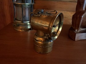
- A round brass cylinder carbide fuel container with a screw cap surmounted by a short-necked cylinder at right angles to the base which seems to be a "gas chamber." The upper cylinder has at its front end a dish reflector out of the centre of which protrudes a jet, and out of which also protrudes a …
1 image
- Title
- Carbide Lamp
- Date
- 1915 – 1920
- Material
- metal
- Dimensions
- 10.2 x 7.2 x 8.3 cm
- Description
- A round brass cylinder carbide fuel container with a screw cap surmounted by a short-necked cylinder at right angles to the base which seems to be a "gas chamber." The upper cylinder has at its front end a dish reflector out of the centre of which protrudes a jet, and out of which also protrudes a flint wheel spark generator for lighting the jet. Atop the cylinder is a tightly flanged hinged cap which can snap into place over and into an opening 2.0 x 1.5 cm oval; in front of the cap opening is a swivel device, probably for varying the flow through the jet. At the back of the cylinder is a hook mounted vertically by rivets and a clasp horizontally, for mounting the lamp on a miner's helmet. Marks:"Justrite/Pat, May 7, 1912/ Pat. Oct 28, 1913/ Pat. Nov 23, 1915/ Others Pending."
- Credit
- Gift of Catharine Robb Whyte, O. C., Banff, 1979
- Catalogue Number
- 102.05.0062
Images
This material is presented as originally created; it may contain outdated cultural descriptions and
potentially offensive content.
Read more.
Plan of the town of Anthracite. Being portions of N1/2. Section 5 and S.W. 1/4 Section 8, Tp 26, $11, W5
https://archives.whyte.org/en/permalink/catalogue21319
- Medium
- Library - Maps and blueprints (unannotated; published)
- Map
- Published Date
- 1887
- Call Number
- C4-2.3(b)
- Published Date
- 1887
- Subjects
- Anthracite
- Notes
- Stewart Avenue and Thorpe Ave.."This plan is correct and is prepared under provisions of 'The Territories Real Property Act'"
- Accession Number
- 938
- Call Number
- C4-2.3(b)
- Collection
- Archives Library
This material is presented as originally created; it may contain outdated cultural descriptions and
potentially offensive content.
Read more.
"Plan of the town of Anthracite showing location of Mine No. 1244 abandoned in 1957" (?) Plan B.
https://archives.whyte.org/en/permalink/catalogue21320
- Responsibility
- J. Vaughan D.L.S.
- Subjects
- Anthracite
- Notes
- Info on map printed backwards
- Accession Number
- 2576
- Call Number
- C4-2.3(d)
- Collection
- Archives Library
This material is presented as originally created; it may contain outdated cultural descriptions and
potentially offensive content.
Read more.
Plan shewing the C.A.C. Coy's coal land, Bow River Valley
https://archives.whyte.org/en/permalink/catalogue24880
- Medium
- Library - Maps and blueprints (unannotated; published)
- Map
- Published Date
- 1889
- Publisher
- [Anthracite? Th. C. Watts?]
- Call Number
- C14-3.3
- Responsibility
- Watts, Th. C. [?]
- Publisher
- [Anthracite? Th. C. Watts?]
- Published Date
- 1889
- Physical Description
- 1 map
- Scale
- 1 inch = 40 chains
- Subjects
- Anthracite
- Coal and coal mines
- Notes
- Sgd. Anthracite, Aug. 9th, 1889, Th.[?] C. Watts
- Call Number
- C14-3.3
- Collection
- Archives Library
This material is presented as originally created; it may contain outdated cultural descriptions and
potentially offensive content.
Read more.
Townsite map [Anthracite] N.E. Section 5
https://archives.whyte.org/en/permalink/catalogue15486
- Medium
- Library - Maps and blueprints (unannotated; published)
- Map
- Publisher
- Regional plan 573.4
- Call Number
- C4-2.3(a)
- Publisher
- Regional plan 573.4
- Scale
- Scale: 1"-200"
- Subjects
- Anthracite
- Notes
- Captain French [O'brien-fFrench] noted in area north (Fairholme Ranch) now dismantled
- Accession Number
- 938
- Call Number
- C4-2.3(a)
- Collection
- Archives Library
This material is presented as originally created; it may contain outdated cultural descriptions and
potentially offensive content.
Read more.
Townsite map, Tp 26, R 11, W 5 merid., showing Wheatley holdings, former Canmore Mines, Calgary Power, Crown Land. Privately owned.
https://archives.whyte.org/en/permalink/catalogue23282
- Scale
- Scale: 1"-400'
- Subjects
- Anthracite
- Accession Number
- 938
- Call Number
- C4-2.3(c)
- Collection
- Archives Library
This material is presented as originally created; it may contain outdated cultural descriptions and
potentially offensive content.
Read more.


