Narrow Results By
Bow Fort Site
https://archives.whyte.org/en/permalink/catalogue23331
- Medium
- Library - Maps and blueprints (unannotated; published)
- Map
- Published Date
- Jan., 1913
- Publisher
- Water Power Branch
- Call Number
- C5-6.4
- Publisher
- Water Power Branch
- Published Date
- Jan., 1913
- Scale
- 400 feet to the inch
- Notes
- (accompanies Bow River Power and Storage Investigations by M.C. Hendry 03.6)
- Accession Number
- 576
- Call Number
- C5-6.4
- Collection
- Archives Library
This material is presented as originally created; it may contain outdated cultural descriptions and
potentially offensive content.
Read more.
Bow Lake Storage Basin, Topographic Sheet No. 16
https://archives.whyte.org/en/permalink/catalogue23347
- Medium
- Library - Maps and blueprints (unannotated; published)
- Map
- Published Date
- Jan., 1913
- Publisher
- Water Power Branch
- Call Number
- C5-6.16
- Publisher
- Water Power Branch
- Published Date
- Jan., 1913
- Scale
- 400 feet to the inch
- Notes
- (accompanies Bow River Power and Storage Investigations by M.C. Hendry 03.6)
- Accession Number
- 576
- Call Number
- C5-6.16
- Collection
- Archives Library
This material is presented as originally created; it may contain outdated cultural descriptions and
potentially offensive content.
Read more.
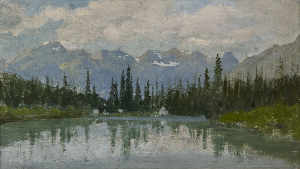
Bow River, Banff
https://archives.whyte.org/en/permalink/artifactbes.02.02
- Date
- prior to 1887
- Medium
- oil on pressed paperboard
- Catalogue Number
- BeS.02.02
- Description
- A view of the Bow River, the river covers most of the bottom half of the picture, 4 white (tents?) structures on bank, middle of picture. A line of evergreens runs through center of picture, mountains (Borgeau Range), some snow,in background, the sky is blue with lots of white clouds.
1 image
- Title
- Bow River, Banff
- Date
- prior to 1887
- Medium
- oil on pressed paperboard
- Dimensions
- 11.9 x 21.7 cm
- Description
- A view of the Bow River, the river covers most of the bottom half of the picture, 4 white (tents?) structures on bank, middle of picture. A line of evergreens runs through center of picture, mountains (Borgeau Range), some snow,in background, the sky is blue with lots of white clouds.
- Credit
- Purchased from Sotheby Parke Bernet (Canada) Ltd, Toronto, 1982
- Catalogue Number
- BeS.02.02
Images
This material is presented as originally created; it may contain outdated cultural descriptions and
potentially offensive content.
Read more.
[Bow River Basin above Calgary]
https://archives.whyte.org/en/permalink/catalogue24417
- Medium
- Library - Maps and blueprints (unannotated; published)
- Map
- Published Date
- 1912
- Publisher
- Dept. of the Interior Water Power Branch
- Call Number
- C9-3.2
- Publisher
- Dept. of the Interior Water Power Branch
- Published Date
- 1912
- Scale
- Scale: 4 miles: 1 inch
- Relief: Contour interval 500 ft.
- Subjects
- Bow River Basin
- Notes
- 2 duplicates in map room - Accn. 400
- Accession Number
- 400
- Call Number
- C9-3.2
- Collection
- Archives Library
This material is presented as originally created; it may contain outdated cultural descriptions and
potentially offensive content.
Read more.
[Bow River Forest Reserve]
https://archives.whyte.org/en/permalink/catalogue23240
- Medium
- Library - Maps and blueprints (unannotated; published)
- Map
- Published Date
- 1965
- Publisher
- Dept. of Lands, Forests
- Call Number
- C2-11.2a
- Publisher
- Dept. of Lands, Forests
- Published Date
- 1965
- Physical Description
- 1 map : col
- Scale
- Scale: 1 inch : 3 miles
- Altitude tints
- Subjects
- Bow River Forest Reserve
- Notes
- C2-11.2b - 1970 reprint - Accn. 3000
- Accession Number
- 718
- Call Number
- C2-11.2a
- Collection
- Archives Library
This material is presented as originally created; it may contain outdated cultural descriptions and
potentially offensive content.
Read more.
Cascade River Power Site, Topographic Sheet 8
https://archives.whyte.org/en/permalink/catalogue23349
- Medium
- Library - Maps and blueprints (unannotated; published)
- Map
- Published Date
- Jan., 1913
- Publisher
- Water Power Branch
- Call Number
- C5-6.18
- Publisher
- Water Power Branch
- Published Date
- Jan., 1913
- Scale
- 50 feet to the inch
- Notes
- (accompanies Bow River Power and Storage Investigations by M.C. Hendry 03.6)
- Accession Number
- 576
- Call Number
- C5-6.18
- Collection
- Archives Library
This material is presented as originally created; it may contain outdated cultural descriptions and
potentially offensive content.
Read more.
Contour Map of Bow River Basin above Calgary
https://archives.whyte.org/en/permalink/catalogue23319
- Medium
- Library - Maps and blueprints (unannotated; published)
- Map
- Published Date
- May, 1912
- Publisher
- Water Power Branch
- Call Number
- C5-6.0
- Publisher
- Water Power Branch
- Published Date
- May, 1912
- Scale
- 4 miles to the inch
- Notes
- (accompanies Bow River Power and Storage Investigations by M.C. Hendry 03.6)
- Accession Number
- 576
- Call Number
- C5-6.0
- Collection
- Archives Library
This material is presented as originally created; it may contain outdated cultural descriptions and
potentially offensive content.
Read more.
Elbow River Development
https://archives.whyte.org/en/permalink/catalogue23357
- Medium
- Library - Maps and blueprints (unannotated; published)
- Map
- Published Date
- Jan., 1913
- Publisher
- Water Power Branch
- Call Number
- C5-6.25
- Publisher
- Water Power Branch
- Published Date
- Jan., 1913
- Scale
- 750 feet to the inch
- Notes
- (accompanies Bow River Power and Storage Investigations by M.C. Hendry 03.6)
- Accession Number
- 576
- Call Number
- C5-6.25
- Collection
- Archives Library
This material is presented as originally created; it may contain outdated cultural descriptions and
potentially offensive content.
Read more.
General Plan And Development, Kananaskis Falls
https://archives.whyte.org/en/permalink/catalogue23325
- Medium
- Library - Maps and blueprints (unannotated; published)
- Map
- Published Date
- Jan., 1913
- Publisher
- Water Power Branch
- Call Number
- C5-6.1a
- Publisher
- Water Power Branch
- Published Date
- Jan., 1913
- Scale
- 80 feet to the inch
- Notes
- (accompanies the Bow River Power and Storage Investigations by M.C. Hendry 03.6)
- Accession Number
- 576
- Call Number
- C5-6.1a
- Collection
- Archives Library
This material is presented as originally created; it may contain outdated cultural descriptions and
potentially offensive content.
Read more.
Ghost River Storage Site, Topographic Sheet No. 15
https://archives.whyte.org/en/permalink/catalogue23346
- Medium
- Library - Maps and blueprints (unannotated; published)
- Map
- Published Date
- Jan., 1913
- Publisher
- Water Power Branch
- Call Number
- C5-6.15
- Publisher
- Water Power Branch
- Published Date
- Jan., 1913
- Scale
- 400 feet to the inch
- Notes
- (accompanies Bow River Power and Storage Investigations by M.C. Hendry 03.6)
- Accession Number
- 576
- Call Number
- C5-6.15
- Collection
- Archives Library
This material is presented as originally created; it may contain outdated cultural descriptions and
potentially offensive content.
Read more.