Narrow Results By
[Stuart Lake, Northern B.C.] Pre-emptor's map
https://archives.whyte.org/en/permalink/catalogue24526
- Medium
- Library - Maps and blueprints (unannotated; published)
- Map
- Published Date
- 1923
- Publisher
- Department of Lands, B.C.
- Call Number
- C10-3.4
- Publisher
- Department of Lands, B.C.
- Published Date
- 1923
- Scale
- Scale: 3 miles: 1 inch
- Relief: contour interval 200 ft.
- Subjects
- Northern British Columbia
- Stuart Lake
- Accession Number
- 295
- Call Number
- C10-3.4
- Collection
- Archives Library
This material is presented as originally created; it may contain outdated cultural descriptions and
potentially offensive content.
Read more.
Report of the Commission Appointed to Delimit the Boundary between the Provinces of Alberta and British Columbia - Part II - from 1917 to 1921
https://archives.whyte.org/en/permalink/catalogue24922
- Medium
- Library - Book (including soft-cover and pamphlets)
- Published Date
- 1923
- Author
- Alberta and British Columbia Boundary Commission
- Publisher
- Ottawa : Kings Printer
- Call Number
- 03.2 Al1ab A Atlas oversize copy 2 Part II 1917-1921
- 03.2 Al1ab A Atlas oversize and report copy 3 Part II 1917-1921
- Responsibility
- R.W. Cautley
- J.N Wallace
- A.O. Wheeler
- Publisher
- Ottawa : Kings Printer
- Published Date
- 1923
- Physical Description
- 1 atlas : illustrations ; 1 report
- Subjects
- Monuments and historic markers
- Surveys
- Boundaries
- Alberta
- British Columbia
- British Columbia - Boundaries
- British Columbia - Surveys and Mapping
- Alberta - B.C. Boundary
- Alberta - Boundaries
- Alberta British Columbia Boundary Commission
- Wheeler, Arthur Oliver
- Cautley, Richard William
- Wallace, James Nevin
- Atlases
- Maps
- Notes
- Atlas and report
- Accession Number
- 7202
- 8114
- Call Number
- 03.2 Al1ab A Atlas oversize copy 2 Part II 1917-1921
- 03.2 Al1ab A Atlas oversize and report copy 3 Part II 1917-1921
- Collection
- Archives Library
This material is presented as originally created; it may contain outdated cultural descriptions and
potentially offensive content.
Read more.
[Boundary Between Alberta and B.C.] Preliminary Topographical Maps
https://archives.whyte.org/en/permalink/catalogue24670
- Medium
- Library - Maps and blueprints (unannotated; published)
- Map
- Published Date
- 1924
- Publisher
- Dept. of the Interior
- Call Number
- C3-9.34, 36, 37, 38, 40, 49, 51, 52, 53, 54, 55
- Publisher
- Dept. of the Interior
- Published Date
- 1924
- Physical Description
- 11 maps : black and white
- Scale
- Scale: 1:50,000
- Accession Number
- 718
- Call Number
- C3-9.34, 36, 37, 38, 40, 49, 51, 52, 53, 54, 55
- Collection
- Archives Library
This material is presented as originally created; it may contain outdated cultural descriptions and
potentially offensive content.
Read more.
The Columbia unveiled : being the story of a trip, alone, in a rowboat from the source to the mouth of the Columbia River, together with a full description of the country traversed, and the rapids battled
https://archives.whyte.org/en/permalink/catalogue3569
- Medium
- Library - Book (including soft-cover and pamphlets)
- Published Date
- 1924
- Author
- Lorraine, M. J
- Publisher
- Los Angeles : Times-Mirror
- Call Number
- 02.3 C72l
- Author
- Lorraine, M. J
- Publisher
- Los Angeles : Times-Mirror
- Published Date
- 1924
- Physical Description
- 466p. : ill., map
- Subjects
- British Columbia
- Accession Number
- 1000
- Call Number
- 02.3 C72l
- Collection
- Archives Library
This material is presented as originally created; it may contain outdated cultural descriptions and
potentially offensive content.
Read more.
Report of the Commission Appointed to Delimit the Boundary between the Provinces of Alberta and British Columbia - Part III - from 1918 to 1924
https://archives.whyte.org/en/permalink/catalogue24923
- Medium
- Library - Book (including soft-cover and pamphlets)
- Published Date
- 1925
- Author
- Alberta and British Columbia Boundary Commission
- Publisher
- Ottawa : Kings Printer
- Call Number
- 03.2 Al1ab A Atlas oversize copy 2 Part III 1918-1924
- 03.2 Al1ab A Atlas oversize and report copy 3 Part III 1918-1924
- Responsibility
- R.W. Cautley
- A.O. Wheeler
- Publisher
- Ottawa : Kings Printer
- Published Date
- 1925
- Physical Description
- 1 atlas : illustrations ; 1 report
- Subjects
- Monuments and historic markers
- Surveys
- Boundaries
- Alberta
- British Columbia
- British Columbia - Boundaries
- British Columbia - Surveys and Mapping
- Alberta - B.C. Boundary
- Alberta - Boundaries
- Alberta British Columbia Boundary Commission
- Wheeler, Arthur Oliver
- Cautley, Richard William
- Wallace, James Nevin
- Atlases
- Maps
- Notes
- Atlas and report
- Accession Number
- 7202
- 8114
- Call Number
- 03.2 Al1ab A Atlas oversize copy 2 Part III 1918-1924
- 03.2 Al1ab A Atlas oversize and report copy 3 Part III 1918-1924
- Collection
- Archives Library
This material is presented as originally created; it may contain outdated cultural descriptions and
potentially offensive content.
Read more.
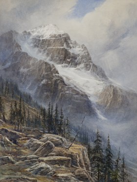
Mt. Stephan, B.C.
https://archives.whyte.org/en/permalink/artifactfrt.05.01
- Date
- 1925
- Medium
- watercolour on paper
- Catalogue Number
- FrT.05.01
- Description
- Mountain scene with rocky cliff interspersed with stands of conifers at left foreground. Large mountain [Mt. Stephen] with snow filled central gully and snow-capped peak in background. Signed “Thos W. Fripp 1925” at bottom left.
1 image
- Title
- Mt. Stephan, B.C.
- Date
- 1925
- Medium
- watercolour on paper
- Dimensions
- 51.0 x 38.0 cm
- Description
- Mountain scene with rocky cliff interspersed with stands of conifers at left foreground. Large mountain [Mt. Stephen] with snow filled central gully and snow-capped peak in background. Signed “Thos W. Fripp 1925” at bottom left.
- Subject
- mountains
- Mt. Stephen
- British Columbia
- Credit
- Gift of Rod Green, Calgary, 2021
- Catalogue Number
- FrT.05.01
Images
This material is presented as originally created; it may contain outdated cultural descriptions and
potentially offensive content.
Read more.
[British Columbia Game map] Sketch map showing game districts and regulations
https://archives.whyte.org/en/permalink/catalogue24541
- Medium
- Library - Maps and blueprints (unannotated; published)
- Map
- Published Date
- 1926
- Publisher
- Charles F. Banfield, Victoria
- Call Number
- C10-11.1
- Publisher
- Charles F. Banfield, Victoria
- Published Date
- 1926
- Scale
- Scale: 1 inch - 64 miles
- Subjects
- British Columbia
- Game map
- Notes
- Game regulations on reverse side of map
- Accession Number
- 400
- Call Number
- C10-11.1
- Collection
- Archives Library
This material is presented as originally created; it may contain outdated cultural descriptions and
potentially offensive content.
Read more.
The kicking horse trail, scenic highway from Lake Louise, Alberta to Golden, British Columbia
https://archives.whyte.org/en/permalink/catalogue19849
- Medium
- Library - Book (including soft-cover and pamphlets)
- Published Date
- 1927
- Author
- Williams, M.B.
- Publisher
- [Ottawa], [F.A. Acland, printer]
- Call Number
- 02.6 W66k PAM
1 website
- Author
- Williams, M.B.
- Responsibility
- M.B. Williams
- Publisher
- [Ottawa], [F.A. Acland, printer]
- Published Date
- 1927
- Physical Description
- 47 pages
- Subjects
- British Columbia
- Alberta
- Travel
- Abstract
- Pertains to a Canadian Rocky Mountain travel guide. With the use of both images and text, the author has been successful in compiling a guide for travelling in the Canadian Rockies. The book is written in a narrative voice, as to immerse the reader into the Canadian Rocky Mountain experience. The author cover areas and landmarks ranging from Lake Louise, Alberta to Golden, British Columbia.
- Notes
- This version contains a unique annotation on the first page dating August 4, 1927 from Fred Johnston
- Accession Number
- 2019.50
- Call Number
- 02.6 W66k PAM
- Collection
- Archives Library
- URL Notes
- The URL is linked to an interactive website in which the reader can learn more about the author and her admiration for Canada’s national parks.
Websites
This material is presented as originally created; it may contain outdated cultural descriptions and
potentially offensive content.
Read more.
[Northern Peace River Sheet] Pre-emptor's map
https://archives.whyte.org/en/permalink/catalogue24525
- Medium
- Library - Maps and blueprints (unannotated; published)
- Map
- Published Date
- 1928
- Publisher
- Department of Lands, B.C.
- Call Number
- C10-3.3
- Publisher
- Department of Lands, B.C.
- Published Date
- 1928
- Scale
- Scale: 4 miles: 1 inch
- Subjects
- British Columbia
- Northern Peace River
- Accession Number
- 495
- Call Number
- C10-3.3
- Collection
- Archives Library
This material is presented as originally created; it may contain outdated cultural descriptions and
potentially offensive content.
Read more.
[Stikine River, Northern B.C.]
https://archives.whyte.org/en/permalink/catalogue24528
- Medium
- Library - Maps and blueprints (unannotated; published)
- Map
- Published Date
- 1929
- Publisher
- Department of Lands, B.C.
- Call Number
- C10-3.6
- Publisher
- Department of Lands, B.C.
- Published Date
- 1929
- Scale
- Scale: 5 miles: 1 inch
- Relief: contour interval 500 ft.
- Subjects
- Northern British Columbia
- Stikine River
- Accession Number
- 495
- Call Number
- C10-3.6
- Collection
- Archives Library
This material is presented as originally created; it may contain outdated cultural descriptions and
potentially offensive content.
Read more.


