Narrow Results By
- Part Of
- Murray Hay fonds
- Scope & Content
- File consists of 2 cm of textual records, 43 x 28 cm, or smaller. File pertains to Murray Hay's work on various projects in Alaska, USA, specifically the Mount Roberts Tramway in Juneau and Anchorage's Olympic Bid for the 1992 Winter Olympics. File includes a map and/or illustration of the Mount Ro…
- Date Range
- ca.1980-1997
- 1996
- 1997
- Reference Code
- M570 / IV / A / 2-3
- Description Level
- 5 / File
- GMD
- Textual record
- Private record
- Map
- Part Of
- Murray Hay fonds
- Description Level
- 5 / File
- Fonds Number
- M570 / V795
- Series
- M570 / IV : Murray Hay Personal Papers
- Sous-Fonds
- M570
- Sub-Series
- M570 / IV / A : Correspondence
- Accession Number
- 2019.41
- Reference Code
- M570 / IV / A / 2-3
- Date Range
- ca.1980-1997
- 1996
- 1997
- Physical Description
- 2 cm of textual records (43 x 28 cm or smaller)
- Scope & Content
- File consists of 2 cm of textual records, 43 x 28 cm, or smaller. File pertains to Murray Hay's work on various projects in Alaska, USA, specifically the Mount Roberts Tramway in Juneau and Anchorage's Olympic Bid for the 1992 Winter Olympics. File includes a map and/or illustration of the Mount Roberts Tramway in Juneau, Alaska; handwritten correspondence between Hay and "Ms. Hunter" and the mailing slip (1997); a rough sketch of Hay's illustrations; tourism information related to the Mount Roberts Tramway; and correspondence and a draft example of the map for the Olympic Bid.
- Notes
- The Mount Roberts Tramway has been in operation since 1996.
- M570 / IV / A / 3 : date based on the potential connection between the records and the Olympic bid process for the 1992 Winter Olympics, for which Anchorage (Alyeska) submitted a bid using maps created by Murray Hay. The selection was determined in 1986.
- Records were originally filed in two envelopes, labelled: "Mt. Roberts Trmw." and "Prince William Sound - Valdez." File titles reflect this.
- Name Access
- Hay, Murray
- Subject Access
- Advertising
- Artist
- Cartography
- Discovery and travel
- Leisure
- Map
- Tourism
- Tourist information
- Travel
- Ski area
- Ski Maps
- Sports and recreation
- Winter
- Winter sports
- Olympic Games (Winter)
- Geographic Access
- Alaska
- United States of America
- Juneau
- Valdez
- Prince William Sound
- Language
- English
- Title Source
- Title based on contents of file
- Processing Status
- Processed
This material is presented as originally created; it may contain outdated cultural descriptions and
potentially offensive content.
Read more.
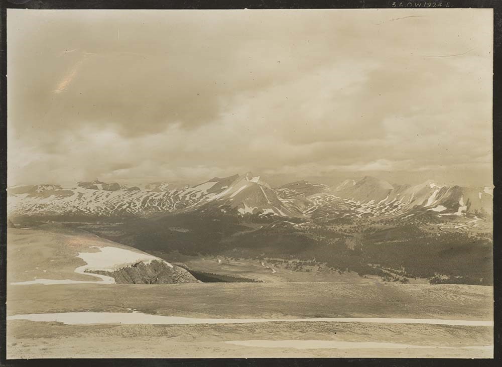
Alberta- British Columbia Boundary Survey, 1924. Volume 1 ( 10 volumes), Stations 289-294
https://archives.whyte.org/en/permalink/descriptions22843
- Part Of
- Arthur Oliver Wheeler fonds
- Scope & Content
- Includes list of stations with bearings and coordinates for each related photograph.
- Date Range
- 1924
- Reference Code
- V771 / PD -57
- Description Level
- 5 / File
2 images
- Part Of
- Arthur Oliver Wheeler fonds
- Description Level
- 5 / File
- Fonds Number
- V771
- Sous-Fonds
- V771
- Accession Number
- 8144
- Reference Code
- V771 / PD -57
- Date Range
- 1924
- Physical Description
- 1 photograph album: 27 pages
- Scope & Content
- Includes list of stations with bearings and coordinates for each related photograph.
- Subject Access
- Surveying/ Cartography
- Mountains
- Title Source
- Title taken from source.
- Processing Status
- Processed
Images
This material is presented as originally created; it may contain outdated cultural descriptions and
potentially offensive content.
Read more.
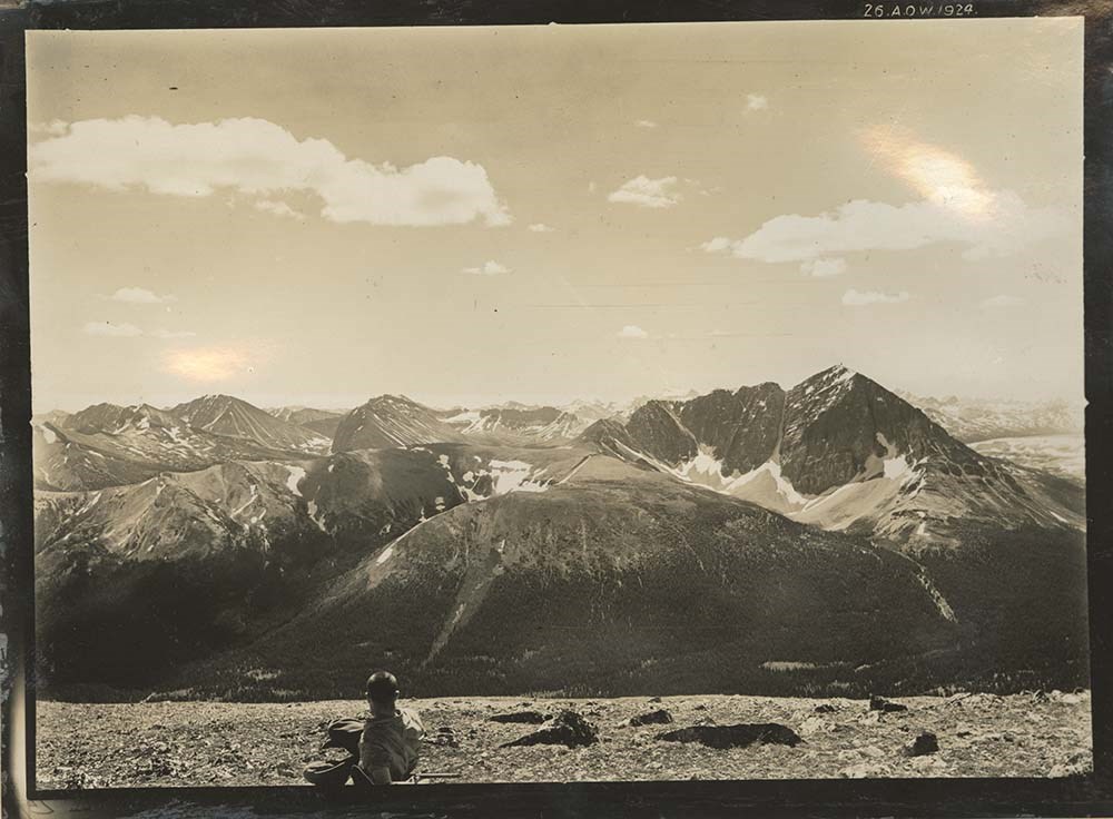
Alberta- British Columbia Boundary Survey, 1924. Volume 3 ( 10 volumes), Stations 301-306
https://archives.whyte.org/en/permalink/descriptions22845
- Part Of
- Arthur Oliver Wheeler fonds
- Scope & Content
- Includes list of stations with bearings and coordinates for each related photograph.
- Date Range
- 1924
- Reference Code
- V771 / PD -59
- Description Level
- 5 / File
1 image
- Part Of
- Arthur Oliver Wheeler fonds
- Description Level
- 5 / File
- Fonds Number
- V771
- Sous-Fonds
- V771
- Accession Number
- 8144
- Reference Code
- V771 / PD -59
- Date Range
- 1924
- Physical Description
- 1 photograph album: 28 pages
- Scope & Content
- Includes list of stations with bearings and coordinates for each related photograph.
- Subject Access
- Surveying/ Cartography
- Mountains
- Title Source
- Title taken from source.
- Processing Status
- Processed
Images

This material is presented as originally created; it may contain outdated cultural descriptions and
potentially offensive content.
Read more.
Alberta- British Columbia Boundary Survey, 1924. Volume 10 ( 10 volumes), Stations 343-349
https://archives.whyte.org/en/permalink/descriptions22852
- Part Of
- Arthur Oliver Wheeler fonds
- Scope & Content
- Includes list of stations with bearings and coordinates for each related photograph.
- Date Range
- 1924
- Reference Code
- V771 / PD -66
- Description Level
- 5 / File
1 image
- Part Of
- Arthur Oliver Wheeler fonds
- Description Level
- 5 / File
- Fonds Number
- V771
- Sous-Fonds
- V771
- Accession Number
- 8144
- Reference Code
- V771 / PD -66
- Date Range
- 1924
- Physical Description
- 1 photograph album: 28 pages
- Scope & Content
- Includes list of stations with bearings and coordinates for each related photograph.
- Subject Access
- Surveying/ Cartography
- Mountains
- Title Source
- Title taken from source.
- Processing Status
- Processed
Images

This material is presented as originally created; it may contain outdated cultural descriptions and
potentially offensive content.
Read more.
Alts Golf and Ski Resort, Japan
https://archives.whyte.org/en/permalink/descriptions54972
- Part Of
- Murray Hay fonds
- Scope & Content
- File consists of 4 prints : col. ; 22 x 15.5 cm or smaller on sheet 35 x 30 cm. FIle pertains to Murray Hay's work for Alts Golf and Ski Resort in Japan. File includes multiple prints glued/taped to a sheet of paper depicting different areas of the ski area, and is titled "Alts Golf and Ski Resort …
- Date Range
- ca. 1976 - ca. 2000
- Reference Code
- V795 / II / D / ii / 1
- Description Level
- 5 / File
- GMD
- Map
- Private record
- Part Of
- Murray Hay fonds
- Description Level
- 5 / File
- Fonds Number
- M570 / V795
- Series
- V795 / II : Unpublished Material
- Sous-Fonds
- V795
- Sub-Series
- V795 / II / D : International / ii : Miscellaneous
- Accession Number
- 2019.41
- Reference Code
- V795 / II / D / ii / 1
- GMD
- Map
- Private record
- Date Range
- ca. 1976 - ca. 2000
- Physical Description
- 4 prints : col. ; 22 x 15.5 cm or smaller on sheet 35 x 30 cm
- Scope & Content
- File consists of 4 prints : col. ; 22 x 15.5 cm or smaller on sheet 35 x 30 cm. FIle pertains to Murray Hay's work for Alts Golf and Ski Resort in Japan. File includes multiple prints glued/taped to a sheet of paper depicting different areas of the ski area, and is titled "Alts Golf and Ski Resort in the Bandai Area of Japan."
- Name Access
- Hay, Murray
- Subject Access
- Advertising
- Artist
- Ski Maps
- Map
- Cartography
- Sports and recreation
- Tourism
- Tourist information
- Travel
- Winter
- Winter sports
- Ski area
- Geographic Access
- Japan
- Language
- English
- Conservation
- Prints are taped or otherwise glued to the sheet of paper. Adhesives should be removed and alternative preservation methods used at a reasonable time to do so.
- Related Material
- M570 / III / D / ii / 2
- Creator
- Hay, Murray
- Title Source
- Title based on contents of file
- Processing Status
- Processed
This material is presented as originally created; it may contain outdated cultural descriptions and
potentially offensive content.
Read more.
An atlas of the world
https://archives.whyte.org/en/permalink/catalogue25563
- Medium
- Library - Book (including soft-cover and pamphlets)
- Published Date
- 1925
- Author
- Philip, George
- Publisher
- London : Robert Riviére & Son
- Edition
- 15
- Call Number
- 03.1 P53a
- Author
- Philip, George
- Responsibility
- Ravenstein, E. G.
- Edition
- 15
- Publisher
- London : Robert Riviére & Son
- Published Date
- 1925
- Physical Description
- 94 pages
- Series
- The Reference Library
- Subjects
- Cartography
- Maps
- Atlases
- World
- World War I
- Contents
- Section I: Maps ; Section II: Descriptive and Statistical Notes and Index
- Notes
- The HANDY VOLUME ATLAS OF THE WORLD has long enjoyed a large measure of popularity as the most complete and accurate Compendium of Geographical Information of its size published. The evidence of this continued popularity lies in the fact that, since it was first produced under the Editorship of the eminent Geographer, the late Dr. E. G. Ravenstein, no fewer than fourteen large editions have been issued. In this, the FIFTEENTH EDITION, the present Editor has endeavoured to deserve a continuance of that popularity, by making the new issue of the Atlas a complete SURVEY of POST-WAR GEOGRAPHY, exhibiting, in their natural order, the territorial changes and political changes throughout the World effected by the Peace Treaties and Agreements following the Great War. -- Excerpt from Preface, p. v
- Accession Number
- 3069A
- Call Number
- 03.1 P53a
- Collection
- Archives Library
This material is presented as originally created; it may contain outdated cultural descriptions and
potentially offensive content.
Read more.
A.O. Wheeler. Stn. 182-186 Pages 1-23, 1921; Stn.187-189 Pages 24-50, 1922. Volume 1 ( 7 volumes)
https://archives.whyte.org/en/permalink/descriptions22825
- Part Of
- Arthur Oliver Wheeler fonds
- Scope & Content
- Includes list of stations with bearings and coordinates for each related photograph. Some annotations alongside photographs. No cover page included in this set of volumes, cover pages on previous volumes describe books as an "Index to the views of the Interprovincial Boundary Survey".
- Date Range
- 1921-1922
- Reference Code
- V771 / PD -39
- Description Level
- 5 / File
2 images
- Part Of
- Arthur Oliver Wheeler fonds
- Description Level
- 5 / File
- Fonds Number
- V771
- Sous-Fonds
- V771
- Accession Number
- 8144
- Reference Code
- V771 / PD -39
- Date Range
- 1921-1922
- Physical Description
- 1 photograph album: 27 pages
- Scope & Content
- Includes list of stations with bearings and coordinates for each related photograph. Some annotations alongside photographs. No cover page included in this set of volumes, cover pages on previous volumes describe books as an "Index to the views of the Interprovincial Boundary Survey".
- Subject Access
- Surveying/ Cartography
- Mountains
- Title Source
- Title taken from source.
- Processing Status
- Processed
Images


This material is presented as originally created; it may contain outdated cultural descriptions and
potentially offensive content.
Read more.
A.O. Wheeler. Stn. 206-213, Pages 201-250,1922. Volume 5 ( 7 volumes)
https://archives.whyte.org/en/permalink/descriptions22829
- Part Of
- Arthur Oliver Wheeler fonds
- Scope & Content
- Includes list of stations with bearings and coordinates for each related photograph. No cover page included in this set of volumes, cover pages on previous volumes describe books as an "Index to the views of the Interprovincial Boundary Survey".
- Date Range
- 1922
- Reference Code
- V771 / PD -43
- Description Level
- 5 / File
3 images
- Part Of
- Arthur Oliver Wheeler fonds
- Description Level
- 5 / File
- Fonds Number
- V771
- Sous-Fonds
- V771
- Accession Number
- 8144
- Reference Code
- V771 / PD -43
- Date Range
- 1922
- Physical Description
- 1 photograph album: 27 pages
- Scope & Content
- Includes list of stations with bearings and coordinates for each related photograph. No cover page included in this set of volumes, cover pages on previous volumes describe books as an "Index to the views of the Interprovincial Boundary Survey".
- Subject Access
- Surveying/ Cartography
- Mountains
- Title Source
- Title taken from source.
- Processing Status
- Processed
Images


This material is presented as originally created; it may contain outdated cultural descriptions and
potentially offensive content.
Read more.
Apex Mountain Ski Resort
https://archives.whyte.org/en/permalink/descriptions54875
- Part Of
- Murray Hay fonds
- Scope & Content
- File consists of 1 map (1 base, 4 overlays) : col., annotations, on mylar ; 83 x 61.5 cm, and 1 print : b&w ; 25.5 x 20.5 cm. File pertains to ski maps Murray Hay created for Apex Mountain Ski Resort in Penticton, British Columbia. File includes one oversize map with four overlays (held together wi…
- Date Range
- ca.1976-ca.2000
- Reference Code
- V795 / II / A / iv / 3-4
- Description Level
- 5 / File
- GMD
- Map
- Private record
- Part Of
- Murray Hay fonds
- Description Level
- 5 / File
- Fonds Number
- M570 / V795
- Series
- V795 / II : Unpublished Material
- Sous-Fonds
- V795
- Sub-Series
- V795 / II / A : British Columbia / iv : Okanagan Area
- Accession Number
- 2019.41
- Reference Code
- V795 / II / A / iv / 3-4
- GMD
- Map
- Private record
- Date Range
- ca.1976-ca.2000
- Physical Description
- 1 map (1 base, 4 overlays) : col., annotations, on mylar ; 83 x 61.5 cm
- 1 print : b&w ; 25.5 x 20.5 cm
- Scope & Content
- File consists of 1 map (1 base, 4 overlays) : col., annotations, on mylar ; 83 x 61.5 cm, and 1 print : b&w ; 25.5 x 20.5 cm. File pertains to ski maps Murray Hay created for Apex Mountain Ski Resort in Penticton, British Columbia. File includes one oversize map with four overlays (held together with masking tape), and one print of the general ski area.
- Notes
- V795 / II / A / iv / 4 : has "16488" and "Hold" written in pencil on the masking tape.
- Name Access
- Hay, Murray
- Subject Access
- Advertising
- Art
- Artist
- Ski Maps
- Map
- Cartography
- Sports and recreation
- Tourism
- Tourist information
- Winter
- Winter sports
- Ski area
- Apex Mountain Ski Resort
- Geographic Access
- British Columbia
- Canada
- Penticton
- Language
- English
- Conservation
- The masking tape should be removed and alternative preservation methods should be considered at a reasonable time to do so.
- Creator
- Hay, Murray
- Title Source
- Title based on contents of file
- Processing Status
- Processed
This material is presented as originally created; it may contain outdated cultural descriptions and
potentially offensive content.
Read more.
Auyuittuq National Park
https://archives.whyte.org/en/permalink/descriptions54979
- Part Of
- Murray Hay fonds
- Scope & Content
- File consists of 1 painting : landscape ; 50.5 x 39.5 cm. File pertains to a map Murray Hay created of Auyuittuq National Park in Nunavut, Canada. File includes 1 colour painting of the park and surrounding area (Nunavut, Baffin Island) and one sheet of tracing paper that is annotated and taped wit…
- Date Range
- ca.1980-ca.1989
- Reference Code
- V795 / II / C / vi / 1
- Description Level
- 5 / File
- GMD
- Map
- Painting
- Private record
- Part Of
- Murray Hay fonds
- Description Level
- 5 / File
- Fonds Number
- M570 / V795
- Series
- V795 / II : Unpublished Material
- Sous-Fonds
- V795
- Sub-Series
- V795 / II / C : Canada [general] / vi : Auyuittuq National Park
- Accession Number
- 2020.03
- Reference Code
- V795 / II / C / vi / 1
- Date Range
- ca.1980-ca.1989
- Physical Description
- 1 painting : landscape ; 50.5 x 39.5 cm
- Scope & Content
- File consists of 1 painting : landscape ; 50.5 x 39.5 cm. File pertains to a map Murray Hay created of Auyuittuq National Park in Nunavut, Canada. File includes 1 colour painting of the park and surrounding area (Nunavut, Baffin Island) and one sheet of tracing paper that is annotated and taped with masking tape over the painting.
- Name Access
- Hay, Murray
- Subject Access
- Advertising
- Artist
- Map
- Cartography
- Painting
- Geography
- Tourism
- Tourist information
- Travel
- National parks and reserves
- Auyuittuq National Park
- Geographic Access
- Auyuittuq National Park
- Nunavut
- Canada
- Language
- English
- Conservation
- Masking tape should be removed and alternative preservation methods should be considered at a reasonable time to do so.
- Creator
- Hay, Murray
- Title Source
- Title based on contents of file
- Processing Status
- Processed
This material is presented as originally created; it may contain outdated cultural descriptions and
potentially offensive content.
Read more.