Narrow Results By
Alberta- British Columbia Boundary Commission. Photographs by A.O. Wheeler. Album 3.1916 [369 - 554]
https://archives.whyte.org/en/permalink/descriptions22805
- Part Of
- Arthur Oliver Wheeler fonds
- Scope & Content
- Alberta- British Columbia Boundary Commission. Photographs by A.O. Wheeler. Album 3. Includes list of stations with bearings and coordinates for each related photograph.
- Date Range
- 1916
- Reference Code
- V771 / PD -7
- Description Level
- 5 / File
1 image
- Part Of
- Arthur Oliver Wheeler fonds
- Description Level
- 5 / File
- Fonds Number
- V771
- Sous-Fonds
- V771
- Accession Number
- 8144
- Reference Code
- V771 / PD -7
- Date Range
- 1916
- Physical Description
- 1 photograph album: 190 pages 1 map affixed to second page
- Scope & Content
- Alberta- British Columbia Boundary Commission. Photographs by A.O. Wheeler. Album 3. Includes list of stations with bearings and coordinates for each related photograph.
- Subject Access
- Surveying/ Cartography
- Mountains
- Title Source
- Title taken from source.
- Processing Status
- Processed
Images
This material is presented as originally created; it may contain outdated cultural descriptions and
potentially offensive content.
Read more.
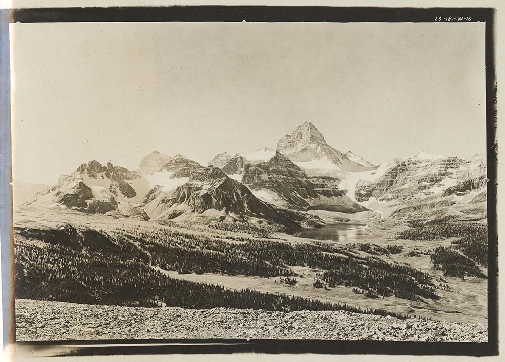
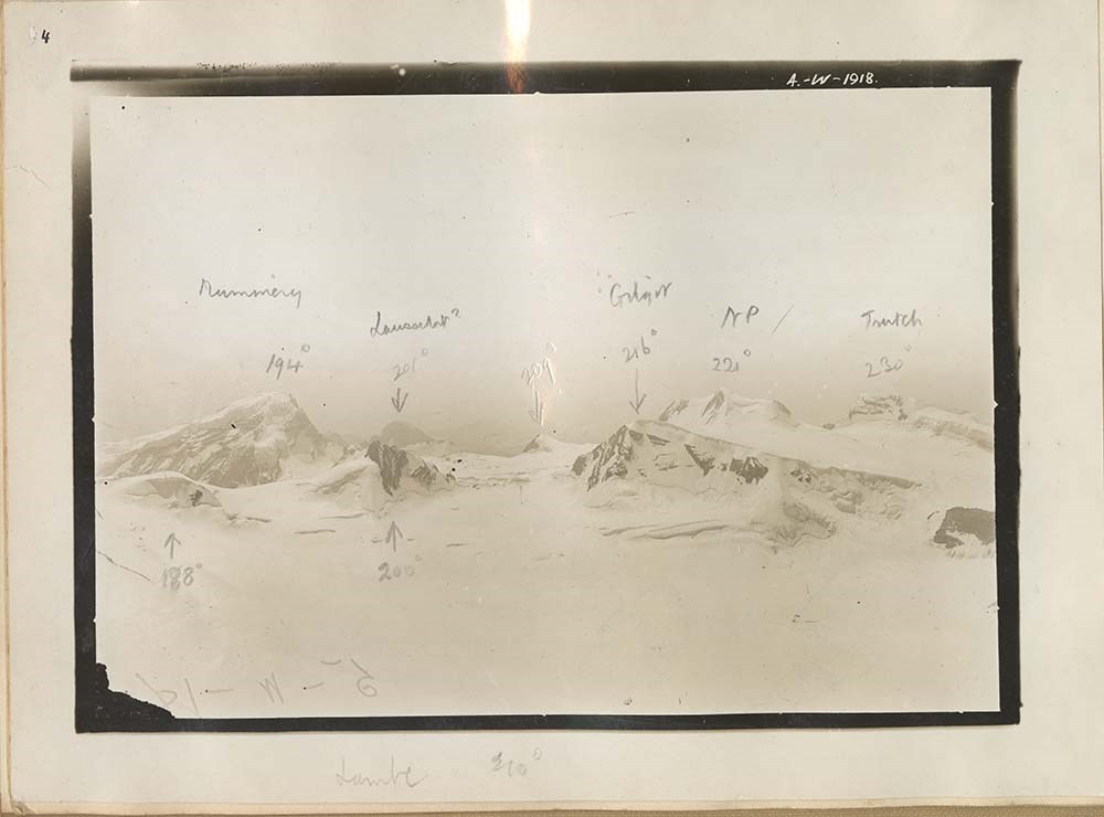
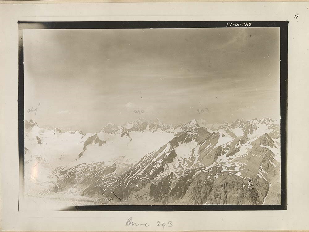
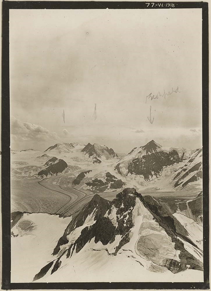
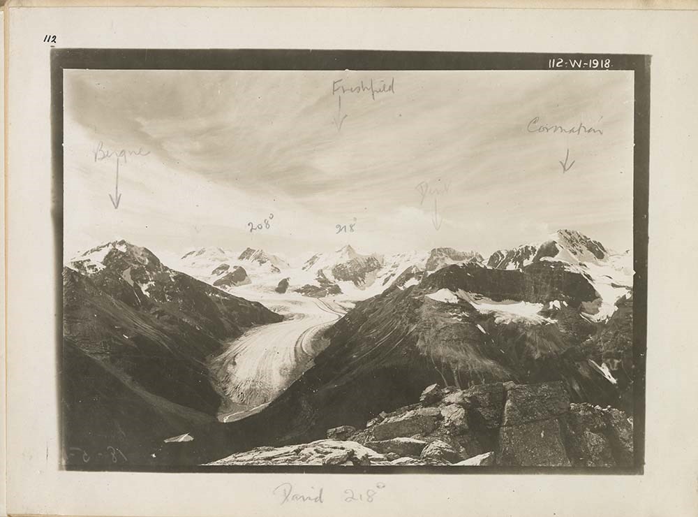
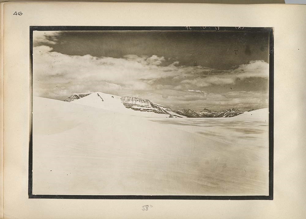
Alberta- British Columbia Boundary Commission. Photographs by A.O. Wheeler. B. C. L. S.1918. vol.1A, Stations 49 -56
https://archives.whyte.org/en/permalink/descriptions22812
- Part Of
- Arthur Oliver Wheeler fonds
- Scope & Content
- Alberta- British Columbia Boundary Commission. Photographs by A.O. Wheeler. Vol 1A. Stations 49 -56. Includes list of stations with bearings and coordinates for each related photograph. Annotations appear on some photographs and descriptions underneath photographs. Front cover has page taped to cov…
- Date Range
- 1918
- Reference Code
- V771 / PD -14
- Description Level
- 5 / File
4 images
- Part Of
- Arthur Oliver Wheeler fonds
- Description Level
- 5 / File
- Fonds Number
- V771
- Sous-Fonds
- V771
- Accession Number
- 8144
- Reference Code
- V771 / PD -14
- Date Range
- 1918
- Physical Description
- 1 photograph album: 27 pages
- Scope & Content
- Alberta- British Columbia Boundary Commission. Photographs by A.O. Wheeler. Vol 1A. Stations 49 -56. Includes list of stations with bearings and coordinates for each related photograph. Annotations appear on some photographs and descriptions underneath photographs. Front cover has page taped to cover, " Alan Campbell, Arras ant SE end, Freshfield from W, PKs S of Bluewater G.".
- Subject Access
- Surveying/ Cartography
- Mountains
- Title Source
- Title taken from source.
- Processing Status
- Processed
Images


This material is presented as originally created; it may contain outdated cultural descriptions and
potentially offensive content.
Read more.
Alberta- British Columbia Boundary Commission. Photographs by A.O. Wheeler. B. C. L. S.1918. vol.1B, Stations 56 -61
https://archives.whyte.org/en/permalink/descriptions22813
- Part Of
- Arthur Oliver Wheeler fonds
- Scope & Content
- Alberta- British Columbia Boundary Commission. Photographs by A.O. Wheeler. Vol 1B. Stations 56 -61. Includes list of stations with bearings and coordinates for each related photograph. Annotations appear on some descriptions underneath photographs. Clear plastic has been taped onto portions of som…
- Date Range
- 1918
- Reference Code
- V771 / PD -15
- Description Level
- 5 / File
3 images
- Part Of
- Arthur Oliver Wheeler fonds
- Description Level
- 5 / File
- Fonds Number
- V771
- Sous-Fonds
- V771
- Accession Number
- 8144
- Reference Code
- V771 / PD -15
- Date Range
- 1918
- Physical Description
- 1 photograph album: 27 pages
- Scope & Content
- Alberta- British Columbia Boundary Commission. Photographs by A.O. Wheeler. Vol 1B. Stations 56 -61. Includes list of stations with bearings and coordinates for each related photograph. Annotations appear on some descriptions underneath photographs. Clear plastic has been taped onto portions of some of the photographs. Front cover has page taped to cover, " Alan Campbell, Mons fault- S, Upper Bluewater w, [Arras Gaficline], Mummery N, Fairfield W.".
- Subject Access
- Surveying/ Cartography
- Mountains
- Title Source
- Title taken from source.
- Processing Status
- Processed
Images


This material is presented as originally created; it may contain outdated cultural descriptions and
potentially offensive content.
Read more.
Alberta- British Columbia Boundary Commission. Photographs by A.O. Wheeler. B. C. L. S.1918. vol.2A, Stations 61 -65
https://archives.whyte.org/en/permalink/descriptions22891
- Part Of
- Arthur Oliver Wheeler fonds
- Scope & Content
- Alberta- British Columbia Boundary Commission. Photographs by A.O. Wheeler. Vol 2A. Stations 61 -65.Stations 13-17 was originally typed, then crossed out and changed to 61-65 in handwriting. Includes list of stations with bearings and coordinates for each related photograph. Annotations appear on s…
- Date Range
- 1918
- Reference Code
- V771 / PD -16
- Description Level
- 5 / File
1 image
- Part Of
- Arthur Oliver Wheeler fonds
- Description Level
- 5 / File
- Fonds Number
- V771
- Sous-Fonds
- V771
- Accession Number
- 8144
- Reference Code
- V771 / PD -16
- Date Range
- 1918
- Physical Description
- 1 photograph album: 27 pages
- Scope & Content
- Alberta- British Columbia Boundary Commission. Photographs by A.O. Wheeler. Vol 2A. Stations 61 -65.Stations 13-17 was originally typed, then crossed out and changed to 61-65 in handwriting. Includes list of stations with bearings and coordinates for each related photograph. Annotations appear on some descriptions underneath photographs. Clear plastic has been taped onto portions of some of the photographs. Front cover has page taped to cover, "Cockscomb nat SE, Mons fault SE"
- Subject Access
- Surveying/ Cartography
- Mountains
- Title Source
- Title taken from source.
- Processing Status
- Processed
Images
This material is presented as originally created; it may contain outdated cultural descriptions and
potentially offensive content.
Read more.
Alberta- British Columbia Boundary Commission. Photographs by A.O. Wheeler. B. C. L. S.1918. vol.3A, Stations 72 -76
https://archives.whyte.org/en/permalink/descriptions22893
- Part Of
- Arthur Oliver Wheeler fonds
- Scope & Content
- Alberta- British Columbia Boundary Commission. Photographs by A.O. Wheeler. Vol 3A. Stations 72 -76.Stations 24-28 was originally typed, then crossed out and changed to 72-76 in handwriting. Includes list of stations with bearings and coordinates for each related photograph. Annotations appear on s…
- Date Range
- 1918
- Reference Code
- V771 / PD -18
- Description Level
- 5 / File
2 images
- Part Of
- Arthur Oliver Wheeler fonds
- Description Level
- 5 / File
- Fonds Number
- V771
- Sous-Fonds
- V771
- Accession Number
- 8144
- Reference Code
- V771 / PD -18
- Date Range
- 1918
- Physical Description
- 1 photograph album: 27 pages
- Scope & Content
- Alberta- British Columbia Boundary Commission. Photographs by A.O. Wheeler. Vol 3A. Stations 72 -76.Stations 24-28 was originally typed, then crossed out and changed to 72-76 in handwriting. Includes list of stations with bearings and coordinates for each related photograph. Annotations appear on some descriptions underneath photographs. Clear plastic has been taped onto portions of some of the photographs, this plastic has been written on in pen. Front cover has page taped to cover, "N end Mons fault, Mt. Bryce E, E of Re[?]i Br (syncline E of Cockscomb ont), W of Bush R."
- Subject Access
- Surveying/ Cartography
- Mountains
- Title Source
- Title taken from source.
- Processing Status
- Processed
Images


This material is presented as originally created; it may contain outdated cultural descriptions and
potentially offensive content.
Read more.
Dictionary of altitudes in the Dominion of Canada
https://archives.whyte.org/en/permalink/catalogue11982
- Medium
- Library - Book (including soft-cover and pamphlets)
- Published Date
- 1916
- Author
- White, James
- Publisher
- Ottawa : Commission of Conservation Canada
- Edition
- 2 ed
- Call Number
- 03.3 W58d
- 03.3 W58d c.2
- Author
- White, James
- Responsibility
- Commission of Conservation Canada
- Edition
- 2 ed
- Publisher
- Ottawa : Commission of Conservation Canada
- Published Date
- 1916
- Physical Description
- xii, 251 p. : ill
- Accession Number
- 400
- 2023.47
- Call Number
- 03.3 W58d
- 03.3 W58d c.2
- Collection
- Archives Library
This material is presented as originally created; it may contain outdated cultural descriptions and
potentially offensive content.
Read more.
Maps of Banff and Western Canada
https://archives.whyte.org/en/permalink/descriptions54772
- Part Of
- Luxton family fonds
- Scope & Content
- File consists of 9 printed maps, b&w and col. [including zoning and topographical maps] depicting the Town of Banff and Banff National Park, the Rocky Mountains Forest Reserve, the Moose Mountain region, Medicine Hat, and the province of Alberta. File includes Trail Riders' Map of the Canadian Rock…
- Date Range
- 1912
- 1914
- 1924
- 1926
- 1932
- 1957
- [1970-1980]
- Reference Code
- LUX / II / C5 / 25
- Description Level
- 5 / File
- GMD
- Textual record
- Published record
- Map
- Part Of
- Luxton family fonds
- Description Level
- 5 / File
- Fonds Number
- LUX
- Series
- LUX / II / C : Personal
- Sous-Fonds
- LUX / II : Eleanor Luxton sous-fonds
- Sub-Series
- LUX / II / C5 : Other
- Accession Number
- LUX
- Reference Code
- LUX / II / C5 / 25
- Date Range
- 1912
- 1914
- 1924
- 1926
- 1932
- 1957
- [1970-1980]
- Physical Description
- 9 maps : b&w and col. ; 168 x 71 cm or smaller
- Scope & Content
- File consists of 9 printed maps, b&w and col. [including zoning and topographical maps] depicting the Town of Banff and Banff National Park, the Rocky Mountains Forest Reserve, the Moose Mountain region, Medicine Hat, and the province of Alberta. File includes Trail Riders' Map of the Canadian Rockies which has smaller maps of Waterton Lakes, Glacier, Revelstoke, and other national parks printed on the back. Map of Medicine Hat includes annotated storage envelope with dimensions written on the front.
- Subject Access
- Cartography
- Geography
- Land use
- Government
- Travel
- National parks and reserves
- Geographic Access
- Canada
- Alberta
- Banff
- Banff National Park
- Medicine Hat
- Rocky Mountains
- Glacier National Park
- Revelstoke
- Waterton Lakes National Park
- Reproduction Restrictions
- Restrictions may apply
- Language
- English
- Title Source
- Title based on contents of file
- Processing Status
- Processed
This material is presented as originally created; it may contain outdated cultural descriptions and
potentially offensive content.
Read more.
- Date
- 1917 – 1929
- Medium
- graphite on paper
- Catalogue Number
- WyP.03.583
- Description
- A pencil drawing of the outline of the South American continent. Drawing occupies entire paper.
1 image
- Title
- Untitled
- Date
- 1917 – 1929
- Medium
- graphite on paper
- Dimensions
- 22.5 x 15.1 cm
- Description
- A pencil drawing of the outline of the South American continent. Drawing occupies entire paper.
- Subject
- South America
- map
- geography
- cartography
- Credit
- Gift of Catharine Robb Whyte, O. C., Banff, 1979
- Catalogue Number
- WyP.03.583
Images

This material is presented as originally created; it may contain outdated cultural descriptions and
potentially offensive content.
Read more.
- Date
- 1914 – 1925
- Medium
- graphite on paper
- Catalogue Number
- WyP.03.658
- Description
- Unfinished pencil drawing of what appears to be a jagged coastline. Drawing appears in tlc of paper. Straight lines run parallel to all edges and intersect at corners to form a frame.
1 image
- Title
- Untitled
- Date
- 1914 – 1925
- Medium
- graphite on paper
- Dimensions
- 22.5 x 15.0 cm
- Description
- Unfinished pencil drawing of what appears to be a jagged coastline. Drawing appears in tlc of paper. Straight lines run parallel to all edges and intersect at corners to form a frame.
- Subject
- map
- cartography
- Credit
- Gift of Catharine Robb Whyte, O. C., Banff, 1979
- Catalogue Number
- WyP.03.658
Images

This material is presented as originally created; it may contain outdated cultural descriptions and
potentially offensive content.
Read more.
Views of Interprovincial Boundary Survey. A.O. Wheeler. B. C. L. S.1919. vol.1, Stations 81-86 (6 volumes)
https://archives.whyte.org/en/permalink/descriptions22895
- Part Of
- Arthur Oliver Wheeler fonds
- Scope & Content
- Views of Interprovincial Boundary Survey. A.O.Wheeler Vol 1. Stations 81-86. Includes list of stations with bearings and coordinates for each related photograph. Annotations appear on some photographs. Clear plastic has been taped onto portions of some of the photographs, this plastic has been wri…
- Date Range
- 1919
- Reference Code
- V771 / PD -20
- Description Level
- 5 / File
3 images
- Part Of
- Arthur Oliver Wheeler fonds
- Description Level
- 5 / File
- Fonds Number
- V771
- Sous-Fonds
- V771
- Accession Number
- 8144
- Reference Code
- V771 / PD -20
- Date Range
- 1919
- Physical Description
- 1 photograph album: 27 pages
- Scope & Content
- Views of Interprovincial Boundary Survey. A.O.Wheeler Vol 1. Stations 81-86. Includes list of stations with bearings and coordinates for each related photograph. Annotations appear on some photographs. Clear plastic has been taped onto portions of some of the photographs, this plastic has been written on in pen in some instances. Front cover has page taped to cover, "Cockscomb ant. Kemmet, E [lijub] Cockscomb ant to Alexandra, Mons fault- Lyell [C-B], NE Bryce, NW Bush R"
- Subject Access
- Surveying/ Cartography
- Mountains
- Title Source
- Title taken from source.
- Processing Status
- Processed
Images


This material is presented as originally created; it may contain outdated cultural descriptions and
potentially offensive content.
Read more.