Narrow Results By
The last of his kind : the life and adventures of Bradford Washburn, America's boldest mountaineer
https://archives.whyte.org/en/permalink/catalogue13923
- Medium
- Library - Book (including soft-cover and pamphlets)
- Published Date
- 2009
- Author
- Roberts, David
- Publisher
- New York, N.Y. : William Morrow
- Edition
- 1st ed.
- Call Number
- 01 R54l
- Author
- Roberts, David
- Responsibility
- David Roberts
- Edition
- 1st ed.
- Publisher
- New York, N.Y. : William Morrow
- Published Date
- 2009
- Physical Description
- 334 p., [16] p of plates : ill.
- ISBN
- 0061560944
- Accession Number
- 60, 500 2011-01-13
- Call Number
- 01 R54l
- Collection
- Archives Library
This material is presented as originally created; it may contain outdated cultural descriptions and
potentially offensive content.
Read more.

Map Drawing Book For Use in Public Schools
https://archives.whyte.org/en/permalink/artifactwyp.03.584
- Date
- c. 1914
- Medium
- graphite on paper
- Catalogue Number
- WyP.03.584
- Description
- Peter Whyte’s Map Drawing sketchbook, likely an exercise book for school, with a printed cover page and map drawings inside. Cover page reads: MAP DRAWING BOOK [across top]; FOR USE IN THE PUBLIC SCHOOLS/ THE COPP, CLARK CO., LIMITED, TORONTO [across bottom] Inside, pencil drawings include: the Gul…
1 image
- Title
- Map Drawing Book For Use in Public Schools
- Date
- c. 1914
- Medium
- graphite on paper
- Dimensions
- 24.9 x 31.0 cm
- Description
- Peter Whyte’s Map Drawing sketchbook, likely an exercise book for school, with a printed cover page and map drawings inside. Cover page reads: MAP DRAWING BOOK [across top]; FOR USE IN THE PUBLIC SCHOOLS/ THE COPP, CLARK CO., LIMITED, TORONTO [across bottom] Inside, pencil drawings include: the Gulf of St. Lawrence, the Philippine Islands, Asia and the Middle East, and Africa.
- Subject
- world
- map
- globe
- geography
- cartography
- Asia
- Middle East
- Africa
- Philippine Islands
- Gulf of St. Lawrence
- Credit
- Gift of Catharine Robb Whyte, O. C., Banff, 1975
- Catalogue Number
- WyP.03.584
Images

This material is presented as originally created; it may contain outdated cultural descriptions and
potentially offensive content.
Read more.
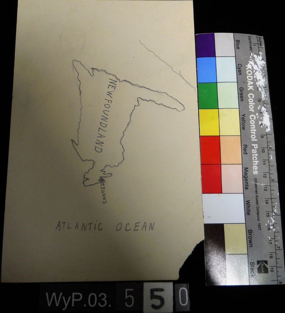
Map of Newfoundland
https://archives.whyte.org/en/permalink/artifactwyp.03.550
- Date
- n.d.
- Medium
- graphite on paper
- Catalogue Number
- WyP.03.550
- Description
- A pencil drawn map of Newfoundland, including the Atlantic Ocean.
1 image
- Title
- Map of Newfoundland
- Date
- n.d.
- Medium
- graphite on paper
- Dimensions
- 22.5 x 15.1 cm
- Description
- A pencil drawn map of Newfoundland, including the Atlantic Ocean.
- Subject
- map
- cartography
- Newfoundland
- Atlantic Ocean
- Credit
- Gift of Catharine Robb Whyte, O. C., Banff, 1979
- Catalogue Number
- WyP.03.550
Images
This material is presented as originally created; it may contain outdated cultural descriptions and
potentially offensive content.
Read more.
- Date
- n.d.
- Medium
- graphite; ink on paper
- Catalogue Number
- WyP.03.549
- Description
- An ink and pencil drawing of Quebec, New Brunswick, Ontario and Manitoba, from a cartographical perspective.
1 image
- Title
- Map of Quebec
- Date
- n.d.
- Medium
- graphite; ink on paper
- Dimensions
- 22.5 x 15.1 cm
- Description
- An ink and pencil drawing of Quebec, New Brunswick, Ontario and Manitoba, from a cartographical perspective.
- Subject
- map
- cartography
- Ontario
- Manitoba
- New Brunswick
- Quebec
- Credit
- Gift of Catharine Robb Whyte, O. C., Banff, 1979
- Catalogue Number
- WyP.03.549
Images

This material is presented as originally created; it may contain outdated cultural descriptions and
potentially offensive content.
Read more.
Mountains : mapping the earth's extremes
https://archives.whyte.org/en/permalink/catalogue19921
- Medium
- Library - Book (including soft-cover and pamphlets)
- Published Date
- 2016
- Author
- Dech, Stefan
- Messner, Reinhold
- Sparwasser, Nils
- Publisher
- London, England : Thames and Hudson
- Call Number
- GA D43 M68
1 website
- Responsibility
- Stefan Dech, Reinhold Messner, Nils Sparwasser
- Publisher
- London, England : Thames and Hudson
- Published Date
- 2016
- Physical Description
- 240 p. illus. (colour)
- Subjects
- Mountains
- Maps
- Cartography
- Photography, Aerial
- Abstract
- Mountains marks a new milestone in Earth observation and Alpine exploration. For the first time, a special recording process and a technique developed at the German Aerospace Center (DLR) allow the satellite recording of three-dimensional views from 300 miles above with a resolution in the range of a few meters. Photorealistic images are created in this manner from perspectives denied even to mountaineers and helicopter pilots. In addition to highly accurate detailed models of individual regions, the DLR generates a global three-dimensional elevation model of Earth in unprecedented quality. For this purpose, two German satellites are currently circling the earth at a speed of more than 15,000 miles per hour—separated by a mere 500 feet. Taken together, both techniques offer a detailed view of a world that still pushes human beings to their limits—the mountainous regions of our planet. For this book Reinhold Messner has selected thirteen peaks and routes to feature, as they’ve never been seen before. (from publisher's website)
- Contents
- Trailblazers
- Mountains: the fourth dimension
- Of scientists and mountaineers : the making of this book
- Kailash
- Mont Blanc
- Matterhorn
- Ushba
- Denali
- Aconcagua
- Nanda Devi
- Mount Everest
- K2
- Dhaulagiri
- Annapurna
- Masherbrum
- Histories
- Profiles
- From data to images
- Editors, authors and project partners
- Index
- ISBN
- 9780500518892
- Accession Number
- AC635
- Call Number
- GA D43 M68
- Collection
- Alpine Club of Canada Library
- URL Notes
- Publisher's website
Websites
This material is presented as originally created; it may contain outdated cultural descriptions and
potentially offensive content.
Read more.
- Date
- n.d.
- Medium
- graphite; ink on paper
- Catalogue Number
- WyP.03.552
- Description
- A pencil and ink drawing of a map of South America. Rio de Janeiro is labeled on right edge of the continent.
1 image
- Title
- Untitled
- Date
- n.d.
- Medium
- graphite; ink on paper
- Dimensions
- 22.5 x 15.1 cm
- Description
- A pencil and ink drawing of a map of South America. Rio de Janeiro is labeled on right edge of the continent.
- Subject
- South America
- Rio de Janeiro
- map
- cartography
- Credit
- Gift of Catharine Robb Whyte, O. C., Banff, 1979
- Catalogue Number
- WyP.03.552
Images
This material is presented as originally created; it may contain outdated cultural descriptions and
potentially offensive content.
Read more.
- Date
- 1917 – 1929
- Medium
- graphite on paper
- Catalogue Number
- WyP.03.583
- Description
- A pencil drawing of the outline of the South American continent. Drawing occupies entire paper.
1 image
- Title
- Untitled
- Date
- 1917 – 1929
- Medium
- graphite on paper
- Dimensions
- 22.5 x 15.1 cm
- Description
- A pencil drawing of the outline of the South American continent. Drawing occupies entire paper.
- Subject
- South America
- map
- geography
- cartography
- Credit
- Gift of Catharine Robb Whyte, O. C., Banff, 1979
- Catalogue Number
- WyP.03.583
Images

This material is presented as originally created; it may contain outdated cultural descriptions and
potentially offensive content.
Read more.
- Date
- 1914 – 1925
- Medium
- graphite on paper
- Catalogue Number
- WyP.03.658
- Description
- Unfinished pencil drawing of what appears to be a jagged coastline. Drawing appears in tlc of paper. Straight lines run parallel to all edges and intersect at corners to form a frame.
1 image
- Title
- Untitled
- Date
- 1914 – 1925
- Medium
- graphite on paper
- Dimensions
- 22.5 x 15.0 cm
- Description
- Unfinished pencil drawing of what appears to be a jagged coastline. Drawing appears in tlc of paper. Straight lines run parallel to all edges and intersect at corners to form a frame.
- Subject
- map
- cartography
- Credit
- Gift of Catharine Robb Whyte, O. C., Banff, 1979
- Catalogue Number
- WyP.03.658
Images

This material is presented as originally created; it may contain outdated cultural descriptions and
potentially offensive content.
Read more.