Narrow Results By
- Alpine Club of Canada 19
- Douglas Leighton 4
- Leighton, Douglas 4
- Alexander, Richard Henry 1
- Kay, Dave and D.A. MacDonald 1
- Lindsay, F.W. 1
- Metcalf, Vicky 1
- Milton, Viscount William Fitzwilliam 1
- Neave, Roland, ed 1
- Shewchuk, Murphy 1
- Smedley-L'Heureux, Audrey 1
- Western Canada Conservation Representative 1
[Anahim Lake, B.C.] Canada Land Inventory Map, Land capability for wildlife-ungulates
https://archives.whyte.org/en/permalink/catalogue24004
- Medium
- Library - Maps and blueprints (unannotated; published)
- Map
- Published Date
- 1971
- Publisher
- Dept. of Energy, Mines and Resources
- Call Number
- NTS
- 93C
- Publisher
- Dept. of Energy, Mines and Resources
- Published Date
- 1971
- Physical Description
- 1 map : col
- Scale
- Scale: 1:250,000
- Subjects
- Anahim Lake
- British Columbia
- Accession Number
- 4000
- Call Number
- NTS
- 93C
- Collection
- Archives Library
This material is presented as originally created; it may contain outdated cultural descriptions and
potentially offensive content.
Read more.
[Angus Horne Lake 83D/5 B.C.]
https://archives.whyte.org/en/permalink/catalogue23450
- Medium
- Library - Maps and blueprints (unannotated; published)
- Map
- Published Date
- 1972
- Publisher
- Department of Energy, Mines and Resources
- Call Number
- NTS
- 83D/5
- Publisher
- Department of Energy, Mines and Resources
- Published Date
- 1972
- Physical Description
- 1 map : col
- Scale
- Scale: 1:50,000
- Relief: Contour interval 100 ft.
- Subjects
- Angus Horne Lake
- British Columbia
- Notes
- National Topographic System
- Accession Number
- 7000
- Call Number
- NTS
- 83D/5
- Collection
- Archives Library
This material is presented as originally created; it may contain outdated cultural descriptions and
potentially offensive content.
Read more.
[Azure River 83D/12 B.C.]
https://archives.whyte.org/en/permalink/catalogue23458
- Medium
- Library - Maps and blueprints (unannotated; published)
- Map
- Published Date
- 1972
- Publisher
- Department of Energy, Mines and Resources
- Call Number
- NTS
- 83D/12
- Publisher
- Department of Energy, Mines and Resources
- Published Date
- 1972
- Physical Description
- 1 map : col
- Scale
- Scale: 1:50,000
- Relief: Contour interval 100 ft.
- Subjects
- Azure River
- British Columbia
- Notes
- National Topographic System
- Accession Number
- 7000
- 7030
- Call Number
- NTS
- 83D/12
- Collection
- Archives Library
This material is presented as originally created; it may contain outdated cultural descriptions and
potentially offensive content.
Read more.
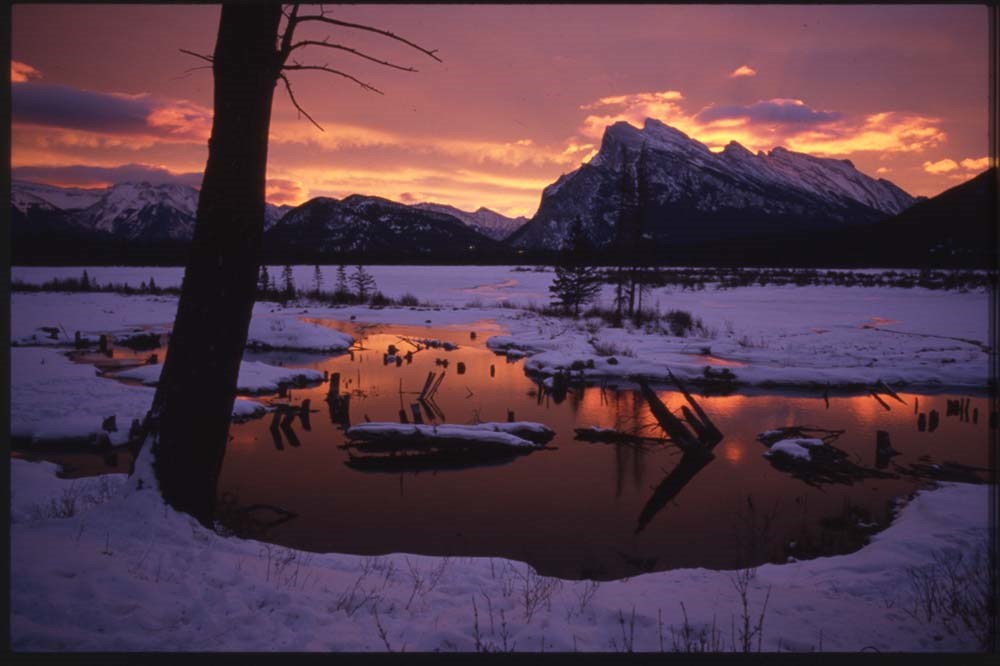
Banff "active best"
https://archives.whyte.org/en/permalink/descriptions56444
- Part Of
- Douglas Leighton fonds
- Scope & Content
- File consists of photographs compiled by Douglas Leighton for publication. Includes photographs of landscapes, lakes, mountains, hotel, tourists, waterfalls and glaciers.
- Date Range
- 1978
- 1979
- 1984
- 1986 - 1993
- 1995
- 1996
- Reference Code
- V222 / VI / C / 2 / NS - 1 to 155
- Description Level
- 5 / File
- GMD
- Photograph
- Transparency
- Part Of
- Douglas Leighton fonds
- Description Level
- 5 / File
- Fonds Number
- M133
- V222
- Series
- V222 / VI : Publication
- Sous-Fonds
- V222
- Sub-Series
- V222 / VI / C: Compiled for publication
- Accession Number
- 2020.24
- Reference Code
- V222 / VI / C / 2 / NS - 1 to 155
- Date Range
- 1978
- 1979
- 1984
- 1986 - 1993
- 1995
- 1996
- Physical Description
- 155 photographs : col. slides ; 35 mm
- Scope & Content
- File consists of photographs compiled by Douglas Leighton for publication. Includes photographs of landscapes, lakes, mountains, hotel, tourists, waterfalls and glaciers.
- Name Access
- Leighton, Douglas
- Subject Access
- British Columbia
- Geographic Access
- Alberta
- Lake Louise, AB
- Banff National Park
- Banff
- Exshaw
- Canmore
- Language
- English
- Creator
- Douglas Leighton
- Title Source
- Title based on contents of file
- Processing Status
- Processed
This material is presented as originally created; it may contain outdated cultural descriptions and
potentially offensive content.
Read more.
B.C. Highway map
https://archives.whyte.org/en/permalink/catalogue24515
- Medium
- Library - Maps and blueprints (unannotated; published)
- Map
- Published Date
- 1975-76
- Publisher
- Lawson Graphics (Pacific)
- Call Number
- C10-1.4
- Publisher
- Lawson Graphics (Pacific)
- Published Date
- 1975-76
- Scale
- Scale: 1 inch - 34 miles
- Subjects
- British Columbia
- Highways
- Call Number
- C10-1.4
- Collection
- Archives Library
This material is presented as originally created; it may contain outdated cultural descriptions and
potentially offensive content.
Read more.
[Bennington Summit Register]
https://archives.whyte.org/en/permalink/descriptions57730
- Part Of
- Alpine Club of Canada fonds
- Scope & Content
- File consists of a summit record from Bennington Peak produced by the Alpine Club of Canada from around 1970. Entries are illegible due to severe water and mold damage. File: [Bennington Summit Register]
- Date Range
- ca. 1970
- Reference Code
- M200 / V / A / 138
- Description Level
- 5 / File
- GMD
- Textual record
- Organization record
- Part Of
- Alpine Club of Canada fonds
- Description Level
- 5 / File
- Fonds Number
- M200
- V14
- S6
- Series
- M200 / V: Summit Records
- Sous-Fonds
- M200
- Sub-Series
- M200 / V / A: Identified Summit Records
- Accession Number
- accn. 2023.18
- Reference Code
- M200 / V / A / 138
- Responsibility
- Summit Registers and Notes produced by Alpine Club of Canada
- Date Range
- ca. 1970
- Physical Description
- 1 volume 1 cm of textual record
- History / Biographical
- Bennington Peak is located along the Continental Divide/Great Divide along the Alberta/British Columbia provincial border. Bennington Peak is one of the peaks of Mount Fraser and is part of the Bennington Glacier. It is situated on on the border of Jasper National Park, Alberta and Mount Robson Provincial Park, British Columbia.
- Scope & Content
- File consists of a summit record from Bennington Peak produced by the Alpine Club of Canada from around 1970. Entries are illegible due to severe water and mold damage. File: [Bennington Summit Register]
- Notes
- Summit entries are illegible due to severe water and mold damage.
- Name Access
- Alpine Club of Canada
- Subject Access
- Alpine Club of Canada
- British Columbia
- Alberta
- Description and travel
- Mountain
- Mountains
- National parks and reserves
- Provincial parks and reserves
- Record keeping
- Summit
- Geographic Access
- Canada
- Continental Divide
- Great Divide
- Canadian Rocky Mountains
- Alberta
- British Columbia
- Jasper National Park
- Mount Robson Provincial Park
- Mount Fraser
- Bennington Peak
- Access Restrictions
- Restrictions may apply
- Conservation
- Register placed in mylar due to severe mold, water and rust damage. Entries in register are illegible due to damage.
- Related Material
- M235
- Biographical Source Notes
- Peak Finder: Bennington Peak, Canadian Rockies Database: https://cdnrockiesdatabases.ca/peaks/111
- Title Source
- Title based on contents of file
- Processing Status
- Processed
This material is presented as originally created; it may contain outdated cultural descriptions and
potentially offensive content.
Read more.
[British Columbia Highway] Highway map
https://archives.whyte.org/en/permalink/catalogue24514
- Medium
- Library - Maps and blueprints (unannotated; published)
- Map
- Published Date
- 1975-76
- Publisher
- Grant-Mann Lithographers Ltd.
- Call Number
- C10-1.3
- Publisher
- Grant-Mann Lithographers Ltd.
- Published Date
- 1975-76
- Scale
- Scale: 1 inch - 34 miles
- Subjects
- British Columbia
- Highways
- Call Number
- C10-1.3
- Collection
- Archives Library
This material is presented as originally created; it may contain outdated cultural descriptions and
potentially offensive content.
Read more.
[Bute Inlet, B.C.] Canada Land Inventory Map, Land capability for wildlife-ungulates
https://archives.whyte.org/en/permalink/catalogue24016
- Medium
- Library - Maps and blueprints (unannotated; published)
- Map
- Published Date
- 1971
- Publisher
- Dept. of Energy, Mines and Resouces
- Call Number
- NTS
- 92K
- Publisher
- Dept. of Energy, Mines and Resouces
- Published Date
- 1971
- Physical Description
- 1 map : col
- Scale
- Scale: 1:250,000
- Subjects
- Bute Inlet
- British Columbia
- Accession Number
- 4000
- Call Number
- NTS
- 92K
- Collection
- Archives Library
This material is presented as originally created; it may contain outdated cultural descriptions and
potentially offensive content.
Read more.
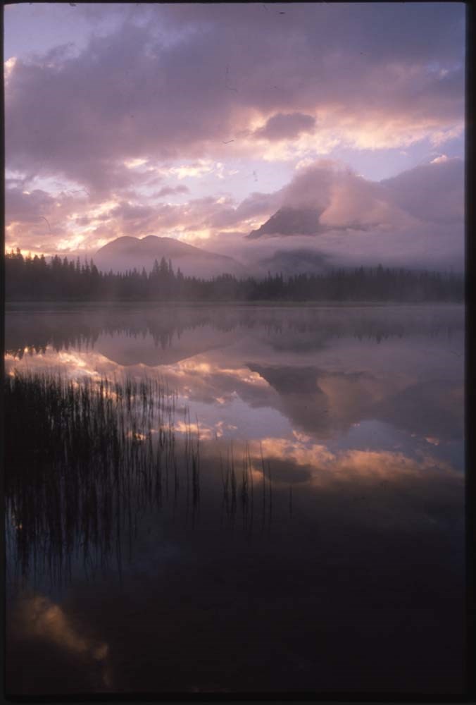
Canadian Rockies and other "active best"
https://archives.whyte.org/en/permalink/descriptions56446
- Part Of
- Douglas Leighton fonds
- Scope & Content
- File consists of photographs compiled by Douglas Leighton for publication. Includes photographs of landscapes, cityscapes, lakes, mountains, hotel, tourists, plants, waterfalls and glaciers.
- Date Range
- 1978
- 1981 - 1983
- 1987
- 1988
- 1990
- 1993 - 1995
- 1997
- 1998
- 2003
- 2006
- 2007
- Reference Code
- V222 / VI / C / 4 / NS - 1 to 119
- Description Level
- 5 / File
- GMD
- Photograph
- Transparency
4 images
- Part Of
- Douglas Leighton fonds
- Description Level
- 5 / File
- Fonds Number
- M133
- V222
- Series
- V222 / VI : Publication
- Sous-Fonds
- V222
- Sub-Series
- V222 / VI / C: Compiled for publication
- Accession Number
- 2020.24
- Reference Code
- V222 / VI / C / 4 / NS - 1 to 119
- Date Range
- 1978
- 1981 - 1983
- 1987
- 1988
- 1990
- 1993 - 1995
- 1997
- 1998
- 2003
- 2006
- 2007
- Physical Description
- 119 photographs : col. slides ; 35 mm
- Scope & Content
- File consists of photographs compiled by Douglas Leighton for publication. Includes photographs of landscapes, cityscapes, lakes, mountains, hotel, tourists, plants, waterfalls and glaciers.
- Name Access
- Leighton, Douglas
- Subject Access
- British Columbia
- Geographic Access
- Alberta
- British Columbia
- Banff National Park
- Banff
- Calgary, AB
- Edmonton, AB
- Kootenay, BC
- Yoho National Park
- Jasper National Park
- Cranbrook, BC
- Vancouver, BC
- Language
- English
- Creator
- Douglas Leighton
- Title Source
- Title based on contents of file
- Processing Status
- Processed
Images
This material is presented as originally created; it may contain outdated cultural descriptions and
potentially offensive content.
Read more.
Canadian Rockies Climbing Report
https://archives.whyte.org/en/permalink/catalogue15166
- Medium
- Library - Book (including soft-cover and pamphlets)
- Published Date
- June 21 1972
- Call Number
- F1090 J37
- Responsibility
- Japanese University student climbing group
- Published Date
- June 21 1972
- Physical Description
- 51 pages, ill.
- Notes
- Report of Japanese University students of their trip to Western Canada (Alberta, BC) and their climbing expepditions in the Rocky Mountains. Includes articles written by students about their experiences, a full itinerary of their trip, diagrams of Columbia Icefield traverse, photos and cost of trip.
- Article about Banff
- Call Number
- F1090 J37
- Collection
- Alpine Club of Canada Library
This material is presented as originally created; it may contain outdated cultural descriptions and
potentially offensive content.
Read more.