Narrow Results By
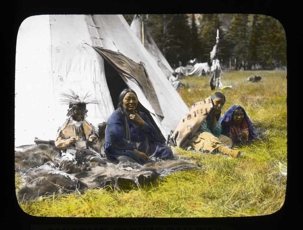
Banff - An Indigenous Family
https://archives.whyte.org/en/permalink/descriptions39498
- Part Of
- Moore family fonds
- Scope & Content
- Unidentified family
- Date Range
- 1927
- Reference Code
- V439 / PS - 324
- Description Level
- 6 / Item
- GMD
- Photograph
- Lantern slide
- Transparency
1 image
- Part Of
- Moore family fonds
- Description Level
- 6 / Item
- Fonds Number
- M307 / V439
- Series
- I. Philip Moore series
- Sous-Fonds
- V439
- Sub-Series
- B. Professional papers and photographs 2. Research, writing and lecturing d. Photographs i. Lantern slides (transparencies)
- Reference Code
- V439 / PS - 324
- Date Range
- 1927
- Physical Description
- 1 transparency : lantern slide
- Scope & Content
- Unidentified family
- Subject Access
- Buildings and memorials
- Discovery and Exploration
- Family and personal life
- First nations
- Geographic Access
- Alberta
- Creator
- Brigden's
- Processing Status
- Processed
Images
This material is presented as originally created; it may contain outdated cultural descriptions and
potentially offensive content.
Read more.
Cartographic Materials
https://archives.whyte.org/en/permalink/descriptions23065
- Part Of
- Hans Gmoser fonds
- Scope & Content
- Cartographic materials in these four oversized files consist of the following:
- Date Range
- 1914-1973
- Reference Code
- M224 / O.S. Cartographic
- Description Level
- 5 / File
- Part Of
- Hans Gmoser fonds
- Description Level
- 5 / File
- Series
- IV.C. Textual records: Cartographic records
- Accession Number
- 7361, 7877, 8111
- Reference Code
- M224 / O.S. Cartographic
- Date Range
- 1914-1973
- Physical Description
- 48 cartographic records.
- Scope & Content
- Cartographic materials in these four oversized files consist of the following:
- Subject Access
- Discovery and Exploration
- Environment and Nature
- Family and personal life
- Sports and Recreation
- Title Source
- Title based on contents.
- Content Details
- Folder 1 Map on heavy paper, wrapped in plastic. “A Reconnaissance Topographic Map Suveyed and edited by Bradford Washburn” printed in Bern, Switzerland. Centred on Mt. McKinley.- From 7361. Palliser- Kananaskis Area British Columbia and Alberta- Publication No. 1962- Reprinted by the Surveys and Mapping Branch, Department of Mines and Technical Surveys, Ottawa. Mistaya British Columbia and Alberta- Compiled, drawn and printed at the office of the Surveyor General, Ottawa, 1931. Reprinted with corrections at the Surveys and Mapping Branch, Ottawa, 1950. National Topographic Series. Yoho British Columbia and Alberta- Compiled, drawn and printed at the office of the Surveyor General, Ottawa, 1932. Reprinted with corrections at the Surveys and Mapping Branch, Ottawa, 1952. National Topographic Series. Price 25 cents. Invermere British Columbia Kootenay Land District- National Topographic System- First Status Edition compiled and produced by the Geographic Division, Surveys, and Mapping Branch, Dept. of Lands, Forests and Water Resources, Victoria, BC 1964-65- annotated Beaton British Columbia Kootenay Land District- National Topographic System- First Status Edition compiled and produced by the Geographic Division, Surveys, and Mapping Branch, Dept. of Lands, Forests and Water Resources, Victoria, BC 1964-66- annotated Lardeau British Columbia Kootenay Land District- National Topographic System- First Status Edition compiled and produced by the Geographic Division, Surveys, and Mapping Branch, Dept. of Lands, Forests and Water Resources, Victoria, BC 1963- annotated Mount McKinley Alaska, Published by the Museum of Science, Boston, Mass, USA and the Swiss Foundation for Alpine Research, Zurich. 1960. Centennial Range Yukon Territory- M.C.R. 7 Edition 1- Produced and printed 1967 by the Surveys and Mapping Branch, Department of Energy, Mines and Resources- maps printed in 1961-62- annotated British Columbia Land Recording Dists.- Land Commissioner’s Offices- Department of Lands and Forests- first published 1957- Updated Nov. 1, 1960. Master Site Plan Bugaboo Creek Lodge Project number 6844- June 18, 1973- Cohos Delesalle & Evamy. Folder 2 Boundary Between Alberta and BC- Athabasca Pass- Sheet No. 27A – annotated- centered on Jasper Park Boundary Between Alberta and BC-All below Wheeler Maps (by hand) used for the Great Divide as per Chic-no topographical maps used for both Hans and similar maps were used by Chic bottom rip taped- Sheet No. 20- Drawn and printed by the Topographical Survey of Canada, Ottawa - centered on Clearwater forest and Lyell Icefield at bottom right Boundary Between Alberta and BC- Sheet No. 15- Drawn and printed at the Surveyor General’s Office, Ottawa, Canada- centered on Rocky Mountains Park Boundary Between Alberta and BC - Sheet No. 19- Drawn and printed at the Surveyor General’s Office, Ottawa, Canada- centered on centered on Clearwater Forest with Mt. Alan Campbell at bottom Boundary Between Alberta and BC- Sheet No. 25- annotated- Drawn and printed by the Topographical Survey of Canada, Ottawa - centered on Jasper Park with Chisel Peak at bottom Boundary Between Alberta and BC- Sheet No. 19- dirt and annotated- revised 1925- drawn and printed by the Topographical Survey of Canada, Ottawa- centered on Clearwater and Push Pass W. Boundary Between Alberta and BC- annotated- Sheet 16- revised 1925- drawn and printed by the Topographical Survey of Canada, Ottawa- centered on Yoho Park and Rocky Mountains Park Steele Glacier- Topographical Survey 1967 Arial Photography 1951 Mount St. Elias Canada- United State of America- Produced and Printed by the Surveys and Mapping Branch, Department of Mines and Technical Surveys 1962 from air photographs taken in 1951 and 1956- annotated Woolsey Glacier- Revelstoke National Park British Columbia – Printed by the Surveys and Mapping Branch Department of Energy, Mines and Resources- 1967 Windermere Kootenay District- Map 165A Issued 1918- Reprinted by the Surveys and Mapping Branch, Department of Mines and Technical Surveys, Ottawa. Folder 3 Boundary Between Alberta and BC- Sheet No. 20- heavily annotated- revised 1925- drawn and printed by the Topographical Survey of Canada, Ottawa- centered on Clearwater Forest, Saskatchewan Glacier at top left Boundary Between Alberta and BC- Sheet No. 18- heavily ripped- annotated - notes on back- revised 1925- drawn and printed by the Topographical Survey of Canada, Ottawa- centered on Clearwater Forest, Mt Mummery at bottom Boundary Between Alberta and BC- Sheet No. 17 (in pencil “A and B”)- annotated - heavily ripped- drawn and printed at the Surveyor Generals’ Office- centered on Clearwater Forest and Yoho Park Boundary Between Alberta and BC- Sheet No. 26- annotated- revised 1925- drawn and printed by the Topographical Survey of Canada, Ottawa- centered on Jasper Park and Icefields Boundary Between Alberta and BC- Sheet No. 17- revised 1925- drawn and printed by the Topographical Survey of Canada, Ottawa- centered on Clearwater Forest and Yoho Park Boundary Between Alberta and BC- Sheet No. 28- stained- centered on Jasper Park Boundary Between Alberta and BC- Sheet No. 24- annotated- revised edition, 1925- drawn and printed by the Topographical Survey of Canada, Ottawa- centered on Jasper Park Boundary Between Alberta and BC- Sheet No. 16- annotated- revised 1925- drawn and printed by the Topographical Survey of Canada, Ottawa- centered on Yoho and Rocky Mountains Park Interprovincial Boundary Commission Boundary Between Alberta and British Columbia. Revised edition 1925 drawn and printed by the Topographical Survey of Canada, Ottawa. Sheet No. 27. Following maps are from accession 7877. Interprovincial Boundary Commission Boundary Between Alberta and British Columbia. Surveyed 1920. Drawn and printed by the Topographical Survey of Canada, Ottawa. Sheet No. 26. Interprovincial Boundary Commission Boundary Between Alberta and British Columbia. Surveyed 1920, 1921. Drawn and printed by the Topographical Survey of Canada, Ottawa. Sheet No. 25. Interprovincial Boundary Commission Boundary Between Alberta and British Columbia. Surveyed 1919, 1921. Drawn and printed by the Topographical Survey of Canada, Ottawa. Sheet No. 24. Interprovincial Boundary Commission Boundary Between Alberta and British Columbia. Revised edition 1925 drawn and printed by the Topographical Survey of Canada, Ottawa. Sheet No. 21. Interprovincial Boundary Commission Boundary Between Alberta and British Columbia. Revised edition 1925 drawn and printed by the Topographical Survey of Canada, Ottawa. Sheet No. 18. Interprovincial Boundary Commission Boundary Between Alberta and British Columbia. Surveyed 1913. Drawn and printed by the Topographical Survey of Canada, Ottawa. Sheet No. 13 A. Interprovincial Boundary Commission Boundary Between Alberta and British Columbia. Surveyed 1916. Drawn and printed by the Topographical Survey of Canada, Ottawa. Sheet No. 12 A. Interprovincial Boundary Commission Boundary Between Alberta and British Columbia. Surveyed 1916. Drawn and printed by the Topographical Survey of Canada, Ottawa. Sheet No. 11. Interprovincial Boundary Commission Boundary Between Alberta and British Columbia. Surveyed 1916. Drawn and printed by the Topographical Survey of Canada, Ottawa. Sheet No. 10. Interprovincial Boundary Commission Boundary Between Alberta and British Columbia. Surveyed 1916. Drawn and printed by the Topographical Survey of Canada, Ottawa. Sheet No. 9. Interprovincial Boundary Commission Boundary Between Alberta and British Columbia. Surveyed 1916. Drawn and printed by the Topographical Survey of Canada, Ottawa. Sheet No. 8. Interprovincial Boundary Commission Boundary Between Alberta and British Columbia. Surveyed 1916. Drawn and printed by the Topographical Survey of Canada, Ottawa. Sheet No. 6. Interprovincial Boundary Commission Boundary Between Alberta and British Columbia. Surveyed 1915. Drawn and printed by the Topographical Survey of Canada, Ottawa. Sheet No. 5. Interprovincial Boundary Commission Boundary Between Alberta and British Columbia. Surveyed 1914. Drawn and printed by the Topographical Survey of Canada, Ottawa. Sheet No. 4. Interprovincial Boundary Commission Boundary Between Alberta and British Columbia. Surveyed 1922. Drawn and printed by the Topographical Survey of Canada, Ottawa. Sheet No. 31. Interprovincial Boundary Commission Boundary Between Alberta and British Columbia. Surveyed 1922, 1924. Drawn and printed by the Topographical Survey of Canada, Ottawa. Sheet No. 30. Interprovincial Boundary Commission Boundary Between Alberta and British Columbia. Surveyed 1917. Drawn and printed by the Topographical Survey of Canada, Ottawa. Sheet No. 29.
- Processing Status
- Processed
This material is presented as originally created; it may contain outdated cultural descriptions and
potentially offensive content.
Read more.
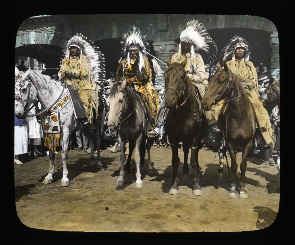
Courtyard of Banff Springs Hotel; Hector Crawler (Wachegiye) (Prayer Giver), Peter Wesley (Ta Otha) (Moose Hunter), unknown, unknown
https://archives.whyte.org/en/permalink/descriptions39510
- Part Of
- Moore family fonds
- Scope & Content
- Item consists of group in regalia on horseback in the courtyard of th Banff Springs Hotel, on left is Hector Crawler (Wachegiye) (Prayer Giver) and Peter Wesley (Ta Otha) (Moose Hunter) next to him.
- Date Range
- 1899 - 1927
- Reference Code
- V439 / PS - 336
- Description Level
- 6 / Item
- GMD
- Photograph
- Lantern slide
- Transparency
1 image
- Part Of
- Moore family fonds
- Description Level
- 6 / Item
- Fonds Number
- V439
- Series
- I. Philip Moore series
- Sous-Fonds
- V439
- Sub-Series
- B. Professional papers and photographs 2. Research, writing and lecturing d. Photographs i. Lantern slides (transparencies)
- Reference Code
- V439 / PS - 336
- Date Range
- 1899 - 1927
- Physical Description
- 1 transparency : lantern slide
- Scope & Content
- Item consists of group in regalia on horseback in the courtyard of th Banff Springs Hotel, on left is Hector Crawler (Wachegiye) (Prayer Giver) and Peter Wesley (Ta Otha) (Moose Hunter) next to him.
- Subject Access
- Stoney Nakoda
- Indigenous Peoples
- Buildings and memorials
- Discovery and exploration
- Environment and Nature
- First Nations
- Transportation
- Geographic Access
- Alberta
- Title Source
- Title is based on contents of item
- Processing Status
- Processed
Images
This material is presented as originally created; it may contain outdated cultural descriptions and
potentially offensive content.
Read more.
[Emmeline Savatard and Nello "Tex" Vernon-Wood packing horse, upper Red Deer Valley?, Banff Park]
https://archives.whyte.org/en/permalink/descriptions49439
- Part Of
- Archives General File Collection
- Scope & Content
- Image of a woman identified as Emmeline Savatard tightening the ropes on the load of a pack horse as a man identified as Nello "Tex" Vernon Wood assists.
- Date Range
- ca. 1915
- Reference Code
- v8 / 1 / 16 / na66 - 1912
- Description Level
- 6 / Item
- GMD
- Photograph
- Negative, copy
1 image
- Part Of
- Archives General File Collection
- Description Level
- 6 / Item
- Fonds Number
- V8
- Sous-Fonds
- V8
- Accession Number
- 2190
- Reference Code
- v8 / 1 / 16 / na66 - 1912
- Date Range
- ca. 1915
- Physical Description
- 1 photograph : negative : copy negative
- Scope & Content
- Image of a woman identified as Emmeline Savatard tightening the ropes on the load of a pack horse as a man identified as Nello "Tex" Vernon Wood assists.
- Notes
- From album of unidentified pack trip to Red Deer Valley, Big Horn Creek, Molar, Ptarmigan and Deception Pass with guides "Tex" Vernon Wood and Bert "Red" Johnson and possibily A.O. Wheeler and Emmaline Savatard
- Name Access
- Emmaline Savatard
- "Tex" Vernon Wood
- Subject Access
- Sports and Recreation
- Discovery and Exploration
- Women
- Geographic Access
- Alberta
- British Columbia
- Language
- English
- Location (Original)
- V8/accn 2190/pd-1
- Title Source
- From identification notes included in original photograph album
- Processing Status
- Processed
Images

This material is presented as originally created; it may contain outdated cultural descriptions and
potentially offensive content.
Read more.
Group of Indigenous children on Churchill River
https://archives.whyte.org/en/permalink/descriptions39464
- Part Of
- Moore family fonds
- Scope & Content
- Pertains to a group of Indigenous children posed in front of a building on Churchill River, Manitoba
- Date Range
- 1899 - 1927
- Reference Code
- V439 / PS - 290
- Description Level
- 6 / Item
- GMD
- Photograph
- Lantern slide
- Transparency
1 image
- Part Of
- Moore family fonds
- Description Level
- 6 / Item
- Fonds Number
- V439
- Series
- I. Philip Moore series
- Sous-Fonds
- V439
- Sub-Series
- B. Professional papers and photographs 2. Research, writing and lecturing d. Photographs i. Lantern slides (transparencies)
- Reference Code
- V439 / PS - 290
- Parallel Title
- Indians on Churchill River. [Manitoba]
- Date Range
- 1899 - 1927
- Physical Description
- 1 transparency : lantern slide
- Scope & Content
- Pertains to a group of Indigenous children posed in front of a building on Churchill River, Manitoba
- Geographic Access
- Manitoba
- Processing Status
- Processed
Images

This material is presented as originally created; it may contain outdated cultural descriptions and
potentially offensive content.
Read more.
Ice Bridge at Glacier
https://archives.whyte.org/en/permalink/descriptions39583
- Part Of
- Mary Schaffer fonds
- Scope & Content
- Charles R. Pancoast, Philadelphia
- Date Range
- [ca. 1900 - ca. 1920]
- Reference Code
- V527 / PS 4 - 2
- Description Level
- 6 / Item
- GMD
- Photograph
- Lantern slide
- Transparency
1 image
- Part Of
- Mary Schaffer fonds
- Description Level
- 6 / Item
- Series
- II. Photography series
- Sub-Series
- A. Lantern slides 11. General
- Reference Code
- V527 / PS 4 - 2
- Date Range
- [ca. 1900 - ca. 1920]
- Physical Description
- 1 transparency : lantern slide
- Scope & Content
- Charles R. Pancoast, Philadelphia
- Subject Access
- Discovery and Exploration
- Environment and Nature
- Sports and Recreation
- Geographic Access
- British Columbia
Images

This material is presented as originally created; it may contain outdated cultural descriptions and
potentially offensive content.
Read more.
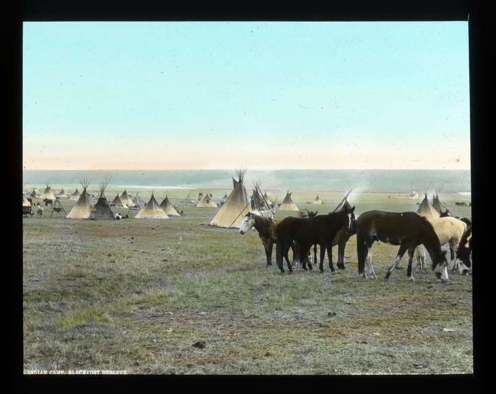
Indian Camp, Blackfoot Reserve
https://archives.whyte.org/en/permalink/descriptions39489
- Part Of
- Moore family fonds
- Date Range
- 1899 - 1927
- Reference Code
- V439 / PS - 315
- Description Level
- 6 / Item
- GMD
- Photograph
- Lantern slide
- Transparency
1 image
- Part Of
- Moore family fonds
- Description Level
- 6 / Item
- Fonds Number
- M307 / V439
- Series
- I. Philip Moore series
- Sous-Fonds
- V439
- Sub-Series
- B. Professional papers and photographs 2. Research, writing and lecturing d. Photographs i. Lantern slides (transparencies)
- Reference Code
- V439 / PS - 315
- Date Range
- 1899 - 1927
- Physical Description
- 1 transparency : lantern slide
- Subject Access
- Buildings and memorials
- Discovery and Exploration
- Environment and Nature
- First nations
- Geographic Access
- Alberta
- Processing Status
- Processed
Images
This material is presented as originally created; it may contain outdated cultural descriptions and
potentially offensive content.
Read more.
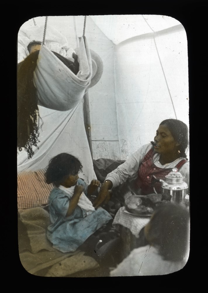
Indian tent. Mackenzie River. Note coffee percolator
https://archives.whyte.org/en/permalink/descriptions39463
- Part Of
- Moore family fonds
- Date Range
- 1899 - 1927
- Reference Code
- V439 / PS - 289
- Description Level
- 6 / Item
- GMD
- Photograph
- Lantern slide
- Transparency
1 image
- Part Of
- Moore family fonds
- Description Level
- 6 / Item
- Fonds Number
- M307 / V439
- Series
- I. Philip Moore series
- Sous-Fonds
- V439
- Sub-Series
- B. Professional papers and photographs 2. Research, writing and lecturing d. Photographs i. Lantern slides (transparencies)
- Reference Code
- V439 / PS - 289
- Date Range
- 1899 - 1927
- Physical Description
- 1 transparency : lantern slide
- Subject Access
- Buildings and memorials
- Discovery and Exploration
- Family and personal life
- First nations
- Geographic Access
- Northwest Territories
- Processing Status
- Processed
Images
This material is presented as originally created; it may contain outdated cultural descriptions and
potentially offensive content.
Read more.
Personal Documents
https://archives.whyte.org/en/permalink/descriptions23022
- Part Of
- Hans Gmoser fonds
- Scope & Content
- One of three files pertaining to Personal Documents.
- Date Range
- 1880-2013
- Reference Code
- M224 / 30
- Description Level
- 5 / File
- Part Of
- Hans Gmoser fonds
- Description Level
- 5 / File
- Series
- IV.C. Textual records
- Accession Number
- 8111
- Reference Code
- M224 / 30
- Date Range
- 1880-2013
- Physical Description
- 2 cm of textual records.
- Scope & Content
- One of three files pertaining to Personal Documents.
- Subject Access
- Discovery and Exploration
- Environment and Nature
- Family and personal life
- Sports and Recreation
- Title Source
- Supplied title.
- Content Details
- Canadian Passport July 15, 1983-July 15, 1988 Canadian Passport June 30, 1988- June 30, 1993 Canadian Passport April 6, 1993-April 6, 1998 Canadian Passport Feb 18, 1998-Feb 18, 2003 Photocopy of Johann Wolfgang Gmoser’s Canadian Passport Jan 28, 2003-2008. Photocopy of Johann Wolfgang Gmoser’s Austrian Passport February 3, 2003-2013 Photocopy of passport? From an individual born in 1880.
- Processing Status
- Processed
This material is presented as originally created; it may contain outdated cultural descriptions and
potentially offensive content.
Read more.
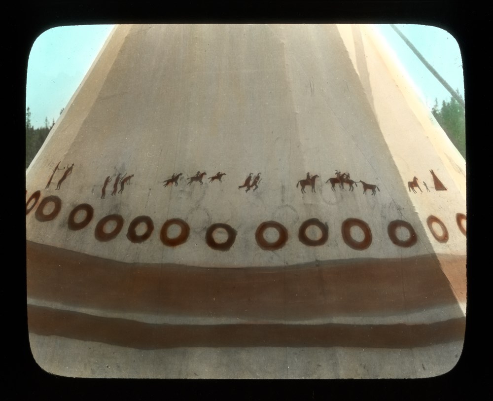
- Part Of
- Moore family fonds
- Date Range
- 1899 - 1927
- Reference Code
- V439 / PS - 323
- Description Level
- 6 / Item
- GMD
- Photograph
- Lantern slide
- Transparency
1 image
- Part Of
- Moore family fonds
- Description Level
- 6 / Item
- Fonds Number
- M307 / V439
- Series
- I. Philip Moore series
- Sous-Fonds
- V439
- Sub-Series
- B. Professional papers and photographs 2. Research, writing and lecturing d. Photographs i. Lantern slides (transparencies)
- Reference Code
- V439 / PS - 323
- Date Range
- 1899 - 1927
- Physical Description
- 1 transparency : lantern slide
- Subject Access
- Arts
- Buildings and memorials
- Discovery and Exploration
- First nations
- Geographic Access
- Alberta
- British Columbia
- Processing Status
- Processed
Images
This material is presented as originally created; it may contain outdated cultural descriptions and
potentially offensive content.
Read more.