Narrow Results By
The Balkans, Yugoslavia, Austria, Romania, Bulgaria
https://archives.whyte.org/en/permalink/catalogue24863
- Medium
- Library - Maps and blueprints (unannotated; published)
- Map
- Published Date
- 1962
- Publisher
- National Geographic Society
- Call Number
- C13-12.16
- Publisher
- National Geographic Society
- Published Date
- 1962
- Scale
- Scale: 34 miles to 1 inch
- Relief: Bench marks
- Subjects
- Europe - Central and Eastern
- Accession Number
- 495
- Call Number
- C13-12.16
- Collection
- Archives Library
This material is presented as originally created; it may contain outdated cultural descriptions and
potentially offensive content.
Read more.
- Subjects
- Europe - Western
- Notes
- The Irish Sea, The German Sea. The British Ocean
- Accession Number
- 400
- Call Number
- C13-12.7
- Collection
- Archives Library
This material is presented as originally created; it may contain outdated cultural descriptions and
potentially offensive content.
Read more.
Classical Lands of the Mediterranean
https://archives.whyte.org/en/permalink/catalogue24862
- Medium
- Library - Maps and blueprints (unannotated; published)
- Map
- Published Date
- 1940
- Publisher
- National Geographic Society
- Call Number
- C13-12.14
- Publisher
- National Geographic Society
- Published Date
- 1940
- Scale
- Scale: 35 miles to 1 inch
- Relief: Bench mark
- Subjects
- Europe - Southern
- Accession Number
- 495
- Call Number
- C13-12.14
- Collection
- Archives Library
This material is presented as originally created; it may contain outdated cultural descriptions and
potentially offensive content.
Read more.
- Date
- 1954 – 1959
- Material
- metal
- Catalogue Number
- 109.03.3001 a-d
- Description
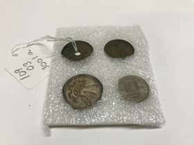
- Four foreign coins: (a) 2.5 cm dia. Round copper coin with hole in middle. Marked: "Rhodesia and Nyasaland one penny 1957” and on the reverse ”QUEEN ELIZABETH THE SECOND” with two elephants standing on thier hind legs below a crown. (b) 2.5 cm. dia. Copper coin marked: "Great Britain half pen…
1 image
- Title
- Coin
- Date
- 1954 – 1959
- Material
- metal
- Dimensions
- 2.5 (a,b); 2.3 (c); 2.8 (d) x 2.5 (a,b); 2.3 (c); 2.8 (d) cm
- Description
- Four foreign coins: (a) 2.5 cm dia. Round copper coin with hole in middle. Marked: "Rhodesia and Nyasaland one penny 1957” and on the reverse ”QUEEN ELIZABETH THE SECOND” with two elephants standing on thier hind legs below a crown. (b) 2.5 cm. dia. Copper coin marked: "Great Britain half penny 1959" with a boat, and on the reverse a right facing profile of Queen Elizabeth II with “+ ELIZABETH - II - DEI - GRATIA - REGINA - F - D” around the outer edge.(c) 2.3 cm. dia. Silver coloured coin with "Great Britian one shilling 1954 FID DEF" around a crest with rampant lion topped with a crown, and on the other side a profile of Queen Elizabeth and “REGINA + ELIZABETH - II - DEI GRATIA.” (d) 2.8 cm. dia. East European silver coin with two figures on one side with “henav zwelfhvn dert jahrfeier 754 - 1954” around the edge, and the side other has design of 3 sheaves and half a gear with “henav + algetshavsen + nieder - e oberstetten + stdzenberst + vzwil + neidervzwil” around the edge.
- Credit
- Gift of Catharine Robb Whyte, O. C., Banff, 1979
- Catalogue Number
- 109.03.3001 a-d
Images
This material is presented as originally created; it may contain outdated cultural descriptions and
potentially offensive content.
Read more.
Countries as established by the Peace Conference at Paris
https://archives.whyte.org/en/permalink/catalogue24855
- Medium
- Library - Maps and blueprints (unannotated; published)
- Map
- Published Date
- 1920
- Publisher
- National Geographic Society
- Call Number
- C13-12.2
- Publisher
- National Geographic Society
- Published Date
- 1920
- Scale
- 84 miles to 1 inch
- Subjects
- Europe
- Accession Number
- 400
- Call Number
- C13-12.2
- Collection
- Archives Library
This material is presented as originally created; it may contain outdated cultural descriptions and
potentially offensive content.
Read more.
Countries as established by the Peace Conference at Paris
https://archives.whyte.org/en/permalink/catalogue24856
- Medium
- Library - Maps and blueprints (unannotated; published)
- Map
- Published Date
- 1920
- Publisher
- National Geographic Society
- Call Number
- C13-12.2
- Publisher
- National Geographic Society
- Published Date
- 1920
- Scale
- 84 miles to 1 inch
- Subjects
- Europe
- Accession Number
- 400
- Call Number
- C13-12.2
- Collection
- Archives Library
This material is presented as originally created; it may contain outdated cultural descriptions and
potentially offensive content.
Read more.
Danubian Principalities
https://archives.whyte.org/en/permalink/catalogue21541
- Medium
- Library - Maps and blueprints (unannotated; published)
- Map
- Published Date
- 1854
- Publisher
- W and A.K. Johnston, Edinburgh
- Call Number
- C13-12.17
- Publisher
- W and A.K. Johnston, Edinburgh
- Published Date
- 1854
- Subjects
- Europe - Central & Eastern
- Accession Number
- 400
- Call Number
- C13-12.17
- Collection
- Archives Library
This material is presented as originally created; it may contain outdated cultural descriptions and
potentially offensive content.
Read more.
England and Wales
https://archives.whyte.org/en/permalink/catalogue24858
- Medium
- Library - Maps and blueprints (unannotated; published)
- Map
- Publisher
- Bacon and Co., London, England
- Call Number
- C13-12.6
- Publisher
- Bacon and Co., London, England
- Scale
- 8 miles - 1 inch
- Subjects
- Europe - Western
- Notes
- 2 sides
- Accession Number
- 400
- Call Number
- C13-12.6
- Collection
- Archives Library
This material is presented as originally created; it may contain outdated cultural descriptions and
potentially offensive content.
Read more.
[Europe and the Near East]
https://archives.whyte.org/en/permalink/catalogue24854
- Medium
- Library - Maps and blueprints (unannotated; published)
- Map
- Published Date
- 1929
- Publisher
- National Geographic Society
- Call Number
- C13-12.1
- Publisher
- National Geographic Society
- Published Date
- 1929
- Scale
- 94.7 miles to 1 inch
- Subjects
- Europe and the Near East
- Accession Number
- 400
- Call Number
- C13-12.1
- Collection
- Archives Library
This material is presented as originally created; it may contain outdated cultural descriptions and
potentially offensive content.
Read more.
- Subjects
- Europe - Western
- Notes
- Road map for North France and Belgium
- Accession Number
- 1195
- Call Number
- C13-12.12
- Collection
- Archives Library
This material is presented as originally created; it may contain outdated cultural descriptions and
potentially offensive content.
Read more.


