Narrow Results By
Travel journal, Canada and United States
https://archives.whyte.org/en/permalink/descriptions55621
- Part Of
- Luxton family fonds
- Scope & Content
- File consists of one bound journal containing an extensive account of a 4-month trip to Canada and the United States by [J?]. L. Douglass, August to December 1886.
- Date Range
- 1886
- Reference Code
- LUX / II / C6 / 2
- Description Level
- 5 / File
- GMD
- Textual record
- Part Of
- Luxton family fonds
- Description Level
- 5 / File
- Fonds Number
- LUX
- Series
- LUX / II / C : Personal
- Sous-Fonds
- LUX / II : Eleanor Luxton sous-fonds
- Sub-Series
- LUX / II / C6 : Southern Alberta research project
- Accession Number
- LUX
- Reference Code
- LUX / II / C6 / 2
- GMD
- Textual record
- Date Range
- 1886
- Physical Description
- 1.5 cm of textual records (1 volume ; 18 x 22 cm)
- Scope & Content
- File consists of one bound journal containing an extensive account of a 4-month trip to Canada and the United States by [J?]. L. Douglass, August to December 1886.
- Notes
- Volume accompanied by paper with shipping label dated 1956.
- Subject Access
- Travel
- Tourism
- Exploration
- Leisure
- Geographic Access
- Canada
- United States
- Language
- English
- Title Source
- Title based on contents of file
- Processing Status
- Processed
This material is presented as originally created; it may contain outdated cultural descriptions and
potentially offensive content.
Read more.
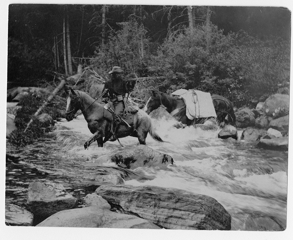
F.H. Riggall and packhourse crossing Boundary Creek
https://archives.whyte.org/en/permalink/descriptions53797
- Part Of
- Bert Riggall fonds
- Scope & Content
- Image depicts Bert Riggall and packhorse crossing Boundary Creek with Phillip R. Goodwin, artist of New York, in August, 1909.
- Date Range
- 1909
- Reference Code
- V26 / III / A1 / PA - 7
- Description Level
- 6 / Item
- GMD
- Photograph
- Photograph print
1 image
- Part Of
- Bert Riggall fonds
- Description Level
- 6 / Item
- Fonds Number
- M376 / V26
- Series
- III. Professional Photography: Guiding and Hunting Trips
- Sous-Fonds
- V26
- Sub-Series
- Goodwin and Proctor Trips
- Accession Number
- 7201
- Reference Code
- V26 / III / A1 / PA - 7
- Date Range
- 1909
- Physical Description
- 1 photograph : b&w print
- Scope & Content
- Image depicts Bert Riggall and packhorse crossing Boundary Creek with Phillip R. Goodwin, artist of New York, in August, 1909.
- Name Access
- Goodwin, Phillip R.
- Riggall, Bert
- Subject Access
- Environment and Nature
- Pack trips
- Exploration
- Horses
- Horse packing
- Geographic Access
- Canada
- British Columbia
- Boundary Creek
- Language
- N/A
- Title Source
- Title based on subject of item
- Processing Status
- Processed
Images
This material is presented as originally created; it may contain outdated cultural descriptions and
potentially offensive content.
Read more.
Bert Riggall's 1000 Mile Pack trip
https://archives.whyte.org/en/permalink/descriptions23454
- Part Of
- Bert Riggall fonds
- Scope & Content
- File consists of 43 b&w photographs, some captioned. Photographs pertain to Riggall's 1911 1000 mile pack trip undertaken to seek out areas for hunting and outfitting following the enlargement of Waterton National Park and the reduction of available hunting area for Riggall's clients. The prints do…
- Date Range
- 1911
- Reference Code
- V26 / II / A7 / PA - 119 to 161
- Description Level
- 5 / File
- GMD
- Photograph
- Photograph print
1 image
- Part Of
- Bert Riggall fonds
- Description Level
- 5 / File
- Fonds Number
- M376 / V26
- Series
- II.Business and Financial: Bert Riggall's 1000 Mile Pack trip, 1911
- Sous-Fonds
- V26
- Accession Number
- 7201
- Reference Code
- V26 / II / A7 / PA - 119 to 161
- Date Range
- 1911
- Physical Description
- 43 photographs: b&w prints
- Scope & Content
- File consists of 43 b&w photographs, some captioned. Photographs pertain to Riggall's 1911 1000 mile pack trip undertaken to seek out areas for hunting and outfitting following the enlargement of Waterton National Park and the reduction of available hunting area for Riggall's clients. The prints document this pack trip from stops in Banff, AB and Cranbrook, BC, and the extent of his mountain exploration from Fort Steele to Edson. On this trip, approximately 150 miles of new trail was cut including portions of Roger's Pass.
- Subject Access
- Pack trips
- Exploration
- Trails
- Trail making
- Recreation
- Hunting
- Outfitters, trail guides and packers
- Geographic Access
- Canada
- Alberta
- Banff National Park
- Waterton National Park
- British Columbia
- Cranbrook
- Rogers Pass
- Language
- English
- Title Source
- Title based on contents of file
- Processing Status
- Processed
Images

This material is presented as originally created; it may contain outdated cultural descriptions and
potentially offensive content.
Read more.
Bert Riggall's 1000 Mile Pack trip
https://archives.whyte.org/en/permalink/descriptions23455
- Part Of
- Bert Riggall fonds
- Scope & Content
- File consists of 20 b&w photographs, some captioned. Photographs pertain to Riggall's 1911 1000 mile pack trip undertaken to seek out areas for hunting and outfitting following the enlargement of Waterton National Park and the reduction of available hunting area for Riggall's clients. The prints do…
- Date Range
- 1911
- Reference Code
- V26 / II / A7 / PA - 162 to 181
- Description Level
- 5 / File
- GMD
- Photograph
- Photograph print
1 image
- Part Of
- Bert Riggall fonds
- Description Level
- 5 / File
- Fonds Number
- M376 / V26
- Series
- II.Business and Financial: Bert Riggall's 1000 Mile Pack trip, 1911
- Sous-Fonds
- V26
- Accession Number
- 7201
- Reference Code
- V26 / II / A7 / PA - 162 to 181
- Date Range
- 1911
- Physical Description
- Photographs: 20 prints, b&w
- Scope & Content
- File consists of 20 b&w photographs, some captioned. Photographs pertain to Riggall's 1911 1000 mile pack trip undertaken to seek out areas for hunting and outfitting following the enlargement of Waterton National Park and the reduction of available hunting area for Riggall's clients. The prints document this pack trip from stops in Banff, AB and Cranbrook, BC, and the extent of his mountain exploration from Fort Steele to Edson. On this trip, approximately 150 miles of new trail was cut including portions of Roger's Pass.
- Subject Access
- Pack trips
- Exploration
- Trails
- Trail making
- Recreation
- Hunting
- Outfitters, trail guides and packers
- Geographic Access
- Canada
- Alberta
- Banff National Park
- Waterton National Park
- British Columbia
- Cranbrook
- Rogers Pass
- Language
- English
- Title Source
- Title based on contents of file
- Processing Status
- Processed
Images
This material is presented as originally created; it may contain outdated cultural descriptions and
potentially offensive content.
Read more.
Mount Geikie ascent, 1924
https://archives.whyte.org/en/permalink/descriptions55250
- Part Of
- Malcolm Geddes fonds
- Scope & Content
- File consists of one copy of Good Roads magazine and 14 newspaper clippings from 1924 pertaining to the first ascent of Mount Geikie in 1924. First ascent was completed by members of the Alpine Club of Canada: Malcolm Geddes, Val Flynn and Cyril Wates.
- Date Range
- 1924
- Reference Code
- M39 / III / A / 1
- Description Level
- 5 / File
- GMD
- Textual record
- Published record
- Newspaper clipping
- Part Of
- Malcolm Geddes fonds
- Description Level
- 5 / File
- Fonds Number
- M39
- V756
- Series
- M39 / III : Personal and family records
- Sous-Fonds
- M39
- Sub-Series
- M39 / III / A : Travel and mountain expeditions
- Accession Number
- 2015.8558
- Reference Code
- M39 / III / A / 1
- Date Range
- 1924
- Physical Description
- 0.5 cm of textual records (1 volume : 20 x 27 cm -- 14 newspaper clippings)
- Scope & Content
- File consists of one copy of Good Roads magazine and 14 newspaper clippings from 1924 pertaining to the first ascent of Mount Geikie in 1924. First ascent was completed by members of the Alpine Club of Canada: Malcolm Geddes, Val Flynn and Cyril Wates.
- Notes
- Some items are annotated; newspaper clippings were originally stored between last two pages of magazine in file
- Name Access
- Geddes, Malcolm
- Flynn, Val
- Wates, Cyril
- Subject Access
- Summit
- Mountains
- Mountaineering
- Exploration
- Travel
- Geographic Access
- Canada
- British Columbia
- Mount Geikie
- Language
- English
- Category
- Exploration, discovery and travel
- Title Source
- Title based on contents of file
- Processing Status
- Processed
This material is presented as originally created; it may contain outdated cultural descriptions and
potentially offensive content.
Read more.
Mount Robson Ascent, 1924
https://archives.whyte.org/en/permalink/descriptions55261
- Part Of
- Malcolm Geddes fonds
- Scope & Content
- File consists of 3 photographs depicting Malcolm Geddes and several other members of the Alpine Club of Canada during an ascent of Mount Robson on July 25, 1924.
- Date Range
- 1924
- Reference Code
- V756 / III / A / PA - 25 to 27
- Description Level
- 5 / File
- GMD
- Photograph
- Photograph print
- Part Of
- Malcolm Geddes fonds
- Description Level
- 5 / File
- Fonds Number
- M39
- V756
- Series
- V756 / III : Personal and family records
- Sous-Fonds
- V756
- Sub-Series
- V756 / III / A : Travel and mountain expeditions
- Accession Number
- 2015.8558
- Reference Code
- V756 / III / A / PA - 25 to 27
- Date Range
- 1924
- Physical Description
- 3 photographs : b&w prints; 14 x 8 cm and 10.5 x 8 cm
- Scope & Content
- File consists of 3 photographs depicting Malcolm Geddes and several other members of the Alpine Club of Canada during an ascent of Mount Robson on July 25, 1924.
- Notes
- Item V756/III/A/PA-25 in file is accompanied by a note listing the names of all individuals in the photograph.
- Name Access
- Geddes, Malcolm
- Moffat, Thomas B.
- Buck, Annette
- Pollard, Harry
- Subject Access
- Alpine Club of Canada
- Hiking
- Mountains
- Mountaineering
- Climbing
- Recreation
- Exploration
- Geographic Access
- Canada
- British Columbia
- Mount Robson
- Language
- English
- Conservation
- Items stored in mylar
- Related Material
- Newspaper clippings pertaining to same ascent are stored in file M39/III/A/2
- Title Source
- Title based on contents of file
- Processing Status
- Processed
This material is presented as originally created; it may contain outdated cultural descriptions and
potentially offensive content.
Read more.
Mount Robson ascent, 1924
https://archives.whyte.org/en/permalink/descriptions55262
- Part Of
- Malcolm Geddes fonds
- Scope & Content
- File consists of 7 newspaper clippings pertaining to the third ascent of Mount Robson by Malcolm Geddes and other members of the Alpine Club of Canada on July 25, 1924.
- Date Range
- 1924
- Reference Code
- M39 / III / A / 2
- Description Level
- 5 / File
- GMD
- Textual record
- Published record
- Newspaper clipping
- Part Of
- Malcolm Geddes fonds
- Description Level
- 5 / File
- Fonds Number
- M39
- V756
- Series
- V756 / III : Personal and family records
- Sous-Fonds
- V756
- Sub-Series
- V756 / III / A : Travel and mountain expeditions
- Accession Number
- 2015.8558
- Reference Code
- M39 / III / A / 2
- Date Range
- 1924
- Physical Description
- 0.2 cm of textual records (7 newspaper clippings)
- Scope & Content
- File consists of 7 newspaper clippings pertaining to the third ascent of Mount Robson by Malcolm Geddes and other members of the Alpine Club of Canada on July 25, 1924.
- Name Access
- Geddes, Malcolm
- Kain, Conrad
- Moffat, Thomas B.
- Pollard, Harry
- Subject Access
- Hiking
- Climbing
- Mountains
- Mountaineering
- Alpine Club of Canada
- Exploration
- Recreation
- Publication
- Geographic Access
- Canada
- British Columbia
- Mount Robson
- Language
- English
- Related Material
- Photograph prints pertaining to same ascent are stored in file V756/III/A/PA-25 to 27
- Title Source
- Title based on contents of file
- Processing Status
- Processed
This material is presented as originally created; it may contain outdated cultural descriptions and
potentially offensive content.
Read more.
Jasper Institute 1994
https://archives.whyte.org/en/permalink/descriptions55997
- Part Of
- Ben Gadd fonds
- Scope & Content
- File consists of three transparency slide photographs sent to Ben Gadd from Dave Thomas. Images pertain to a five-day ecology course near Suplhur Skyline Trail and Geraldine Lakes Trail which Ben led through the Jasper Institute in 1994. Images in file are accompanied by a letter from Dave to Ben, …
- Date Range
- 1994
- Reference Code
- V810 / III / B / NS - 1 to 3
- Description Level
- 5 / File
- GMD
- Photograph
- Transparency
- Part Of
- Ben Gadd fonds
- Description Level
- 5 / File
- Fonds Number
- M590
- V810
- S61
- Series
- V810 / III : Professional records
- Sous-Fonds
- V810
- Sub-Series
- V810 / III / B : Interpretive guiding
- Accession Number
- 2021.20
- Reference Code
- V810 / III / B / NS - 1 to 3
- Responsibility
- Produced by Dave Thomas
- Date Range
- 1994
- Physical Description
- 3 photographs : col. transparency slides ; 35 mm -- 1 textual record
- Scope & Content
- File consists of three transparency slide photographs sent to Ben Gadd from Dave Thomas. Images pertain to a five-day ecology course near Suplhur Skyline Trail and Geraldine Lakes Trail which Ben led through the Jasper Institute in 1994. Images in file are accompanied by a letter from Dave to Ben, thanking him for leading the program.
- Name Access
- Gadd, Ben
- Thomas, Dave
- Subject Access
- Guiding
- Exploration
- Education
- Environment
- Ecology
- Hiking
- Trails
- Recreation
- Geographic Access
- Canada
- Alberta
- Jasper National Park
- Reproduction Restrictions
- Restrictions may apply
- Language
- English
- Title Source
- Title based on contents of file
- Processing Status
- Processed
This material is presented as originally created; it may contain outdated cultural descriptions and
potentially offensive content.
Read more.
West central Alberta interpretive signs
https://archives.whyte.org/en/permalink/descriptions55892
- Part Of
- Ben Gadd fonds
- Scope & Content
- File consists of records pertaining to a work project completed by Ben Gadd on behalf of the Alberta Environment Regional Support Branch, Central Alberta. File includes final text drafts of five interpretive signs written by Ben describing regions in west central Alberta, as well as suggested image…
- Date Range
- 2003
- Reference Code
- M590 / III / D / 11
- Description Level
- 5 / File
- GMD
- Textual record
- Part Of
- Ben Gadd fonds
- Description Level
- 5 / File
- Fonds Number
- M590
- V810
- S61
- Series
- M590 / III : Professional records
- Sous-Fonds
- M590
- Sub-Series
- M590 / III / D : Other contracts and projects
- Accession Number
- 2021.20
- Reference Code
- M590 / III / D / 11
- GMD
- Textual record
- Responsibility
- Interpretive text produced by Ben Gadd
- Date Range
- 2003
- Physical Description
- 0.2 cm of textual records
- Scope & Content
- File consists of records pertaining to a work project completed by Ben Gadd on behalf of the Alberta Environment Regional Support Branch, Central Alberta. File includes final text drafts of five interpretive signs written by Ben describing regions in west central Alberta, as well as suggested images to use for the signs; and faxed payment summaries and proof of payment which were sent to Ben.
- Name Access
- Gadd, Ben
- Mezerecky, Ken
- Subject Access
- Research
- Natural history
- Geology
- Tourism
- Hiking
- Caves
- Exploration
- Wildlife
- Recreation
- Pack trips
- Horse packing
- Horseback riding
- Geographic Access
- Canada
- Alberta
- Athabasca
- Cadomin
- Language
- English
- Related Material
- Corresponding photographs in V810 / III / D
- Title Source
- Title based on contents of file
- Processing Status
- Processed
This material is presented as originally created; it may contain outdated cultural descriptions and
potentially offensive content.
Read more.
Tommy and Lawrence: The Ways and the Trails of Lake O'Hara - textual
https://archives.whyte.org/en/permalink/descriptions55065
- Part Of
- Chic Scott fonds
- Scope & Content
- Series consists of textual records pertaining to the creation of Tommy and Lawrence [later edition]; includes notes, correspondence and other related materials.
- Date Range
- 2019
- Reference Code
- M57 / X
- Description Level
- 3 / Series
- GMD
- Textual record
- Part Of
- Chic Scott fonds
- Description Level
- 3 / Series
- Fonds Number
- M57 / V40 / S47
- Series
- M57 / X : Tommy and Lawrence: The Ways and the Trails of Lake O'Hara
- Sous-Fonds
- M57
- Sub-Series
- M57 / X / A: Manuscript Draft
- M57 / X / B: Correspondence
- M57 / X / C: Invoices
- M57 / X / D: Notes
- Accession Number
- .
- Reference Code
- M57 / X
- GMD
- Textual record
- Date Range
- 2019
- Physical Description
- 3 cm of textual records
- History / Biographical
- In 2010 Assiniboine Publishing undertook to reissue, on behalf of the Lake O'Hara Trails Club, Tommy and Lawrence, the Ways and the Trails of Lake O'Hara. Published originally in 1983, this book tells the story of George K. K. 'Tommy' Link and Lorenzo 'Lawrence' Grassi, the two colourful individuals who designed and built the majority of the trails at Lake O'Hara. No digital material was available from the first edition so it was necessary to completely rebuild the book adding many new photographs and a map of the Lake O'Hara region.
- Scope & Content
- Series consists of textual records pertaining to the creation of Tommy and Lawrence [later edition]; includes notes, correspondence and other related materials.
- Notes
- Series consists of four sub-series: M57 / X / A: Manuscript Draft M57 / X / B: Correspondence M57 / X / C: Invoices M57 / X / D: Notes
- Name Access
- Scott, Chic
- Link, George K. K. (Tommy)
- Grassi, Lawrence
- Subject Access
- Trails
- Trail making
- Biography
- Environment
- History
- Publication
- Research
- Exploration
- Geographic Access
- Canada
- Alberta
- Banff National Park
- Lake O'Hara
- Language
- English
- Biographical Source Notes
- http://chicscott.com/books.htm
- Title Source
- Title based on contents of file
- Processing Status
- Processed
This material is presented as originally created; it may contain outdated cultural descriptions and
potentially offensive content.
Read more.