Narrow Results By
Trail Riders of the Canadian Rockies fonds
https://archives.whyte.org/en/permalink/descriptions14160
- Scope & Content
- Fonds consists of organizational records including photographs, brochures, correspondence and other documents which are divided into five series [see Content Details]. Content pertains to the Trail Riders of the Canadian Rockies, including the organization's history, members and staff, trail rides …
- Date Range
- [ca.1924]-2013
- Reference Code
- M545 / V635
- Description Level
- 1 / Fonds
- GMD
- Photograph
- Album
- Negative
- Photograph print
- Transparency
- Film
- Motion picture
- Textual record
- Organization record
- Published record
- Description Level
- 1 / Fonds
- Fonds Number
- M545 / V635
- Sous-Fonds
- M545
- V635
- Accession Number
- 5757
- 5939
- 8235
- 2014.8277
- 2022.22
- Reference Code
- M545 / V635
- GMD
- Photograph
- Album
- Negative
- Photograph print
- Transparency
- Film
- Motion picture
- Textual record
- Organization record
- Published record
- Responsibility
- Trail Riders of the Canadian Rockies
- Date Range
- [ca.1924]-2013
- Physical Description
- ca.340 cm of textual records -- 1191 photographs (691 prints, 312 transparencies, 188 negatives) -- 11 photograph albums -- 4 motion pictures -- 7 discs (1,214 digital images, 1 slideshow)
- History / Biographical
- The Trail Riders of the Canadian Rockies is a trail riding organization based in Calgary, Alberta. The organization was established in 1923 with the support of the Canadian Pacific Railway. The first ride was held in 1924, and annual summer trail rides and pow-wows attracted fifteen hundred members by 1929. Many notable residents of the Bow Valley, including members of the Brewster and Moore families, Catherine Robb and Peter Whyte, and Carl Rungius have participated in trail rides. Support from the Canadian Pacific Railway ended in 1961. As of 2020, the Trail Riders of the Canadian Rockies remains an active organization. LISTING OF TRAIL RIDE LOCATIONS: 1924 : Yoho Valley 1925 : Marble Canyon, Wolverine Plateau, Goodsir Plateau, Lake O'Hara, Lake Wapta, Sun Dance Lodge 1926 : Baker Lake, Shaki, Molar Peak, Bow Lake, Mosquito Creek, Ptarmigan Valley 1927 : Mountain Assiniboine, Brewster Creek, Magag Lake, Sunshine Camp, Simpson Pass; Jasper, Portal Creek, Maccarib Pass, Tonquin Valley, Meadow Creek, Calendone River 1928 : Lake of Hanging Glaciers; Horse Thief Creek, Windermere 1929 : Egypt Lake, Shadow Lake, Twin Lake; Lake Louise, Columbia Icefields 1930 : Red Earth Creek, Hawk Creek, Floe Lake, Wolverine Pass, Marble Canyon 1931 : Bankhead, Cascade River, Stewart Canyon, Stoney Creek, Baker Creek, Sawback Lake 1932 : Mount Assiniboine and Banff Springs Hotel terrace (Pow-wow) 1933 : Mosquito Creek, Bow Lake, Isabella Lake, Pipestone River, Lake Louise 1934 : Leanchoil, Shining Beauty camp, Goodsir mountain, Wolverine Plateau, Marble Canyon 1935 : Windy Camp, Snow Creek Pass, Scotch Cabin, Baker Lake, Ptarmigan Valley, Lake Louise Station (pow-wow) 1936 : Johnston Canyon, Pulsatilla Mountain, Badger Pass, Forty Mile Creek, Hillsdale Meadows 1937 : Mount Assiniboine, Lake Magog, Valley of the Rocks, Simpson Pass, Healy Creek 1938 : Carrot Creek, Lake Minnewanka, Middle Lake, Devil Gap, Ghost River, Mount Aylmer, Aylmer Pass 1939 : Healy Creek, Egypt Lake, Scarab Lake, Shadow Lakes, Twin Lakes, Taylor Lake, Moraine Lake 1940 : Marble Canyon, Helmet Creek, Ottertail River, Lake McArthur, Chateau Lake Louise 1941 : Mount Assiniboine, Canmore, spray Lakes, Valley of Rocks, Simpson Summit, Rock Isle Lake, Healy Creek 1942 : Larix Lake, Egypt Lake, Twin Lakes, Storm Mountain 1943 : Healy Creek warden's cabin, Brewater Creek, Fatigue Pass, Quartz hill, Simpson Summit, Sunshine Lodge, Eohippus lake, Mount Assiniboine 1944 : Healy Creek, Brewster Creek, Quartz Hill, Lake Eohippus, Red Earth Creek 1945 : Baker Lake 1946 : Panther River (Windy Camp), Snow Creek, Harrison Lake, Panther Falls 1947 : Monard Mountain, Healy Creek, Redearth Creek 1948 : Sunshine and Simpson River 1949 : Molar Mountain area 1950 : Palliser Pass 1951 : Goodsirs 1952 : Harvey Pass, Healy Creek, Egypt Lake 1953 : Baker Lakes 1954 : Mount Assiniboine, Magog Lake 1955 : Pulsatilla Pass area 1956 : Pipestone area 1957 : Panther River, Windy Camp, Dormer Pass, Snow Creek 1958 : Mount Assiniboine 1959 : Palliser Pass area [Bunny Robinson paints new teepee designs] 1960 : Pipestone area, north of Lake Louise 1961 : Goodsirs Mountains, McArthur Creek, Wolverine Pass [Volume 102, CPR publication last issue - CPR pulls sponsorship of association] 1962 : Pipestone and Skoki Valley areas 1963 : Simpson Summit, Healy Creek, Harvey Pass, Egypt Lake 1964 : Bryant Creek Meadows, Mount Assiniboine 1965 : Palliser Pass 1966 : Ptarmigan Valley, north of Lake Louise 1967 : Palliser Pass 1968 : Bryant Creek Meadows, Mount Assiniboine 1969 : Pulsatilla Pass 1970 : Egypt Lake area 1971 : Pipestone region 1972 : Shadow Lakes 1973 : Palliser Pass [50th anniversary] 1974 : Pulsatilla Pass area, Johnson Creek Meadows 1975 : Pipestone River area : Molar Glacier, Skoki Lakes, Merlin Lakes, hector Plateau, Fish Lakes 1976 : Cascade Valley region : Elk Lake summit, Stoney Creek, Dormer Pass 1977 : Mount Assiniboine 1978 : Palliser Pass area : Upper Spray River 1979 : Pulsatilla Pass area : Indian Paint Pots, Johnston Creek Meadows 1980 : Panther River region 1981 : Red Deer River region : Divide Creek, Tyrell Creek, Horseshoe Lake, Panther Ridge 1982 : Bryant Creek, Og Pass, Owl and Marvel Lakes, Allenby Pass, Assiniboine Pass, Lake Magog 1983 : Upper Pipestone River region: Red Deer Lake, Skoki Lakes, Hector Plateau, Singing Meadows [60th Anniversary] 1984 : Panther River region 1985 : Palliser Pass : Goat Ridge, Tumble Creek Falls, Spray Lakes, Birdwood Mountain, Leman Lake, White Man Pass 1986 : Johnston Creek, Badger Pass and Pulsatilla Pass; Safari expeditions: Kananaskis Country, Pipestone River , Front Range, Clearwater, Kootenay Plains 1987 : Red Deer River 1988 : Pipestone River 1989 : Panther River 1990 : Palliser Pass 1991 : Red Deer River 1992 : Bryant Creek 1993 : Pipestone River 1994 : Johnston Creek 1995 : Palliser Pass 1996 : Red Deer River 1997 : Bryant Creek 1998 : Panther River 1999 : Pipestone River 2000 : Johnston Creek 2001 : Palliser Pass 2002 : Yamnuska and Ghost Mountain 2003 : Bryant Creek 2004 : Cascade Valley and Mystic Lake 2005 : Sundance and Halfway Lodge 2006 : Waterton Park 2007 : Clearwater River 2008 : Kananaskis 2009 : Johnston Creek 2010 : Stoney Creek and Flint's Valley 2011 : Rock Lake and Solomon Creek 2012 : Kananaskis 2013 : Bryant Creek
- Scope & Content
- Fonds consists of organizational records including photographs, brochures, correspondence and other documents which are divided into five series [see Content Details]. Content pertains to the Trail Riders of the Canadian Rockies, including the organization's history, members and staff, trail rides and other events, publications and advertising, finances, and administration.
- Notes
- Fonds has been reorganized by Processing Archivist Kate Skelton and content from all accessions prior to 2019 has been integrated into new series. Content from accessions 5757 and 5939 have been renumbered; storage of files adjusted to accommodate most recent donations [accn. 8235 & accn. 2014.8277]
- Some files contain personal contact information including full names, home addresses, email addresses and phone numbers [see file-level entries under M545/V635 for specific contents and restrictions]
- Material Details
- Textual records include oversize items
- Name Access
- Trail Riders of the Canadian Rockies
- Subject Access
- Exploration, discovery and travel
- Sports, recreation and leisure
- Administration
- Advertising
- Organizations
- Membership
- Businesses
- Pack trips
- Tourism
- Travel
- Legal and Financial
- Geographic Access
- Canada
- Alberta
- Banff
- Calgary
- Edmonton
- Canadian Rocky Mountains
- Access Restrictions
- Copyright and privacy restrictions may apply
- Reproduction Restrictions
- Copyright and privacy restrictions may apply
- Language
- English
- Finding Aid
- Arrangement outline, series description and file descriptions available. Online file inventory available
- Related Material
- Fonds was accompanied by non-annotated print material (transferred to library)
- Category
- Sports, recreation and leisure
- Exploration, discovery and travel
- Communications
- Government
- Natural resources
- Transportation
- Biographical Source Notes
- http://trailridevacations.com/history/?gclid=Cj0KCQjw0pfzBRCOARIsANi0g0sZ6TMtMbL992rp2rhrDrJ-NkaD8zp5ceBIf_LJGHjYk3_lg_l4zrIaAs3oEALw_wcB
- Title Source
- Title based on contents of fonds
- Content Details
- Series I - Events and Activities: Records include ride notes and summaries [1968-2009], songs and poems performed during trail rides, documents and images pertaining to the Townsend Trophy photograph competition, and materials related to other events including trail ride anniversary events and round-ups. Series II - Members, Staff, Personal Content : Records include lists of trail ride participants, documents from camp coordinators and other trail ride staff, personal photographs, committee notes, personal correspondence and trail ride surveys from 1958-2009 Series III - Published Records : Records include newsletters, brochures, promotional material, news articles and other published content Series IV - Financial Records : Records include tax records, income statements, expense notes, receipts, payment information for members, budgets, price lists and funding applications Series V - Administrative Records : Records include administrative notes, inventories and checklists, meeting minutes and agendas, legal and administrative forms, and agreements with outfitting and supply companies
- Processing Status
- Processed
This material is presented as originally created; it may contain outdated cultural descriptions and
potentially offensive content.
Read more.
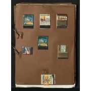
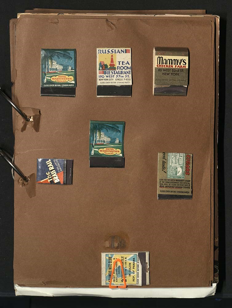
Travel scrapbook
https://archives.whyte.org/en/permalink/descriptions54625
- Part Of
- Luxton family fonds
- Scope & Content
- File consists of one travel scrapbook, with various materials including matchboxes, souvenir napkins, booklets and brochures, menus, advertisements, event programs, magazines, maps and travel guides, and one photograph. Content pertains to Eleanor Luxton's travels to the New York World Fair in 1939…
- Date Range
- [ca. 1935 - ca. 1940]
- 1939
- Reference Code
- LUX / II / E / 4
- Description Level
- 5 / File
- GMD
- Scrapbook
- Textual record
- Published record
- Photograph
- Photograph print
1 image
1 Electronic Resource
- Part Of
- Luxton family fonds
- Description Level
- 5 / File
- Fonds Number
- LUX
- Series
- LUX / II / E : Travel and home records
- Sous-Fonds
- LUX / II : Eleanor Luxton
- Accession Number
- LUX
- Reference Code
- LUX / II / E / 4
- Date Range
- [ca. 1935 - ca. 1940]
- 1939
- Physical Description
- 6 cm of textual records -- 1 photograph : b&w print ; 20 x 25 cm on matboard
- Scope & Content
- File consists of one travel scrapbook, with various materials including matchboxes, souvenir napkins, booklets and brochures, menus, advertisements, event programs, magazines, maps and travel guides, and one photograph. Content pertains to Eleanor Luxton's travels to the New York World Fair in 1939, as well as Winnipeg, Montreal, Chicago, Panama and Havana, Cuba around the same time period. Includes image of Eleanor [far right] sitting with three unidentified friends at Sloppy Joe's Bar in Havana.
- Material Details
- Scrapbook has no cover or bindings
- Name Access
- Luxton, Eleanor
- Subject Access
- Travel
- Tourism
- Family and personal life
- Events
- Advertising
- Businesses
- Music
- Arts
- Geographic Access
- Canada
- Manitoba
- Winnipeg
- Quebec
- Montreal
- United States of America
- Panama
- Cuba
- Havana
- Access Restrictions
- Access to original copy may be restricted due to poor condition
- Reproduction Restrictions
- Restrictions may apply
- Language
- English
- Conservation
- Materials held together with unbleached cotton string
- Use of original copy not recommended as there are many loose contents and small items which can be lost or misplaced in scrapbook. Once item has been digitized, access to original may be further restricted for preservation reasons
- Title Source
- Title based on contents of file
- Processing Status
- Processed
Electronic Resources
Images
This material is presented as originally created; it may contain outdated cultural descriptions and
potentially offensive content.
Read more.
Byron Harmon photograph calendars
https://archives.whyte.org/en/permalink/descriptions54723
- Part Of
- Luxton family fonds
- Scope & Content
- File consists of 5 commercial miniature calendars with photographs [one printed directly onto calendar, 4 attached to backing]. Photographs on calendars are by Byron Harmon [one is not attributed, but likely by Harmon as well], and pertain to: an unnamed Indigenous couple [possibly Stoney Nakoda co…
- Date Range
- 1907
- 1912
- Reference Code
- LUX / II / F1 / 26
- Description Level
- 5 / File
- GMD
- Calendar
- Textual record
- Published record
- Photograph
- Photograph print
- Part Of
- Luxton family fonds
- Description Level
- 5 / File
- Fonds Number
- LUX
- Series
- LUX / II / F : Collected material
- Sous-Fonds
- LUX / II : Eleanor Luxton sous-fonds
- Sub-Series
- LUX / II / F1 : Textual
- Accession Number
- LUX
- Reference Code
- LUX / II / F1 / 26
- Responsibility
- Photographs attributed to Byron Harmon
- Date Range
- 1907
- 1912
- Physical Description
- 5 calendars (17.8 x 36.5 cm or smaller)
- Scope & Content
- File consists of 5 commercial miniature calendars with photographs [one printed directly onto calendar, 4 attached to backing]. Photographs on calendars are by Byron Harmon [one is not attributed, but likely by Harmon as well], and pertain to: an unnamed Indigenous couple [possibly Stoney Nakoda community members], a view of Maligne Lake, an unidentified mountain, 4 ice climbers at the peak of Mt. Habel, and Stoney hunter and Trapper Silas Abraham. Calendar depicting Silas Abraham, 1907, includes printed advertisement for Norman Luxton's trading and taxidermy businesses in Banff and Exshaw.
- Name Access
- Harmon, Byron
- Luxton, Norman
- Subject Access
- Advertising
- Banff National Park
- Landscapes
- Mountain
- Hotel
- Indigenous Peoples
- Businesses
- Trapping
- Tourism
- Taxidermy
- Geographic Access
- Canada
- Alberta
- Banff
- Exshaw
- Jasper National Park
- Maligne Lake
- Mount Habel
- Access Restrictions
- Restrictions may apply
- Language
- English
- Conservation
- Items have been placed in mylar sheets
- Title Source
- Title based on contents of file
- Processing Status
- Processed
This material is presented as originally created; it may contain outdated cultural descriptions and
potentially offensive content.
Read more.
Baja California Sur, Mexico
https://archives.whyte.org/en/permalink/descriptions54835
- Part Of
- Murray Hay fonds
- Scope & Content
- File consists of 1 cm of textual records, 21.5 x 36 cm or smaller. File pertains to a project Murray Hay worked on for Glacier Bay Tours and Cruises (based out of Alaska). File is comprised of handwritten and faxed correspondence between Hay and Steve Cowart, Manager, Creative Services. Corresponde…
- Date Range
- ca.1998
- Reference Code
- M570 / IV / A / 1
- Description Level
- 5 / File
- GMD
- Textual record
- Private record
- Map
- Part Of
- Murray Hay fonds
- Description Level
- 5 / File
- Fonds Number
- M570 / V795
- Series
- M570 / IV : Murray Hay Personal Papers
- Sous-Fonds
- M570
- Sub-Series
- M570 / IV / A : Correspondence
- Accession Number
- 2019.41
- Reference Code
- M570 / IV / A / 1
- Date Range
- ca.1998
- Physical Description
- 1 cm of textual records (21.5 x 36 cm or smaller)
- Scope & Content
- File consists of 1 cm of textual records, 21.5 x 36 cm or smaller. File pertains to a project Murray Hay worked on for Glacier Bay Tours and Cruises (based out of Alaska). File is comprised of handwritten and faxed correspondence between Hay and Steve Cowart, Manager, Creative Services. Correspondence is in regards to the map of Baja California Sur, Mexico Hay was to create for the company's promotion of their cruise to the area.
- Notes
- Originally filed with draft material related to this project [see related material].
- Name Access
- Hay, Murray
- Cowart, Steve
- Subject Access
- Advertising
- Artist
- Cartography
- Map
- Tourism
- Travel
- Tourist information
- Geographic Access
- Mexico
- Baja California Sur
- Language
- English
- Related Material
- V795 / II / D / ii / 2-3
- Title Source
- Title based on contents of file
- Processing Status
- Processed
This material is presented as originally created; it may contain outdated cultural descriptions and
potentially offensive content.
Read more.
- Part Of
- Murray Hay fonds
- Scope & Content
- File consists of 2 cm of textual records, 43 x 28 cm, or smaller. File pertains to Murray Hay's work on various projects in Alaska, USA, specifically the Mount Roberts Tramway in Juneau and Anchorage's Olympic Bid for the 1992 Winter Olympics. File includes a map and/or illustration of the Mount Ro…
- Date Range
- ca.1980-1997
- 1996
- 1997
- Reference Code
- M570 / IV / A / 2-3
- Description Level
- 5 / File
- GMD
- Textual record
- Private record
- Map
- Part Of
- Murray Hay fonds
- Description Level
- 5 / File
- Fonds Number
- M570 / V795
- Series
- M570 / IV : Murray Hay Personal Papers
- Sous-Fonds
- M570
- Sub-Series
- M570 / IV / A : Correspondence
- Accession Number
- 2019.41
- Reference Code
- M570 / IV / A / 2-3
- Date Range
- ca.1980-1997
- 1996
- 1997
- Physical Description
- 2 cm of textual records (43 x 28 cm or smaller)
- Scope & Content
- File consists of 2 cm of textual records, 43 x 28 cm, or smaller. File pertains to Murray Hay's work on various projects in Alaska, USA, specifically the Mount Roberts Tramway in Juneau and Anchorage's Olympic Bid for the 1992 Winter Olympics. File includes a map and/or illustration of the Mount Roberts Tramway in Juneau, Alaska; handwritten correspondence between Hay and "Ms. Hunter" and the mailing slip (1997); a rough sketch of Hay's illustrations; tourism information related to the Mount Roberts Tramway; and correspondence and a draft example of the map for the Olympic Bid.
- Notes
- The Mount Roberts Tramway has been in operation since 1996.
- M570 / IV / A / 3 : date based on the potential connection between the records and the Olympic bid process for the 1992 Winter Olympics, for which Anchorage (Alyeska) submitted a bid using maps created by Murray Hay. The selection was determined in 1986.
- Records were originally filed in two envelopes, labelled: "Mt. Roberts Trmw." and "Prince William Sound - Valdez." File titles reflect this.
- Name Access
- Hay, Murray
- Subject Access
- Advertising
- Artist
- Cartography
- Discovery and travel
- Leisure
- Map
- Tourism
- Tourist information
- Travel
- Ski area
- Ski Maps
- Sports and recreation
- Winter
- Winter sports
- Olympic Games (Winter)
- Geographic Access
- Alaska
- United States of America
- Juneau
- Valdez
- Prince William Sound
- Language
- English
- Title Source
- Title based on contents of file
- Processing Status
- Processed
This material is presented as originally created; it may contain outdated cultural descriptions and
potentially offensive content.
Read more.
- Part Of
- Murray Hay fonds
- Scope & Content
- File consists of 8 colour prints, 28 x 35 cm or smaller. File pertains to Murray Hay's work for the City of Kimberley, British Columbia. File includes prints of original paintings done by Hay relating to a proposed real estate development in the city and the Kimberley ski hill.
- Date Range
- ca.1979-ca.2000
- Reference Code
- V795 / II / A / iii / 1-2
- Description Level
- 5 / File
- GMD
- Map
- Private record
- Part Of
- Murray Hay fonds
- Description Level
- 5 / File
- Fonds Number
- M570 / V795
- Series
- V795 / II : Unpublished Material
- Sous-Fonds
- V795
- Sub-Series
- V795 / II / A : British Columbia / iii : Kimberley
- Accession Number
- 2019.41
- Reference Code
- V795 / II / A / iii / 1-2
- GMD
- Map
- Private record
- Date Range
- ca.1979-ca.2000
- Physical Description
- 8 prints : col. ; 28 x 35 cm or smaller
- Scope & Content
- File consists of 8 colour prints, 28 x 35 cm or smaller. File pertains to Murray Hay's work for the City of Kimberley, British Columbia. File includes prints of original paintings done by Hay relating to a proposed real estate development in the city and the Kimberley ski hill.
- Notes
- The ski hill at Kimberley was developed in 1979.
- Most of the prints are annotated in ink by Hay (his own notes and comments by clients).
- Name Access
- Hay, Murray
- Subject Access
- Advertising
- Artist
- Art
- Cartography
- Community life
- Landscapes
- Map
- Mountains
- Municipal views
- Ski area
- Ski Maps
- Sports and recreation
- Tourism
- Tourist information
- Winter
- Kimberley Alpine Resort
- Geographic Access
- Kimberley
- British Columbia
- Canada
- Purcell Mountains
- Language
- English
- Conservation
- There is masking tape holding some of the prints together on a piece of paper, which should be removed and alternative preservation methods should be considered at a reasonable time to do so.
- Creator
- Hay, Murray
- Title Source
- Title based on contents of file
- Processing Status
- Processed
This material is presented as originally created; it may contain outdated cultural descriptions and
potentially offensive content.
Read more.
Powder King Ski Village
https://archives.whyte.org/en/permalink/descriptions54878
- Part Of
- Murray Hay fonds
- Scope & Content
- File consists of 4 prints : col. ; 35 x 28 cm or smaller. File pertains to Murray Hay's rendering of the lift system at Powder King Ski Village in British Columbia. File includes different iterations of a map of the lift system, all reproduced as draft prints.
- Date Range
- ca.1980-ca.1985
- ca.1983
- Reference Code
- V795 / II / A / v / 1-2
- Description Level
- 5 / File
- GMD
- Map
- Private record
- Part Of
- Murray Hay fonds
- Description Level
- 5 / File
- Fonds Number
- M570 / V795
- Series
- V795 / II : Unpublished Material
- Sous-Fonds
- V795
- Sub-Series
- V795 / II / A : British Columbia / v : Powder King Mountain Resort
- Accession Number
- 2019.41
- Reference Code
- V795 / II / A / v / 1-2
- GMD
- Map
- Private record
- Date Range
- ca.1980-ca.1985
- ca.1983
- Physical Description
- 4 prints : col. ; 35 x 28 cm or smaller
- Scope & Content
- File consists of 4 prints : col. ; 35 x 28 cm or smaller. File pertains to Murray Hay's rendering of the lift system at Powder King Ski Village in British Columbia. File includes different iterations of a map of the lift system, all reproduced as draft prints.
- Notes
- The ski hill was renamed Powder King in 1983.
- One of the prints in V795 / II / A / v / 1 include a sticky note with annotations and has comments on the actual print itself in red ink.
- Name Access
- Hay, Murray
- Subject Access
- Advertising
- Art
- Artist
- Ski Maps
- Map
- Cartography
- Sports and recreation
- Tourism
- Tourist information
- Winter
- Winter sports
- Ski area
- Powder King Mountain Resort
- Geographic Access
- British Columbia
- Canada
- Powder King Mountain Resort
- Language
- English
- Creator
- Hay, Murray
- Title Source
- Title based on contents of file
- Processing Status
- Processed
This material is presented as originally created; it may contain outdated cultural descriptions and
potentially offensive content.
Read more.
- Part Of
- Murray Hay fonds
- Scope & Content
- File consists of 5 prints : b&w and col. ; 38 x 26.5 cm or smaller. FIle pertains to Murray Hay's work on different maps for a variety of places in British Columbia, Canada. File includes three draft prints of different iterations of the ski trails at the Fairmont Hot Springs resort; a map labelled…
- Date Range
- ca.1976-ca.2000
- Reference Code
- V795 / II / A / viii / 1-3
- Description Level
- 5 / File
- GMD
- Private record
- Map
- Part Of
- Murray Hay fonds
- Description Level
- 5 / File
- Fonds Number
- M570 / V795
- Series
- V795 / II : Unpublished Material
- Sous-Fonds
- V795
- Sub-Series
- V795 / II / A : British Columbia / viii : Miscellaneous
- Accession Number
- 2019.41
- Reference Code
- V795 / II / A / viii / 1-3
- GMD
- Private record
- Map
- Date Range
- ca.1976-ca.2000
- Physical Description
- 5 prints : b&w and col. ; 38 x 26.5 cm or smaller
- Scope & Content
- File consists of 5 prints : b&w and col. ; 38 x 26.5 cm or smaller. FIle pertains to Murray Hay's work on different maps for a variety of places in British Columbia, Canada. File includes three draft prints of different iterations of the ski trails at the Fairmont Hot Springs resort; a map labelled in pencil (on the back of the print) "Cypress Bowl Cross Country Ski Map - Vancouver", and a map glued or otherwise attached to a piece of white board labelled in blue ink "Blue River Heli Ski Area (approximately the size of Belgium."
- Name Access
- Hay, Murray
- Subject Access
- Advertising
- Artist
- Ski area
- Ski Maps
- Map
- Cartography
- Sports and recreation
- Tourism
- Tourist information
- Helicopter skiing
- Winter
- Winter sports
- Geographic Access
- Vancouver
- Fairmont Hot Springs
- Blue River Resort
- British Columbia
- Canada
- Language
- English
- Conservation
- Adhesives should be removed and alternative preservation methods should be used.
- Related Material
- M570 / III / A / vi / 1
- Creator
- Hay, Murray
- Title Source
- Title based on contents of file
- Processing Status
- Processed
This material is presented as originally created; it may contain outdated cultural descriptions and
potentially offensive content.
Read more.
- Part Of
- Murray Hay fonds
- Scope & Content
- File consists of 2 prints : col. ; 35 x 28 cm. File pertains to Murray Hay's rendering of Marmot Basin ski area in Jasper National Park. File includes two iterations of reproduction draft prints of Hay's map of Marmot Basin.
- Date Range
- ca.1976-ca.2000
- Reference Code
- V795 / II / B / i / 1
- Description Level
- 5 / File
- GMD
- Map
- Private record
- Part Of
- Murray Hay fonds
- Description Level
- 5 / File
- Fonds Number
- M570 / V795
- Series
- V795 / II : Unpublished Material
- Sous-Fonds
- V795
- Sub-Series
- V795 / II / B : Alberta / i : Jasper National Park
- Accession Number
- 2019.41
- Reference Code
- V795 / II / B / i / 1
- GMD
- Map
- Private record
- Date Range
- ca.1976-ca.2000
- Physical Description
- 2 prints : col. ; 35 x 28 cm
- Scope & Content
- File consists of 2 prints : col. ; 35 x 28 cm. File pertains to Murray Hay's rendering of Marmot Basin ski area in Jasper National Park. File includes two iterations of reproduction draft prints of Hay's map of Marmot Basin.
- Name Access
- Hay, Murray
- Subject Access
- Advertising
- Artist
- Ski Maps
- Ski area
- Map
- Cartography
- Sports and recreation
- Tourism
- Tourist information
- Winter
- Winter sports
- Geographic Access
- Jasper Marmot Basin
- Jasper National Park
- Alberta
- Canada
- Canadian Rocky Mountains
- Language
- English
- Related Material
- M570 / III / B / iii / 1
- Creator
- Hay, Murray
- Title Source
- Title based on contents of file
- Processing Status
- Processed
This material is presented as originally created; it may contain outdated cultural descriptions and
potentially offensive content.
Read more.
Lake Louise Area
https://archives.whyte.org/en/permalink/descriptions54925
- Part Of
- Murray Hay fonds
- Scope & Content
- File consists of 6 prints : col. ; 25.5 x 20 cm or smaller. File pertains to Murray Hay's renderings of the Lake Louise ski area. File includes six reproduced draft prints of original paintings of the Lake Louise ski area created by Murray Hay (different iterations).
- Date Range
- ca.1976-ca.2000
- Reference Code
- V795 / II / B / ii / 1
- Description Level
- 5 / File
- GMD
- Map
- Private record
- Part Of
- Murray Hay fonds
- Description Level
- 5 / File
- Fonds Number
- M570 / V795
- Series
- V795 / I : Unpublished Material
- Sous-Fonds
- V795
- Sub-Series
- V795 / I / B : Alberta / ii : Lake Louise
- Accession Number
- 2019.41
- Reference Code
- V795 / II / B / ii / 1
- GMD
- Map
- Private record
- Date Range
- ca.1976-ca.2000
- Physical Description
- 6 prints : col. ; 25.5 x 20 cm or smaller
- Scope & Content
- File consists of 6 prints : col. ; 25.5 x 20 cm or smaller. File pertains to Murray Hay's renderings of the Lake Louise ski area. File includes six reproduced draft prints of original paintings of the Lake Louise ski area created by Murray Hay (different iterations).
- Name Access
- Hay, Murray
- Subject Access
- Advertising
- Artist
- Ski Maps
- Map
- Cartography
- Sports and recreation
- Tourism
- Tourist information
- Winter
- Winter sports
- Ski area
- Lake Louise Ski Area
- Geographic Access
- Lake Louise
- Alberta
- Canada
- Canadian Rocky Mountains
- Language
- English
- Related Material
- M570 / III / B / ii / 1-2
- Creator
- Hay, Murray
- Title Source
- Title based on contents of file
- Processing Status
- Processed
This material is presented as originally created; it may contain outdated cultural descriptions and
potentially offensive content.
Read more.