Narrow Results By
Maps of Banff and Western Canada
https://archives.whyte.org/en/permalink/descriptions54772
- Part Of
- Luxton family fonds
- Scope & Content
- File consists of 9 printed maps, b&w and col. [including zoning and topographical maps] depicting the Town of Banff and Banff National Park, the Rocky Mountains Forest Reserve, the Moose Mountain region, Medicine Hat, and the province of Alberta. File includes Trail Riders' Map of the Canadian Rock…
- Date Range
- 1912
- 1914
- 1924
- 1926
- 1932
- 1957
- [1970-1980]
- Reference Code
- LUX / II / C5 / 25
- Description Level
- 5 / File
- GMD
- Textual record
- Published record
- Map
- Part Of
- Luxton family fonds
- Description Level
- 5 / File
- Fonds Number
- LUX
- Series
- LUX / II / C : Personal
- Sous-Fonds
- LUX / II : Eleanor Luxton sous-fonds
- Sub-Series
- LUX / II / C5 : Other
- Accession Number
- LUX
- Reference Code
- LUX / II / C5 / 25
- Date Range
- 1912
- 1914
- 1924
- 1926
- 1932
- 1957
- [1970-1980]
- Physical Description
- 9 maps : b&w and col. ; 168 x 71 cm or smaller
- Scope & Content
- File consists of 9 printed maps, b&w and col. [including zoning and topographical maps] depicting the Town of Banff and Banff National Park, the Rocky Mountains Forest Reserve, the Moose Mountain region, Medicine Hat, and the province of Alberta. File includes Trail Riders' Map of the Canadian Rockies which has smaller maps of Waterton Lakes, Glacier, Revelstoke, and other national parks printed on the back. Map of Medicine Hat includes annotated storage envelope with dimensions written on the front.
- Subject Access
- Cartography
- Geography
- Land use
- Government
- Travel
- National parks and reserves
- Geographic Access
- Canada
- Alberta
- Banff
- Banff National Park
- Medicine Hat
- Rocky Mountains
- Glacier National Park
- Revelstoke
- Waterton Lakes National Park
- Reproduction Restrictions
- Restrictions may apply
- Language
- English
- Title Source
- Title based on contents of file
- Processing Status
- Processed
This material is presented as originally created; it may contain outdated cultural descriptions and
potentially offensive content.
Read more.
- Part Of
- Bert Riggall fonds
- Scope & Content
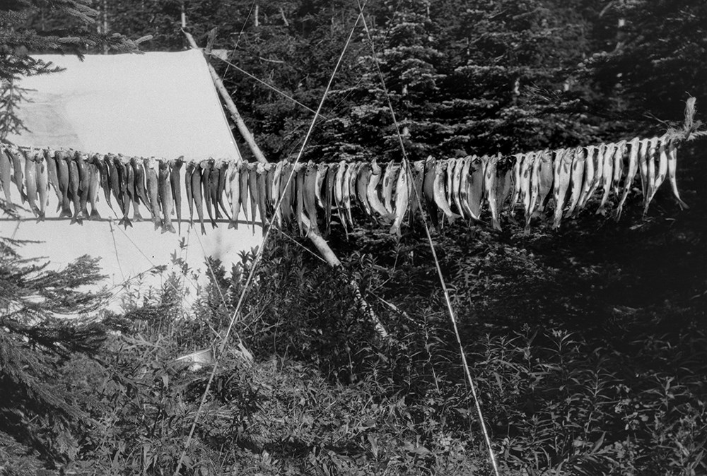
- File consists of 390 b&w negatives. The negatives pertain to Mount Chapman and Mount Custer; hunters checking slopes; hunters posed with a goat trophy; an unidentified man posed on slope of Belleview Hill; people on horses on Continental Divide North of Sage Pass; Cache Creek Falls; riders on a day…
- Date Range
- [ca.1904 to ca.1959]
- Reference Code
- V26 / IX / H / NA (H1-1) to V26 / IX / J / NA (J5-9)
- Description Level
- 5 / File
- GMD
- Photograph
- Negative
6 images
- Part Of
- Bert Riggall fonds
- Description Level
- 5 / File
- Fonds Number
- M376 / V26
- Series
- IX. Riggall Negatives Scanned and Described
- Sous-Fonds
- V26
- Accession Number
- 7102
- Reference Code
- V26 / IX / H / NA (H1-1) to V26 / IX / J / NA (J5-9)
- GMD
- Photograph
- Negative
- Date Range
- [ca.1904 to ca.1959]
- Physical Description
- 390 photographs :b&w negatives
- Scope & Content
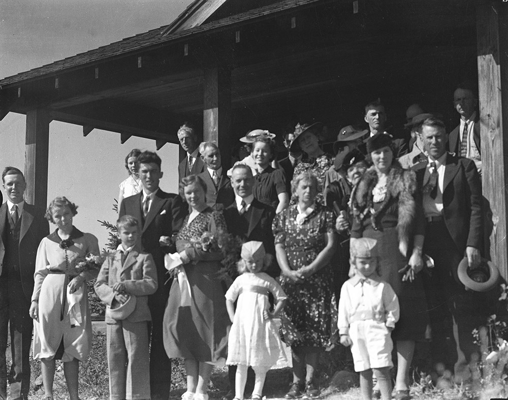
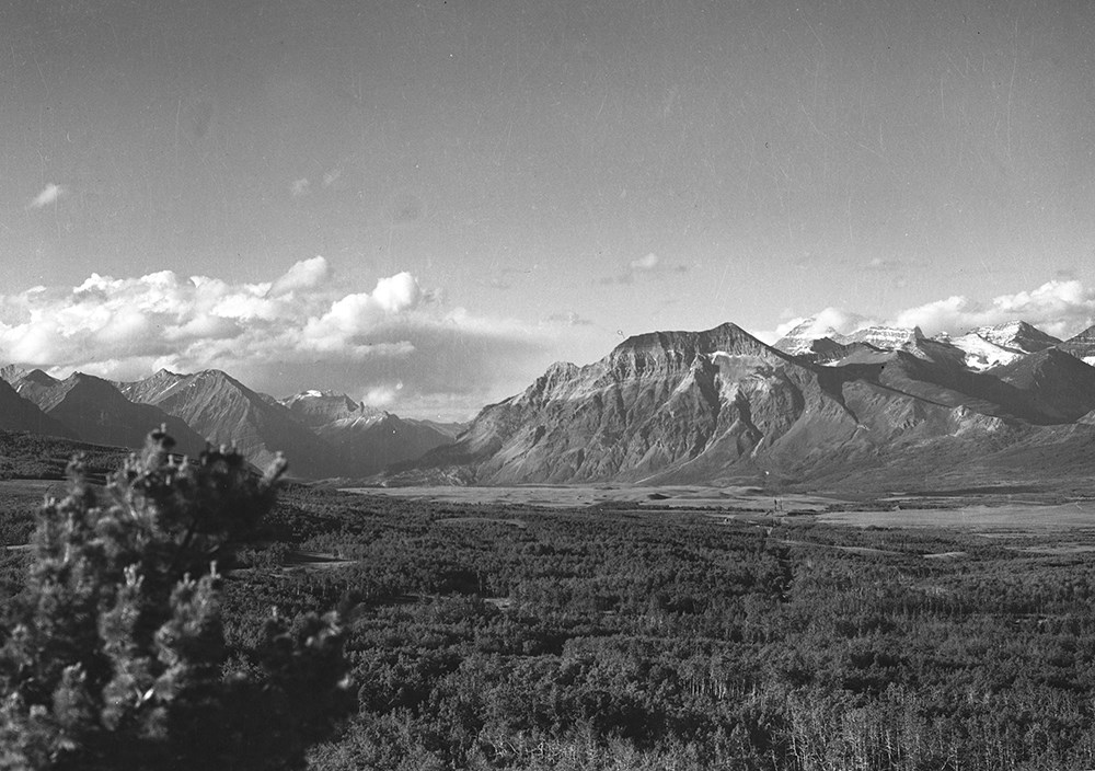
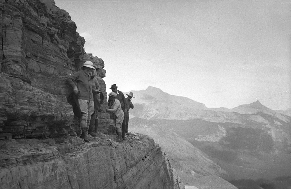
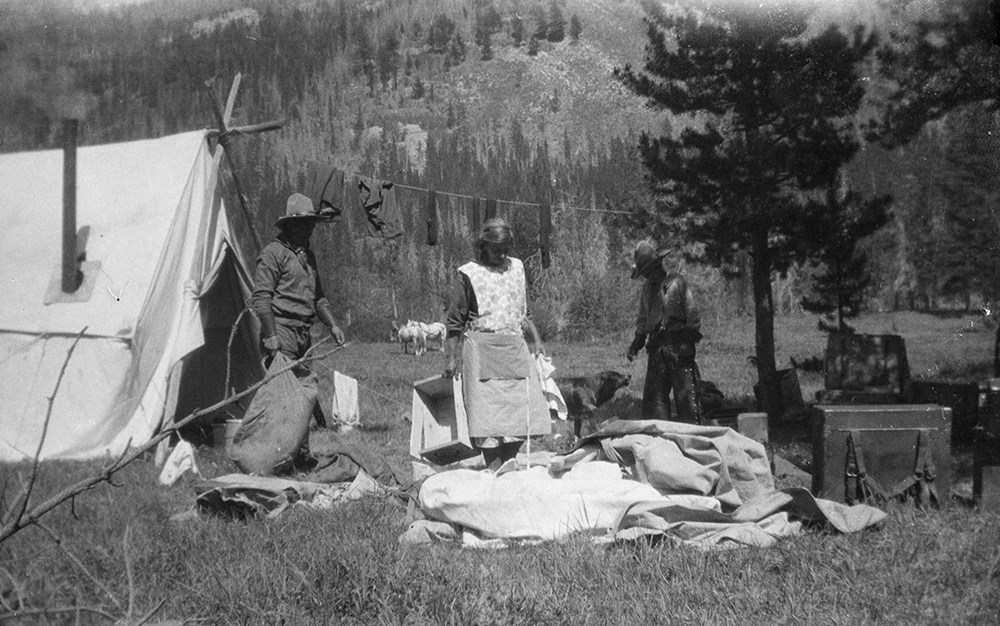
- File consists of 390 b&w negatives. The negatives pertain to Mount Chapman and Mount Custer; hunters checking slopes; hunters posed with a goat trophy; an unidentified man posed on slope of Belleview Hill; people on horses on Continental Divide North of Sage Pass; Cache Creek Falls; riders on a day trip; a camp scene of bedding being aired out; Mount Blackiston and Ruby Creek; the Beehive from Panorama Peak; various hunters; a red squirrel; fisherman, horses and tent at Crandell Lake; a mule deer on prairie part of Waterton Lakes National Park; two mule deer on slopes above Cameron Lake; woman on shore of Wall Lake; camp at Oyster Creek; Canadian two cent stamp; horses on ranch; hunters on vertical cliff; Summit Lake early in summer Mount Chapman; people and horses across from Beehive; two hunters in camp with deer trophy; packtrain below Broken Castle; Anderson Peak; mule deer buck; big horn ram on grassy slope; rams on a cliff; people on shore of Upper Kintla Lake, Long Knife Peak; rider at Oyster Creek camp; snow-covered camp scene; beaver dams and ponds on Dungarvin Creek; fisherman with large trout; McIntyre ranch buildings from Milk River Ridge; various camp scenes; Hawk's Nest cottage yard with trip supplies; packtrain wading up a river; packtrain in a meadow in the Oldman area; chicadee; gray-crowned rosy finches; downy woodpecker; columbia ground squirell; osprey nest near Oldman River; fisherman on Oldman River; A.O. Wheeler's mapping survey expeditions rock cairn; group on Tornado Pass; two people on Limestone Peak; Andy Russell and Jim Bennett on Tornado Mountain; andy Russell on top of cliff; Castle River rodeo; Sumner Crosby with a ram; lunch time on trip; Andy Russell field dressing a bull elk; guests on Mount Chimney; hunter on avalanche track; tents in snow; Lake Wurderman, Lake Nooney, and Mount Chapman; children eating on porch of Hawk's Nest; moving camp at Oyster Creek; limestone outcrop on corner of Lakeview Ridge; guest eatng at table in front of tent; Bert's car near Red Rock Canyon; saddle horses above South Kootenay Pass, Starvation Peak and King Edward; Mount Farquhar, Holcroft Mountain, Mount Scrimger; Jim Bennett with his movie camera near Beehive; Andy Russell and packtrain Oldman River valley; Lundbreck, Alberta; Pincher Creek and Castle Mountain; Upper Waterton Lake from Crandell; Andy and Kay Russell Wedding, 1938; Andy Russell snowshoeing; F.H.R's tipi; fishing at Wall Lake; Riggall's second Cottonwood Canyon house; Twin Lakes Camp; Kintla Lookout; Harwood Wedding.
- Subject Access
- Portraits
- Landscapes
- Hunting
- Guiding
- Pack trips
- Sports
- Recreation
- Wildlife
- Environment
- Snowshoes and snowshoeing
- Fishing
- Travel
- Geographic Access
- Canada
- Alberta
- Pincher Creek
- Canadian Rocky Mountains
- Waterton Lakes National Park
- Waterton
- Castle Mountain
- Language
- English
- Category
- Environment
- Exploration, discovery and travel
- Family and personal life
- Sports, recreation and leisure
- Title Source
- Title based on contents of file
- Content Details
- Reference scans available: V26 / IX / H / PA (H1) to V26 / IX / J / PA (J5)
- Processing Status
- Processed
Images

This material is presented as originally created; it may contain outdated cultural descriptions and
potentially offensive content.
Read more.
Travel guides - Waterton Lakes
https://archives.whyte.org/en/permalink/descriptions55918
- Part Of
- Ben Gadd fonds
- Scope & Content
- File consists of travel guides collected by Ben Gadd pertaining to Waterton Lakes National Park.
- Date Range
- [ca.1995-2000]
- Reference Code
- M590 / I / A / i / 8
- Description Level
- 5 / File
- GMD
- Published record
- Textual record
- Map
- Part Of
- Ben Gadd fonds
- Description Level
- 5 / File
- Fonds Number
- M590
- V810
- S61
- Series
- M590 / I : Personal records
- Sous-Fonds
- M590
- Sub-Series
- M590 / I / A : Travel guides and maps
- Accession Number
- 2021.20
- Reference Code
- M590 / I / A / i / 8
- Date Range
- [ca.1995-2000]
- Physical Description
- 1.5 cm of textual records
- Scope & Content
- File consists of travel guides collected by Ben Gadd pertaining to Waterton Lakes National Park.
- Notes
- One guide includes annotations on cover by Ben Gadd.
- Subject Access
- Geography
- Travel
- Tourism
- Tourist information
- Geographic Access
- Canada
- Alberta
- Waterton
- Waterton Lakes National Park
- Reproduction Restrictions
- Copyright restrictions may apply
- Language
- English
- Category
- Exploration, discovery and travel
- Title Source
- Title based on contents of file
- Processing Status
- Processed
This material is presented as originally created; it may contain outdated cultural descriptions and
potentially offensive content.
Read more.
Travel guides and maps
https://archives.whyte.org/en/permalink/descriptions56361
- Part Of
- Ben Gadd fonds
- Scope & Content
- Sub-series consists of travel brochures and maps which were collected and used by Ben Gadd. Sub-series contains five sub-sub series: M590 / I / A / i : Travel guides and pocket maps M590 / I / A / ii : Topographical maps M590 / I / A / iii : Geological maps M590 / I / A / iv : Highway maps M590 / …
- Date Range
- [ca.1920-2010]
- Reference Code
- M590 / I / A
- Description Level
- 4 / Sub-series
- GMD
- Map
- Textual record
- Part Of
- Ben Gadd fonds
- Description Level
- 4 / Sub-series
- Fonds Number
- M590
- V810
- S61
- Series
- M590 / I : Personal records
- Sous-Fonds
- M590
- Sub-Series
- M590 / I / A : Travel guides and maps
- Accession Number
- 2021.20
- Reference Code
- M590 / I / A
- GMD
- Map
- Textual record
- Date Range
- [ca.1920-2010]
- Physical Description
- ca. 274 maps -- ca. 61 travel guides, brochures
- Scope & Content
- Sub-series consists of travel brochures and maps which were collected and used by Ben Gadd. Sub-series contains five sub-sub series: M590 / I / A / i : Travel guides and pocket maps M590 / I / A / ii : Topographical maps M590 / I / A / iii : Geological maps M590 / I / A / iv : Highway maps M590 / I / A / v : Index maps, other
- Notes
- Some materials in sub-series are annotated with notes by Ben Gadd
- Name Access
- Gadd, Ben
- Subject Access
- Geography
- Geology
- Environment
- Map
- Tourism
- Tourist information
- Travel
- Trails
- Roads
- Transportation
- Natural history
- National parks and reserves
- Provincial parks and reserves
- Government
- Sports
- Recreation
- Hiking
- Geographic Access
- Canada
- Alberta
- British Columbia
- Banff National Park
- Jasper National Park
- Kootenay National Park
- Yoho National Park
- Waterton Lakes National Park
- Columbia Icefields
- United States of America
- Colorado
- Montana
- Yellowstone National Park
- Access Restrictions
- Restrictions may apply - some materials are fragile
- Reproduction Restrictions
- Restrictions may apply
- Language
- English
- Conservation
- Some fragile/torn materials stored in mylar
- Category
- Environment
- Exploration, discovery and travel
- Government
- Sports, recreation and leisure
- Transportation
- Tourism
- Title Source
- Title based on contents of sub-series
- Processing Status
- Processed
This material is presented as originally created; it may contain outdated cultural descriptions and
potentially offensive content.
Read more.