Narrow Results By
- Luxton family fonds 38
- Murray Hay fonds 17
- Ben Gadd fonds 15
- Chic Scott fonds 13
- Dorothy Wardle fonds 13
- Malcolm Geddes fonds 10
- Bert Riggall fonds 6
- Jean A. Hembroff MacDonald fonds 6
- Trail Riders of the Canadian Rockies fonds 5
- Percival R Lockie fonds 2
- Archives General File Collection 1
- Charles Reid fonds 1
1964 ski trip, skiing with friends
https://archives.whyte.org/en/permalink/descriptions55310
- Part Of
- Chic Scott fonds
- Scope & Content
- File consists of photographs pertaining to Hans Gmoser skiing with friends. Most photographs are from a 1964 ski trip between Toby Creek and the Bugaboos mountain range in British Columbia.
- Date Range
- 1964
- [1980 - 1990]
- Reference Code
- V40 / V / PA - 1 to 24
- Description Level
- 5 / File
- Part Of
- Chic Scott fonds
- Description Level
- 5 / File
- Fonds Number
- M57
- S47
- V40
- Series
- V40 / V : Deep Powder and Steep Rock
- Sous-Fonds
- V40
- Accession Number
- 2015.8559
- Reference Code
- V40 / V / PA - 1 to 24
- Date Range
- 1964
- [1980 - 1990]
- Physical Description
- 24 photographs : b&w and col. prints; 25 x 20 cm or smaller
- Scope & Content
- File consists of photographs pertaining to Hans Gmoser skiing with friends. Most photographs are from a 1964 ski trip between Toby Creek and the Bugaboos mountain range in British Columbia.
- Notes
- Photographs in file are accompanied by one page of handwritten notes pertaining to details of images from 1964 ski trip [PA - 1 to 21] and one copy of an Eaton's newspaper ad featuring an illustration of a ski jumper
- Name Access
- Gmoser, Hans
- McConkey, Jim
- Wiegele, Mike
- Grillmair, Leo
- Gertsch, Rudy
- Gmoser, Margaret
- Lemire, Pierre
- Subject Access
- Sports
- Recreation
- Skiing
- Ski jumping
- Mountains
- Landscapes
- Family and personal life
- Exploration
- Travel
- Winter
- Winter sports
- Geographic Access
- Canada
- British Columbia
- Toby Creek
- Bugaboos
- Canadian Rocky Mountains
- Reproduction Restrictions
- Restrictions may apply
- Language
- English
- Title Source
- Title based on contents of file
- Processing Status
- Processed
This material is presented as originally created; it may contain outdated cultural descriptions and
potentially offensive content.
Read more.
Abbot Pass and Mount Geikie ascent
https://archives.whyte.org/en/permalink/descriptions55238
- Part Of
- Malcolm Geddes fonds
- Scope & Content
- File consists of 5 b&w photographs pertaining to the 1924 ascent of Mount Geikie and a hike through Abbot Pass. Includes group images of Malcolm Geddes, Harry Pollard, T.B. Moffat, Alvin Geddes, and various unidentified members of the Alpine Club of Canada.
- Date Range
- [1922 - 1927]
- 1924
- Reference Code
- V756 / III / A / PA - 20 to 24
- Description Level
- 5 / File
- GMD
- Photograph
- Photograph print
- Part Of
- Malcolm Geddes fonds
- Description Level
- 5 / File
- Fonds Number
- M39
- V756
- Series
- V756 / III : Personal and family records
- Sous-Fonds
- V756
- Sub-Series
- V756 / III / A : Travel and mountain expeditions
- Accession Number
- 2015.8558
- Reference Code
- V756 / III / A / PA - 20 to 24
- Date Range
- [1922 - 1927]
- 1924
- Physical Description
- 5 photographs : b&w prints ; 18 x 24 cm or smaller
- Scope & Content
- File consists of 5 b&w photographs pertaining to the 1924 ascent of Mount Geikie and a hike through Abbot Pass. Includes group images of Malcolm Geddes, Harry Pollard, T.B. Moffat, Alvin Geddes, and various unidentified members of the Alpine Club of Canada.
- Notes
- Items are annotated on back
- Material Details
- One print is attached to a partial sheet of graph paper
- Name Access
- Geddes, Malcolm
- Pollard, Harry
- Moffat, Thomas B.
- Geddes, Alvin
- Subject Access
- Climbing
- Exploration
- Hiking
- Mountaineering
- Mountains
- Recreation
- Sports
- Summit
- Geographic Access
- Canada
- Alberta
- Abbot Pass
- British Columbia
- Mount Geikie
- Reproduction Restrictions
- Restrictions may apply
- Language
- English
- Conservation
- Items are stored in mylar
- Title Source
- Title based on contents of file
- Processing Status
- Processed
This material is presented as originally created; it may contain outdated cultural descriptions and
potentially offensive content.
Read more.
Author's copy of Geology Road Tours
https://archives.whyte.org/en/permalink/descriptions56293
- Part Of
- Ben Gadd fonds
- Scope & Content
- File consists of one author's copy of Ben Gadd's book, Geology Road Tours, which includes corrections and other annotations by the author.
- Date Range
- 2008
- Reference Code
- M590 / II / B / 59
- Description Level
- 5 / File
- GMD
- Textual record
- Published record
- Part Of
- Ben Gadd fonds
- Description Level
- 5 / File
- Fonds Number
- M590
- V810
- S61
- Series
- M590 / II : Research and publication records
- Sous-Fonds
- M590
- Sub-Series
- M590 / II / B : Other publications
- Accession Number
- 2021.20
- Reference Code
- M590 / II / B / 59
- Responsibility
- Produced by Ben Gadd, Corax Press
- Date Range
- 2008
- Physical Description
- 3.5 cm of textual records : 1 volume ; 15.5 x 23 cm
- Scope & Content
- File consists of one author's copy of Ben Gadd's book, Geology Road Tours, which includes corrections and other annotations by the author.
- Name Access
- Gadd, Ben
- Subject Access
- Publication
- Commercial products
- Environment
- Geology
- Science and technology
- Geography
- Natural history
- Travel
- Roads
- Map
- Geographic Access
- Canada
- Alberta
- British Columbia
- Canadian Rocky Mountains
- Reproduction Restrictions
- Copyright restrictions may apply
- Language
- English
- Title Source
- Title based on contents of file
- Processing Status
- Processed
This material is presented as originally created; it may contain outdated cultural descriptions and
potentially offensive content.
Read more.
Ballard family, England, Western Canada and United States travel photographs
https://archives.whyte.org/en/permalink/descriptions54976
- Part Of
- Luxton family fonds
- Scope & Content
- File consists of photographs and postcard prints pertaining to the Ballard family and their travels within England, Western Canada and the United States. Includes images of Jack Ballard[?] and children Sidney and Shirley Ballard; Stonehenge; transport and telegraph stations; foot bridges, hiking, c…
- Date Range
- 1903
- 1907-1909
- [1910-1915]
- [1920-1924]
- Reference Code
- LUX / I / E4 / PA - 173 to 201
- Description Level
- 5 / File
- GMD
- Photograph
- Photograph print
- Part Of
- Luxton family fonds
- Description Level
- 5 / File
- Fonds Number
- LUX
- Series
- LUX / I / E : Collected material
- Sous-Fonds
- LUX / I : Norman Luxton sous-fonds
- Sub-Series
- LUX / I / E4 : Photographs
- Accession Number
- LUX
- Reference Code
- LUX / I / E4 / PA - 173 to 201
- Date Range
- 1903
- 1907-1909
- [1910-1915]
- [1920-1924]
- Physical Description
- 29 photographs : b&w prints ; 16.5 x 10.5 cm or smaller
- Scope & Content
- File consists of photographs and postcard prints pertaining to the Ballard family and their travels within England, Western Canada and the United States. Includes images of Jack Ballard[?] and children Sidney and Shirley Ballard; Stonehenge; transport and telegraph stations; foot bridges, hiking, canoeing and camping scenes; and the Totem Cafe in Montana. Locations include: New Iskoot, Aiyanish[?], Echo Lake, 25 Mile Cabin, Yellowstone [Montana], Iron River, and Idaho.
- Notes
- Some items are dated and/or contain personal letters written on the back.
- Name Access
- Ballard, Sidney
- Ballard, Shirley
- Ballard, Jack
- Subject Access
- Travel
- Hiking
- Hunting
- Wildlife
- Family and personal life
- Canoes and canoeing
- Boats
- Transportation
- Businesses
- Children
- Cabins
- Landscapes
- Land, settlement and immigration
- Land use
- Geographic Access
- Canada
- Alberta
- British Columbia
- Echo Lake
- United States of America
- New York
- Montana
- Yellowstone
- Idaho
- Wisconsin
- Language
- English
- Conservation
- Items stored in mylar
- Title Source
- Title based on contents of file
- Processing Status
- Processed
This material is presented as originally created; it may contain outdated cultural descriptions and
potentially offensive content.
Read more.
Banff and area businesses, townsite, scenic views
https://archives.whyte.org/en/permalink/descriptions55024
- Part Of
- Luxton family fonds
- Scope & Content
- File consists of photographs pertaining to businesses, tourist attractions and natural views in and around Banff. Includes images of backcountry camps in Banff National Park; the Bow River Boat House; Beaver Lodge and Bampton Cottage [both located on Beaver Street in Banff]; fires at Breton Hall Ho…
- Date Range
- [ca.1890-1900]
- [1896-1898]
- 1904-1905
- [ca.1910-1920]
- 1912
- 1914
- [ca.1930-1935]
- 1933
- 1941
- [ca.1950-1960]
- Reference Code
- LUX / I / D6c / PA - 133 to 182
- Description Level
- 5 / File
- GMD
- Photograph
- Photograph print
1 image
- Part Of
- Luxton family fonds
- Description Level
- 5 / File
- Fonds Number
- LUX
- Series
- LUX / I / D : Professional and Personal
- Sous-Fonds
- LUX / I : Norman Luxton sous-fonds
- Sub-Series
- LUX / I / D6 : Other activities and interests
- Accession Number
- LUX
- Reference Code
- LUX / I / D6c / PA - 133 to 182
- Responsibility
- PA-182 produced by Canadian Pacific
- Date Range
- [ca.1890-1900]
- [1896-1898]
- 1904-1905
- [ca.1910-1920]
- 1912
- 1914
- [ca.1930-1935]
- 1933
- 1941
- [ca.1950-1960]
- Physical Description
- 50 photographs ; b&w prints ; 25 x 20.5 cm or smaller
- Scope & Content
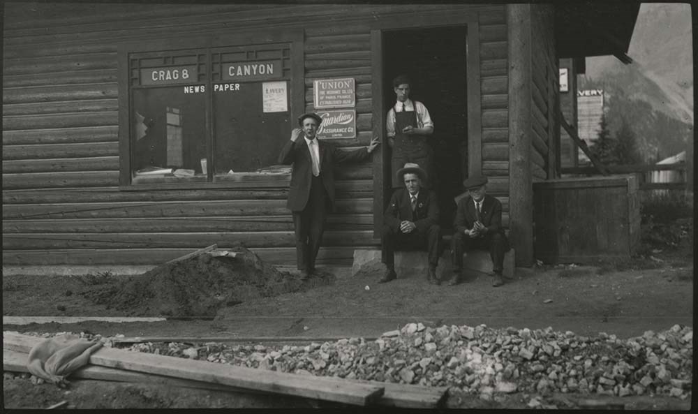
- File consists of photographs pertaining to businesses, tourist attractions and natural views in and around Banff. Includes images of backcountry camps in Banff National Park; the Bow River Boat House; Beaver Lodge and Bampton Cottage [both located on Beaver Street in Banff]; fires at Breton Hall Hotel and Banff Springs Hotel; the Park Museum and Information Bureau; early views of Banff Springs Hotel [1904]; Vermillion River Bungalow Camp and the Lake Louise Chalet; Paddy J. Nolan’s home [built by Norman Luxton]; a postcard print titled “Starved Bachelors Retreat Banff Alberta"; swimming at the Cave and Basin[?] and Banff Upper Hot Springs; the Crag and Canyon office [ca.1905]; Skoki Lodge; and the office of photographers Wilson and Fear [1896-1898].
- Notes
- Photographs LUX/I/D6c/PA-181 and 182 [depicting Wilson and Fear storefront] are copies of the same image but annotated with different dates [ca.1896 and ca.1898]. Based on context and dating of related images in Whyte Museum archives, actual image date may be closer to [ca.1894].
- Material Details
- LUX/I/D6c/PA-173 has three red sun-shaped stickers attached to back left corner, red ribbon attached to back right corner
- Name Access
- Wilson, John
- Fear, George
- Fear, William (Bill)
- Nolan, Paddy J.
- Luxton, Norman
- Smyth, S. A.
- Subject Access
- Bow River Boat House
- Pack trips
- Horses
- Teepees
- Boats
- Property
- Land use
- Hotels
- Fire
- Banff Springs Hotel
- Photography
- Businesses
- Tourism
- Hot Springs
- Leisure
- Mountain
- Newspaper
- Organizations
- Travel
- Geographic Access
- Canada
- Alberta
- Banff
- Banff National Park
- Vermilion Lakes
- Lake Louise
- Bow River
- Sulphur Mountain
- Cave and Basin
- Language
- English
- Related Material
- Items LUX/I/D6c/PA-163 to 168 have duplicate negative copies processed as LUX/I/D6c/NA-41 to 46
- Title Source
- Title based on contents of file
- Processing Status
- Processed
Images
This material is presented as originally created; it may contain outdated cultural descriptions and
potentially offensive content.
Read more.
Banff National Park and Lake Louise maps
https://archives.whyte.org/en/permalink/descriptions54945
- Scope & Content
- File consists of two folded maps and a small clipping [possibly top or bottom portion from a different map or one of maps in file]. One map is of Banff National Park and one is of Lake Louise [1959]. Banff National Park map has black pencil tracings over trail section near the bottom of the map and…
- Date Range
- 1959
- [1960-1970]
- Reference Code
- M545 / V / 53
- Description Level
- 5 / File
- GMD
- Textual record
- Published record
- Map
- Description Level
- 5 / File
- Fonds Number
- M545 / V635
- Series
- M545 / V : Administrative records
- Sous-Fonds
- M545
- Accession Number
- 8235
- Reference Code
- M545 / V / 53
- Date Range
- 1959
- [1960-1970]
- Physical Description
- 0.5 cm of textual records (2 maps ; 60.5 x 57.5 and 60 x 56.5 cm)
- Scope & Content
- File consists of two folded maps and a small clipping [possibly top or bottom portion from a different map or one of maps in file]. One map is of Banff National Park and one is of Lake Louise [1959]. Banff National Park map has black pencil tracings over trail section near the bottom of the map and annotation in bottom right corner which reads "Natural Bridge". Lake Louise map produced by the Government of Canada.
- Subject Access
- Banff National Park
- Environment
- Geography
- Map
- Lake Louise
- Travel
- Government
- National parks and reserves
- Trails
- Geographic Access
- Canada
- Alberta
- Banff National Park
- Lake Louise
- Language
- English
- Conservation
- Clipping stored in mylar due to significant staining and residue from tape
- Items kept folded [not placed in mylar] due to mass production of content and minimal/no annotations
- Title Source
- Title based on contents of file
- Processing Status
- Processed
This material is presented as originally created; it may contain outdated cultural descriptions and
potentially offensive content.
Read more.
Banff National Park (general)
https://archives.whyte.org/en/permalink/descriptions55338
- Part Of
- Murray Hay fonds
- Scope & Content
- File consists of 4 prings : col. 35.1 x 24.8 cm or smaller and 4 maps (2 paper, 2 overlays) : col., on mylar ; 60.4 x 30. cm or smaller. File pertains to aerial views of Banff National Park, showing the towns of Banff and Lake Louise, ski hills (Norqay Ski Hill, Sunshine Village, and Lake Louise Sk…
- Date Range
- ca.1976-ca.2000
- Reference Code
- V795 / II / B / v / 1-2
- Description Level
- 5 / File
- GMD
- Map
- Private record
- Part Of
- Murray Hay fonds
- Description Level
- 5 / File
- Fonds Number
- M570 / V795
- Series
- V795 / II : Unpublished Material
- Sous-Fonds
- V795
- Sub-Series
- V795 / II / B : Alberta / v : Banff National Park
- Accession Number
- 2019.41
- Reference Code
- V795 / II / B / v / 1-2
- GMD
- Map
- Private record
- Date Range
- ca.1976-ca.2000
- Physical Description
- 4 prints : col. 35.1 x 24.8 cm or smaller
- 4 maps (2 paper, 2 overlays) : col., annotations, on mylar ; 60.4 x 30. cm or smaller
- Scope & Content
- File consists of 4 prings : col. 35.1 x 24.8 cm or smaller and 4 maps (2 paper, 2 overlays) : col., on mylar ; 60.4 x 30. cm or smaller. File pertains to aerial views of Banff National Park, showing the towns of Banff and Lake Louise, ski hills (Norqay Ski Hill, Sunshine Village, and Lake Louise Ski Resort), as well as other georgraphic features. The mylar overlays contain various amounts of detail and annotations - one consists of a dark red sheet overlayed with place names in negative.
- Notes
- Items not in oversize stored in downstairs vault.
- Name Access
- Hay, Murray
- Subject Access
- Advertising
- Artist
- Ski Maps
- Map
- Cartography
- Sports and recreation
- Tourism
- Tourist information
- Winter
- Winter sports
- Ski area
- Sunshine Village
- Norquay Ski Hill
- Lake Louise Ski Area
- Geographic Access
- Banff
- Lake Louise
- Banff National Park
- Alberta
- Canada
- Canadian Rocky Mountains
- Language
- English
- Creator
- Hay, Murray
- Title Source
- Title based on contents of file
- Processing Status
- Processed
This material is presented as originally created; it may contain outdated cultural descriptions and
potentially offensive content.
Read more.
[Banff Visit Scrapbook]
https://archives.whyte.org/en/permalink/descriptions54911
- Part Of
- Stewart family fonds
- Scope & Content
- File consists of a scrapbook containing newspaper accounts by travellers in the Rockies and Selkirks, particularly descriptions of Banff town, Banff Springs Hotel, the hot springs and vicinity. The Stewarts are frequently mentioned, having extended their hospitality to the various writers. The al…
- Date Range
- [ca.1880]-1894
- Reference Code
- M104 / 1
- Description Level
- 5 / File
- GMD
- Scrapbook
1 image
1 Electronic Resource
- Part Of
- Stewart family fonds
- Description Level
- 5 / File
- Fonds Number
- M104 / V209
- Sous-Fonds
- M104
- Accession Number
- 729
- Reference Code
- M104 / 1
- GMD
- Scrapbook
- Date Range
- [ca.1880]-1894
- Physical Description
- 2cm of textual records (18 pages ; 21.5 x 35 cm)
- History / Biographical
- George A. Stewart, 1830-1917, was the first Superintendent of Rocky Mountains Park (now Banff National Park) from 1886-1897. George and Frances Stewart, 1843-1932, and family were prominent early residents of Banff.
- Scope & Content
- File consists of a scrapbook containing newspaper accounts by travellers in the Rockies and Selkirks, particularly descriptions of Banff town, Banff Springs Hotel, the hot springs and vicinity. The Stewarts are frequently mentioned, having extended their hospitality to the various writers. The album has been autographed at a later date by Olive Stewart Foster.
- Name Access
- Stewart, George A.
- Subject Access
- Exploration, discovery and travel
- Family and personal life
- Geographic Access
- Banff
- Lake Louise
- Banff National Park
- Alberta
- Canada
- Access Restrictions
- No restrictions on access
- Copyright, privacy, commercial use and other restrictions may apply
- Language
- English
- Conservation
- Blank pages not scanned
- Creator
- Stewart, George A.
- Title Source
- Title based on contents of file
- Processing Status
- Processed
Electronic Resources
Images
This material is presented as originally created; it may contain outdated cultural descriptions and
potentially offensive content.
Read more.
Bennett Trips 1931 to 1936
https://archives.whyte.org/en/permalink/descriptions23415
- Part Of
- Bert Riggall fonds
- Scope & Content
- File consists of 22 b&w photographs, some captioned. Photographs pertain to the Bennett trips guided and outfitted by Riggall of 1931, 1933, 1934, 1935, and 1936. The photographs document packtrains, camp life, hiking, Herbst glacier, and fishing. Locations of photographs include: Wall Lake, Mount …
- Date Range
- 1931
- 1933-1936
- Reference Code
- V26 / II / A4 / PA - 130 to 152
- Description Level
- 5 / File
- GMD
- Photograph
- Photograph print
- Part Of
- Bert Riggall fonds
- Description Level
- 5 / File
- Fonds Number
- M376 / V26
- Series
- II.Business and Financial: Client Papers and Photographs
- Sous-Fonds
- V26
- Accession Number
- 7201
- Reference Code
- V26 / II / A4 / PA - 130 to 152
- Date Range
- 1931
- 1933-1936
- Physical Description
- Photographs: 22 b&w prints
- Scope & Content
- File consists of 22 b&w photographs, some captioned. Photographs pertain to the Bennett trips guided and outfitted by Riggall of 1931, 1933, 1934, 1935, and 1936. The photographs document packtrains, camp life, hiking, Herbst glacier, and fishing. Locations of photographs include: Wall Lake, Mount Festubert, Great Divide at South Kootenay Pass.
- Subject Access
- Guiding, Camping, Packtrains
- Hiking
- Camping
- Recreation
- Sports
- Fishing
- Geographic Access
- Canada
- Canadian Rocky Mountains
- British Columbia
- Kootenay National Park
- Great Divide
- Language
- N/A
- Title Source
- Title based on contents of file
- Processing Status
- Processed
This material is presented as originally created; it may contain outdated cultural descriptions and
potentially offensive content.
Read more.
Bert Riggall's 1000 Mile Pack trip
https://archives.whyte.org/en/permalink/descriptions23454
- Part Of
- Bert Riggall fonds
- Scope & Content
- File consists of 43 b&w photographs, some captioned. Photographs pertain to Riggall's 1911 1000 mile pack trip undertaken to seek out areas for hunting and outfitting following the enlargement of Waterton National Park and the reduction of available hunting area for Riggall's clients. The prints do…
- Date Range
- 1911
- Reference Code
- V26 / II / A7 / PA - 119 to 161
- Description Level
- 5 / File
- GMD
- Photograph
- Photograph print
1 image
- Part Of
- Bert Riggall fonds
- Description Level
- 5 / File
- Fonds Number
- M376 / V26
- Series
- II.Business and Financial: Bert Riggall's 1000 Mile Pack trip, 1911
- Sous-Fonds
- V26
- Accession Number
- 7201
- Reference Code
- V26 / II / A7 / PA - 119 to 161
- Date Range
- 1911
- Physical Description
- 43 photographs: b&w prints
- Scope & Content
- File consists of 43 b&w photographs, some captioned. Photographs pertain to Riggall's 1911 1000 mile pack trip undertaken to seek out areas for hunting and outfitting following the enlargement of Waterton National Park and the reduction of available hunting area for Riggall's clients. The prints document this pack trip from stops in Banff, AB and Cranbrook, BC, and the extent of his mountain exploration from Fort Steele to Edson. On this trip, approximately 150 miles of new trail was cut including portions of Roger's Pass.
- Subject Access
- Pack trips
- Exploration
- Trails
- Trail making
- Recreation
- Hunting
- Outfitters, trail guides and packers
- Geographic Access
- Canada
- Alberta
- Banff National Park
- Waterton National Park
- British Columbia
- Cranbrook
- Rogers Pass
- Language
- English
- Title Source
- Title based on contents of file
- Processing Status
- Processed
Images

This material is presented as originally created; it may contain outdated cultural descriptions and
potentially offensive content.
Read more.