Narrow Results By
Abbot Pass and Mount Geikie ascent
https://archives.whyte.org/en/permalink/descriptions55238
- Part Of
- Malcolm Geddes fonds
- Scope & Content
- File consists of 5 b&w photographs pertaining to the 1924 ascent of Mount Geikie and a hike through Abbot Pass. Includes group images of Malcolm Geddes, Harry Pollard, T.B. Moffat, Alvin Geddes, and various unidentified members of the Alpine Club of Canada.
- Date Range
- [1922 - 1927]
- 1924
- Reference Code
- V756 / III / A / PA - 20 to 24
- Description Level
- 5 / File
- GMD
- Photograph
- Photograph print
- Part Of
- Malcolm Geddes fonds
- Description Level
- 5 / File
- Fonds Number
- M39
- V756
- Series
- V756 / III : Personal and family records
- Sous-Fonds
- V756
- Sub-Series
- V756 / III / A : Travel and mountain expeditions
- Accession Number
- 2015.8558
- Reference Code
- V756 / III / A / PA - 20 to 24
- Date Range
- [1922 - 1927]
- 1924
- Physical Description
- 5 photographs : b&w prints ; 18 x 24 cm or smaller
- Scope & Content
- File consists of 5 b&w photographs pertaining to the 1924 ascent of Mount Geikie and a hike through Abbot Pass. Includes group images of Malcolm Geddes, Harry Pollard, T.B. Moffat, Alvin Geddes, and various unidentified members of the Alpine Club of Canada.
- Notes
- Items are annotated on back
- Material Details
- One print is attached to a partial sheet of graph paper
- Name Access
- Geddes, Malcolm
- Pollard, Harry
- Moffat, Thomas B.
- Geddes, Alvin
- Subject Access
- Climbing
- Exploration
- Hiking
- Mountaineering
- Mountains
- Recreation
- Sports
- Summit
- Geographic Access
- Canada
- Alberta
- Abbot Pass
- British Columbia
- Mount Geikie
- Reproduction Restrictions
- Restrictions may apply
- Language
- English
- Conservation
- Items are stored in mylar
- Title Source
- Title based on contents of file
- Processing Status
- Processed
This material is presented as originally created; it may contain outdated cultural descriptions and
potentially offensive content.
Read more.
Big White Ski Village
https://archives.whyte.org/en/permalink/descriptions54801
- Part Of
- Murray Hay fonds
- Scope & Content
- File consists of 0.5 cm of textual records, 90 x 60.5 cm. File pertains to ski trail maps of Big White Ski Village and Area created by Murray Hay. File includes one oversized published reproduction of a Big White trail map in poster format.
- Date Range
- ca.1980 - ca.2000
- Reference Code
- M570 / III / A / v / 1
- Description Level
- 5 / File
- GMD
- Map
- Poster
- Published record
- Textual record
- Part Of
- Murray Hay fonds
- Description Level
- 5 / File
- Fonds Number
- M570 / V795
- Series
- M570 / III : Murray Hay portfolio (published material)
- Sous-Fonds
- M570
- Sub-Series
- M570 / III / A : British Columbia / v : Big White
- Accession Number
- 2019.41
- Reference Code
- M570 / III / A / v / 1
- Date Range
- ca.1980 - ca.2000
- Physical Description
- 0.5 cm of textual records (90 x 60.5 cm)
- Scope & Content
- File consists of 0.5 cm of textual records, 90 x 60.5 cm. File pertains to ski trail maps of Big White Ski Village and Area created by Murray Hay. File includes one oversized published reproduction of a Big White trail map in poster format.
- Name Access
- Hay, Murray
- Subject Access
- Ski Maps
- Map
- Ski area
- Skiing
- Tourism
- Travel
- Winter
- Winter sports
- Sports and recreation
- Big White Ski Area
- Tourist information
- Artist
- Advertising
- Geographic Access
- Kelowna
- British Columbia
- Canada
- Language
- English
- Related Material
- V795 / II / A / iv / 5
- Title Source
- Title based on contents of file
- Processing Status
- Processed
This material is presented as originally created; it may contain outdated cultural descriptions and
potentially offensive content.
Read more.
Canadian Rockies
https://archives.whyte.org/en/permalink/descriptions54817
- Part Of
- Murray Hay fonds
- Scope & Content
- File consists of 1 cm of textual records, 10 x 22 cm. File pertains to tourist maps of the Canadian Rocky Mountains created by Murray Hay. File includes a brochure of titled "Canadian Rockies Access Maps" that, when unfolded, includes several maps of the various areas that make up the Canadian Rock…
- Date Range
- ca. 1990 - 1999
- 1999
- Reference Code
- M570 / III / D / i / 2
- Description Level
- 5 / File
- GMD
- Published record
- Map
- Textual record
- Part Of
- Murray Hay fonds
- Description Level
- 5 / File
- Fonds Number
- M570 / V795
- Series
- M570 / III : Murray Hay portfolio (published material)
- Sous-Fonds
- M570
- Sub-Series
- M570 / III / D : Miscellaneous / i : Canada (general)
- Accession Number
- 2019.41
- Reference Code
- M570 / III / D / i / 2
- Date Range
- ca. 1990 - 1999
- 1999
- Physical Description
- 1 cm of textual records (10 x 22 cm)
- Scope & Content
- File consists of 1 cm of textual records, 10 x 22 cm. File pertains to tourist maps of the Canadian Rocky Mountains created by Murray Hay. File includes a brochure of titled "Canadian Rockies Access Maps" that, when unfolded, includes several maps of the various areas that make up the Canadian Rocky Mountains, like Kananaskis Country, Canmore, Banff National Park, Jasper National Park, Yoho National Park, etc.
- Name Access
- Hay, Murray
- Subject Access
- Advertising
- Artist
- Banff
- Banff National Park
- Cartography
- Communications
- Lake Louise
- Kananaskis Country
- Map
- Mountains
- Tourism
- Tourist information
- Travel
- Geographic Access
- Canada
- Canadian Rocky Mountains
- Alberta
- British Columbia
- Yoho National Park
- Jasper National Park
- Banff National Park
- Glacier National Park
- Canmore
- Banff
- Jasper
- Lake Louise
- Kananaskis
- Kananaskis Country
- Kootenay National Park
- Language
- English
- Title Source
- Title based on contents of file
- Processing Status
- Processed
This material is presented as originally created; it may contain outdated cultural descriptions and
potentially offensive content.
Read more.
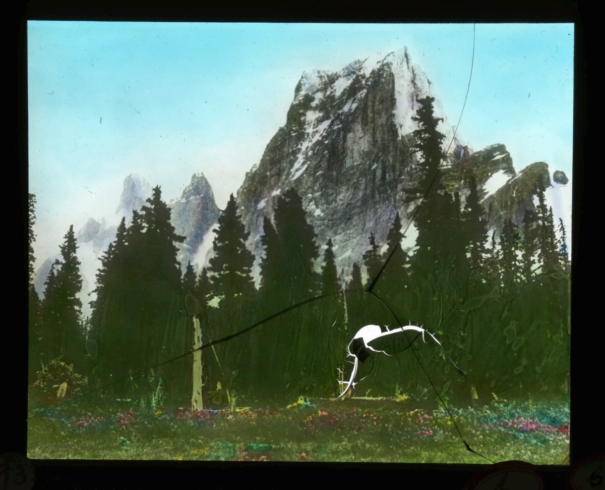
Canadian Rockies mountaineering trips, Alpine Club of Canada expeditions
https://archives.whyte.org/en/permalink/descriptions55242
- Part Of
- Malcolm Geddes fonds
- Scope & Content
- File consists of 129 lantern slides pertaining to mountaineering expeditions and scenic views in the Canadian Rockies. Includes images of pack trips, ice climbing, hiking, and Alpine Club of Canada camps. Locations include Emperor Falls; Berg Lake; ascent of Resplendent Mountain; Mount Edith Cavell…
- Date Range
- [1913-1925]
- Reference Code
- V756 / III / A / PS - 1 to 129
- Description Level
- 5 / File
- GMD
- Photograph
- Lantern slide
1 image
- Part Of
- Malcolm Geddes fonds
- Description Level
- 5 / File
- Fonds Number
- M39
- V756
- Series
- V756 / III : Personal and family records
- Sous-Fonds
- V756
- Sub-Series
- V756 / III / A : Travel and mountain expeditions
- Accession Number
- 6504
- Reference Code
- V756 / III / A / PS - 1 to 129
- Responsibility
- Some items produced by Charles Potter and James Mahon
- Date Range
- [1913-1925]
- Physical Description
- 129 photographs : lantern slides
- Scope & Content
- File consists of 129 lantern slides pertaining to mountaineering expeditions and scenic views in the Canadian Rockies. Includes images of pack trips, ice climbing, hiking, and Alpine Club of Canada camps. Locations include Emperor Falls; Berg Lake; ascent of Resplendent Mountain; Mount Edith Cavell; Mount Maud; Mount Commander; Mount Marpole; Mount Habel; Mount Robson; Mount Temple; Mount Huber; Castle Mountain; and Wilcox Pass.
- Notes
- Some items are numbered on outer edges or otherwise labelled
- Material Details
- Some items hand-coloured
- Name Access
- Gibbon, John Murray
- Wheeler, A. O. (Arthur Oliver)
- Geddes, Malcolm
- Alpine Club of Canada
- Subject Access
- Travel
- Exploration
- Hiking
- Ice climbing
- Summit
- Mountains
- Landscapes
- Recreation
- Alpine Club of Canada
- Glaciers
- Trails
- Pack trips
- Camping
- Geographic Access
- Canada
- Alberta
- British Columbia
- Canadian Rocky Mountains
- Mount Robson
- Mount Temple
- Mount Habel
- Mount Geikie
- Mount Huber
- Castle Mountain
- Wilcox Pass
- Mount Edith Cavell
- Mount Maud
- Mount Commander
- Mount Marpole
- Access Restrictions
- Fragile - restrictions may apply
- Reproduction Restrictions
- Fragile- restrictions may apply
- Language
- N/A
- Title Source
- Title based on contents of file
- Processing Status
- Processed
Images
This material is presented as originally created; it may contain outdated cultural descriptions and
potentially offensive content.
Read more.
Cariboo Monashee Heli-Skiing
https://archives.whyte.org/en/permalink/descriptions54812
- Part Of
- Murray Hay fonds
- Scope & Content
- File consists of 1 cm of textual records, 28 x 21.5 cm. File pertains to maps related to the ski areas utilized by Helicopter Skiing Canada in Cariboo Monashee Country, created by Murray Hay. File includes reproductions of the maps in an individual promotional map with information on the back and a…
- Date Range
- ca. 1978 - ca. 1979
- Reference Code
- M570 / III / A / vii / 1
- Description Level
- 5 / File
- GMD
- Map
- Published record
- Textual record
- Part Of
- Murray Hay fonds
- Description Level
- 5 / File
- Fonds Number
- M570 / V795
- Series
- M570 / III : Murray Hay portfolio (published material)
- Sous-Fonds
- M570
- Sub-Series
- M570 / III / A : British Columbia / vii : Cariboo Monashee
- Accession Number
- 2019.41
- Reference Code
- M570 / III / A / vii / 1
- Date Range
- ca. 1978 - ca. 1979
- Physical Description
- 1 cm of textual records (28 x 21.5 cm)
- Scope & Content
- File consists of 1 cm of textual records, 28 x 21.5 cm. File pertains to maps related to the ski areas utilized by Helicopter Skiing Canada in Cariboo Monashee Country, created by Murray Hay. File includes reproductions of the maps in an individual promotional map with information on the back and a bound brochure (which also includes the map) promoting helicopter skiing.
- Notes
- Dates are approximate based on the ages of the daughter of Mike Wiegele (owner of Cariboo Monashee Helicopter Skiing Canada), who was born in 1970 and is aged 8 in the photographs included in the booklet.
- Name Access
- Hay, Murray
- Subject Access
- Ski Maps
- Skiing
- Ski touring
- Ski areas
- Helicopter skiing
- Cartography
- Tourism
- Tourist information
- Sports and recreation
- Travel
- Winter
- Winter sports
- Advertising
- Artist
- Geographic Access
- British Columbia
- Canada
- Monashee Mountains
- Cariboo Mountains
- Language
- English
- Title Source
- Title based on contents of file
- Processing Status
- Processed
This material is presented as originally created; it may contain outdated cultural descriptions and
potentially offensive content.
Read more.
Drafts, edited copies
https://archives.whyte.org/en/permalink/descriptions55248
- Part Of
- Malcolm Geddes fonds
- Scope & Content
- File consists of handwritten and typed drafts of works by Malcolm Geddes. Content pertains to the first ascent of Mount Geikie, mountaineering and mountain climbing, and life in Western Canada and Parry Sound, Ontario. Includes three typed drafts of "Beyond the Eagle's Nest" with edits and correcti…
- Date Range
- [1890-1900]
- [1900-1920]
- [1925-1927]
- Reference Code
- M39 / I / B / 2
- Description Level
- 5 / File
- GMD
- Textual record
- Part Of
- Malcolm Geddes fonds
- Description Level
- 5 / File
- Fonds Number
- M39
- V756
- Series
- M39 / I : Professional records
- Sous-Fonds
- M39
- Sub-Series
- M39 / I / B : Manuscripts and drafts
- Accession Number
- 7846
- Reference Code
- M39 / I / B / 2
- GMD
- Textual record
- Date Range
- [1890-1900]
- [1900-1920]
- [1925-1927]
- Physical Description
- 2 cm of textual records
- Scope & Content
- File consists of handwritten and typed drafts of works by Malcolm Geddes. Content pertains to the first ascent of Mount Geikie, mountaineering and mountain climbing, and life in Western Canada and Parry Sound, Ontario. Includes three typed drafts of "Beyond the Eagle's Nest" with edits and corrections.
- Name Access
- Geddes, Malcolm
- Subject Access
- Mountains
- Mountaineering
- Exploration
- Travel
- Family and personal life
- Summit
- Settlement
- Geographic Access
- Canada
- British Columbia
- Mount Geikie
- Canadian Rocky Mountains
- Ontario
- Parry Sound
- Reproduction Restrictions
- Restrictions may apply
- Language
- English
- Category
- Exploration, discovery and travel
- Family and personal life
- Land, settlement and immigration
- Title Source
- Title based on contents of file
- Processing Status
- Processed
This material is presented as originally created; it may contain outdated cultural descriptions and
potentially offensive content.
Read more.
Fairmont Hot Springs
https://archives.whyte.org/en/permalink/descriptions54807
- Part Of
- Murray Hay fonds
- Scope & Content
- File consists of 1 cm of textual records, 23 x 30 cm. File pertains to alpine and cross-country ski trail maps at Fairmont Hot Springs created by Murray Hay. File includes a reproduced map of the resort village and ski areas that was included in a bound brochure promoting Vacation Lease Ownership a…
- Date Range
- ca. 1980 - ca. 1990
- Reference Code
- M570 / III / A / vi / 1
- Description Level
- 5 / File
- GMD
- Map
- Textual record
- Published record
- Part Of
- Murray Hay fonds
- Description Level
- 5 / File
- Fonds Number
- M570 / V795
- Series
- M570 / III : Murray Hay portfolio (published material)
- Sous-Fonds
- M570
- Sub-Series
- M570 / III / A : British Columbia / vi : Fairmont Hot Springs
- Accession Number
- 2019.41
- Reference Code
- M570 / III / A / vi / 1
- Date Range
- ca. 1980 - ca. 1990
- Physical Description
- 1 cm of textual records (23 x 30 cm)
- Scope & Content
- File consists of 1 cm of textual records, 23 x 30 cm. File pertains to alpine and cross-country ski trail maps at Fairmont Hot Springs created by Murray Hay. File includes a reproduced map of the resort village and ski areas that was included in a bound brochure promoting Vacation Lease Ownership at the Fairmont Hot Springs Villas.
- Name Access
- Hay, Murray
- Subject Access
- Cartography
- Map
- Ski Maps
- Skiing
- Ski area
- Hot Springs
- Resort
- Winter sports
- Tourism
- Tourist information
- Travel
- Advertising
- Artist
- Geographic Access
- British Columbia
- Canada
- Fairmont Hot Springs
- Language
- English
- Related Material
- V795 / II / A / viii / 1
- Title Source
- Title based on contents of file
- Processing Status
- Processed
This material is presented as originally created; it may contain outdated cultural descriptions and
potentially offensive content.
Read more.
Invermere Area
https://archives.whyte.org/en/permalink/descriptions54889
- Part Of
- Murray Hay fonds
- Scope & Content
- File consists of 1 map (1 base, 1 overlay) : ms., col., annotations, on tracing paper. File pertains to Murray Hay's rendering of the Invermere area (including the town, key local areas, and Radium). File includes one original painting on a piece of white board.
- Date Range
- ca.1980-ca.1989
- Reference Code
- V795 / II / A / vii / 2
- Description Level
- 5 / File
- GMD
- Map
- Painting
- Part Of
- Murray Hay fonds
- Description Level
- 5 / File
- Fonds Number
- M570 / V795
- Series
- V795 / II : Unpublished Material
- Sous-Fonds
- V795
- Sub-Series
- V795 / II / A : British Columbia / vii : Invermere
- Accession Number
- 2020.03
- Reference Code
- V795 / II / A / vii / 2
- Date Range
- ca.1980-ca.1989
- Physical Description
- 1 map (1 base, 1 overlay) : ms., col., annotations, on tracing paper
- Scope & Content
- File consists of 1 map (1 base, 1 overlay) : ms., col., annotations, on tracing paper. File pertains to Murray Hay's rendering of the Invermere area (including the town, key local areas, and Radium). File includes one original painting on a piece of white board.
- Notes
- Copyright Key West Publishers on the bottom right corner.
- Name Access
- Hay, Murray
- Subject Access
- Advertising
- Art
- Artist
- Painting
- Tourism
- Tourist information
- Travel
- Map
- Cartography
- Geographic Access
- British Columbia
- Canada
- Canadian Rocky Mountains
- Invermere
- Language
- English
- Creator
- Hay, Murray
- Title Source
- Title based on contents of file
- Processing Status
- Processed
This material is presented as originally created; it may contain outdated cultural descriptions and
potentially offensive content.
Read more.
James Bay Area
https://archives.whyte.org/en/permalink/descriptions54978
- Part Of
- Murray Hay fonds
- Scope & Content
- File consists 1 painting : landscape ; 73.5 x 59 cm. File includes one original, hand-painted map created by Murray Hay of the James Bay region. File includes the painting on a piece of white board and a layer of tracing paper that is annotated and taped with masking tape over the map.
- Date Range
- ca.1980-ca.1999
- Reference Code
- V795 / II / C / v / 1
- Description Level
- 5 / File
- GMD
- Map
- Painting
- Private record
- Part Of
- Murray Hay fonds
- Description Level
- 5 / File
- Fonds Number
- M570 / V795
- Series
- V795 / II : Unpublished Material
- Sous-Fonds
- V795
- Sub-Series
- V795 / II / C : Canada [general] / v : James Bay
- Accession Number
- 2020.03
- Reference Code
- V795 / II / C / v / 1
- Date Range
- ca.1980-ca.1999
- Physical Description
- 1 painting : landscape ; 73.5 x 59 cm
- Scope & Content
- File consists 1 painting : landscape ; 73.5 x 59 cm. File includes one original, hand-painted map created by Murray Hay of the James Bay region. File includes the painting on a piece of white board and a layer of tracing paper that is annotated and taped with masking tape over the map.
- Name Access
- Hay, Murray
- Subject Access
- Painting
- Landscapes
- Map
- Cartography
- Artist
- Geographic Access
- Ontario
- Quebec
- Nunavut
- Canada
- James Bay
- Language
- English
- Conservation
- Masking tape should be removed and alternate preservation methods should be used when it is reasonable to do this.
- Creator
- Hay, Murray
- Title Source
- Title based on contents of file
- Processing Status
- Processed
This material is presented as originally created; it may contain outdated cultural descriptions and
potentially offensive content.
Read more.
- Part Of
- Murray Hay fonds
- Scope & Content
- File consists of 8 colour prints, 28 x 35 cm or smaller. File pertains to Murray Hay's work for the City of Kimberley, British Columbia. File includes prints of original paintings done by Hay relating to a proposed real estate development in the city and the Kimberley ski hill.
- Date Range
- ca.1979-ca.2000
- Reference Code
- V795 / II / A / iii / 1-2
- Description Level
- 5 / File
- GMD
- Map
- Private record
- Part Of
- Murray Hay fonds
- Description Level
- 5 / File
- Fonds Number
- M570 / V795
- Series
- V795 / II : Unpublished Material
- Sous-Fonds
- V795
- Sub-Series
- V795 / II / A : British Columbia / iii : Kimberley
- Accession Number
- 2019.41
- Reference Code
- V795 / II / A / iii / 1-2
- GMD
- Map
- Private record
- Date Range
- ca.1979-ca.2000
- Physical Description
- 8 prints : col. ; 28 x 35 cm or smaller
- Scope & Content
- File consists of 8 colour prints, 28 x 35 cm or smaller. File pertains to Murray Hay's work for the City of Kimberley, British Columbia. File includes prints of original paintings done by Hay relating to a proposed real estate development in the city and the Kimberley ski hill.
- Notes
- The ski hill at Kimberley was developed in 1979.
- Most of the prints are annotated in ink by Hay (his own notes and comments by clients).
- Name Access
- Hay, Murray
- Subject Access
- Advertising
- Artist
- Art
- Cartography
- Community life
- Landscapes
- Map
- Mountains
- Municipal views
- Ski area
- Ski Maps
- Sports and recreation
- Tourism
- Tourist information
- Winter
- Kimberley Alpine Resort
- Geographic Access
- Kimberley
- British Columbia
- Canada
- Purcell Mountains
- Language
- English
- Conservation
- There is masking tape holding some of the prints together on a piece of paper, which should be removed and alternative preservation methods should be considered at a reasonable time to do so.
- Creator
- Hay, Murray
- Title Source
- Title based on contents of file
- Processing Status
- Processed
This material is presented as originally created; it may contain outdated cultural descriptions and
potentially offensive content.
Read more.