Narrow Results By
- Luxton family fonds 80
- Ben Gadd fonds 54
- Chic Scott fonds 32
- Murray Hay fonds
- Dorothy Wardle fonds 20
- Trail Riders of the Canadian Rockies fonds 20
- Malcolm Geddes fonds
- Jean A. Hembroff MacDonald fonds 12
- Bert Riggall fonds 11
- Maryalice Harvey Stewart fonds 3
- Soapy Smith fonds 3
- Charles Reid fonds 2
Abbot Pass and Mount Geikie ascent
https://archives.whyte.org/en/permalink/descriptions55238
- Part Of
- Malcolm Geddes fonds
- Scope & Content
- File consists of 5 b&w photographs pertaining to the 1924 ascent of Mount Geikie and a hike through Abbot Pass. Includes group images of Malcolm Geddes, Harry Pollard, T.B. Moffat, Alvin Geddes, and various unidentified members of the Alpine Club of Canada.
- Date Range
- [1922 - 1927]
- 1924
- Reference Code
- V756 / III / A / PA - 20 to 24
- Description Level
- 5 / File
- GMD
- Photograph
- Photograph print
- Part Of
- Malcolm Geddes fonds
- Description Level
- 5 / File
- Fonds Number
- M39
- V756
- Series
- V756 / III : Personal and family records
- Sous-Fonds
- V756
- Sub-Series
- V756 / III / A : Travel and mountain expeditions
- Accession Number
- 2015.8558
- Reference Code
- V756 / III / A / PA - 20 to 24
- Date Range
- [1922 - 1927]
- 1924
- Physical Description
- 5 photographs : b&w prints ; 18 x 24 cm or smaller
- Scope & Content
- File consists of 5 b&w photographs pertaining to the 1924 ascent of Mount Geikie and a hike through Abbot Pass. Includes group images of Malcolm Geddes, Harry Pollard, T.B. Moffat, Alvin Geddes, and various unidentified members of the Alpine Club of Canada.
- Notes
- Items are annotated on back
- Material Details
- One print is attached to a partial sheet of graph paper
- Name Access
- Geddes, Malcolm
- Pollard, Harry
- Moffat, Thomas B.
- Geddes, Alvin
- Subject Access
- Climbing
- Exploration
- Hiking
- Mountaineering
- Mountains
- Recreation
- Sports
- Summit
- Geographic Access
- Canada
- Alberta
- Abbot Pass
- British Columbia
- Mount Geikie
- Reproduction Restrictions
- Restrictions may apply
- Language
- English
- Conservation
- Items are stored in mylar
- Title Source
- Title based on contents of file
- Processing Status
- Processed
This material is presented as originally created; it may contain outdated cultural descriptions and
potentially offensive content.
Read more.
Auyuittuq National Park
https://archives.whyte.org/en/permalink/descriptions54979
- Part Of
- Murray Hay fonds
- Scope & Content
- File consists of 1 painting : landscape ; 50.5 x 39.5 cm. File pertains to a map Murray Hay created of Auyuittuq National Park in Nunavut, Canada. File includes 1 colour painting of the park and surrounding area (Nunavut, Baffin Island) and one sheet of tracing paper that is annotated and taped wit…
- Date Range
- ca.1980-ca.1989
- Reference Code
- V795 / II / C / vi / 1
- Description Level
- 5 / File
- GMD
- Map
- Painting
- Private record
- Part Of
- Murray Hay fonds
- Description Level
- 5 / File
- Fonds Number
- M570 / V795
- Series
- V795 / II : Unpublished Material
- Sous-Fonds
- V795
- Sub-Series
- V795 / II / C : Canada [general] / vi : Auyuittuq National Park
- Accession Number
- 2020.03
- Reference Code
- V795 / II / C / vi / 1
- Date Range
- ca.1980-ca.1989
- Physical Description
- 1 painting : landscape ; 50.5 x 39.5 cm
- Scope & Content
- File consists of 1 painting : landscape ; 50.5 x 39.5 cm. File pertains to a map Murray Hay created of Auyuittuq National Park in Nunavut, Canada. File includes 1 colour painting of the park and surrounding area (Nunavut, Baffin Island) and one sheet of tracing paper that is annotated and taped with masking tape over the painting.
- Name Access
- Hay, Murray
- Subject Access
- Advertising
- Artist
- Map
- Cartography
- Painting
- Geography
- Tourism
- Tourist information
- Travel
- National parks and reserves
- Auyuittuq National Park
- Geographic Access
- Auyuittuq National Park
- Nunavut
- Canada
- Language
- English
- Conservation
- Masking tape should be removed and alternative preservation methods should be considered at a reasonable time to do so.
- Creator
- Hay, Murray
- Title Source
- Title based on contents of file
- Processing Status
- Processed
This material is presented as originally created; it may contain outdated cultural descriptions and
potentially offensive content.
Read more.
Banff National Park
https://archives.whyte.org/en/permalink/descriptions14775
- Part Of
- Malcolm Geddes fonds
- Scope & Content
- File consists of 31 lantern slides with images pertaining to mountains (including Mount Assiniboine), glaciers, canyons, and water features in Banff National Park; views of Banff townsite and hotels; and roads between Canmore and Lake Louise.
- Date Range
- [ca.1925]
- Reference Code
- V756 / III / A / PS - 130 to 160
- Description Level
- 5 / File
- Part Of
- Malcolm Geddes fonds
- Description Level
- 5 / File
- Fonds Number
- M39
- V756
- Series
- V756 / III : Personal and family records
- Sous-Fonds
- V756
- Sub-Series
- V756 / III / A : Travel and mountain expeditions
- Accession Number
- 6504
- Reference Code
- V756 / III / A / PS - 130 to 160
- Responsibility
- Most images issued by Department of the Interior Natural Resources Intelligence Branch
- Date Range
- [ca.1925]
- Physical Description
- 31 photographs : lantern slides
- Scope & Content
- File consists of 31 lantern slides with images pertaining to mountains (including Mount Assiniboine), glaciers, canyons, and water features in Banff National Park; views of Banff townsite and hotels; and roads between Canmore and Lake Louise.
- Notes
- Most images are captioned
- Material Details
- Some items hand-coloured
- Subject Access
- Mountains
- Glaciers
- Landscapes
- Businesses
- Hotels
- Travel
- Roads
- Environment
- National parks and reserves
- Geographic Access
- Canada
- Alberta
- Banff National Park
- Banff
- Access Restrictions
- Fragile- restrictions may apply
- Language
- English
- Title Source
- Title based on contents of file
- Processing Status
- Processed
This material is presented as originally created; it may contain outdated cultural descriptions and
potentially offensive content.
Read more.
Banff National Park (general)
https://archives.whyte.org/en/permalink/descriptions55338
- Part Of
- Murray Hay fonds
- Scope & Content
- File consists of 4 prings : col. 35.1 x 24.8 cm or smaller and 4 maps (2 paper, 2 overlays) : col., on mylar ; 60.4 x 30. cm or smaller. File pertains to aerial views of Banff National Park, showing the towns of Banff and Lake Louise, ski hills (Norqay Ski Hill, Sunshine Village, and Lake Louise Sk…
- Date Range
- ca.1976-ca.2000
- Reference Code
- V795 / II / B / v / 1-2
- Description Level
- 5 / File
- GMD
- Map
- Private record
- Part Of
- Murray Hay fonds
- Description Level
- 5 / File
- Fonds Number
- M570 / V795
- Series
- V795 / II : Unpublished Material
- Sous-Fonds
- V795
- Sub-Series
- V795 / II / B : Alberta / v : Banff National Park
- Accession Number
- 2019.41
- Reference Code
- V795 / II / B / v / 1-2
- GMD
- Map
- Private record
- Date Range
- ca.1976-ca.2000
- Physical Description
- 4 prints : col. 35.1 x 24.8 cm or smaller
- 4 maps (2 paper, 2 overlays) : col., annotations, on mylar ; 60.4 x 30. cm or smaller
- Scope & Content
- File consists of 4 prings : col. 35.1 x 24.8 cm or smaller and 4 maps (2 paper, 2 overlays) : col., on mylar ; 60.4 x 30. cm or smaller. File pertains to aerial views of Banff National Park, showing the towns of Banff and Lake Louise, ski hills (Norqay Ski Hill, Sunshine Village, and Lake Louise Ski Resort), as well as other georgraphic features. The mylar overlays contain various amounts of detail and annotations - one consists of a dark red sheet overlayed with place names in negative.
- Notes
- Items not in oversize stored in downstairs vault.
- Name Access
- Hay, Murray
- Subject Access
- Advertising
- Artist
- Ski Maps
- Map
- Cartography
- Sports and recreation
- Tourism
- Tourist information
- Winter
- Winter sports
- Ski area
- Sunshine Village
- Norquay Ski Hill
- Lake Louise Ski Area
- Geographic Access
- Banff
- Lake Louise
- Banff National Park
- Alberta
- Canada
- Canadian Rocky Mountains
- Language
- English
- Creator
- Hay, Murray
- Title Source
- Title based on contents of file
- Processing Status
- Processed
This material is presented as originally created; it may contain outdated cultural descriptions and
potentially offensive content.
Read more.
Big White Ski Village
https://archives.whyte.org/en/permalink/descriptions54801
- Part Of
- Murray Hay fonds
- Scope & Content
- File consists of 0.5 cm of textual records, 90 x 60.5 cm. File pertains to ski trail maps of Big White Ski Village and Area created by Murray Hay. File includes one oversized published reproduction of a Big White trail map in poster format.
- Date Range
- ca.1980 - ca.2000
- Reference Code
- M570 / III / A / v / 1
- Description Level
- 5 / File
- GMD
- Map
- Poster
- Published record
- Textual record
- Part Of
- Murray Hay fonds
- Description Level
- 5 / File
- Fonds Number
- M570 / V795
- Series
- M570 / III : Murray Hay portfolio (published material)
- Sous-Fonds
- M570
- Sub-Series
- M570 / III / A : British Columbia / v : Big White
- Accession Number
- 2019.41
- Reference Code
- M570 / III / A / v / 1
- Date Range
- ca.1980 - ca.2000
- Physical Description
- 0.5 cm of textual records (90 x 60.5 cm)
- Scope & Content
- File consists of 0.5 cm of textual records, 90 x 60.5 cm. File pertains to ski trail maps of Big White Ski Village and Area created by Murray Hay. File includes one oversized published reproduction of a Big White trail map in poster format.
- Name Access
- Hay, Murray
- Subject Access
- Ski Maps
- Map
- Ski area
- Skiing
- Tourism
- Travel
- Winter
- Winter sports
- Sports and recreation
- Big White Ski Area
- Tourist information
- Artist
- Advertising
- Geographic Access
- Kelowna
- British Columbia
- Canada
- Language
- English
- Related Material
- V795 / II / A / iv / 5
- Title Source
- Title based on contents of file
- Processing Status
- Processed
This material is presented as originally created; it may contain outdated cultural descriptions and
potentially offensive content.
Read more.
Canadian Rockies
https://archives.whyte.org/en/permalink/descriptions54817
- Part Of
- Murray Hay fonds
- Scope & Content
- File consists of 1 cm of textual records, 10 x 22 cm. File pertains to tourist maps of the Canadian Rocky Mountains created by Murray Hay. File includes a brochure of titled "Canadian Rockies Access Maps" that, when unfolded, includes several maps of the various areas that make up the Canadian Rock…
- Date Range
- ca. 1990 - 1999
- 1999
- Reference Code
- M570 / III / D / i / 2
- Description Level
- 5 / File
- GMD
- Published record
- Map
- Textual record
- Part Of
- Murray Hay fonds
- Description Level
- 5 / File
- Fonds Number
- M570 / V795
- Series
- M570 / III : Murray Hay portfolio (published material)
- Sous-Fonds
- M570
- Sub-Series
- M570 / III / D : Miscellaneous / i : Canada (general)
- Accession Number
- 2019.41
- Reference Code
- M570 / III / D / i / 2
- Date Range
- ca. 1990 - 1999
- 1999
- Physical Description
- 1 cm of textual records (10 x 22 cm)
- Scope & Content
- File consists of 1 cm of textual records, 10 x 22 cm. File pertains to tourist maps of the Canadian Rocky Mountains created by Murray Hay. File includes a brochure of titled "Canadian Rockies Access Maps" that, when unfolded, includes several maps of the various areas that make up the Canadian Rocky Mountains, like Kananaskis Country, Canmore, Banff National Park, Jasper National Park, Yoho National Park, etc.
- Name Access
- Hay, Murray
- Subject Access
- Advertising
- Artist
- Banff
- Banff National Park
- Cartography
- Communications
- Lake Louise
- Kananaskis Country
- Map
- Mountains
- Tourism
- Tourist information
- Travel
- Geographic Access
- Canada
- Canadian Rocky Mountains
- Alberta
- British Columbia
- Yoho National Park
- Jasper National Park
- Banff National Park
- Glacier National Park
- Canmore
- Banff
- Jasper
- Lake Louise
- Kananaskis
- Kananaskis Country
- Kootenay National Park
- Language
- English
- Title Source
- Title based on contents of file
- Processing Status
- Processed
This material is presented as originally created; it may contain outdated cultural descriptions and
potentially offensive content.
Read more.
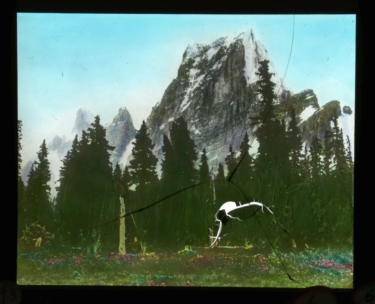
Canadian Rockies mountaineering trips, Alpine Club of Canada expeditions
https://archives.whyte.org/en/permalink/descriptions55242
- Part Of
- Malcolm Geddes fonds
- Scope & Content
- File consists of 129 lantern slides pertaining to mountaineering expeditions and scenic views in the Canadian Rockies. Includes images of pack trips, ice climbing, hiking, and Alpine Club of Canada camps. Locations include Emperor Falls; Berg Lake; ascent of Resplendent Mountain; Mount Edith Cavell…
- Date Range
- [1913-1925]
- Reference Code
- V756 / III / A / PS - 1 to 129
- Description Level
- 5 / File
- GMD
- Photograph
- Lantern slide
1 image
- Part Of
- Malcolm Geddes fonds
- Description Level
- 5 / File
- Fonds Number
- M39
- V756
- Series
- V756 / III : Personal and family records
- Sous-Fonds
- V756
- Sub-Series
- V756 / III / A : Travel and mountain expeditions
- Accession Number
- 6504
- Reference Code
- V756 / III / A / PS - 1 to 129
- Responsibility
- Some items produced by Charles Potter and James Mahon
- Date Range
- [1913-1925]
- Physical Description
- 129 photographs : lantern slides
- Scope & Content
- File consists of 129 lantern slides pertaining to mountaineering expeditions and scenic views in the Canadian Rockies. Includes images of pack trips, ice climbing, hiking, and Alpine Club of Canada camps. Locations include Emperor Falls; Berg Lake; ascent of Resplendent Mountain; Mount Edith Cavell; Mount Maud; Mount Commander; Mount Marpole; Mount Habel; Mount Robson; Mount Temple; Mount Huber; Castle Mountain; and Wilcox Pass.
- Notes
- Some items are numbered on outer edges or otherwise labelled
- Material Details
- Some items hand-coloured
- Name Access
- Gibbon, John Murray
- Wheeler, A. O. (Arthur Oliver)
- Geddes, Malcolm
- Alpine Club of Canada
- Subject Access
- Travel
- Exploration
- Hiking
- Ice climbing
- Summit
- Mountains
- Landscapes
- Recreation
- Alpine Club of Canada
- Glaciers
- Trails
- Pack trips
- Camping
- Geographic Access
- Canada
- Alberta
- British Columbia
- Canadian Rocky Mountains
- Mount Robson
- Mount Temple
- Mount Habel
- Mount Geikie
- Mount Huber
- Castle Mountain
- Wilcox Pass
- Mount Edith Cavell
- Mount Maud
- Mount Commander
- Mount Marpole
- Access Restrictions
- Fragile - restrictions may apply
- Reproduction Restrictions
- Fragile- restrictions may apply
- Language
- N/A
- Title Source
- Title based on contents of file
- Processing Status
- Processed
Images
This material is presented as originally created; it may contain outdated cultural descriptions and
potentially offensive content.
Read more.
Canadian scenes
https://archives.whyte.org/en/permalink/descriptions14787
- Part Of
- Malcolm Geddes fonds
- Scope & Content
- File consists of 20 lantern slide photographs depicting scenes in Victoria, Vancouver and vicinity in British Columbia; Edmonton, Calgary and vicinity in Alberta; Regina and other regions in Saskatchewan; Winnipeg in Manitoba; and shipping activity on the Great Lakes.
- Date Range
- [ca.1925]
- Reference Code
- V756 / III / A / PS - 312 to 331
- Description Level
- 5 / File
- GMD
- Photograph
- Lantern slide
- Part Of
- Malcolm Geddes fonds
- Description Level
- 5 / File
- Fonds Number
- M39
- V756
- Series
- V756 / III : Personal and family records
- Sous-Fonds
- V756
- Sub-Series
- V756 / III / A : Travel and mountain expeditions
- Accession Number
- 6504
- Reference Code
- V756 / III / A / PS - 312 to 331
- Responsibility
- Most images in file issued by Department of the Interior Natural Resources Intelligence Branch
- Date Range
- [ca.1925]
- Physical Description
- 20 photographs : lantern slides
- Scope & Content
- File consists of 20 lantern slide photographs depicting scenes in Victoria, Vancouver and vicinity in British Columbia; Edmonton, Calgary and vicinity in Alberta; Regina and other regions in Saskatchewan; Winnipeg in Manitoba; and shipping activity on the Great Lakes.
- Notes
- Most items in file are captioned
- Material Details
- Items in file are hand-coloured
- Subject Access
- Scenery
- Ship
- Transportation
- Travel
- Communities
- Geographic Access
- Canada
- British Columbia
- Vancouver
- Victoria
- Alberta
- Edmonton
- Calgary
- Saskatchewan
- Regina
- Manitoba
- Winnipeg
- Great Lakes
- Access Restrictions
- Fragile- restrictions may apply
- Language
- English
- Title Source
- Title based on contents of file
- Processing Status
- Processed
This material is presented as originally created; it may contain outdated cultural descriptions and
potentially offensive content.
Read more.
Cariboo Monashee Heli-Skiing
https://archives.whyte.org/en/permalink/descriptions54812
- Part Of
- Murray Hay fonds
- Scope & Content
- File consists of 1 cm of textual records, 28 x 21.5 cm. File pertains to maps related to the ski areas utilized by Helicopter Skiing Canada in Cariboo Monashee Country, created by Murray Hay. File includes reproductions of the maps in an individual promotional map with information on the back and a…
- Date Range
- ca. 1978 - ca. 1979
- Reference Code
- M570 / III / A / vii / 1
- Description Level
- 5 / File
- GMD
- Map
- Published record
- Textual record
- Part Of
- Murray Hay fonds
- Description Level
- 5 / File
- Fonds Number
- M570 / V795
- Series
- M570 / III : Murray Hay portfolio (published material)
- Sous-Fonds
- M570
- Sub-Series
- M570 / III / A : British Columbia / vii : Cariboo Monashee
- Accession Number
- 2019.41
- Reference Code
- M570 / III / A / vii / 1
- Date Range
- ca. 1978 - ca. 1979
- Physical Description
- 1 cm of textual records (28 x 21.5 cm)
- Scope & Content
- File consists of 1 cm of textual records, 28 x 21.5 cm. File pertains to maps related to the ski areas utilized by Helicopter Skiing Canada in Cariboo Monashee Country, created by Murray Hay. File includes reproductions of the maps in an individual promotional map with information on the back and a bound brochure (which also includes the map) promoting helicopter skiing.
- Notes
- Dates are approximate based on the ages of the daughter of Mike Wiegele (owner of Cariboo Monashee Helicopter Skiing Canada), who was born in 1970 and is aged 8 in the photographs included in the booklet.
- Name Access
- Hay, Murray
- Subject Access
- Ski Maps
- Skiing
- Ski touring
- Ski areas
- Helicopter skiing
- Cartography
- Tourism
- Tourist information
- Sports and recreation
- Travel
- Winter
- Winter sports
- Advertising
- Artist
- Geographic Access
- British Columbia
- Canada
- Monashee Mountains
- Cariboo Mountains
- Language
- English
- Title Source
- Title based on contents of file
- Processing Status
- Processed
This material is presented as originally created; it may contain outdated cultural descriptions and
potentially offensive content.
Read more.
Charlevoix Region
https://archives.whyte.org/en/permalink/descriptions54969
- Part Of
- Murray Hay fonds
- Scope & Content
- File consists of 1 print : col. ; 35.5 x 28 cm. File pertains to Murray Hay's work on Charlevoix, Quebec. FIle includes one print, labelled "Charlevoix Region - Quebec," that depicts the landscape of the region.
- Date Range
- ca. 1976 - ca. 2000
- Reference Code
- V795 / II / C / iii / 1
- Description Level
- 5 / File
- GMD
- Map
- Private record
- Part Of
- Murray Hay fonds
- Description Level
- 5 / File
- Fonds Number
- M570 / V795
- Series
- V795 / II : Unpublished Material
- Sous-Fonds
- V795
- Sub-Series
- V795 / II / C : Canada [general] / iii : Quebec
- Accession Number
- 2019.41
- Reference Code
- V795 / II / C / iii / 1
- GMD
- Map
- Private record
- Date Range
- ca. 1976 - ca. 2000
- Physical Description
- 1 print : col. ; 35.5 x 28 cm
- Scope & Content
- File consists of 1 print : col. ; 35.5 x 28 cm. File pertains to Murray Hay's work on Charlevoix, Quebec. FIle includes one print, labelled "Charlevoix Region - Quebec," that depicts the landscape of the region.
- Name Access
- Hay, Murray
- Subject Access
- Advertising
- Artist
- Map
- Cartography
- Tourism
- Landscapes
- Geography
- Geographic Access
- Quebec
- Canada
- Language
- English
- Creator
- Hay, Murray
- Title Source
- Title based on contents of file
- Processing Status
- Processed
This material is presented as originally created; it may contain outdated cultural descriptions and
potentially offensive content.
Read more.