Narrow Results By
1964 ski trip, skiing with friends
https://archives.whyte.org/en/permalink/descriptions55310
- Part Of
- Chic Scott fonds
- Scope & Content
- File consists of photographs pertaining to Hans Gmoser skiing with friends. Most photographs are from a 1964 ski trip between Toby Creek and the Bugaboos mountain range in British Columbia.
- Date Range
- 1964
- [1980 - 1990]
- Reference Code
- V40 / V / PA - 1 to 24
- Description Level
- 5 / File
- Part Of
- Chic Scott fonds
- Description Level
- 5 / File
- Fonds Number
- M57
- S47
- V40
- Series
- V40 / V : Deep Powder and Steep Rock
- Sous-Fonds
- V40
- Accession Number
- 2015.8559
- Reference Code
- V40 / V / PA - 1 to 24
- Date Range
- 1964
- [1980 - 1990]
- Physical Description
- 24 photographs : b&w and col. prints; 25 x 20 cm or smaller
- Scope & Content
- File consists of photographs pertaining to Hans Gmoser skiing with friends. Most photographs are from a 1964 ski trip between Toby Creek and the Bugaboos mountain range in British Columbia.
- Notes
- Photographs in file are accompanied by one page of handwritten notes pertaining to details of images from 1964 ski trip [PA - 1 to 21] and one copy of an Eaton's newspaper ad featuring an illustration of a ski jumper
- Name Access
- Gmoser, Hans
- McConkey, Jim
- Wiegele, Mike
- Grillmair, Leo
- Gertsch, Rudy
- Gmoser, Margaret
- Lemire, Pierre
- Subject Access
- Sports
- Recreation
- Skiing
- Ski jumping
- Mountains
- Landscapes
- Family and personal life
- Exploration
- Travel
- Winter
- Winter sports
- Geographic Access
- Canada
- British Columbia
- Toby Creek
- Bugaboos
- Canadian Rocky Mountains
- Reproduction Restrictions
- Restrictions may apply
- Language
- English
- Title Source
- Title based on contents of file
- Processing Status
- Processed
This material is presented as originally created; it may contain outdated cultural descriptions and
potentially offensive content.
Read more.
Abbot Pass and Mount Geikie ascent
https://archives.whyte.org/en/permalink/descriptions55238
- Part Of
- Malcolm Geddes fonds
- Scope & Content
- File consists of 5 b&w photographs pertaining to the 1924 ascent of Mount Geikie and a hike through Abbot Pass. Includes group images of Malcolm Geddes, Harry Pollard, T.B. Moffat, Alvin Geddes, and various unidentified members of the Alpine Club of Canada.
- Date Range
- [1922 - 1927]
- 1924
- Reference Code
- V756 / III / A / PA - 20 to 24
- Description Level
- 5 / File
- GMD
- Photograph
- Photograph print
- Part Of
- Malcolm Geddes fonds
- Description Level
- 5 / File
- Fonds Number
- M39
- V756
- Series
- V756 / III : Personal and family records
- Sous-Fonds
- V756
- Sub-Series
- V756 / III / A : Travel and mountain expeditions
- Accession Number
- 2015.8558
- Reference Code
- V756 / III / A / PA - 20 to 24
- Date Range
- [1922 - 1927]
- 1924
- Physical Description
- 5 photographs : b&w prints ; 18 x 24 cm or smaller
- Scope & Content
- File consists of 5 b&w photographs pertaining to the 1924 ascent of Mount Geikie and a hike through Abbot Pass. Includes group images of Malcolm Geddes, Harry Pollard, T.B. Moffat, Alvin Geddes, and various unidentified members of the Alpine Club of Canada.
- Notes
- Items are annotated on back
- Material Details
- One print is attached to a partial sheet of graph paper
- Name Access
- Geddes, Malcolm
- Pollard, Harry
- Moffat, Thomas B.
- Geddes, Alvin
- Subject Access
- Climbing
- Exploration
- Hiking
- Mountaineering
- Mountains
- Recreation
- Sports
- Summit
- Geographic Access
- Canada
- Alberta
- Abbot Pass
- British Columbia
- Mount Geikie
- Reproduction Restrictions
- Restrictions may apply
- Language
- English
- Conservation
- Items are stored in mylar
- Title Source
- Title based on contents of file
- Processing Status
- Processed
This material is presented as originally created; it may contain outdated cultural descriptions and
potentially offensive content.
Read more.
Auyuittuq National Park
https://archives.whyte.org/en/permalink/descriptions54979
- Part Of
- Murray Hay fonds
- Scope & Content
- File consists of 1 painting : landscape ; 50.5 x 39.5 cm. File pertains to a map Murray Hay created of Auyuittuq National Park in Nunavut, Canada. File includes 1 colour painting of the park and surrounding area (Nunavut, Baffin Island) and one sheet of tracing paper that is annotated and taped wit…
- Date Range
- ca.1980-ca.1989
- Reference Code
- V795 / II / C / vi / 1
- Description Level
- 5 / File
- GMD
- Map
- Painting
- Private record
- Part Of
- Murray Hay fonds
- Description Level
- 5 / File
- Fonds Number
- M570 / V795
- Series
- V795 / II : Unpublished Material
- Sous-Fonds
- V795
- Sub-Series
- V795 / II / C : Canada [general] / vi : Auyuittuq National Park
- Accession Number
- 2020.03
- Reference Code
- V795 / II / C / vi / 1
- Date Range
- ca.1980-ca.1989
- Physical Description
- 1 painting : landscape ; 50.5 x 39.5 cm
- Scope & Content
- File consists of 1 painting : landscape ; 50.5 x 39.5 cm. File pertains to a map Murray Hay created of Auyuittuq National Park in Nunavut, Canada. File includes 1 colour painting of the park and surrounding area (Nunavut, Baffin Island) and one sheet of tracing paper that is annotated and taped with masking tape over the painting.
- Name Access
- Hay, Murray
- Subject Access
- Advertising
- Artist
- Map
- Cartography
- Painting
- Geography
- Tourism
- Tourist information
- Travel
- National parks and reserves
- Auyuittuq National Park
- Geographic Access
- Auyuittuq National Park
- Nunavut
- Canada
- Language
- English
- Conservation
- Masking tape should be removed and alternative preservation methods should be considered at a reasonable time to do so.
- Creator
- Hay, Murray
- Title Source
- Title based on contents of file
- Processing Status
- Processed
This material is presented as originally created; it may contain outdated cultural descriptions and
potentially offensive content.
Read more.
Banff National Park (general)
https://archives.whyte.org/en/permalink/descriptions55338
- Part Of
- Murray Hay fonds
- Scope & Content
- File consists of 4 prings : col. 35.1 x 24.8 cm or smaller and 4 maps (2 paper, 2 overlays) : col., on mylar ; 60.4 x 30. cm or smaller. File pertains to aerial views of Banff National Park, showing the towns of Banff and Lake Louise, ski hills (Norqay Ski Hill, Sunshine Village, and Lake Louise Sk…
- Date Range
- ca.1976-ca.2000
- Reference Code
- V795 / II / B / v / 1-2
- Description Level
- 5 / File
- GMD
- Map
- Private record
- Part Of
- Murray Hay fonds
- Description Level
- 5 / File
- Fonds Number
- M570 / V795
- Series
- V795 / II : Unpublished Material
- Sous-Fonds
- V795
- Sub-Series
- V795 / II / B : Alberta / v : Banff National Park
- Accession Number
- 2019.41
- Reference Code
- V795 / II / B / v / 1-2
- GMD
- Map
- Private record
- Date Range
- ca.1976-ca.2000
- Physical Description
- 4 prints : col. 35.1 x 24.8 cm or smaller
- 4 maps (2 paper, 2 overlays) : col., annotations, on mylar ; 60.4 x 30. cm or smaller
- Scope & Content
- File consists of 4 prings : col. 35.1 x 24.8 cm or smaller and 4 maps (2 paper, 2 overlays) : col., on mylar ; 60.4 x 30. cm or smaller. File pertains to aerial views of Banff National Park, showing the towns of Banff and Lake Louise, ski hills (Norqay Ski Hill, Sunshine Village, and Lake Louise Ski Resort), as well as other georgraphic features. The mylar overlays contain various amounts of detail and annotations - one consists of a dark red sheet overlayed with place names in negative.
- Notes
- Items not in oversize stored in downstairs vault.
- Name Access
- Hay, Murray
- Subject Access
- Advertising
- Artist
- Ski Maps
- Map
- Cartography
- Sports and recreation
- Tourism
- Tourist information
- Winter
- Winter sports
- Ski area
- Sunshine Village
- Norquay Ski Hill
- Lake Louise Ski Area
- Geographic Access
- Banff
- Lake Louise
- Banff National Park
- Alberta
- Canada
- Canadian Rocky Mountains
- Language
- English
- Creator
- Hay, Murray
- Title Source
- Title based on contents of file
- Processing Status
- Processed
This material is presented as originally created; it may contain outdated cultural descriptions and
potentially offensive content.
Read more.
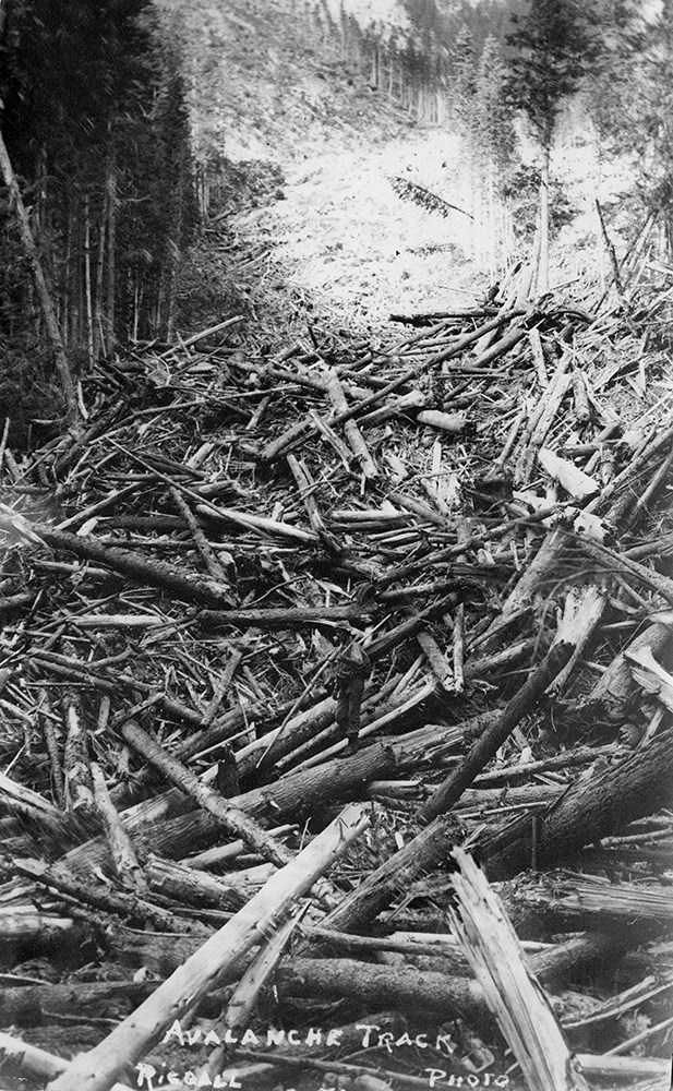
Bert Riggall's 1000 Mile Pack trip
https://archives.whyte.org/en/permalink/descriptions23454
- Part Of
- Bert Riggall fonds
- Scope & Content
- File consists of 43 b&w photographs, some captioned. Photographs pertain to Riggall's 1911 1000 mile pack trip undertaken to seek out areas for hunting and outfitting following the enlargement of Waterton National Park and the reduction of available hunting area for Riggall's clients. The prints do…
- Date Range
- 1911
- Reference Code
- V26 / II / A7 / PA - 119 to 161
- Description Level
- 5 / File
- GMD
- Photograph
- Photograph print
1 image
- Part Of
- Bert Riggall fonds
- Description Level
- 5 / File
- Fonds Number
- M376 / V26
- Series
- II.Business and Financial: Bert Riggall's 1000 Mile Pack trip, 1911
- Sous-Fonds
- V26
- Accession Number
- 7201
- Reference Code
- V26 / II / A7 / PA - 119 to 161
- Date Range
- 1911
- Physical Description
- 43 photographs: b&w prints
- Scope & Content
- File consists of 43 b&w photographs, some captioned. Photographs pertain to Riggall's 1911 1000 mile pack trip undertaken to seek out areas for hunting and outfitting following the enlargement of Waterton National Park and the reduction of available hunting area for Riggall's clients. The prints document this pack trip from stops in Banff, AB and Cranbrook, BC, and the extent of his mountain exploration from Fort Steele to Edson. On this trip, approximately 150 miles of new trail was cut including portions of Roger's Pass.
- Subject Access
- Pack trips
- Exploration
- Trails
- Trail making
- Recreation
- Hunting
- Outfitters, trail guides and packers
- Geographic Access
- Canada
- Alberta
- Banff National Park
- Waterton National Park
- British Columbia
- Cranbrook
- Rogers Pass
- Language
- English
- Title Source
- Title based on contents of file
- Processing Status
- Processed
Images

This material is presented as originally created; it may contain outdated cultural descriptions and
potentially offensive content.
Read more.
Bert Riggall's 1000 Mile Pack trip
https://archives.whyte.org/en/permalink/descriptions23455
- Part Of
- Bert Riggall fonds
- Scope & Content
- File consists of 20 b&w photographs, some captioned. Photographs pertain to Riggall's 1911 1000 mile pack trip undertaken to seek out areas for hunting and outfitting following the enlargement of Waterton National Park and the reduction of available hunting area for Riggall's clients. The prints do…
- Date Range
- 1911
- Reference Code
- V26 / II / A7 / PA - 162 to 181
- Description Level
- 5 / File
- GMD
- Photograph
- Photograph print
1 image
- Part Of
- Bert Riggall fonds
- Description Level
- 5 / File
- Fonds Number
- M376 / V26
- Series
- II.Business and Financial: Bert Riggall's 1000 Mile Pack trip, 1911
- Sous-Fonds
- V26
- Accession Number
- 7201
- Reference Code
- V26 / II / A7 / PA - 162 to 181
- Date Range
- 1911
- Physical Description
- Photographs: 20 prints, b&w
- Scope & Content
- File consists of 20 b&w photographs, some captioned. Photographs pertain to Riggall's 1911 1000 mile pack trip undertaken to seek out areas for hunting and outfitting following the enlargement of Waterton National Park and the reduction of available hunting area for Riggall's clients. The prints document this pack trip from stops in Banff, AB and Cranbrook, BC, and the extent of his mountain exploration from Fort Steele to Edson. On this trip, approximately 150 miles of new trail was cut including portions of Roger's Pass.
- Subject Access
- Pack trips
- Exploration
- Trails
- Trail making
- Recreation
- Hunting
- Outfitters, trail guides and packers
- Geographic Access
- Canada
- Alberta
- Banff National Park
- Waterton National Park
- British Columbia
- Cranbrook
- Rogers Pass
- Language
- English
- Title Source
- Title based on contents of file
- Processing Status
- Processed
Images
This material is presented as originally created; it may contain outdated cultural descriptions and
potentially offensive content.
Read more.
Big White Ski Village
https://archives.whyte.org/en/permalink/descriptions54801
- Part Of
- Murray Hay fonds
- Scope & Content
- File consists of 0.5 cm of textual records, 90 x 60.5 cm. File pertains to ski trail maps of Big White Ski Village and Area created by Murray Hay. File includes one oversized published reproduction of a Big White trail map in poster format.
- Date Range
- ca.1980 - ca.2000
- Reference Code
- M570 / III / A / v / 1
- Description Level
- 5 / File
- GMD
- Map
- Poster
- Published record
- Textual record
- Part Of
- Murray Hay fonds
- Description Level
- 5 / File
- Fonds Number
- M570 / V795
- Series
- M570 / III : Murray Hay portfolio (published material)
- Sous-Fonds
- M570
- Sub-Series
- M570 / III / A : British Columbia / v : Big White
- Accession Number
- 2019.41
- Reference Code
- M570 / III / A / v / 1
- Date Range
- ca.1980 - ca.2000
- Physical Description
- 0.5 cm of textual records (90 x 60.5 cm)
- Scope & Content
- File consists of 0.5 cm of textual records, 90 x 60.5 cm. File pertains to ski trail maps of Big White Ski Village and Area created by Murray Hay. File includes one oversized published reproduction of a Big White trail map in poster format.
- Name Access
- Hay, Murray
- Subject Access
- Ski Maps
- Map
- Ski area
- Skiing
- Tourism
- Travel
- Winter
- Winter sports
- Sports and recreation
- Big White Ski Area
- Tourist information
- Artist
- Advertising
- Geographic Access
- Kelowna
- British Columbia
- Canada
- Language
- English
- Related Material
- V795 / II / A / iv / 5
- Title Source
- Title based on contents of file
- Processing Status
- Processed
This material is presented as originally created; it may contain outdated cultural descriptions and
potentially offensive content.
Read more.
Bow Valley area, mountain ranges and views
https://archives.whyte.org/en/permalink/descriptions55530
- Part Of
- Luxton family fonds
- Scope & Content
- File consists of 34 photographs depicting views of the Bow Valley and surrounding areas, and Quebec. Depicted locations include Chinaman's Peak (now Ha Ling), End Mountain, Fairholme Range, Mount McDougall, Mount Chester, Mount Galatea, Fisher Range in Kananaskis, Mount Lougheed and Mount Sparrowha…
- Date Range
- 1938-1939
- Reference Code
- LUX / III / D / PA - 171 to 204
- Description Level
- 5 / File
- GMD
- Photograph
- Part Of
- Luxton family fonds
- Description Level
- 5 / File
- Fonds Number
- LUX
- Series
- LUX / III / D : Other material
- Sous-Fonds
- LUX / III : Luxton family sous-fonds
- Accession Number
- LUX
- Reference Code
- LUX / III / D / PA - 171 to 204
- GMD
- Photograph
- Date Range
- 1938-1939
- Physical Description
- 34 photographs : b&w prints ; 11 x 7 cm
- Scope & Content
- File consists of 34 photographs depicting views of the Bow Valley and surrounding areas, and Quebec. Depicted locations include Chinaman's Peak (now Ha Ling), End Mountain, Fairholme Range, Mount McDougall, Mount Chester, Mount Galatea, Fisher Range in Kananaskis, Mount Lougheed and Mount Sparrowhawk in Alberta; and the Laurentian Mountains and St Adele (Quebec).
- Notes
- Some photographs are individually captioned with locations, dates and other related information
- Subject Access
- Exploration
- Travel
- Mountains
- Landscapes
- Environment
- Hiking
- Recreation
- Summit
- Geographic Access
- Canada
- Alberta
- Bow Valley
- Kananaskis
- Quebec
- Reproduction Restrictions
- Copyright status unknown
- Language
- English
- Conservation
- Items stored in mylar
- Title Source
- Title based on contents of file
- Processing Status
- Processed
This material is presented as originally created; it may contain outdated cultural descriptions and
potentially offensive content.
Read more.
Brochure production
https://archives.whyte.org/en/permalink/descriptions54929
- Scope & Content
- File consists of notes, clippings and drafts of brochures to be published by the Trail Riders of the Canadian Rockies. File also includes several illustrations of trail maps to be included in brochures, correspondence pertaining to brochure production, model release forms and three duplicate b&w pr…
- Date Range
- 1980-1985
- Reference Code
- M545 / V / 29 & 30
- Description Level
- 5 / File
- GMD
- Textual record
- Published record
- Organization record
- Description Level
- 5 / File
- Fonds Number
- M545 / V635
- Series
- M545 / V : Administrative records
- Sous-Fonds
- M545
- Accession Number
- 5939
- Reference Code
- M545 / V / 29 & 30
- Date Range
- 1980-1985
- Physical Description
- 2.5 cm of textual records (21.5 x 28 cm or smaller) -- 3 photographs : b&w prints ; 9 x 9 cm
- Scope & Content
- File consists of notes, clippings and drafts of brochures to be published by the Trail Riders of the Canadian Rockies. File also includes several illustrations of trail maps to be included in brochures, correspondence pertaining to brochure production, model release forms and three duplicate b&w prints depicting several trail riders on horseback [image used in 1980 brochure].
- Notes
- Six "Holiday on Horseback" brochures removed from file. Items are duplicates of brochures processed in series M545 / II and will be offered for return to Trail Riders of the Canadian Rockies.
- File contents organized by date and stored in two folders [see "Content Details"]
- Subject Access
- Administration
- Advertising
- Tourism
- Travel
- Organizations
- Membership
- Businesses
- Geography
- Horse packing
- Horseback riding
- Trails
- Hotels
- Geographic Access
- Canada
- Alberta
- Calgary
- Banff
- Language
- English
- Conservation
- Prints placed in mylar and stored in folder with related textual material to preserve context
- Category
- Exploration, discovery and travel
- Sports, recreation and leisure
- Communications
- Commerce and industry
- Title Source
- Title based on contents of file
- Processing Status
- Processed
This material is presented as originally created; it may contain outdated cultural descriptions and
potentially offensive content.
Read more.
- Scope & Content
- File consists of Trail Riders of the Canadian Rockies bulletins from 1931-1974 [some annotated] and one "Skyline Trails" bulletin [1960]. Content pertains to views and events from previous trips, schedules and planned destinations of trail rides, and membership lists.
- Date Range
- 1931
- 1939
- 1941-1942
- 1944-1945
- 1948-1953
- 1955-1957
- 1960-1962
- 1964
- 1970
- 1972
- 1974
- Reference Code
- M545 / III / 8 to 11
- Description Level
- 5 / File
- GMD
- Textual record
- Published record
- Organization record
- Description Level
- 5 / File
- Fonds Number
- M545 / V635
- Series
- M545 / III : Published records
- Sous-Fonds
- M545
- Accession Number
- 5939
- Reference Code
- M545 / III / 8 to 11
- Date Range
- 1931
- 1939
- 1941-1942
- 1944-1945
- 1948-1953
- 1955-1957
- 1960-1962
- 1964
- 1970
- 1972
- 1974
- Physical Description
- 8 cm of textual records
- Scope & Content
- File consists of Trail Riders of the Canadian Rockies bulletins from 1931-1974 [some annotated] and one "Skyline Trails" bulletin [1960]. Content pertains to views and events from previous trips, schedules and planned destinations of trail rides, and membership lists.
- Notes
- Brochures are organized by date [see "Content Details"]
- Subject Access
- Advertising
- Administration
- Membership
- Horses
- Horseback riding
- Camping
- Entertainment
- Travel
- Tourism
- Publication
- Geographic Access
- Canada
- Alberta
- Banff
- Moraine Lake
- Lake Louise
- Stewart Canyon
- Spray Lakes
- Larix Lake
- Fatigue Pass
- Ptarmigan Lake
- Mount Assiniboine
- Deception Pass
- Wolverine Plateau
- Simpson Pass
- Wonder Pass
- Kananaskis
- Johnston Creek
- Panther River
- Red Deer
- Lake O'Hara
- Pulsatilla Pass
- Reproduction Restrictions
- Restrictions may apply
- Language
- English
- Title Source
- Title based on contents of file
- Content Details
- M545 / III / 8 : 1931-1948
- M545 / III / 9 : 1949-1953
- M545 / III / 10 : 1955-1962
- M545 / III / 11 : 1964-1974
- Processing Status
- Processed
This material is presented as originally created; it may contain outdated cultural descriptions and
potentially offensive content.
Read more.